A vifauna and anthropogenic forest disturbance in two biodiversity hotspots
Thesis submitted in partial fulfilment of the requirements for the degree
o f Doctor of Philosophy
by
Thomas Edward Martin
Bsc (Hons) Geography
Lancaster Environment Centre
Lancaster University
Submitted 16/10/09
ProQuest Number: 11003466
All rights reserved INFORMATION TO ALL USERS
The qu ality of this repro d u ctio n is d e p e n d e n t upon the q u ality of the copy subm itted. In the unlikely e v e n t that the a u th o r did not send a c o m p le te m anuscript and there are missing pages, these will be note d . Also, if m aterial had to be rem oved,
a n o te will in d ica te the deletion.
uest
ProQuest 11003466
Published by ProQuest LLC(2018). C op yrig ht of the Dissertation is held by the Author. All rights reserved.
This work is protected against unauthorized copying under Title 17, United States C o d e M icroform Edition © ProQuest LLC.
ProQuest LLC.
789 East Eisenhower Parkway P.O. Box 1346
I, Thomas Martin, declare that the research presented in this thesis represents
my own work, and this body o f work has not been submitted elsewhere for the
award o f higher degree.
Avifauna and anthropogenic disturbance in two biodiversity hotspots
This thesis is submitted in partial fulfilment of the requirements for the degree of Doctor of Philosophy by Thomas Edward Martin, Lancaster Environment Centre. October 2009.
Abstract
The primary objective of this thesis is to examine the impact of anthropogenic forest
disturbance on avifaunal communities in two biodiversity hotspots- lowland tropical forest in the Lambusango Forest Reserve within the Wallacean archipelago and Neotropical cloud forest in Cusuco National Park, Mesoamerica. Both these study areas possess diverse bird communities with high rates of endemism, yet are under severe pressure from anthropogenic activity. The research also evaluates the optimal methodologies for surveying bird
communities in these poorly studied ecosystems and examines the extent to which under- managed protected areas can be successful in preserving bird species with high
conservational importance, and the habitat associations of these avifaunal communities. Results demonstrate that point count methods are more effective than mist-nets for describing cloud forest bird communities. Research also shows that many Wallacean species are tolerant o f moderate habitat disturbance, although endemic species are sensitive to heavy disturbance. Cloud forest endemics appear to be sensitive to moderate disturbance, although protected areas can be effective in preserving these species even where severely undermanaged.
Endemic birds in the two hotspots display different responses to habitat disturbance; this may be due to differential community compositions, niche competition and biogeography.
Research has also demonstrated that richness and composition of Wallacean bird
communities have strong associations with a range o f habitat variables which can be used to provide proxy data for identifying priority conservation areas when appropriate scales of data aggregation are used. The findings of this thesis demonstrate the value of using multiple research perspectives to fully investigate geographical problems.
Acknowledgements
This thesis could not have been produced without the assistance and support of a great many people from Lancaster University and Operation Wallacea, as well as from friends and family. I would like to thank the following people for the help, kindness and patience shown towards me during the last three years. Many others have also shown me great support and kindness and apologies are given to those whose names are omitted here.
At Lancaster University I would first and foremost like to thank my supervisor, Dr Alan Blackburn, for his sound advice, unwavering support and seemingly endless patience. I would also like to thank Dr Jos Barlow for advice offered at numerous junctures during the course of producing this thesis. I would additionaly like to thank my fellow postgraduate students for their tolerance of pestering questions and moaning.
From the Lambusango I would firstly like to thank Mr Dani Heriyadi, Mr Henry Singh and Mr Tasman for their help and great enthusiasm in conducting bird surveys in the
Lambusango. I would also like to thank my guide, Mr Kasima, Arthur Arfion and Dr Phil Wheeler for his advice and logistical support.
In Cusuco I would like to thank most of all W ilf Simcox for his advice, support and unrivalled mist-netting skill. I would also like to thank the 2007 ornithology team; Martin Meads, Chris Hill, Ernesto Reyes and Sarah Rustage. I would additionally like to thank Dr Tim Coles and Jose Nunez-Mino of Operation Wallacea for making the fieldwork this thesis is based on possible.
Finally, I would like to thank my friends and family for their amazing patience and support, especially mum — my proof-reader extraordinaire.
Title page
Abstract
Acknowledgements
Contents
List o f figures
List o f tables
List o f Plates
Contents
13
4
5
13
18
Chapter 1: Introduction
1.1 - Overview 1.2 - Wallacea 1.3 - Mesoamerica 1 .4 - Research objectives 1.5 - Operation Wallacea1.6 - The Lambusango Forest
1.7 - Cusuco National Park
1.8 - Thesis structure
1.9 - References
Chapter 2: Literature Review - Habitat loss and avifauna
research problems and opportunities
2.2 - Tropical forests, habitat destruction and biodiversity: an overview 54
2.2.1 - Tropical forests 54
2.2.2 — Tropical deforestation - causes and consequences 56
2.2.3 - Biodiversity - richness, distribution, importance and loss 59
2.3 - Conservation policy and avifauna - problems and opportunities 64
2.3.1 - Monitoring biodiversity: limitations of the ‘data vaccunT 64
2.3.2 - Indicator taxa 66
2.3.3 - The value of birds 67
2.4 - Research opportunities 69
2.4.1 - Poor records of base-line avifaunal data 69
2.4.2 - Insufficient methodological research 71
2.4.3 - Lack of understanding of relationships between habitat disturbance and
bird communities in poorly studied forest habitats 74
2.4.4 - Insufficient research evaluating success of undermanaged conservation
schemes in poorly studied forest ecosystems 75
2.4.5 - Poor understanding of habitat associations of birds in the study areas,
and the role of spatial scale in understanding these associations 76
2.5 - Summary 77
2.6 - References 78
Chapter 3: An assessment of the effectiveness of two methods
in describing a Neotropical cloud forest bird community
88
3.2 - Introduction 90 3.3 - Methods 93 3.3.1 - Study area 93 3.3.2 - Bird surveys 95 3.3.3 - Statistical analysis 97 3.4 - Results 98 3.5 - Discussion 107 3.6 - References 113 A
Chapter 4 - Impacts of tropical forest disturbance upon avifauna
on a sm a ll island w ith high endem ism : im p lication s for con servation 118
4.1- Summary 119 4.2 - Introduction 120 4 .3-M eth od s 122 4.3.1 - Study area 122 4.3.2 - Sample sites 123 4.3.3 - Vegetation sampling 125
8
4.3.4 - Bird sampling 126 4.3.5 - Statistical analysis 127 4 .4 -R esu lts 128 4.5 - Discussion 137 4.6 - Conclusion 141 4.7 - References 143
Chapter 5 - The effectiveness of a Mesoamerican ‘Paper park’
in conserving cloud forest avifauna
148
5 .1 -S u m m ary 149 5.2 - Introduction 150 5 .3 -M eth od s 153 5.3.1 - Study site 153 5.3.2 - Habitat surveys 154 5.3.3 - Bird surveys 155 5 . 3 .4 - Statistical analysis 155 5 .4 -R esu lts 157
5.5 - Discussion 167
5.6 - Conclusion 173
5.7 - References 174
Chapter 6 - Habitat associations of an insular Wallacean
avifauna: a multi-scale approach for biodiversity proxies
181
6 .1-S u m m ary 182 6.2 - Introduction 183 6 .3-M eth od s 187 6.3.1 - Study site 187 6.3.2 - Sample sites 187 6.3.3 - Bird surveys 190 6.3.4 - Vegetation analysis 190 6.3.5 - Remotely-sensed data 190
6.3.6 - Scaling and data aggregation 191
6.3.7 - Statistical analysis 192
6.4 - Results 193
6 .4 .1 - A r e a scale analysis 193
6.4.2 - Transect scale 198
6.4.3 - Points scale 201
6.5 - Discussion 201
6.6 - Conclusion 206
6.7 - References 209
Chapter 7 -Differential vulnerabilities of range-restricted avifauna
on a Wallacean Island and in Mesoamerican cloud forest:
the influence of ecological and biogeographical factors?
214
7.1 - Summary 215
7.2 - Introduction 216
7.3 - Methodology 219
7.3.1 - Comparisons of ‘high risk’ characteristics 219
7.3.2 - Study sites, vegetation surveys and bird surveys 220
7.3.3 - Bird census data aggregation and statistical analysis 220
7.4 - Results 221
7.5 - Discussion 229
7.5.2 - High vegetation diversity 234 7.5.3 - Low specialisation and ecological distinctiveness of endemic species 236 7.5.4 - Presence of strangler figs as a food resource in degraded forest habitats 238
7.5.5 - Climate and natural disturbance patterns 240
7.5.6 - History of human settlement 243
7.6 - Further research 247 7.7 - Conclusion 250 7.8 - References 251
Chapter 8 - Conclusion
258
8.1 - Research summary 259 8.2 - Further research 261Appendix 1: The avifauna of the Lambusango Reserve and vicinity 266
Appendix 2: Morphometric data for Mesoamerican
cloud forest bird species 287
Appendix 3: Photographic examples of study site 298
A p p e n d i x 4: - Progress of papers submitted for peer-review 305
List of figures
1.1 - Global biodiversity hotspots 25
1.2 - The Indonesian archipelago, with boundaries of the Wallacean region shown 27
1.3 - Biogeographical boundaries in the Wallacea region 28
1.4 - The Mesoamerican hotspot 33
1.5 - The Indonesian archipelago 38
1.6 - Monthly climatic data for Buton Island 38
1.7 - Forest categories and study sites within the Lambusango reserve 40
1.8 - Central America and Cusuco National Park 41
1.9 - Monthly climatic data for Cusuco National Park 42
1.10 - Forest categories and study sites within Cusuco National Park 43
1.11 - Conceptual diagram identifying research objectives 46
2.2 - Global population projections 1950 - 2050 58
3.1 - Location of point-count and mist-net study sites within the border of
Cusuco National Park, Honduras 94
3.2 - Cumulative number of species detected by mist netting and point counts
with increasing survey effort 102
4.1 - The Lambusango Forest reserve and relative locations of study transects 124
4.2 - Mean number avifaunal species, endemic avifaunal species and forest species detected per sample in primary forest, regenerating secondary forest, disturbed secondary forest and cleared agricultural land within
the Lambusango forest reserve 131
4.3 - Sample-based rarefaction curves displaying number o f individuals against number of species recorded in primary forest, regenerating secondary forest, disturbed secondary forest and cleared agricultural land sample sites
within the Lambusango forest reserve 133
4.4 - Mean abundance of select Sulawesi endemic species detected per plot in primary forest, regenerating secondary forest, disturbed secondary forest
and cleared agricultural land within the Lambusango forest reserve 135
4.5 - Mean abundance per plot of: a) Coucal species Centropus celebensis and
Centropus bengalensis, and b) W hite-eye species Zoster ops consobrinorum and Zoster ops chloris in prim ary forest, regenerating secondary forest, disturbed secondary forest and cleared agricultural land w ithin the
Lam busango forest reserve 136
5.1 - Sample-based rarefaction curves comparing num ber o f individuals against num ber o f species detected in deep core, boundary core and buffer points w ithin
Cusuco N ational Park, Honduras 159
5.2 - V ariation in species per sample with altitude for buffer, boundary core
and deep core zone points within Cusuco National Park, Honduras 161
5.3 - M ean Resplendent Quetzal, Highland Guan, and Galliform contacts per sample in deep core, boundary core and buffer points within
Cusuco N ational Park, Honduras 162
5.4 - M ean relative density o f Turdidae, Troglodytidae and Corvidae species
detected by point count samples in deep core, boundary core and buffer points
w ithin Cusuco N ational Park, Honduras 164
5.5 - M ean relative density o f bird species restricted to the M esoamerican hotspot per sample in deep core, boundary core and buffer points
w ithin Cusuco National Park, Honduras 166
birds detected against num ber o f highland forest species detected in deep core, boundary core and buffer sites at altitudes of> 1000m
in Cusuco National Park, Honduras 167
6.1 - The Lam busango Forest reserve and locations o f study transects 189
6.2 - Sample-based rarefaction curves displaying num ber o f individuals against num ber o f species recorded in prim ary forest, regenerating secondary forest
and disturbed secondary forest sample sites w ithin the Lambusango forest reserve 197
7.1 - M ean species endem ic to the Wallacea hotspot detected per site in
prim ary forest, regenerating forest, disturbed secondary forest and cleared farm land in the Lambusango Forest, and m ean species endem ic to the M esoam erican hotspot detected per site in deep core, boundary core and
buffer zone sites w ithin Cusuco National Park 225
7.2 - Sample-based rarefaction curves displaying num ber o f individual birds detected against a) num ber o f endemic species detected in prim ary forest, regenerating secondary forest and disturbed secondary w ithin the Lam busango forest reserve and b) number o f highland forest species detected in deep core forest, boundary core forest and buffer zone forest
7.3 - Distribution of tropical cyclone tracks 1945 - 2006 in relation to study locations
8.1 - Conceptual diagram summarising main research findings
243
List of tables
2.1 - Select definitions of the term ‘biodiversity’ 60
3.1 - Summary of families and number of species detected by mist netting and
point counts, as well as both or neither methodologies, in Cusuco National Park 100
3.2 - Non-parametric species estimators for mist-netting and point count survey
efforts in Cusuco National Park 101
3.3 - Proportion of species in different categories detected by mist netting,
point counting, both methods and neither method at all points in comparison
to the preliminary check-list of birds of Cusuco National Park 103
3.4 - Mean proportion o f species in different categories detected per individual point for mist netting, point counts and both methods in
Cusuco National Park 106
3.5 - Mean number of species and individual birds captured at sites
o f d if f e r in g topography within Cusuco National Park 1 1 0
4.1 - Vegetation analysis summary for primary forest, regenerating secondary forest, disturbed secondary forest and cleared agricultural land within
the Lambusango Forest Reserve 126
4.2 - M ean num ber o f individuals per point count sample o f each recorded species in prim ary forest, regenerating secondary forest, disturbed secondary forest
and cleared agricultural land within the Lam busango Forest Reserve 129
4.3 - N on-param etric species estimators for prim ary forest, regenerating
secondary forest, disturbed secondary forest and cleared agricultural land
w ithin the Lambusango Forest Reserve 132
4.4 - M antel test r-values comparing community similarity o f bird assemblages betw een prim ary forest, regenerating secondary forest, disturbed secondary
forest and cleared farmland in the Lambusango Forest Reserve 134
5.1 - V egetation analysis summary for deep core, boundary core and buffer
zone points w ithin Cuscuo National Park 158
5.2 - Species richness estimates for a) all bird species, and b) highland species at altitudes o f > 1000m in deep core, boundary core and buffer
points w ithin Cusuco National Park 160
5.3 - Five m ost commonly occurring species in deep core, boundary core
and buffer points within Cusuco N ational Park 163
5.4 - Size in hectares o f total park area, core zone size, buffer zone size and % o f park as buffer for a selection o f protected cloud forest areas
6.1 - Vegetation analysis summary for study areas within the Lambusango
Forest Reserve 187
6.2 - Sample percentage discrimination (SIMPER) test displaying species contributing most to average community dissimilarity between forest
categories in the Lambusango Forest Reserve 194
6.3 - Sample percentage discrimination (SIMPER) test displaying top
five species contributing most to average community similarity between
forest categories in the Lambusango Forest Reserve 196
- 6.4 - Non-parametric species estimators for primary forest, regenerating secondary forest and disturbed secondary forest within the
Lambusango Forest Reserve 197
6.5 - Mantel test r-values comparing a) similarity of bird communities and habitat structure variables, and b) similarity of bird communities
and remote sensing variables (bands 1-7), in the Lambusango Forest Reserve 199
6.6 - Significant step-wise general linear model correlations between species richness of bird communities and sub-groups and vegetation and remote sensing variables on transect-scale data aggregations in the
Lambusango Forest Reserve 200
7.1 - Comparison of characteristics of endemic bird assemblages in the Lambusango
Forest Reserve, Buton Island, South-East Sulawesi and endemic and
highland-restricted species in Cusuco National Park 222
7.2 - Vegetation variables in a) primary forest, regenerating secondary forest and disturbed secondary forest in the Lambusango Forest Reserve, and b) deep
core, boundary core and buffer zone sites in Cusuco National Park 223
7.3 - Non-parametric species estimators for a) primary forest, regenerating secondary forest, disturbed secondary forest and cleared agricultural land within the Lambusango Forest Reserve, and b) deep core, boundary core and
buffer zone sites within Cusuco National Park 227
7.4 - Comparison of richness of avifaunal families represented by at least one endemic species in the Lambusango Forest Reserve with richness of these
families to the West o f Wallacea in Borneo and to the East in New Guinea 234
7.5 - Taxonomical relationships of endemics found in the Lambusango 237
7.6 - Approximate dates of human colonisation of oceanic archipelagos with
high rates o f avifaunal endemism 244
A l .l - Checklist of bird species recorded in the Lambusango Reserve and
vicinity between 1999 — 2000 283
List of plates
2.1. - The Wine-throated Hummingbird Selasphorus ellioti 71
2.2a. - A mist-net line 72
2.2b - Surveyor conducting an acoustical point count 72
A3.1 - A stand of large hardwood trees in the limited production forest 299
A3.2 - A viewpoint over the high forest canopy of the primary forest 299
A3.3 - Smaller trees in regenerating secondary forest in the strict reserve 300
A3.4 - A large strangler fig in secondary forest habitats within the Lambusango 300
A3.5 - Disturbed secondary forest around the Lambusango’s periphery 301
A3.6 - Cleared farmland surrounding the Lambusango’s borders 301
A3.7 - Bosque enano elfin forest in the highest elevations of the core zone 302
A3.8 - A stand of large hardwood trees in the interior core 302
A3.9 - Large trees supporting many epiphytes in the periphery of the core zone 303
A 3.10 - Degraded habitats in the buffer zone, close to the buffer-core boundary 303
A 3 .ll - Pine forest (Pinus oocarpa) at lower elevations in the Park’s buffer zone 304
C H A PT E R 1 - IN T R O D U C T IO N
1.1 - OVERVIEW
The predicted loss of biodiversity on a global scale is widely regarded as one of contemporary society’s most pressing environmental issues, and habitat destruction and degradation have been identified as the main driving forces behind this loss (Sala et al. 2000). This issue is particularly critical in tropical forest ecosystems where the majority of the Earth’s organisms are distributed and rates of habitat loss are greatest (Sodhi et al. 2004). Recent estimates by Achard et al. (2002) suggest that as much as 5.8 ± 1.4 million hectares of tropical forest were lost each year during the 1990s. If these patterns of habitat destruction continue the consequences for global biodiversity are predicted to be severe (Sodhi et al. 2004, Leaky and Lewin 1996). This is especially true of those regions where the greatest concentrations of species can be found; the biodiversity ‘hotspots’.
The concept of biodiversity hotspots was introduced in 1988, when Myers (1988) described how 13% of all tree species in the world could be found in ten regions of tropical forest which constituted just 0.2% of global land area. This was expanded in a later study which included all higher taxonomical groups, and redefined the concept as 20 regions containing 35% o f terrestrial biodiversity in just 1.4% of the Earths land area (Myers 2000). A later revision designed in collaboration with Conservation International (Myers 2003) extended these original hotspots to include 34 regions supporting approximately 50% of global diversity in 2.3% of global land cover (Figure 1.1).
Deserts of North America
Californio 6 i M ? 1" * 0 ' ! “v
Flonslic 1 £ l j ? .j M editerranean S o u tb w es. 1
P rovince. .' . : W oodlands B a s i n
I
'■') V Chlnat ' S Mrano J a p a n -V I Caribbean Anatolian H i m a l a y a ^ ^ . X , . lsljnds \ I • ■ p '1 Philippines / M o snam orica' i f A / C W e s te n X B u r r n a ^ ^ ^ j. , v G hats A _ i • 1 - Polynesia- I pn of ^an.^ I1 \ v •. _ M icronesia i
| _ . T um bes- f G uinean F o rests ,7 . A ff^ s Sn Lanka
P olynesia C hoco / C errado of W eslA frica j z l' '■ W Suftcalanri -New G uinea
M icronesia M agdalena- I AmiUSOfi / n u J -'•>
- Congo Basin / J h ^ wlilacea > ? » i B , Miombo UDpane X I' » — ' ' F.n^’ T ro p ic a l^ I JmJ B Woodlands 5 ; | ^Madagascar " Melanesian \ Amies W B p S Savannas re r f a n d ih e Islands , j
B M 9 ul ( m Indian Ocean \]
I T f r j ' . ! # Islands New f /
Chilean Atlantic Forest > W .S outh w est Cato*m.B ■■ Winter ©uccuienv, « Coastal Forests of Eastern Africa jfr Australia
.. Rainfall- Karo° i - M m
Y New Valdivian ( / Maputalarid*
v Zealand Forests n Cape Pondoland-Albany J
Floristic . /
M *r Region ^
■ wm HOTSPOTS New Zealand '
‘ B3£ HigtvBiodiversity Wilderness *— /
fSOonservatlon International CABS Mapping - December 2005 Figure 1.1. Global biodiversity hotspots (Conservation International 2005).
The hotspots shown in Figure 1.1 not only support a high representation o f total global biodiversity, but also possess a disproportionate concentration o f range-restricted species which are inherently at the greatest risk o f extinction from habitat destruction; 50% o f all plant species and 42% o f terrestrial vertebrates are endemic to hotspots (Conservation International 2007).
D espite an elevated ecological importance, biodiversity hotspots are experiencing some o f the highest rates o f habitat loss o f all terrestrial ecosystems. Conservation International (2007) estimate that all hotspots have lost at least 70% o f their natural vegetation cover, with severe consequences for their biota. Over 200 known vertebrate extinctions have already occurred w ithin the hotspots, and 59% o f all IUCN-listed critically endangered mammals and 78% o f critically endangered birds are restricted to these areas (Conservation International 2007).
M itigating the impacts o f further anthropogenic disturbance is therefore essential if the long-term integrity o f these regions’ exceptional biodiversity is to be maintained. However, the im plem entation o f effective conservation strategies has frequently proved problematic,
habitat disturbance in many of these regions which is caused by incomplete administrative records and the inherent inaccessibility of the sites (Powell and Palminteri 2001). The understanding of how anthropogenic disturbance impacts upon ecological communities here is also poor, owing to insufficient research. This results partially because biodiversity surveys are often restricted by the inevitably complex, time-consuming and expensive methods necessary to survey changes in biodiversity as a whole (Sutherland 2000, Kremen 1992). A lack of consensus as to which methodological approaches are most effective for surveying different taxa in these regions also contributes to this problem (Whitman et al. 1997). Furthermore, even where sufficient baseline biodiversity data exist to implement conservation strategies in these regions, lack of adequate funding often means that
conservation initiatives are chronically under-managed and under-resourced. There has been little research evaluating how valuable these under-resourced conservation efforts have been, which has inhibited the effective implementation of conservation policies which need to be based on understandings of the successes or failures of previous strategies (Bruner et al. 2001). Two biodiversity hotspots which are commonly subject to these research problems are the Wallacean archipelago and Mesoamerica.
1.2 -WALLACEA
The Wallacean hotspot is an archipelago of approximately 13,500 islands located between the Greater Sunda island group and New Guinea (Coates and Bishop 1997) (Figure 1.2). It consists of three main island groupings; Sulawesi (by far the largest landmass in Wallacea) and its attendant islands, the Moluccas and the Lesser Sundas, in addition to numerous smaller island clusters (Whitten et al. 2002). This region lies almost entirely within the borders of Indonesia, with the exception of the nation of East Timor in the Lesser Sundas.
The geographical position and geological history o f these islands have facilitated a unique biogeographical region which has attracted the attention o f biologists, geologists and geographers for nearly 200 years.
~ ... jL ' r'T t y / Brunei P hilippines ■ 4 >jr . Malaysia — . £ Jems**+ s N P acific O c e a n / \ - Singapore f W<r«M \ I _ \ B orneo / / S u m a tra / / S u law esi jAiuna / \ " / P a p u a ; . Java # KorrodO - ' 1 + / I r ' '■*&“ ** '■ 2-t : s
Indian O c e a n B'i krafra TrKif S’s’
____ ^ ^
.... Australia
Figure 1.2. The Indonesian archipelago, with boundaries o f the Wallacean region shown . Adapted from Indonesian embassy (2009).
The W allacean region is named after the 19th century zoologist, biogeographer and evolutionary theorist Alfred Russell W allace, who was the first to describe m any o f the unique organisms found on the islands and to notice the unusual overlap o f faunal families displaying characteristics similar to those o f both mainland A sia and A ustralasia (W allace 1869). Indeed, W allacea is one o f the few biological hotspots which span two o f the w orld’s great zoogeographical realms; in this case the Oriental and the Australasian (Cox and Moore 2002). W allace initially hypothesised that a sharp break occurred in the geographical
affinities o f fauna across an im aginary line running between ‘A sian’ Borneo and Bali in the W est and ‘A ustralian’ Sulawesi and Lombok in the East, which was later coined ‘W allace’s line’ by Thom as Huxley (1868). Later revisions determined that biogeographical divides in the W allacea region are not quite so well-defined, and represent more o f a transitional
gradient between the two zoogeographical zones (Darlington 1964). W allace’s line is now used to dem ark the Eastern limit o f the Oriental zone, while a further boundary hypothesised by Richard Lydekker in 1895 to mark the W estern extent o f the A ustralian zone runs between New Guinea and the M oluccas (W hitten 2002). W allacea lies between these lines and
possesses a transitional fauna that has species representative o f both zones. A third theoretical boundary running between Sulawesi and the M oluccas, W eber’s line, marks the divide between Eastern W allacean islands which are dominated by species with Australasian origins and W estern W allacea where a majority o f species are Asian in character (W hitten 2002) (Figure 1.3).
Figure 1.3. Biogeographical boundaries in the Wallacea region. Wallace’s line (I) demarks the Eastern boundary o f the Oriental zoogeographical zone. Lydekker’s line (3) demarks the Western boundary o f the Australasian zoogeographical zone. Wallacea lies between and possesses a transitional fauna, with Weber’s • line (2) demarking the boundary between dominance o f Oriental and Australasian dominated species
assemblages. Adapted from Indonesian embassy (2009).
The global importance o f W allacean biodiversity lies prim arily w ith the very high rates o f endem ism exhibited here in almost all taxonomical groups. This is the result o f a complex geological history involving the collision o f ancient terrane plate fragments o f both Asian and
Australasian origin between the mid-Miocene and early Pliocene (Villeneuve et al. 2001, White and Bruce 1986). These collisions of continental crust were followed by long
subsequent periods of geological isolation caused by the archipelago’s insular nature and by the deep ocean trenches which surround the island group. These have prevented land-bridges forming during glacial periods, such as have frequently occurred between the Greater Sundas island groups and the Asian mainland (Whitten et al. 2002, Kinnaird 1995). As a result, almost 50% of the region’s terrestrial vertebrate species are restricted entirely to the hotspot, including 68% of reptiles, 88% of mammals (excluding bats) and 40% (249 species) of birds; a proportion greater than any other hotspot aside from the Tropical Andes (Myers 2000). The avifauna of Wallacea is also remarkably taxonomically distinct; Sulawesi alone possesses 14 endemic bird genera, the highest number of any of Birdlife International’s 218 recognised endemic bird areas (Stattersfield et al. 1998). A further nine endemic bird areas are located within the Wallacean hotspot, which together encompass almost every sizeable island in the region (Stattersfield et al. 1998). The conservational importance of Sulawesi in particular is reflected by its inclusion in other assessments of the world’s most diverse and distinctive biological regions; all three terrestrial and freshwater Sulawesian ecosystems were included in the World Wildlife Fund’s ‘Global 200’ assessment of priority eco-regions, for example (Olson and Dinerstein 1998).
As with all hotspots, the biodiversity of Wallacea is under intense pressure from
anthropogenic activities, but threats to the archipelago are especially severe due to the scale of habitat destruction. Expanding agricultural activities and unsustainable logging practices have facilitated a relative rate of habitat destruction in South-East Asia greater than any other tropical region: around 1.4%.per annum (Sodhi et al. 2004). This is cause enough for great concern in mainland South-East Asia and the large islands of the Greater Sundas, where predictive extinction models estimate that continued habitat alterations on this scale could
result in the loss of up to 42% of flora and fauna species across the region by 2100 (Sodhi et al. 2004). However the implications for Wallacea may be even greater, given the
archipelago’s insular nature. Wallacea is comprised entirely of oceanic islands unconnected to continental shelves which (with the exception of mainland Sulawesi) represent small, isolated ecosystems which are inherently more fragile than continental landscapes, as theorised by Macarthur and Wilson (1967). Spatially limited habitats on these islands mean any disturbance is likely to destroy a proportionally higher ratio of the total area of habitat available. Pimm et al. (1995) describe this as the ‘cookie cutter’ effect, in that if a cookie- cutter shaped area the size of a small island is deforested in a large landscape biodiversity will be locally reduced, but species lost to that area will continue to exist in other surrounding areas and can later recolonise the area. If, however, this ‘cookie cutter’ swathe of destruction is placed on a small island of the same size, all the species on that island will be lost, and recovery will not occur as endemic species will be extinct. The vulnerability o f island endemics has been well-described; Trevino et al. (2007) describes how island birds are over 40 times more likely to become extinct than continental species, with Trainor (2007), Birdlife International (2004), Fuller (2000) and Pimm (1998) further relating the vulnerabilities of island species. Mainland Sulawesi is the only Wallacean landmass that could not be considered a small island ecosystem, with an area of >180,000km2 (Kinnaird 1995).
However, its unusual physical geography has been hypothesised to make it more vulnerable to deforestation processes than other landmasses of a comparable size. The island is
comprised of four elongated ‘arms’ and as such no part is located more than 100km from the coast (Cannon et al. 2007). As such Sulawesi possesses no significant interior core, meaning that its remaining forest ecosystems have high edge/area ratios and are prone to
fragmentation and edge effects.
An estimated 55% of original vegetation cover and 85% of original pristine rainforest within Wallacea has already been lost or modified (Conservation International 2007, Global Forest Watch 2002). Effective conservation strategies are required to safeguard remaining habitats; Wilson et al. (2006) argue that Sulawesi should be the highest priority for conservation resources in the whole of Insular South-East Asia. However, conservation policies have often proved difficult to implement here due to a poor understanding of
precisely how habitat modification impacts upon biodiversity; this results from a chronic lack o f biological research in the region. Aside from a few recent surveys (Coates and Bishop 1997, White and Bruce 1986), the most reliable accounts of bird communities on many Wallacean islands date back to collectors’ reports from the late 19th century (Trainor 2007), and species inventories for most areas are poor (Cannon et al. 2007). Furthermore, most research conducted in recent years has focussed on low-lying areas on larger islands, chiefly mainland Sulawesi (Waltert et al. 2004, Sodhi et al. 2005, Thiollay et al. 1997) and the major islands of the Moluccas group (Poulsen and Lambert 2000, Marsden and Fielding 1999). This has led to montane regions and smaller islands, which are more ecologically fragile and where many endemic species are located, being comparatively neglected by ecological research. This lack of scientific information has seriously impeded efforts for establishing optimal conservation management in these areas.
1.3 - MESOAMERICA
The second study area examined in this thesis is located within Mesoamerica; a continental biodiversity hotspot.
The forest habitats of the Central American tropics extend over 1,130,000km2 and eight countries, forming the third largest biodiversity hotspot (Conservation International 2007)
(Figure 1.4). The region supports an extremely rich flora and fauna; almost 1200 bird species have been recorded here, the second highest of any hotspot, with 251 (20.9%) of these being regionally endemic (Myers et al. 2000). Mesoamerica supports more endemic mammal (210) and reptile (391) species than any other hotspot, and possesses the second highest total of endemic amphibian species (307) (Myers et al. 2000). The region was classified as one of the ten ‘hottest’ hotspots by Myers et al. (2000) with regard to diversity of endemic vertebrates, and contains three of Olsen and Dinerstein’s (1998) ‘Global 200’ priority ecoregions.
The biological richness of this region is a function not only of the high productivity inherent in most low-latitude terrestrial ecosystems, but also of the overlapping of Nearctic and Neotropical zoogeographical regions enabled by the rise of the Panamanian isthmus in the late Pliocene. Thus occured the ‘Great American Interchange’ of species from both continents (Webb 1991). The influence of the region’s numerous mountain ranges has also had a powerful isolating effect on biological populations, creating a great diversity of altitudinal microhabitats which have facilitated speciation (Morrone 2006, Cox 2000, Cox and Moore 2000). It is these mountainous areas, particularly cloud forest, where the majority of the regions endemic species are concentrated (Holwell and Webb 2005, Bubb et al. 2004, Stattersfield et al. 1998).
.* Revillagiqedo Islands Clipperton Is la M BELIZE Tres Marias Islands G U A T E M A EL S A L V A O N 1 C A R H O N D U R A S
C a r i h h e a n
S c a
P AN A M A C O S T A RICA G Cl / CABS January 2005 k i l o m e t e r s Cocos IslandFigure 1.4. The Mesoamerican hotspot (Conservation International 2005).
As with m ost tropical ecosystems, the forests o f M esoam erica are being subject to heavy anthropogenic pressures and consequential environmental degradation. W hile the region has a long and complex history o f environmental disturbance, from the em ergence o f complex agrarian societies 5000 BP to the influence o f advanced civilisations such as the classical M aya (Bray and Klepeis 2005, Goman and Byrne 1998, Abrams and Rue 1988), the rate and scale o f this disturbance have increased exponentially over the last century, with rapid population growth, the expansion o f extensive agriculture and commercial plantations and, since the m id 20th century, mechanised forestry and the expansion o f m odem transport infrastructure (Bray and Klepeis 2005). It has been estimated that approxim ately 80% o f the region’s original vegetation has now been lost or substantially m odified (Conservation International 2007) while remaining fragments o f prim ary forest continue to be lost at a rate o f 0.8-1.5% per annum (Brooks et al. 2002, A chard et al. 2002). Effective conservation policies are needed to m aintain the long-term integrity o f this region, but these have also
proved problematic to implement here due to incomplete inventories of local organisms and knowledge of their response to habitat modification, as well as a limited understanding of how effective current conservation strategies have been. The majority of protected areas within the hotspot are severely undermanaged and understaffed to the extent that many have been labelled ‘paper parks’ which possess very little conservation-related infrastructure and the existence of which is largely theoretical (Global Environment Facility 2005, Bonta 2005, Reyes and Cruz 1994). The effectiveness of these ‘paper parks’ has been explored in other tropical regions (Struhsaker et al. 2005, Curran et al. 2004, Peres and Terborgh 1995), although no research of this kind has ever been undertaken in Mesoamerica.
As in the case of Wallacea, research into relationships between biodiversity, habitat disturbance and conservation policy has been scarce, and the limited research which has been conducted has focussed on lowland forests which usually represent the most accessible ecosystems for researchers. This is highly significant as some of the region’s most pristine and biologically diverse remaining habitats are found in mountainous areas, in particular within tropical cloud forest ecosystems (Powell and Palminteri 2001). Cloud forests are a rare habitat comprising only 2.5% of all global forest ecosystems (Cayuela et al. 2006), yet provide habitats for over 10% of all range-restricted bird species (Stattersfield et al. 1998), as well as being centres of endemism for plants (Bubb et al. 2004), herpetofauna (Wilson and McCranie 2003) and invertebrates (Anderson and Ashe 2000). However, these ecosystems are rapidly disappearing, and have been considered the most threatened of all tropical habitats on a global scale (Williams-Linera 2002). Mesoamerican cloud forests are currently
experiencing a deforestation rate greater than that of the region’s lowland forest, and
remaining pockets of this habitat are highly fragmented and ecologically vulnerable (Cayuela et al. 2006, Solorzano et al. 2003). It has been estimated that if current rates o f habitat loss
continue, virtually all remaining cloud forest could be lost by 2021 (Mejia et al. 2001). This ecosystem therefore represents a high conservation research priority.
1.4 - RESEARCH OBJECTIVES
The study areas examined in this thesis are of global biological significance, yet are under severe anthropogenic pressure and further research is required in order to implement effective conservation strategies. Research examining ecosystem diversity as a whole has, however, often proved expensive, highly complex and time-consuming, particularly when researchers attempt to monitor a broad range of taxonomical groups which require specialist knowledge or laboratory analysis (Gardner et al. 2007, Lawton et al. 1998).
Birds are one taxonomical grouping where researchers are less limited by these issues. This class of vertebrates is comparatively well known in the tropics and can be surveyed quickly and efficiently using methods which preclude the need to make time-consuming, specialist- dependent, expensive and potentially ecologically damaging physical sampling efforts (Stotz et al. 1996). Research also suggests that avifaunal assemblages may, to a certain extent, be utilised as an indicator taxon to estimate population dynamics in other, more cryptic, taxonomical groups (Blair 1999, Rappole et al. 1998, Howard et al. 1998, Furness and Greenwood 1994). This makes avifaunal studies a potentially powerful tool in future biodiversity monitoring strategies. However, knowledge of avifaunal communities and their relationship to environmental disturbance is incomplete, as is an understanding of the best methods to survey these communities, the effectiveness of current conservation areas and the habitat associations of these communities.
With consideration to these research issues, the overall aim of this thesis is to examine relationships between bird communities, the environment, and habitat disturbance in two biologically important but poorly studied ecosystems, with a view to providing practical recommendations for conservation efforts in these regions. A broad range of issues will be addresses, being defined by five main research objectives:
1) To critically assess the effectiveness of methodologies currently used to survey avifaunal communities in these study sites.
2) TO examine the relationships between anthropogenic disturbance and the
composition of avian biodiversity in the Wallacean and Mesoamerican biological hotspots, looking at large-scale comprehensive bird communities as well as focussing on key range-restricted, endemic and threatened species with a high conservation value.
3) To critically assess the effectiveness of current conservation strategies in the study areas.
4) To explore the habitat associations of avifaunal communities in the study areas with a view to determining how best to identify priority areas for conservation.
5) To examine differential responses of Wallacean and Mesoamerican endemic avifauna to anthropogenic disturbance, and to discuss possible ecological and biogeographical reasons for any differential response.
These research objectives were examined in two field sites: the Lambusango forest reserve on Buton Island, South East Sulawesi, and Cusuco National Park, Honduras. Research was conducted in conjunction with the scientific research organisation Operation Wallacea.
1.5 -OPERATION WALLACEA
Operation Wallacea is an international conservation organisation that coordinates biological and social science research projects in tropical and sub-tropical ecosystems. The company was founded in 1995 with a single research site in South-East Sulawesi, and has since expanded to run expeditions in seven countries across four continents (Operation Wallacea 2008). Operation Wallacea aims to conduct large-scale, long-term monitoring biodiversity surveys in each of its expedition sites, with a view to inform conservation policy in these areas and produce an output of scientific research articles. The author has had a five- year working relationship with the organisation, and the field data forming the basis of this thesis was collected while participating in these expeditions, with Operation Wallacea providing the requisite logistical and staffing support.
1.6 -THE LAMBUSANGO FOREST
The Lambusango Forest Reserve (5°10’S, 122°24’ E) is a 65,000 hectare expanse of uninhabited tropical monsoon forest located on the Island of Buton, the largest attendant island of Sulawesi in the Indonesian archipelago (Figure 1.5).
Figure 1.5. The Indonesian archipelago. Inset displays location o f Sulawesi and Buton island.
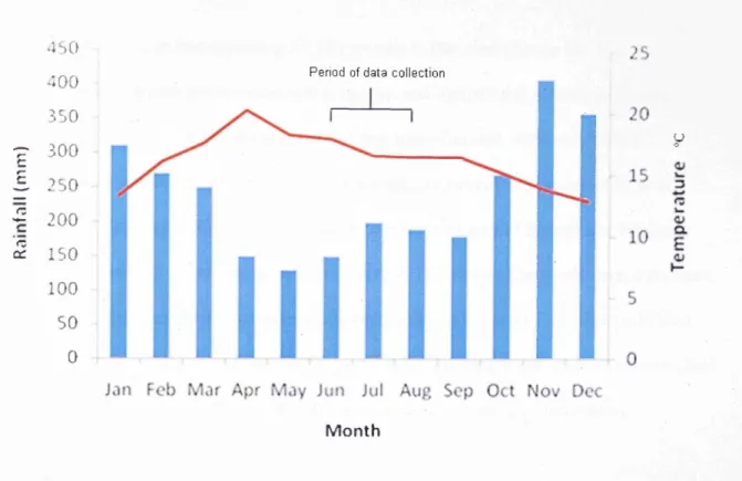
The island experiences a tropical monsoon climate with a June-Septem ber dry season and a Novem ber-A pril wet season. M ean annual rainfall ranges between 1500 - 2000mm, peaking between April and June (W hitten et al. 2002), with m ean annual temperatures o f 25 °C - 27 °C (Figure 1.6). 30 2S 3 5 0 300 250 E £ 200 IB 150 0c 100 s o 0 Period o f s tu d y collection
Jan Feb M ar Apr May Jun Jul Aug Sep Oct Nov Dec
Mont h
Figure 1.6. Monthly mean rainfall and temperature data fo r Buton Island, South East Sulawesi. Adapted from Singer and Purwanto (2006).
Much of Buton has been identified as being of high conservational value (Cannon et al. 2007), possessing a diverse flora and fauna. Catterall (1998) reported the presence on the island of at least 231 bird species including 52 Sulawesi endemics. It is also a stronghold for two species of endangered endemic bovid; the Lowland {Bubalus depressicornis) and Mountain (Bubalus quarlesi) anoa; this is one of only two locations where the ranges of both species are known to overlap, with approximately 10% of the global population of both species occurring on the island (Burton et al. 2005).
Forest cover on the islands has undergone significant clearance in recent years; Seymour (2004) describes how agricultural expansion, logging and mining activities have led to the loss of over 13% (27,809 hectares) of remaining forested areas between 1991 and 2002.
The Lambusango forest reserve was established in 1982 as part of a nationwide policy by the Suharto administration to found new national parks and reserves across Indonesia. The Lambusango was selected as one of these new reserves based on its ‘potency of flora and fauna’ and now occupies a large part of south-central Buton. Its area is divided into a 28,510 hectare strict forest reserve where all commercial, recreational and agricultural activities are nominally prohibited, and a 35,000 hectare production forest where some sustainable activity is allowed (Singer and Purwanto 2006).
The Lambusango provides an excellent study site for investigating the aims of this thesis due to its endemic-rich avifaunal community and the wide variety of forest successional stages occurring within its borders. Much of the interior of the limited production zone is highly inaccessible and has never been subject to cultivation or other significant human disturbance. Consequently high quality, near-primary forest can be found here. Much of the strict reserve’s interior, however, was settled and under cultivation prior to designation as a protected area. Settlers were progressively evicted in the 1980s and the vegetation here has had over 25 years to regenerate, providing a good example o f well-regenerated secondary
forest. W hile the strict reserve’s interior has been left largely intact since the declaration o f the reserve, m uch o f the peripherary has been inadequately regulated and there has been much encroachment from shifting cultivation and logging activities, creating a belt o f heavily disturbed secondary forest. Surrounding the reserve is a matrix o f cleared m ixed agricultural land. Photographic examples o f these habitat types are shown in A ppendix 3. This variation o f habitats provides a well-defined disturbance gradient to investigate the impacts o f
anthropogenic activities on a unique avifaunal com munity (Figure 1.7).
C le ared fa rm lan d o u ts id e re s e rv e
R e g e n e ra tin g s e c o n d a r y fo r e s t in r e s e r v e s n terio r
N ear-f r is tire p rim ary fo r e s t in
lim itec p ro d u c tio n f o r e s t Transact*
b m ite d Producfron Forest F orest R e serv e
D is tu rb e d s e c o n d a r y f o r e s t on r e s e r v e s p e rip h e ry
Figure 1.7. Forest categories and study sites within the Lambusango reserve.
1.7 - CUSUCO NATIONAL PARK
The second study site examined in this thesis is Cusuco National Park (15029.8’-15032’N / 88° 13 - 88°26’ W); a 23,440 hectare region o f tropical montane cloud forest located in Cortez province, N orth-W est Honduras, near the Guatemalan border (Figure 1.8).
2 0° ? C aribbean t Sea ' G ulf o f H o n d u ra s M exico G uate m ala H o nduras N icaragua-El S a lva d o r P acific Oces 5 0 0 km 10° Rica_ 9 0 °
Figure 1.8. Central America and Cusuco National Park.
The park occupies the central peaks of the Merendon cordillero at altitudes between 500 m - 2,242 m above sea level (Lenkh 2005). These are fairly low elevations for the occurrence of cloud forest, which is more typically found between 2000-3500m (Bubb et al. 2006). The habitat occurs here due to its proximity to the Caribbean and the effect of the Westemly Alize trade winds, which bring moisture-bearing air up the mountain slopes where it condenses into cloud banks (Bubb et al. 2006). Mean annual precipitation in the Park ranges from 2,995 mm in the core zone and 2,580 mm in the buffer zone, with heaviest rainfall occurring between October - December. Mean monthly temperatures range from 12.9°C in December to 20.2°C in April, with a mean of 16.7°C in the core and 20.6°C in the buffer zone (Fundacion
4S0 40 0 350 ■p 300 c J . 250
£
200
5 IS O100
50 0 MonthFigure 1.9. Monthly mean rainfall and temperature data fo r Cusuco National Park, Honduras. Adapted from Fundacion Ecologista (1994).
V egetation classifications within the park vary from cleared agricultural land and Pinus oocarpa pine forest at lower elevations to hardwood cloud forest and Bosque enano dw arf forest at altitudes above 2000m (Lenkh 2005) (See Figure 1.10 and A ppendix 3).
The park supports a rich avifauna with over 270 species having been recorded (M artin 2007) including several species o f a high conservation value such as the Resplendent Quetzal (Pharomachrus m ocinno) and Highland Guan (Penelopina nigra). Cusuco also provides habitat for m any other rare and endangered species, including at least six species o f endangered or critically endangered herpetofauna, four o f which are endemic to the park (Townsend et al. 2006), and small populations o f threatened large mammals, including Jaguar (Panthera onca) and Baird’s Tapir (Tapirus bairdii) (Operation W allacea 2008).
Cusuco National Park was established in 1993 following the Honduran government passing the Cloud Forest Act (1987) and General Environment Law (1993) as one o f 37 new high altitude forest reserves. The park is divided into a nom inally inviolate 7,690 hectare core zone
(Zonas nucleos) and an encompassing 15,750 hectare buffer zone (Zonas de
am ortiguam iento) where some sustainable economic and agricultural activity is permitted (Figure 1.10). However, active management o f this area is limited, with very little
conservation infrastructure and only five full-time rangers em ployed to m onitor its area (Lenkh 2005). Funding is far below that needed to govern an area o f its size and financing has decreased m arkedly in recent years (Lenkh 2005). The park is also under severe pressure from the 30-40,000 people living within the borders o f its buffer zone. The clearly defined zonation o f the park, together with its status as an undermanaged ‘paper-park’ create an ideal opportunity to assess the effectiveness o f these areas are in protecting biodiversity.
D egraded habitats typical of buffer zo n e
Pine forest found at lower altitudes on w estern slo p es
A ltitud e (m e tre s) 0-500 ||SJj 500- 1000 BM1000 -1300 ( i j 1300-1500 | I 1500 - 1800 [ 1 1800 - 2300
B osque e n a n o dwarf forest found a t highest altitudes
Moist cloud forest found in parks core
1.8 - THESIS STRUCTURE
This thesis follows the structure of ‘submission by paper’. The first two chapters are
represented by this introduction and a literature review. Each of the subsequent five chapters was initially written in the format of a peer reviewed publication corresponding to one of the four research aims previously stated, although the structure of each has been standardised into a uniform ‘thesis’ style for ease and consistency of reading.
Chapter 3: ‘Assessment of the effectiveness of two different methodological techniques for surveying cloud forest bird communities’ compares and contrasts the effectiveness o f two different census techniques, point counts and mist netting, in surveying bird communities in cloud forest; a distinctive ecosystem where little methodological research has been conducted previously. It forms an important part of the thesis by determining the most effective way to conduct avifaunal surveys in this environment as well as providing justification for the methodologies utilised elsewhere in the thesis.
Chapter 4: ‘Impacts of tropical forest disturbance upon avifauna on a small island with high endemism: implications for conservation’ describes the relationship between increasing anthropogenic disturbance and patterns of avifaunal biodiversity within the Lambusango forest reserve. It examines avifaunal communities in their entirety, range-restricted endemic species and certain key species with a high conservational importance, such as the Red- knobbed Hombill Rhyticeros cassidix. It represents a key component of the thesis by providing a detailed overview of avifaunal response across a disturbance gradient in one of the two study sites.
Chapter 5: ‘An assessment of the effectiveness of a Mesoamerican ‘paper park’ in conserving a cloud forest avifauna’ examines the effectiveness of an under-managed Mesoamerican National Park in conserving cloud forest bird species. It examines how the composition of avifaunal communities varies between the core and buffer zones of Cusuco National Park, with a strong emphasis on range-restricted and threatened species of a high conservational importance, and uses variations in bird populations to assess the park’s effectiveness in conserving biodiversity to a species level. This chapter is of significance to the thesis as it further explores the relationship between avifaunal communities and environmental disturbance, and represents one of the few extant studies evaluating the effectiveness of ‘paper-parks’ in the region.
Chapter 6: ‘Habitat associations of an insular Wallacean avifauna: a multi-scale approach for biodiversity proxies’ builds upon the research described in Chapter 3, examining
relationships between avifaunal communities and habitat structure at several spatial scales. The chapter aims to determine how best to utilise remote sensing and in-situ habitat
measurements to provide useful proxy estimates of bird community composition, with a view to facilitating the identification of priority conservation areas.
Chapter 7: ‘Differential vulnerabilities of range-restricted avifauna on a Wallacean Island and in Mesoamerican cloud forest: the influence of ecological and biogeographical factors?’ This chapter synthesis the findings of data collected across both study sites, comparing sensitivity of range restricted avifauna in these areas to habitat disturbance and providing hypothetical arguments for any differences identified.
Chapter 8 provides a conclusion summarising the findings o f the thesis as well as evaluating the research m ethods used in its production. It discusses potential further studies and research questions generated by our results.
The structure o f this thesis, along with a dem onstration o f how each chapter and research topic is interlinked, is displayed in the conceptual m odel in Figure 1.11.
0
4
Literature review Chapter 2_____
Establish overall research objectives
Explore background, concepts and identify research gaps
Methodological study Chapter 3________
Establish best methods for conducting research
Cusuco National Park Chapter 5
Main objective
Relationships between avifauna and habitat disturbance in:
Lambusango forest Chapter 4
Does a difference occur? Why?
Investigate main research aims
Synthesis o f findings in each study site
How effective are protected 1 Whatare the habitat associations of areas in conserving avifauna? ■ avifauna with high conservation importance?
Chapter 5 Chapter 6
I Conclusion 1 ^
More in-depth exploration of Issues related to main objective
Summarise research findings and identify further research
Figure 1.11- Conceptual diagram identifying research objectives, thesis structure and relationships between chapters.
Two appendix chapters summarise additional research conducted in the course of this thesis:
Appendix 1 provides an overview of the avifauna of the Lambusango Forest Reserve and its environs, including a systematic checklist of species recorded there. This provides important base-line data for this previously undescribed area.
Appendix 2 details morphometric measurements of >1500 birds captured by mist-netting surveys in Cusuco National Park between 2004-2008, which include previously unpublished, valuable data on many poorly described cloud forest species
Two further appendicies provide photographic examples of the study sites examined in this thesis, and summarise the progress of papers submitted for peer-review at the time of thesis acceptance, including details of journal titles, submission dates and publication dates.
1.9 - REFERENCES
Abrams, E.M. & Rue, D.J. (1988) The causes and consequences of deforestation among the prehistoric Maya. Human Ecology, 16, 377-395.
Achard, F., Eva, H.D., Stibig, H., Mayaux, P., Gallego, J., Richards, T. & Malingreau, J. (2002) Determination of deforestation rates of the world’s humid tropical forests. Science, 297,999-1002.
Anderson, R.S. & Ashe, J.S. (2000) Leaf litter inhabiting beetles as surrogates for
establishing priorities for conservation of selected tropical montane cloud forest in Honduras, Central America (Coleoptera; Staphylinidae, Curculionidae). Biodiversity and Conservation, 9,617-653.
BirdLife International (2004). Threatened Birds o f the World 2004. Cambridge: BirdLife International.
Blair, R.B. (1999) Birds and butterflies along an urban gradient: Surrogate taxa for assessing biodiversity? Biological Conservation, 9, 164-170.
Bonta, M. (2005) Becom ing forest, becom ing local: transform ations o f a protected area in Honduras. Geoforum, 36, 95-112.
Bray, D.B. & Klepeis, P. (2005) Deforestation, forest transitions and institutions for sustainability in South-eastern M exico, 1900-2000. Environm ent and H istory, 11, 195-223. Brooks, T.M ., M ittermeier, R.A., M ittermeier, C.G., da Fonseca, G.A.B., Rylands, A.B., Konstant, W .R., Flick, P., Pilgrim, J., Oldfield, S., Magin, G., Hilton-Taylor, C. (2002) Habitat loss and extinction in the hotspots o f Biodiversity. Conservation Biology, 16, 9 0 9 - 923.
Bruner, A.G., Gullison, R.E, Rice, R.E. & da Fonseca, G.A.B. (2001) Effectiveness o f National Parks in protecting tropical biodiversity. Science, 291, 125-128.
Bubb, P., May, I., Miles, L. & Sayer, J. (2004) Cloud fo re st agenda. Cambridge: United N ations Environm ent Program W orld Conservation M onitoring Centre.
Burton, J.A., Hedges, S. & Mustari, A.H. (2005) The taxonom ic status, distribution and conservation o f the low land anoa Bubalus depressicornis and m ountain anoa Bubalus quarlesi. M am m al Review, 35, 25-50.
Cannon, C.H., Summers, M., Harting, J.R. & Kessler, P.J.A. (2007) D eveloping conservation priorities based on forest type, condition, and threats in a poorly known ecoregion: Sulawesi, Indonesia. Biotropica, 39, 747-759.
Catterall, M. (1998) B ird survey o f Buton island 1996—1997. U npublished Operation W allacea report.
Cayuela, L., Golicher, D.J. & Rey-Benayas, J.M. (2006) The extent, distribution and fragmentation o f vanishing m ontane cloud forest in the highlands o f Chiapas, Mexico. Biotropica, 38, 544-554.
Coates, B.J. & Bishop, K.D. (1991) A guide to the birds o f Wallacea. Alderley: Dove publications.
Conservation International (2007) Biodiversity hotspots. Accessed on 10/12/07 from www.biodiversitvhotspots.org/XP/Hotspots.
Cox, C.B. & M oore, P. (2002) Biogeography: an ecological and evolutionary approach. London: Blackwell Science.
Cox, C.B. (2000) Plate tectonics, seaways and climate in the historical biogeography o f mammals. M em rias do Instituto Oswaldo Cruz, 95, 509-516.
Curran, L.M., Trigg, S.N., M cDonald, A.K., Astiani, D., Hardiono, Y.M., Siregar, P., Caniago, I. & Kasischke, E. (2004) Lowland forest loss in protected areas o f Indonesian Borneo. Science, 303, 1000-1003.
Darlington, P. (1963) Zoogeography: The geographical distribution o f animals. Cambridge: Harvard U niversity Press.
Fuller, E. (2000) Extinct birds. Oxford: Oxford University Press.
Furness R.W. & Greenwood J.D. (1994) Birds as monitors o f environm ental change. London: Chapm an and Hall.
Gardner, T.A., Barlow, J., Araujo, I.S., Avila-Pires, T.C., Bonaldo, A.B., Costa, J.E.,
Esposito, M.C., Ferreira, L.V., Hawes, J., Hernandez, M.I.M., Hoogmoed, M .S., Leite, R.N., Lo-M an-Hung, N.F., M alcom, J.R., Martins, M.B., M estre, L.A.M., M iranda-Santos, R., Overal, W .L., Parry, L., Peters, S.L., Riberiro-Junior, M.A., da Silva, M .N.F., M otta, C. & Peres, C.A. (2008) The cost-effectiveness o f biodiversity surveys in tropical forests. Ecology L etters, 2, 139-150.
Global Environm ent Facility (2005) H onduras Biodiversity in priority areas project. N ew York: Global Environment Facility.
Global Forest W atch/Forest W atch Indonesia (2002) The state o f the forest: Indonesia. Bogor: Global Forest Watch.
Goman, M. & Byrne, R. (1998) A 5000 year record o f agriculture and tropical forest clearance in the Tuxtlas, Veracruz. The Holocene, 8, 83-89.
Howard, P.C., Viskanic, P., Davenport, T.R, Kigenyi, F.W ., Baltzer, M., Dickinson, C.J., Lwanga, J.S., M atthews, R.A. & Balmford, A. (1998) Complementarity and the use o f indicator groups for reserve selection in Uganda. Nature, 394, 472-475.
Howell, S.N.G. & W ebb, S. (2005) A Guide to the Birds o f M exico and Northern Central America. 7th edition. Oxford: Oxford University Press.
Huxley, T.H. (1868) On the classification and distribution o f the A lectoromorphae and Heteromorphae. Proceedings o f the Zoological Society o f London, 1, 29-39.
Indonesian Em bassy (2009) Accessed on 10/10/09 from www.indonesianem bassv.org.uk. Kinnaird, M. (1995) North Sulawesi: a natural history. Jakarta: W allacea Developm ent Institute.
Kremen, C. (1992) Assessing the indicator properties o f species assemblages for natural areas monitoring. Ecological Applications, 2, 203-217.
Lawton, J.H., Bignell, D.E., Bolton, B., Bloemers, G.F., Eggleton, P. & Hammond, P.M. (1998) Biodiversity inventories, indicator taxa and effects o f habitat m odification in tropical forest. Nature, 391, 72-76.
Leaky, R.E. & Lewin, R. (1996) The Sixth Extinction: Patterns o f Life and the Future o f Humankind. London: Doubleday.
Lenkh, C.A.M. (2005) Cusuco fo re st m anagement report. Unpublished Operation W allacea report.