Spatial Information System in the Context of Developing Spatial
Data Infrastructure
Anthony G. Tumba
Department of Surveying and Geoinformatics Modibbo Adama University of Technology, P. M. B. 2076, Yola,
Nigeria
[email protected] Abstract
This study focuses on the spatial information system in the context of developing spatial data infrastructure, developing spatial data infrastructure in the context of this study is a spatial data infrastructure whose operational capacity does not satisfy the standards befitting of a functional or operational spatial data infrastructure. The researcher assumes spatial information system as the sum of the spatial data and spatial information obtained from a geographic information system manipulation, synthesized to give spatial information system useful for information exchange and sharing in spatial data infrastructure. Qualitative review of relevant texts and web information were used for the subjective analysis of the information obtained. The result obtained revealed a glaring gap difference in the understanding, performance and readiness of spatial information among the three geospatial communities analyzed, indicative of the context in which spatial information is held for spatial data infrastructure performance. An attempt was made to proffer requirements necessary for spatial data infrastructure.
Keywords: Spatial Information System, Developing SDI, Functional SDI, SDI Compliance 1.0 Introduction
Spatial data (SD) and spatial information (SI) are a global phenomenon that is widely talked about in the geo-spatial community. The many advances made in computer graphic technology and improved information gathering through the use of modern information communication technology (ICT) and the internet has revolutionized spatial information gathering and dissemination. Spatial information system (SIS) entails information about the metric location of artificial and natural objects on the earth’s surface that are processed into vital information for the management of human and natural resources. A good example is the fact that weather report are being processed on a daily basis from satellite imageries useful to farmers and other weather related users and businesses.
The pool of information from geographic information system (GIS) has brought to bear on global spatial information, the GIS which was started by Roger Tomlinson under the Canadian geographic information system (CGIS) has grown both in definition, design and concept (examiner.com, 2012).
The definition of SIS covers the interpretation of geographic data, to the derived or explored information inherent in a geographical location, to its uses in a non-spatial context for addresses and businesses. It involves storing information that can be retrieved, manipulated, archived, reprocessed and shared by users and stakeholders in the management of human and material resources tailored towards economic development and sustainability (AD-SDI, 2013; Bishop & Mandel, 2010; Coetzee & Eksteen, 2012; ESRI, 2013).
Spatial data infrastructure (SDI) was first used in 1993 by the United States national research council (UN-NRC) to denote institutional arrangements or framework, the necessary technology and policies conducive for the exchange of geographic information resources, for better information sharing in the geospatial community. SDI provides a basis for creative innovation and spatial data delivery mechanism to the World Wide Web via data repositories or clearinghouses. Spatial data infrastructure can be defined in the context of the users, depending on their application domain.
Research in geospatial information has seen tremendous advances in model development for application in the various fields of geospatial endeavor aimed at providing effective means of exchange and sharing spatial data. SDI as a framework for exchange and sharing has passed through; and still passing through systematic improvement in data documentation, exchange and sharing.
The first generation of SDI were ‘product’ based, while the second generation currently in use and undergoing reformation for a third, is ‘process’ based. The product based deals with the production of spatial data for exchange and sharing, applying SDIs components of people, access network, policy and standard for disseminating spatial data.
The process based SDI on the other hand deals with the process of perfecting mechanism for effective data sharing, aimed towards having an enabling environment for data sharing beneficial to spatially enabled society-a society with spatially enlightened citizens that can plan based on available spatial information (Rajabifard & Williamson, 2001; Williamson, Rajabifard, Wallace, & Bennett, 2011).
spatial information generation and dissemination, the developing SDIs do not have adequate knowledge, technology and expertise for deriving spatial information meant for SDI. Developing- SDIs in the context of this research are SDIs that do not have the capability or facilities that satisfy the global spatial data infrastructure (GSDI) requirement. Most of these SDIs are found in the developing countries of the world (Musinguzi, 2011).
Spatial information system in the context of SDI deals with the requirements of spatial data as envisaged in its application in SDI. It deals with the basic components of the product and the process of spatial data infrastructure requirements.
This research aims to analyze SIS in the context of developing SDI for information and knowledge on data exchange and sharing.
2.0 Statement of the Problem
Current trends in spatial information system deals with the automation of high quality spatial data geared towards facilitating exchange and sharing of information through standard and reliable repository or clearinghouse meant for standard SDIs for the consumption of various users and facilitators of spatial information (Rajabifard & Williamson, 2001). Modern SDI also has to sheaf for information of high quality from its lot for exchange and sharing. The context in which spatial information is treated differs based on the level of development in spatial information infrastructure (SII). The Developed SDIs are now faced with the problem of volumes of spatial data as a result of advances in GIS capabilities and computer graphic technology. Spatial information system in the developing SDIs is still at the infant stage. In spite of the efforts of governments and partnership/donor agencies, spatial information in the developing SDIs, mostly found in the developing countries still remain in ambiguity. This ambiguity is occasioned by the inability of the governments and the operating agencies to identify;
• What constitutes spatial data and spatial information?
• The standard and technological needs necessary for exchange and sharing of spatial information.
• What kind of spatial information is needed for SDI compliance?
In the context of this research, this technological gap can be filled if the negative tendencies attached to the understanding of spatial information is fully comprehended and appreciated in order make for an SDI compliant towards a sustainable spatial information system.
3.0 Overview of Spatial Information
GIS concept which started in Canada approximately 60 years ago has undergone a systematic change both in the professionals and technical capabilities (Tumba & Ahmad, 2014). This giant stride, which started as one-man-show has brought environmental scientists of different disciplines together to brainstorm on enhanced ways of producing geographic information/data that could respond to so many unanswered environmental questions. It has also experienced tremendous developments in software. Evidence abounds that individuals working independently, from different countries are instrumental to modern todays GIS (examiner.com, 2012).
The 1998 declaration of ‘digital earth’ by the then vice president of the United States, Al Gore, motivated the quest for global spatial information (Craglia et al., 2008), a spatial information system with global coverage for channeling the sharing and or exchange of spatial data at all the levels of the geospatial community (Clarke, 2011).
3.1. Spatial Information in Europe
The directive 2007/2/EC of March 2007 of the infrastructure for spatial information in Europe (INSPIRE) has over the years encouraged the research morals of European countries participating in INSPIRE initiative (UN, 2009). The directive deals with policies affecting the impact of spatial information on the environment. This is aimed at harnessing the collation and dissemination of spatial data that are interoperable, interoperability is about combining spatial datasets and its interaction without ambiguity or duplication for the management of environmental and other related problems affecting member states (Toth, Portele, Illert, Lutz, & de Lima, 2012). Thus, the maintenance of spatial information produced by each member state is the concern of INSPIRE.
INSPIRE directive 2012 deals with the implementation of the INSPIRE regulation 2009 (c), which calls for changes in the implementation of 2007/2/EC which concerns the creation and operation of national and European union infrastructure relating to spatial information for European Union (EU) environmental policies and other needs. Thus, the INSPIRE regulation 2012 for environmental protection and public sector information is a proof of systematic upgrading and effective maintenance and management of spatial information necessary for sustainable spatial information within EU member states and the geospatial community at large (EU, 2012). The INSPIRE initiative as laudable as it looks has its own challenges occasioned by interoperability problems within its SDI, uniform standards have not been achieved as a result of difficulties faced from transforming from one delivery system to another based on modern ICT technology (Abugessaisa & Ostman, 2011). The inauguration of ATLAS of INSPIRE was as a result of these challenges faced in the implementation of INSPIRE
due to the interoperability problems. The aim is to map out the challenges in the implementation of INSPIRE’s SDI standards. Governments were encouraged to float online portals to make spatial data available in exchangeable digital format for public input and participation (De Vries, Crompvoets, Stoter, & Vandenberghe, 2011; Rajabifard & Williamson, 2001). The observed trends in the developed countries, especially Europe have shown that SDI is beginning to reach the level of critical point where volumes of spatial data available due to maturity of SDI as a result of research in the field of geospatial information would translate to the era of geo-sensor- availability of spatial data at a glance (Bregt, Crompvoets, De Man, & Grus, 2009), this is an indication of the fulfillment of the requirements of the ‘digital earth’ vision 2020 (Craglia et al., 2012).
3.2.Spatial Information in Asia
Spatial information at the regional level in Asia is handled by the Asian spatial information and network analysis, under the auspices of the Australian Consortium for the Spatial Information and Network Analysis (ACASIAN). It was formerly an institute based research body founded by professor Lawrence Crissman (ACASIAN, 2012). In collaboration with individuals and other institutions, ACASIAN explore opportunities for improving spatial information base and databases of the region.
Australia’s SDI quest has come of age shown by the advances reached, not only in the provision of spatial data, but also in its availability and access. Spatial information can readily be accessed with ease from the pool of repositories provided. Australia’s SDI and indeed its spatial information abundance is a result or benefits of long term planning, the idea of e-participation in SDI at the state-local level, due to the availability of information communication technology (ICT) and the web was envisaged long ago (Yigitcanlar, 2006). Quarterly report provided reveal the rate of searches made on a specific repository domain, Search errors were an upshot of poor metadata content.
Part of the management of spatial information for Australia is this report normally provided by the Australian Spatial Data Directory (ASDD) an arm of Australian Spatial Data Infrastructure (ASDI) whose maintenance is done by Geoscience Australia on behalf of ANZLIC, the spatial data infrastructure body for Australia and the New Zealand (Tang & Lam, 2011).
Japan, China and Korea are three countries that are said to have advanced in electronic technology. Modern GIS and SDI have both changed in concept and technology, as a result of advances in computer graphic. In Japan, a prototype method of approach to spatial information is implemented where an analogous application of spatial data models in other advanced SDIs is made, and a Japan-specific model are produced for implementation in different geospatial resource sectors of the country’s economy (Muto, Tsunoda, & Kumasaka, 2010).
In China, geographic information and spatial data infrastructures is handled by the National Geomatics Center of China (NGCC), under the supervision of the China National Spatial data. The center is in charge of, maintaining, designing, developing and updating of geospatial information for the national, provincial and municipal governments (Chen & Chen, 2003). These are Imperative for solving basic problems that are of national interest, such as environmental and land resources, natural disasters and threats to human life.
Korea’s SDI case study by the Information for Development (InforDev) showed collaborative efforts meant to give lending hands to developing countries' efforts to grow their SDI capabilities (Davis Jr. , A., & Fonseca, 2011; Kim, 2011). South Korea is a country with high potential to transform its self from an aid-dependent nation to a developed one; giving her capability in advanced IC technologies.
The prospects in Malaysia for SDI are high, the task of coordinating geographic information (GI) and spatial data infrastructures lies in the Malaysia Center for Geospatial Data Infrastructure (MACGDI) an arm of (MyGDI), the Malaysia Geospatial Data Infrastructure. A comparative empirical research carried out on some developed SDIs and developing SDIs also revealed the potential of Malaysia moving towards a spatially enabled society, as a result of its position as a stable economy (Idrees, Saeidi, Yusuf, & Shariff, 2012).
3.3. Spatial information in Africa
The evolution of Africa’s spatial information cannot be written without the history of the establishment of the sub-regional spatial information centers of the seventies. Prior to this period, spatial information or to be precise spatial data in analogue formats (maps and charts) was the exclusive reserve of the exploiting colonial masters. The coming into being of the United Nations economic community for Africa (UNECA) brought about a significant change in the orientation for maps and charts desired for resources documentation and management throughout Africa. This saw the establishment of such centers as the Regional Centre for Training in Aerospace Surveys (RECTAS) in 1972 in Ile-Ife, Nigeria under the auspices of UNECA, with the mandate for research and training, advisory and consultancy services (RECTAS, 2013). RECTAS is solely an intergovernmental organization in partnership with West African countries.
The Eastern and Southern African countries jointly have a similar body, the Regional Centre for Mapping of Resources for Development (RCMRD), established in 1975. The vision is to provide an up-to-date
premier center for the provision of better information and information technology for Africa’s use and beyond (RCMRD, 2013).
Tumba and Ahmad (2014) viewed Africa’s spatial information (SI) and SDI as largely characterized by interventionist investments induced by external aids and, or individual countries’ determination amidst meager financial resources. SIS and SDI are all expensive ventures; based on perceived economic capabilities, Nigeria, South Africa and Egypt are seen as leaders in terms of available facilities on ground for geographic information knowledge and SDI knowledge acquisition (Coetzee & Eksteen, 2012).
The vast natural reserves of unexploited resources, the harsh climatic condition in some of the countries, hunger and starvation as a result of misrule and corrupt governance should be the more reason why Africa should invest more in spatial information technology.
Taking a simple comparative study of the two previously mentioned centers by going into their portals or website would reveal that the work of (RCMRD) is highly applauded; it has grown in capability for surveying and mapping, geographic information systems, remote sensing and natural resources assessment and management. It also goes into partnership on behalf of member states with the development and donor agencies (GSDI, 2013).
Based on research findings, structures have been put in place in South Africa to link people, data and metadata through community based strategy, which involves the creation of repositories or clearing house. A strong legislation has also been passed on SDI in order to make spatial data (SD) readily available and accessible for peoples’ participation and input (George, 2010; Masó, Pons, & Zabala, 2012). The Consultative Committee for Space Data Systems (CCSDS); a body with the cardinal focus of standardizing common language for expressing and describing data in order to have uniform sharing and exchange format for automated spatial data among member agencies, listed South Africa’s Satellite Application Center Republic of South Africa (CSIR) as an observer agency. The development of Ubuntu software is attributed to one of South Africa’s universities, justifying its high ratings among world universities (answersafrica, 2013; CCSDS, 2010; QS, 2012).
The nature of spatial information in Nigeria is characterized by the establishment of States’ geographic information systems in emulation of the Abuja Geographic Information System (AGIS).
The Abuja geographic information system was established in 2003 to cater for the provision of digital cadastral records and other spatial information needs of the Federal Capital Territory of Abuja (Akingbade, 2012). The thirty six states on the other hand copied from AGIS and are at various stages of implementing a state owned geographic information systems, with the sole aim of providing digital spatial information for mapping of resources and for decision support and management. These GIS outfits are under the ministry of land and survey whose initial responsibility had been general mapping and providing the teeming population with information about their land and landed property records.
At the political level of spatial information research in Nigeria is the National Space Research Development Agency (NASRDA) established by law to direct the affairs of other groups like the National Centre for Remote Sensing (NCRS), the Center for Space Science Technology Education (CSSTE) and in partnership with the Regional Center for Training in Aerospace Surveys (RECTAS) owned by West African countries, all tasked with training GIS and remote sensing experts (O. A. Ogundele & Somefun, 2008). Aside from these bodies, institutions of higher learning are also involved in the training of GIS professionals (O A Ogundele & Agbaje, 2009).
Although strides have been made for the implementation of the African Reference Frame (AFREF), a geodetic reference frame for the coordination and integration of a unified reference system for Africa’s geospatial information (Kufoniyi 2013), not much is seen on the ground. The form of production and sharing of maps of most African countries is done by map merchants who are normally on government contract lists. Standards and quality are maintained by these competing agencies that produce maps whose qualities are based on characteristic domains. The uncontrolled increase in the volume of these analogue maps, and the global agitation for a shift from shelve-based storage system to the electronic repository, has all brought to bear on the demand for spatial data for effective SIS and SDI.
Africa’s spatial information system for effective SDI according to Manisa and Nkwae (2007) is bedeviled with so many problems from maps that are still in analogue form and requires conversion to lack of grip on the basic geographic information science skills at a time when the so much talked about SDI is given global attention. It seems therefore that the SDI quest is coming at a time when the continent or to be precise, when most of the countries are not prepared for it. At this stage there is still the confusion in defining terms used in GIS and SDI (Chaminama, 2009; Manisa & Nkwae, 2007; Musinguzi, 2011; Tumba & Ahmad, 2014). SDI is capital intensive, financial independence has been studied to have effective influence on compliance to sharing of geo-information (Makumbi, 2010) which most African countries lack, and some of the models being implemented in Africa by the donor or partnership agencies do not seem to work. For example, the estimated cost of having a standard clearinghouse is put at 1.5 million pounds (Crompvoets et al., 2004) which is a significant sum in terms of budgets for some smaller African countries. The basic transformation required in
spatial information in the context of developing countries’ SDI should be that which tends to focus on system requirements for the pursuit of digital information, standards, accessibility to energy and a well pursued guarded policy for implementation. The fact being that service delivery of spatial information should be well sustained and managed towards the orderly transfer of knowledge to end users (GLOVIA, 2013; Yawson, Armah, & Pappoe, 2009)
4.0 Methodology
The research is a subjective analysis of spatial information system trends in the context of SDI, taking spatial information capabilities and readiness of the global geospatial community into consideration and applying qualitative subjective reasoning as the basis at a conclusive result.
Reviewed qualitative publications and web information served as sources of information for the research. Overview of three geospatial communities were viewed and analyzed. The choices of these communities were based on a presumed medium; high and low factor affecting the quest for spatial information/data in the affected global regions.
European spatial information system and indeed their spatial data infrastructure are presumed to be high in this case, due to their advances in spatial information acquisition skills and technology for processing this information towards its effective dissemination.
The medium choice is the Asian spatial information system which consists of the low and high, there are countries in Asia whose spatial information capability is like that of some European countries, a good example is Australia, with both government and academic institutions at the forefront of the pursuit of excellence for SDI. Others, like the counties of Malaysia are already at the doorstep of spatial information enablement for the pursuit of e-governance.
The low choice is allocated to the African sub-region as an example of the struggled and the struggling spatial information system. The struggled have reared their heads up, South Africa and perhaps Nigeria fall in the category of such group. Others fall in the group of the struggling.
These three geospatial communities were analyzed in order to arrive at spatial information in the context of developing SDIs.
5.0 Results
The result of the subjective analysis carried out on the reviewed texts showed a remarkable research gap among the three geospatial communities. European spatial information revealed a well-established spatial information base that is SDI compliant. It also revealed a systematic surgery of the entire spatial information, carried out on a regular basis for improvement in the exchange and sharing of information as indicated by the various amendments and regulations from the 2007/2/EC to the Current 2012 amendments. It has also shown flexibility in accommodating spatial data interoperability, based on the efforts being made in converting from one deliver system to another. The current direction of spatial information and spatial data infrastructure in Europe is towards the ‘process’ SDI which aims for sensitization, peoples’ participation and utilization, and the creation of knowledge infrastructures for decision support.
Asia’s spatial information system is characterized by high and low. There are those that have reached the level of spatial data enablement comparable to the European standard. Australian has shown that fit as it has a delivery system that makes spatial data readily available and accessible to the public. One other kind of characteristics identified, is the Japanese style of going for a Japan-specific prototype model. Other countries in the region are the developing-type, like the case of Malaysia that is really emerging and going towards spatial information enablement.
The characteristic of spatial information in Africa is that of individual self-determination towards the pursuit of spatial information. Despite the previously stated Geoinformation centers which are still operation, not much is seen on the ground, plugging into their websites or portals revealed, South Africa as the country with an edge over the others in terms of seriousness and readiness for SDI. Structures have been put in place to link people and data through the provision of electronic repositories (George, 2010). The case is different in Nigeria, individual states copy what is done in the federal capital territory’s Geoinformation system. The performances of these GIS outfits depend on the needs of the states and the government in power.
The sum total of other Africa’s spatial information is typically that of the low, individual countries are still struggling to convert from analogue to digital formats amidst insufficient funds and lack of technological expertise. This shows that in terms of spatial information that is SDI compliant, the misconception is still there as to what it is, what is to be done and how it should be done.
6.0 Discussion
6.1 Spatial information system and spatial data infrastructure
systematic replacement of the traditional analogue maps by digital geographic information and coordinates or location based services. These technologies facilitate the reuse of archived information which is normally stored in different formats. The different formats constitute impediments to the reuse of this information due to improper documentation, lack of consistent data and incompatibility of data sets among others. Thus, the idea of refined spatial data in an exchangeable format is the bane of spatial information systems,
Spatial data infrastructure seeks to organize this synthesized information into a standard format for exchange and sharing without duplications, in such a way that the end result is a comprehensive dataset and services. The SDI is therefore an electronic repository or a clearinghouse where serviceable information is stored.
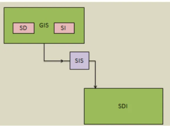
Spatial information system interaction with SDI can be viewed from the background of geographic information system. The assumption is that GIS is a mere tool that is used for the creation of digital spatial data (SD) whose attributes are stored along as spatial information (SI), the two are synthesized to form a spatial information system which interacts with SDI, a channel for exchange and delivery of refined spatial information.
Figure 1: SIS and SDI interaction 6.2 Spatial information system in the context of spatial data infrastructure
The spatial information system in the context of SDI can be looked at from the context of what constitute exchangeable and sharable spatial information. Spatial information can come in two forms, analogue and digital. On a normal traditional map, mere going through the legend gives one an impression of the information the map is trying to convey, but it is not computer-compatible in that format, though it is also spatial information since it deals with the position of objects on the earth’s surface. The traditional delivery, storage and exchange of such data are quite different from spatial data held in digital format. Digital spatial data are coded in strings of 1 and 0 and are computer-compatible; the information can be manipulated, stored, retrieved and reused. It does not require physical transportation as a means of sharing or exchange of information. Spatial information system in the context of SDI therefore, are information that is in digital format and satisfies the requirement for the exchange and sharing of spatial information held in repository or clearing house for the benefit the users- this is the SDI.
6.3 Developing spatial data infrastructures
The developing spatial data infrastructures are those SDIs whose capability to exchange and share spatial information are below the standard required of a performing SDI. Such limitations may arise due to lack of available technology, expertise, funding and lack of political willingness on the part of governments and organizations intending to have an SDI. These presented problems are not peculiar to developing SDI alone, these are mere ups and downs associated with SDI implementation (Panagiotis & Maria, 2013). In essence, SDI implementation should be followed up with periodic and systematic evaluation to cater for lapses in implementation.
6.3.1 Characteristics of developing spatial data infrastructures
Developing spatial data infrastructures (DSDI) are mostly found in developing countries. Developing countries are countries whose human development index (HDI) is low compared to others, some define developing countries based on low (GDP) gross domestic product (UNFPA, 2012; WDI, 2012). Some of these countries rely solely on external aids and assistance or partnership with donor agencies whose prescription for functional SDI are mostly ineffective. The mode of spatial data is normally in analogue format stored in traditional shelves, seeking to be converted into digital format, there is little or no awareness about the benefits or importance of spatial information to the economy of running the state.
6.4 Spatial information requirement for spatial data infrastructure
The requirement of spatial information for SDI can be viewed from the aspects of the kind of data sets, the format, interoperability of data and the availability of facilities to satisfy the requirements of the components of SDI. Datasets are the different classes of geospatial data useful for decision-making, they are normal fundamental data held either in vector or raster formats whose information are useful for planning. SDI requirement of spatial data is that they must be able to communicate between one source to another via a remote server or internet (Tooamnian, Harrie, Mansourian, & Pilesjo, 2013), this is called syntactic interoperability, an open geospatial consortium standard that enables viewing and sharing of data. Viewing data is either by web map service (WMS) whose output is a raster format or vector based graphic format whose standard for distributing spatial data is through the web feature service (WFS).
There also has to be a clear semantic interoperability of the data. It deals with the machine language in which the data must be written. It relates to the clear definition of spatial data in a way that users and systems have a common understanding of the semantics of the data. Interoperability problems in general constitute barriers to data exchange and sharing.
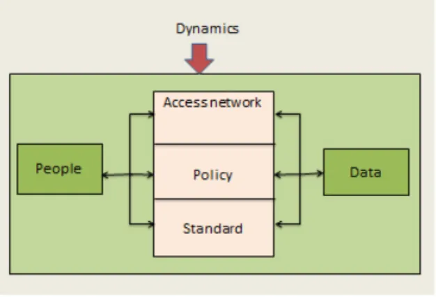
Facility requirements deal with having a functional GIS enterprise or internet-distributed GIS- which deals with a network of interconnected GIS as an avenue to address issues of public access to spatial data (Bunch, Kumaran, & Joseph, 2012) in which people, access network, policy, and standard play a vital role. According to Rajabifard et al (2001), this ‘product’ component model must be in place for a workable SDI. Motivation for users is very important, the most significant stimuli are enhanced data quality and an expected Profit on investment for better decision-making and service delivery (Sebake & Coetzee, 2013).
Figure 2: Nature and relations between SDI components (adapted from Rajabifard et al, 2001)
The above stated requirements are in the view of this research, necessary for the operation of a sustainable SDI; however it is observed that developing SDIs perception has fallen short of this reasoning. The spatial information characteristic of the developing SDIs is the formation of GIS operational outfits for the conversion of spatial data from analogue to digital formats for GIS manipulation alone. This forms the context of operation on which arguments are based, that developing countries’ SDI quest, especially in Africa, ends at workshops and conferences (Kufoniyi, Ogundele, & Baloye, 2013; Tumba & Ahmad, 2014).
6.5 Current Direction in Spatial Information System and Spatial data Infrastructure
Geographic information-knowledge and access have changed over the years, from the task of simple desktop GIS to a complex one, the maintenance of geographic data by a group of restricted numbers of technicians have also become a bygone issue (Vaccari, 2009). They have been systematically replaced by geographic information system agencies who have worked to overcome interoperability problem among users and providers of spatial information applying SDI standards and models. Current trend shows that the direction of spatial information and SDI are towards the application of ‘process’ based models of SDI (figure: 2), this model deals with capacity building and knowledge infrastructure, it channels people towards active participation in exploring the available metadata directories. It deals with creating communication awareness and facilitates coordination of SDI activities.
Figure: 3. Process based component of SDI (adapted from Rajabifard, 2001).
Recently, there has been research on finding an automated method for enhancing the usability of heterogeneous and distributed geographic datasets to mitigate the effect of data interoperability (Tooamnian et al., 2013). It was long predicted that more advanced technological ways of spatial information dissemination would one day reach a stage where data would be available as and when you need them (Craglia et al., 2012). 7.0 Conclusion
This research highlights on the spatial information system in the context of developing spatial data infrastructure. Spatial information system in the context of this research are the sum total of the spatial data and spatial information derived from a GIS necessary for exchange and sharing of vital geo-referenced information for planning and decision-making. Analysis of the spatial information capabilities of three geo spatial communities were carried out and subjected to qualitative analysis. Reviewed texts on those areas and web information provided the materials for the analysis. The result showed a striking gap in the technology, capability and spatial information readiness of the three regions, it revealed the context from which spatial information is viewed in the developing SDIs is quite different from that of the developed ones. There seems to be lack of comprehension and understanding of what constitute exchangeable and sharable spatial data with regards to data format and interoperability standard. An attempt was made to highlight on spatial information requirements for SDI which would lead to exchangeable and sharable data for better spatial information dissemination to users and stakeholders.
References
Abugessaisa, I., & Ostman, A. (2011). Testing-SDI e-Government Perspective, Requirement and Challenges.
International Journal of Public Information System, 1, 11-47.
ACASIAN. (2012). Asian Spatial Information and Analysis GIS Data for China, South-East Asia, Soviet Union. [Online]. Available: http://acasian.com/. [April, 20 2014].
AD-SDI. (2013). Abu Dhabi Spatial Data Infrastructure, United Arab Emirate. Website of ADSDI. [Online]. Available: http://sdi.abudhabi.ae/Sites/SDI/Navigation/EN/faqs,did=80826,fragmentnr=2.htm. [July,29 2013].
Akingbade, A. O. (2012). E-land administration in the context of e-government in Africa: An evaluation of Nigeria’s Abuja Geographic Information Systems (AGIS). (PhD), University of Twente, The Netherlands.
Answersafrica. (2013). Top 10 Most Technologically Advanced Countries in Africa - Answers Africa. [Online].
Available: http://answersafrica.com/top-10-most-technologically-advanced-countries-in-africa.html.
[Agust, 1 2013].
Bishop, B. W., & Mandel, L. H. (2010). Utilizing geographic information systems (GIS) in library research.
International Journal of Geographic Information System, 28(4), 536-547. doi: 10.1108/07378831011096213
Bregt, A., Crompvoets, J., De Man, E., & Grus, L. (2009). Challenges in Spatial Data Infrastructure research: a role for transdisciplinarity? . GSDI 11 Spatial Data Infrastructure Convergence : Building SDI Bridges to address Global Challenges, Rotterdam, The Netherlands, 15- 19 June, 2009.
Bunch, M. J., Kumaran, T. V., & Joseph, R. (2012). Using Geographic Information Systems (GIS) For Spatial Planning and Environmental Management in India: Critical Considerations. International Journal of Applied Science and Technology, 2(2).
CCSDS. (2010). The Data Description Language East Specification (CCSD0010). ccsds publication. [Online]. Available: http://public.ccsds.org/publications/archive/644x0b3.pdf. [July, 12, 2013].
Chaminama, N. (2009). Analysis of Public Sector Cooperation and Geoinformation Sharing: A resource dependence perspective, Msc. International Institute for Geo_information Science and Earth Observation, Enschede, The Netherland.
Chen, J., & Chen, X. (2003). Development of National Spatial Data Infrastructure (NSDI) in China: Progress and Applications. Journal of Geospatial Engineering The Hong Kong Institution of Engineering Surveyors, 5 (2).
Clarke, D. (2011). Initiatives and Challenges of SDI in South Africa. Processing Technical: National Geo-spatial Information, South Africa. PositionIT_nov-dec11-Pro_33-35_2, 2011.
Coetzee, S., & Eksteen, S. (2012). Tertiary Education Institution in Africa: Cloudy with a Chance of GI SC Education in some Countries. South African Journal of Geomatics, 1 (2).
Craglia, M., de Bie, K., Jackson, D., Pesaresi, M., Remetey-Fülöpp, G., Wang, C., . . . Woodgate, P. (2012). Digital Earth 2020: towards the vision for the next decade. International Journal of Digital Earth, 5(1), 4-21. doi: 10.1080/17538947.2011.638500
Craglia, M., Goodchild, M. F., Annoni, A., Camara, G., Gould, M., Kuhn, W., . . . Parsons, E. (2008). Next-Generation Digital Earth∗ A position paper from the Vespucci Initiative for the Advancement of Geographic Information Science. . International Journal of Spatial Data Infrastructures Research, 3, 146-167. doi: 10.2902/1725-0463.2008.03.art9
Davis Jr. , A., C., & Fonseca, F. (2011). National Data Spatial Infrastructure: The Case of the Brasil. [Online]. Available: http://www.infodev.org/publications. [July, 7 2013].
De Vries, W. T., Crompvoets, J., Stoter, J., & Vandenberghe, I. (2011). Atlas of INSPIRE- Evaluating SDI Development through an Inventory of INSPIRE Experiences of European National Mapping Agencies
International Journal of Spatial Data Infrastructures Research, 6, 126-144. doi: 10.2902/1725-0463.2011.06.art6
ESRI. (2013). What is a Geographic Information System (GIS). [Online]. Available: http://www.esri.com/what-is-gis/overview#top_five_panel. [July 13, 2013].
EU. (2012). Environmental Protection Public Sector Information: The INSPIRE (Amendment) Regulations 2012.
[Online]. Available: http://www.legislation.gov.uk/uksi/2012/1672/pdfs/uksi_20121672_en.pdf.
[March, 7 2014].
examiner.com. (2012). Interview with Esri's Jack Dangermond Landscape Architecture and GIS history,
National Landscape Architecture. . Retrieved 4th, July, 2013, from
http://www.examiner.com/article/interview-with-esri-s-jack-dangermond-landscape-architecture-and-gis-history
George, J. (2010). Efforts and Activities to make Data Accessible through Development of National Geospatial
Data Clearinghouse. GSDI 12 Conference I Singapore 2010 WORKSHOP PS 1.1c.
GLOVIA. (2013). Implementation Method: Simplified Implementation with Maximized Region of Interest. [Online]. Available: http://www.glovia.com/pdf/datasheets/GloviaImplementationMethodology.pdf. [Agust, 10 2013].
GSDI. (2013). Spatial Data Infrastructure- Africa Newsletter, February_2013. The Geo-Spatial Community, 12
(2).
Idrees, M. O., Saeidi, V., Yusuf, Y. A., & Shariff, A. R. M. (2012). Comparing Approaches and Strategies for NSDI Implementation Between the Developed and Developing World. Article under Review for the International Journal of Spatial Data Infrastructures Research.
Kim, E. H. (2011). National Spatial Data Infrastructure: The Case of Republic of Korea [Online]. Available: http://www.infodev.org/publications. [September, 7 2013].
Kufoniyi , O. (2013). Building on Geospatial Information Capacity for Sustainable Development in Africa. FIG
Working Week 2013 Environment for Sustainability Abuja, Nigeria, 6 – 10 May 2013.
Kufoniyi, O., Ogundele, O. A., & Baloye, D. O. (2013). Spatial Data Infrastructure (SDI). Journal of Sustainable Development in Africa, 15(3).
Makumbi, H. (2010). Investigating the Influence of Resource Dependencies on Compliance to National Policies
of Geo-information: A Resource Dependence Perspective in Uganda
(Msc), International Institute for Geo-information Science and Earth Observation, Enschede, The Netherland., Enschede, The Netherland.
Manisa, M., & Nkwae, B. (2007). Developing Botswana Spatial Data Infrastructure: From Concept to Reality.
FIG Working Week: Hong Kong SAR, China, 13-17 May 2007.
Masó, J., Pons, X., & Zabala, A. (2012). Tuning the second-generation SDI: theoretical aspects and real use
cases. International Journal of Geographical Information Science, 26(6), 983-1014. doi:
10.1080/13658816.2011.620570
Musinguzi, M. (2011). A Tree Model for Diffusion of Spatial Data Infrastructures in Developing Countries. [Online ]. Available: http://mak.ac.ug/documents/Makfiles/aet2011/Musinguzi_I.pdf. [July, 17 2013].
Muto, M., Tsunoda, T., & Kumasaka, F. (2010). Development of Marine Spatial Data Infrastructure in Japan.
Japan Hydrographic Association. Retrieved 19th, July 2013, from http://www.gsdi.org/gsdiconf/gsdi12/papers/86.pdf
Ogundele, O. A., & Agbaje, G. I. (2009). Evaluation of Stakeholders Perception of Nigeria NGDI Using Technological Frame Theory.
Ogundele, O. A., & Somefun, O. S. (2008). SDI: Prospects and Challenges for Federal,States Developing
Countries ( case of Nigeria) The International Archives of the Photogrammetry, Remote Sensing and
Spatial Information Sciences. Vol. XXXVII. Part B4. Beijing 2008.
Panagiotis, T., & Maria, P. ( 2013). Greek National Spatial Data Infrastructure: Attempts towards Design and Implementation. International Journal of Spatial Data Infrastructures Research, 8 21-42. doi: 10.2902/1725-0463.2013.08.art2
QS. (2012). World University Rankings. [Online]. Available: http://www.topuniversities.com/university-rankings/world-university-rankings/2012 [August, 4 2013].
Rajabifard, A., & Williamson, I. P. (2001). Spatial Data Infrastructures: Concept, SDI Hierarchy and Future Directions Geomatics’ 80 Conference, Tehran, Iran, 2001.
RCMRD. (2013). Regional Centre for Mapping of Resources for Development (RCMRD) Overview _ LinkedIn. [Online]. Available: http://www.linkedin.com/company/regional-centre-for-mapping-of-resources-for-development-rcmrd- [April, 10 2014].
RECTAS. (2013). Regional Centre For training in Aerospace Surveys. from http://www.un-spider.org/sites/default/files/RECTAS.pdf
Sebake, M. D., & Coetzee, S. (2013). Address Data Sharing: Organizational Motivators and Barriers and their Implications for the South African Spatial Data Infrastructure. International Journal of Spatial Data Infrastructures Research, 8, 1- 20. doi: 10.2902/1725-0463.2013.08.art1
Tang, C., & Lam, L. (2011). Benchmarking Spatial Data Infrastructure Development in Hong Kong. FIG Working Week: Bridging the Gap between Cultures Marrakech, Morocco, 18‐22 May 2011.
Tooamnian, A., Harrie, L., Mansourian, A., & Pilesjo, P. (2013). Automatic integration of spatial data in viewing services. Journal of Spatial Information Science(6), 43-58. doi: 10.5311/josis.2013.6.87
Toth, K., Portele, C., Illert, A., Lutz, M., & de Lima, M. N. (2012). A Conceptual Model for Developing Interoperability Specifications in Spatial Data Infrastructutre. Eurpean Commission Joint Research Centre Report. doi: 10.2788/21003
Tumba, A. G., & Ahmad, A. (2014). Geographic Information System and Spatial Data Infrastructure: A
Developing Societies’ Perception. Universal Journal of Geoscience, 2(3), 85-92. doi:
10.13189/ujg.2014.020301
UN. (2009). United Nations Group of Experts on Geographical Names: Working Paper No. 34 Twenty-fifth session Nairobi, 5–12 May 2009. from http://unstats.un.org/unsd/geoinfo/ungegn/docs/25th-gegn-docs/wp%20papers/wp34-inspire-germany.pdf
UNFPA. (2012). Population Trends Rapid Growth in Less Developed Regions Population & Development
Linking Population, Poverty and Development http://www.unfpa.org/pds/trends.htm ( accessed 06/08/2013 ).
Vaccari, L. (2009). An Evaluation of a Distributed Semantic Matching Framework. (PhD), University of Trento,
Trento.
WDI. (2012). World Development Indicators The World Bank: International Bank for Reconstruction and
Development,Green Press Initiative, USA.
Williamson, I., Rajabifard, A., Wallace, J., & Bennett, R. (2011). Spatially Enabled Society [FIG Working Week 2011, Marrakesh, Morroco: Bridging the Gap between Cultures.
]. FIG Working Week : Bridging the gap between Cultures Marrakech, Morocco, 18-22 May, 2011.
Yawson, D. O., Armah, F. A., & Pappoe, A. N. M. (2009). Enabling Sustainability: Hierarchical Need-Based Framework for Promoting Sustainable Data Infrastructure in Developing Countries. Sustainability 2009, 1, 1(4), 946-959. doi: 10.3390/su1040946.
Yigitcanlar, T. (2006). Australian Local Governments Practice and Prospects with Online Planning