High-Throughput Geocomputational
Workflows in a Grid Environment
Jia Liu, Institute of Remote Sensing and Digital Earth, Chinese Academy of Sciences
Yong Xue and Dominic Palmer-Brown, London Metropolitan University
Ziqiang Chen and Xingwei He, Institute of Remote Sensing and Digital Earth, Chinese Academy of Sciences
A grid-computing platform facilitates
geocomputational workflow composition
to process big geosciences data while fully
using idle resources to accelerate processing
speed. An experiment with aerosol optical
depth retrieval from satellite data shows a
25 percent improvement in runtime over
a single high-performance computer.
geoscientists have assembled
massive amounts of digital infor-
mation with spatial attributes,
which—when combined with the extreme complexity of open geo- spatial problems—has motivated geocomputation. Geocomputation is a discipline that exploits compu- tational advances to solve a variety of problems in integrating and ana- lyzing Earth system data. Geocom- putational workflows, particularly those in the retrieval of quantita- tive remote-sensing data, consist of several subworkflows that contain data dependencies and are both data
and computing intensive.2,3
Grid computing, already an attractive environment for
devel-T
echnological advancements and their globaldissemination are often predicated on the inte- gration of traditionally separate fields, such as geoscience and computer science, to obtain fresh approaches for solving complex problems, such as efficiently processing data about a highly integrated Earth system, which comprises subsystems that cover interlinked aspects of the Earth’s hydrosphere, atmo- sphere, and geological
composition.1 Geographers and
oping and running large-scale applications in domains other than geoscience, is a potential solution for pro- cessing these workflows, which are characterized by volumes of spatiotemporal data. The grid environment provides standardized access to a pool of heteroge- neous and distributed resources, creating the illusion of a powerful computer that can break down the data- processing bottleneck characteristic of large-scale remote-sensing applications.
Despite grid computing’s potential use in these applications, little work has focused on adapting it to this context. To address that need, we developed the Remote Sensing Information Service Grid Node (RSSN)—a high-throughput
geocomputational grid-computing
environment based on the HTCondor (formerly Condor; http://research.cs .wisc.edu/htcondor/description.html) system—which increases an individual computer’s processing power by
›
accelerating and facilitating theretrieval of aerosol optical depth (AOD) data (which measures the extent to which atmospheric par- ticles extinguish solar radiation) through a GUI that lets users compose, submit, and execute workflows;
› fully exploiting idle computing
resources; and› using workflow-optimized
scheduling and execution.retrieval from satellite data and could be a promising solution for other prob- lems related to high-throughput geo- computation, such as retrieving the temperature of land surfaces and cal- culating the albedo (surface reflectivity measure) and leaf-area index.
COMPUTING IN THE
GRID ENVIRONMENT
Geocomputational workflow in the grid environment has many challenges. The main one is that these workflows, par- ticularly those in quantitative remote- sensing applications, typically require data with varying time steps and resolu- tion. For example, the same application might require a 10-year AOD dataset at 1-km resolution from the Moderate Res- olution Imaging Spectrometer (MODIS) satellite sensor’s data—29 terabytes
This challenging mix of data and computational intensity is at the root of other issues, such as model organiza- tion, accelerating distributed process- ing, workflow-related problems, and resource scheduling. Progress in solv- ing all these issues is apparent, but open problems remain.
Model organization
Efficiently and automatically organiz- ing and executing numerous prepro- cessing and inverse models is essential to handling the mix of computational intensity and big data within an applica- tion. To enable the calculation of myriad geophysical parameters including the aerosol content for each observation— oxygen, carbon dioxide, particle mat- ter, and so on—the MODIS Adaptive Processing System generates nearly 2.5
To validate RSSN’s feasibility, we retrieved a year’s worth of AOD data to evaluate the workflow composition, workflow task-execution performance, and time-series dataset generation for AOD data retrieval and
THE GRID PROVIDES ACCESS TO
HETEROGENEOUS AND DISTRIBUTED
RESOURCES TO BREAK DOWN THE DATA-
PROCESSING BOTTLENECK.
processing. We chose AOD retrieval because it is both a computing- and data- intensive application.
We also compared RSSN’s per- formance with that of a single high- performance computer, which scien- tists typically use daily in the retrieval of remote-sensing image data. Our results show that overall runtimes decreased 25 percent over runtimes with the high-performance computer. These results imply that RSSN can sig- nificantly facilitate and accelerate AOD
(Tbytes) of original data—as well as a 30-year AOD dataset at 0.1-degree resolution from the National Oceanic
and Atmospheric Administration’s
(NOAA’s) Advanced Very High Resolu-tion Radiometer (AVHRR) data—100
Tbytes of original data.4 Not only does
the volume differ between datasets, but each dataset involves disparate processing time. Thus, efficient data management must not only address throughput but also select the appro- priate computing mode.
Tbytes of land, atmospheric, and oce-anic geophysical parameters daily on a combination of supercomputers and
commodity Intel Pentium processors.5
Accelerating data acquisition
and distribution
Complexities associated with the com- bination of data volume and variety and computational intensity can sig- nificantly delay data acquisition and distribution. Several research groups have proposed solutions that use grid
computing to mitigate these delays. Taries.net, for example, is a model that uses a distributed system built on grid computing’s basic principles to process
images from remote-sensing
observations.6
The GiSHEO platform (on-demand grid services for higher education and training in Earth observation) uses grid and Web services technologies to process remote-sensing data for train- ing quantitative data–retrieval
mod-through an infrastructure that relies on both grid and cloud computing.
HTCondor is open source soft- ware developed by the Center for High Throughput Computing at the Univer- sity of Wisconsin–Madison to support high-throughput computing on large collections of computing resources with distributed ownership. One research group used HTCondor to support the validation of a data-placement strat- egy in applications with big data and
and computational workflows,10 which
proved effective in rapidly processing, distributing, and sharing massive num-
bers of remote-sensing images.11
Another approach to solving delays in remote-sensing data acquisition and distribution is the grid-enabled paral- lel
algorithm of geometric correction
(GPGC), which computes an irregular local output area. The area allows the system to change the parallel method’s frequent and fine-grained communica- tion mode to a delayed but concentrated
communication-exchange mode.12 By
enabling geometric correction and
min-SCIENTIFIC WORKFLOW TECHNOLOGY
ENABLES THE COMPOSITION AND
EXECUTION OF COMPLEX ANALYSIS ON
DISTRIBUTED RESOURCES.
imizing communication or synchroniza- tionduring time-consuming resampling, GPGC effectively supports ChinaGrid, a project sponsored by the China Min- istry of Education to provide high- performance services in a grid comput- ing environment.
els for Earth observation.7 GiSHEO
consists of a processing-services com-
ponent, which comprises the machine interface (visible as a Web service) and workload management system, as well as data-management, workflow- engine,
user-interface, and e-learning
components.
Another effort to accelerate data distribution is the Namibia SensorWeb Pilot Project, an international multi- disciplinary initiative to create a test- bed for evaluating and prototyping key technologies suchas SensorWebs, grids, and computational clouds, to enable the rapid data product acquisition and dis-
tribution to support flood monitoring.8
The system provides access to real- time data about rainfall estimates and forecasts of flood potentials, and can rapidly generate flood maps. Computa- tional and storage services are enabled
intensive computation, such Montage, which generates science-grade mosaics of the sky.9 The goal is to demonstrate that, by combining the functionality of the data-replication service for data placement and the Pegasus system for workflow management, data-intensive workflows can execute faster with asyn- chronous data placement than with on- demand data staging by the workflow- management system. Pegasus relies on HTCondor’s DAGMan workflow engine to launch tasks and maintain intertask dependencies.
Another effort used HTCondor to establish a system for processing Earth observation images from remote sen- sors that integrated components such as the Virtual Data Toolkit and the Globus Toolkit. Integration enabled structural biology researchers to securely share large volumes of data
Streamlining scientific workflow
Not all applications require an expert understanding of remote-sensing data, and demand is growing for the ability to immediately retrieve simple and easily understood information from remotely sensed data that has already undergone complex processing and analysis.To meet this demand, researchers have attempted to apply workflow com- position and management technology in a grid environment. Scientific work- flow technology has become essential in
many applications, enabling the
composition and execution of complex analysis on distributed resources.
Grid computing with workflow tech-
nology has four main advantages:13
› it provides a composition func-
tion for grid applications;Remote-sensing grid components layer Remote-sensing data index/access controller Remote-sensing workflow composer Remote-sensing algorithm/model base Remote-sensing grid portal
› it uses local resources, thereby
increasing throughput and reduc- ing implementation cost;› it provides users with special-
purpose processing and task solv- ing across multiple management areas; and›
it promotes interorganizationalcooperation.
The technology life cycle includes workflow composition and represen- tation, the creation of data models, the mapping of modeling concepts
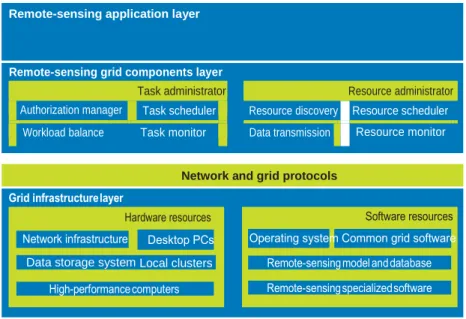
FIGURE 1. RSSN’s three-layer architecture. The layers ensure that remote-sensing infor-
mation is communicated within components in the simplest form and as rapidly as possible. The network and grid protocols are middleware services to support a common set of appli- cations in a distributed network environment.
into an executable representation, and
execution-model creation. Although
many business workflow–management systems exist, they lack features and characteristics that are essential in sci- entific applications. Special dynamic workflow management for quantita- tive remote sensing is still nascent.
Efficient resource scheduling
Scheduling is a key issue in applications with big data and high computational demands. Most grid scheduling algo- rithms are based on heuristic schedul- ing, which usually takes computing- capability parameters—the number of CPU cores and CPU clock speed, for example—as the workload vector. Data transfer is largely ignored. With addi- tional considerations such as workflow model, scheduling criteria and pro- cess, and resource and task model, grid scheduling becomes even more chal- lenging and complicated.In documenting a study of the relationship between asynchronous
data placement and scheduling,14 the
authors suggested that combining data scheduling and computation is an effec- tive solution for performance problems in data-intensive grid computing.
Another group that studied data placement and scheduling in a grid environment, proposed placing data before computation execution. They also proposed a method to combine data placement and workflow
manage-ment,9 but their method applies only to
the lightweight data replicator service and workflow mechanism in Pegasus (http://pegasus.isi.edu).
A dedicated data scheduler, Stork,15
considers data placement as the highest- priority operation, efficiently queu- ing, scheduling, and monitoring data- transmission services. Experiments show that Stork enhanced the data- transmission service’s efficiency and fault tolerance and reduced the depen- dence on user interaction in a complex data-transmission application. One dis- advantage, however, is that Stork does not support the Windows OS.
RSSN: HIGH THROUGHPUT
AND EFFICIENT SCHEDULING
RSSN aims to address the specific problems of applying grid computing solely to acquire and distribute remote- sensing data, such as the need for faster throughput and more efficient schedul- ing that uses idle computer resources fordata-intensive computing applications. We developed RSSN using HTCondor running on a Windows system. RSSN’s computing nodes are commodity PCs used in daily scientific work.
Architecture and task processing
Figure 1 shows the RSSN architecture. At the bottom is the grid infrastruc- ture layer, which includes the softwareand hardware entities. The remote-
sensing grid components layer includes task and resource monitors, the task scheduler, resource discovery, and data transmission—all to support the
remote-sensing application layer at the top. The application layer packages the lower-layer functions and supports the sharing and servicing of remote-sens- ing information. The grid middleware is HTCondor, which serves as the local resources manager to construct RSSN.
We designed RSSN so that compo- nents within each layer can share char- acteristics and thus can build on any lower-layer capabilities and behaviors.
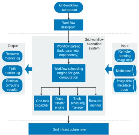
Figure 2 shows the task and process- ing flow in RSSN:
› Users compose workflows
through the grid workflow Remote-sensing application layerNetwork and grid protocols
Data storage system Local clusters
Task administrator
Authorization manager Task scheduler Workload balance Task monitor
Resource administrator
Resource discovery Resource scheduler Data transmission Resource monitor
FIGURE 2. Task and processing flow in RSSN. Through the GUI (above upper dashed line),
users compose workflows and submit them for execution. Scheduling is handled by the grid-task dispatcher, data-transfer engine, task-scheduling manager, and resource moni- tor. The workflow execution system feeds into the grid infrastructure layer, which powers its functions.
FIGURE 3. Workflow composition in RSSN. The user has composed a workflow for AOD
retrieval through the GUI by dragging icons from a list displayed to the left of the composition area. The icons represent data type, data and processing models, and corresponding algo- rithms. RSSN converts the graphical workflow to an XML file, which it uses to communicate with the webserver about the users’ workflow information.
composer GUI, selecting and defining models and data types.
› Users submit the composed
workflows and RSSN’s workflow parsing service extracts task, data parameters, and depen- dency information on the basis of the model base and image-data metadatabase.
› RSSN generates executable
workflow by parsing results and executable model programs. The workflow-scheduling engine determines task scheduling and binds the task with resources.› The grid task dispatcher and data
transfer components dispatch tasks and remote-sensing image data to grid-computing resources.
Workflow composition
RSSN’s GUI facilitates the composition of remote-sensing workflows by allow- ing users to fully employ CPU resources that typically remain idle on scientific
computers for daily work.16 The main
aspects of workflow composition are data structure, model management, the actual composition, and its parsing.
Workflow composition and parsing.
RSSN uses the Apache Tomcat (http:// tomcat.apache.org) webserver, and a Java-programmed Web application. Fig- ure 3 shows the GUI, which is display- ing an AOD retrieval workflow.
Although the workflow composer runs on the client computer, RSSN generates a socket connection, which it uses to communicate the workflow, converted to an XML workflow descrip- tion file, to the webserver. The workflow parse component analyzes the XML file to obtain task information, parame- ters, and dependencies and generates
executable programs according with HTCondor rules. Once the task monitor receives the XML file, the parsing com- ponent submits the analysis results to the HTCondor pool.
Data structure and model manage-
ment. At present, RSSN processes ras-
ter data and uses the Oracle relational database to manage it, storing image data in the file directory and managing the data path and other metadata infor- mation in the database. RSSN uses the directed acyclic graph data structure, which includes two lists.16 The nodes
list saves the remote-sensing algo- rithm’s quantitative information, such as the source data’s spatial resolution and latitude and longitude ranges. The nodes list also includes user-specified parameters that guide the tasks’ par- allelization. The relationship list notes
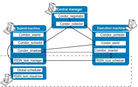
FIGURE 4. Workflow scheduling and execution mechanism extended from HTCondor.
Elements in the dashed box are specific to RSSN.
dependencies among algorithms. The Oracle relational database man- ager manages model and algorithm metadata and information such as the executable algorithms path—all of which are registered in the data- base. Database tables are divided into model tables and relevant algorithm
tables, which include the Algorithm_
Info, Algorithm_Semantics, Algorithm_
Inputs, and Algorithm_Outputs tables.
Workflow scheduling
and execution
Figure 4 shows RSSN’s workflow sched- uling and execution mechanism, which is an extension of HTCondor’s approach. RSSN uses HTCondor’s Classified Adver- tisements (ClassAds) mechanism to match machines and tasks.
Subtask creation and matching. Workflow scheduling starts when the
global scheduler accesses data nodes to request the data list. It then analyzes the workflow script and data list and divides the entire user task into sub- task packages. Each subtask package is described by ClassAds; HTCondor uses the description to match tasks with available machines. During remote- sensing data transmission, which can occur at any time, RSSN records the network bandwidth between comput- ing nodes and the data server, as well as the task execution success rate, idle time, and other aspects of computing node status. It then summarizes the recorded information and registers it as additional attribute data in HTCondor’s task scheduling configuration file, in essence expanding ClassAds attributes. The RSSN task manager submits the subtask packages to the HTCondor pool. If there is a match, the task manager sends the task packages to the matched
machine for execution. Once the exe- cuting machine receives the task pack- ages, the RSSN task manager starts the local task scheduler to process the task package. During the local scheduler’s working cycles, the RSSN task manager monitors the nodes’ workloads and other status aspects while periodically checking the job and machine lists for potential new matches.
The cycle-scheduling time span should be based on the expected data- transfer time. For example, in our AOD retrieval experiment, we found that the average file size of a subtask package is about 200 Mbytes—about a 20-second data-transfer—so sched- uling time should not be less than 20 seconds.
Subtask scheduling. When the
local scheduler receives the sub- task packages, it queues them as
Condor_starter
first-come-first-served and generates two job lists: one for each package’s data transmission task and one for the com- puting task.
In general, there is no dependency between input data to the subtask
pack-to the user. The local task manager can reschedule the failed task package.
Parallel scheduling and execution
Remote-sensing application work-
flows generally have subworkflows
computing error. When the task exceeds the threshold, the RSSN task manager will reschedule the corre- sponding subtasks.
CASE STUDY: AOD RETRIEVAL
AOD is a significant parameter in remote-sensing data because it reflects aerosol optic properties, which provideTO IMPROVE CPU AND BANDWIDTH USE,
CURRENT-PACKAGE DATA TRANSMISSION
OCCURS SYNCHRONOUSLY WITH
PREVIOUS-PACKAGE TASK EXECUTION.
insights into many scientific concerns, such as aerosol radiative forcing (the difference in sunlight absorbed and energy released back into the atmo- sphere), cloud microphysics, and atmo- spheric correction of satellite images. AOD retrieval over a long operational period involves big data and compli-ages and the intermediate results from
each computational step. Thus, while the computing task in the previous sub- task package is running, the RSSN task manager schedules data transmission for the current package synchronously. The result is improved CPU and net- work bandwidth use and a shorter over- all task-execution time.
Submitting results. As soon as the subtask running on the computing node completes, the RSSN task man- ager sends the result to the machine that submitted the workflow composi- tion. The task monitor running on the user’s
machine collects the subtask package information; the result might need to be organized together auto- matically if necessary.
Rescheduling failed tasks. The local scheduler also monitors the entire scheduling and execution process. If any part of the process fails, the sched- uler will record the package number and error message, discard the corrupt intermediate data, and send the log file
that could be scheduled and executed in parallel in a coarse-grained pat- tern. RSSN implements this approach by adding an agent layer between the webservers and computing pool. The workflow-parsing component ana- lyzes XML files and generates execut- able programs for each subworkflow, which it submits to agents—comput- ers that handle subworkflows in the HTCondor pool. The agents gather the submitted subworkflow tasks after tasks they complete.
The main idea is to collapse the pre- processing stage and reduce the over- head from the I/O of one submission machine by adding agents that work in parallel as submission machines.
Fault-tolerance mechanism
At present, RSSN supports fault toler- ance by relying on HTCondor’s middle- ware, which provides a process check- point and a mechanism to migrate failed processes by assigning a unique global ID for each computing task, and by setting a time threshold for task suspension because of an unexpectedcated processing, so retrieving data with high precision and resolution remains difficult and time-consuming.
Retrieving AOD from a satellite, such as MODIS, eliminatestheneedto prepro- cess data, but requires organizing many workflows. To date, research in AOD retrieval has focused more on exploring algorithms and less on exploring how to organize and reuse geocomputational workflows in a way that would acceler- ate computing and fully use available computing resources.
To examine how RSSN supports workflow organization, we retrieved a year of MODIS satellite AOD data from over China and evaluated how RSSN facilitated workflow organization from three perspectives: workflow composi- tion, task-execution performance and time-series dataset generation.
Workflow composition
We used the Synergic Retrieval of Aero- sol Property MODIS (SRAP-MODIS)
algorithm17 to retrieve AOD data and
RSSN’s GUI to compose the workflow shown in Figure 3. We selected models,
Inversion Mosaic and partition Preprocessing
defined the data time and data type, chose supporting algorithms, and added dependencies between models. We saved the workflow as an XML file and submitted it to the webserver for parsing and execution in the HTCondor computing pool.
Execution performance
We used data from January 2008 (while the satellite was over China), which we acquired from the National
Aeronautics and Space
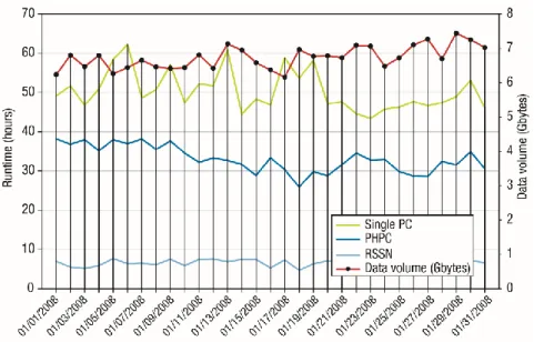
Administration’s Distributed Active Archive Center, to produce AOD at 1-km resolution. We processed the data on a single computer, on a personal high-performance computer (PHPC), and on RSSN. Figure 5 shows the results for each day.
The single PC took from 43.5 to 62.5 hours to process daily AOD data, with an average time of 50 hours. The PHPC with no modification to the pro- grams provided by scientific research- ers took from 25.9 to 38.2 hours, with an average of 33 hours. RSSN with optimizing scheduling and execu- tion took only 4.3 to 7.6 hours, with an average of 6.4 hours.
We were also interested in testing performance with a coarse-grained pat- tern of parallel subworkflows, so we selected several sample days and per- formed the improved AOD retrieval pat- tern. Figure 6 shows the results, which isolate three stages: preprocessing, cre- ating the image-data mosaic and par- titioning it, and inverting the data. For the four samples of daily AOD retrieval, the preprocessing stage with coarse- grained parallel subworkflows (left bars) reduces the original runtime (right bars) by 20.81, 39.74, 51.54, and 59.41 percent.
The mosaic and partition stages also took less time with a 42.27, 40.14,
FIGURE 5. Time to process the Synergic Retrieval of Aerosol Property (SRAP)-MODIS
algorithm in different computing environments during January 2008. The single PC is a computer with an Intel Core i5-3450 CPU running at 3.1 GHz with four cores and 4 Gbytes of memory. PHPC represents the Sugon PHPC200, a personal high-performance computer equipped with two dual-route Intel 5600 multicore computing modules.
12.00 10.00 8.00 6.00 4.00 2.00 0.00 02-01-2012 05-31-2012 08-15-2012 08-25-2012
FIGURE 6. Sample results of AOD retrieval with (left bars in each pair) and without (right
bars in each pair) a coarse-grained pattern of subworkflows running in parallel. The length of all three stages—preprocessing, creating the mosaic and partitioning the data, and invert- ing the data to solve the equations—is the total runtime in each case, which is consistently and often dramatically lower with parallel execution.
R u n tim e (h ou rs)
G
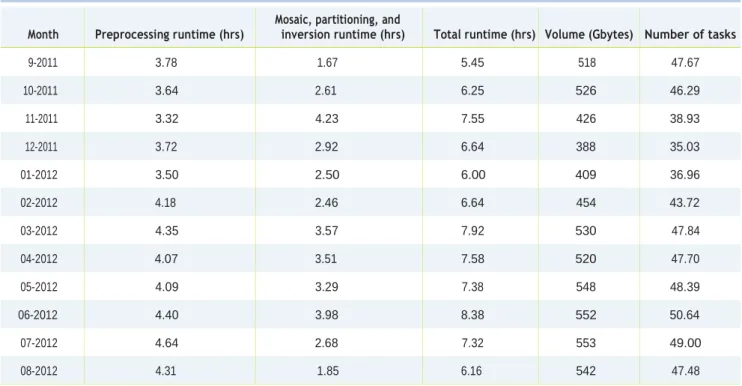
TABLE 1. Average monthly runtime, data volume, and task number for
AOD retrieval data from September 2011 to August 2012.
Month Preprocessing runtime (hrs) Mosaic, partitioning, and inversion runtime (hrs) Total runtime (hrs) Volume (Gbytes) Number of tasks
9-2011 3.78 1.67 5.45 518 47.67 10-2011 3.64 2.61 6.25 526 46.29 11-2011 3.32 4.23 7.55 426 38.93 12-2011 3.72 2.92 6.64 388 35.03 01-2012 3.50 2.50 6.00 409 36.96 02-2012 4.18 2.46 6.64 454 43.72 03-2012 4.35 3.57 7.92 530 47.84 04-2012 4.07 3.51 7.58 520 47.70 05-2012 4.09 3.29 7.38 548 48.39 06-2012 4.40 3.98 8.38 552 50.64 07-2012 4.64 2.68 7.32 553 49.00 08-2012 4.31 1.85 6.16 542 47.48
34.17, and 23.81 percent improvement over the original runtime. The retrieval stages show no apparent improve- ments. The significant reductions in the preprocessing and mosaic and par- tition stages resulted in a severe drop in total runtime.
Dataset generation and analysis
We used RSSN along with the SRAP- MODIS algorithm to retrieve a year of AOD data. Table 1 gives the aver- age monthly preprocessing run- time, retrieval runtime, total run- time, data volume, and task number. Figure 7 shows results for one AOD parameter, and Figure 8 shows the runtime of daily AOD retrieval. In keeping with the chosen retrieval workflow, task execution takes place in two parallel stages:›
The RSSN task manager submitspreprocessing tasks, such as cut- ting, resizing, and geometric to nodes in the HTCondor pool. Each computing node uses the same program to process its designated image data.
› The machine that submitted the
task gathers the results, gener- ates new retrieval tasks, and sub- mits them to the HTCondor pool. As Figure 8 shows, preprocessing runtime is relatively stable, from 1.65 to 7.81 hours, with an average of 4.00 hours. Runtime for the retrieval stage is from 0.59 to 18.39 hours, with an aver- age of 2.95 hours. The input retrieval data volume is fixed, and runtime two depends primarily on the number of valid pixels, which can vary widely. For example, the valid pixel percentage on 31 March 2012, was 39.49 percent, whereas on 21 October 2011 it was 16.58 percent. The runtime of model SRAP_ AOD Retrieval for these two dates is
5.19 and 1.47 hours, respectively. The
convergence of iterative processing becomes a retrieval bottleneck.
rid computing is emerging as a common production environ- ment in scientific research, but work is needed to reap benefits for geo- computational applications that involve the retrieval data from remote sensors. RSSN is a step toward accelerating data
acquisition and distribution and facili- tating workflow organization. We plan to
enhance RSSN by designing and
implementing an algorithm to schedule data-intensive workflows and optimize data storage and management.
ACKNOWLEDGMENTS
We thank the Center for High-Throughput Computing at the University of Wisconsin– Madison for the open source HTCondor software used in our research.
This work was supported in part by the Ministry of Science and Technology of China under grant 2013AA122801, the National Natural Science Foundation of China (NSFC) under grant 41271371, and by the CAS-RADI Innovation project under grant Y3SG0300CX.
REFERENCES
1. C.W. Yang, Y. Xu, and D. Nebert,
“Redefining the Possibility of Digital Earth and Geosciences with Spatial Cloud Computing,” Int’l J. Digital Earth, vol. 6, no. 4, 2013, pp.297–312. 2. Y. Xue et al., “Quantitative Retrieval
of Geophysical Parameters using Satellite Data,” Computer, vol. 41, no. 4, 2008, pp. 33–40.
3. Y. Xue et al., “Workload and Task Management of Grid-enabled Quantitative Aerosol Retrieval from Remotely-Sensed Data,” Future Gener- ation Computer Systems, vol. 26, no. 4, 2010, pp. 590–598.
4. M.F. Goodchild et al., “Next-Genera- tion Digital Earth,” Proc. Nat’l Acad- emy of Sciences (PNAS), vol. 109, 2012; www.pnas.org/content/109/28/11088 .full.pdf.
5. E. Masuoka et al., “Evolution of the MODIS Science Data Processing Sys- tem,” Proc. IEEE Int’l Geoscience and Remote Sensing Symp., (IGARSS 01) 2001, pp. 1454–1457.
6. Z.F. Shen et al., “Distributed Comput- ing Model for Processing Remotely Sensed Images Based on Grid Comput- ing,” Information Sciences, vol. 177, no. 2, 2007, pp. 504–518.
7. D. Petcu et al., “Experiences in Build- ing a Grid-Based Platform to Serve Earth Observation Training
Activi-ties,” Computer Standards & Interfaces, vol. 34, no. 6, 2012, pp. 493–508.
8. N. Kussul et al., “Interoperable Infrastructure for Flood Monitoring: SensorWeb, Grid and Cloud,” IEEE J. Selected Topics in Applied Earth Obser- vations and Remote Sensing, vol. 5, no. 6, 2012, pp. 1740–1745. 9. A. Chervenak et al., “Data
Placement for Scientific Applications in Distrib- uted Environments,”
Proc. 2007 8th IEEE/ACM Int’l Conf. Grid Computing (Grid 07), 2007, pp. 146–153.
10. I. Stokes-Rees et al., 2012. “An Inte- grated Science Portal for Collabo- rative Compute and Data Intensive Protein Structure Studies,” Proc. IEEE 8th Int’l Conf. on E-Science (E-Science 12), 2012, pp. 1–8.
11. L. Zhong et al., “The Design and Implementation of a Remote Sensing
FIGURE 7. A sample AOD retrieval result. Images such as these are typical in AOD data,
which is why daily retrieval can take many hours to process. This image is in response to the request to retrieve an image for a single parameter, the AOD at 0.55 μm channel for the AQUA MODIS sensor.
FIGURE 8. Runtime of AOD retrieval from RSSN running SRAP-MODIS algorithm. Runtime
1 represents the time to preprocess submitted tasks; runtime 2 reflects the gathering of results and generation of new retrieval tasks, which is done in parallel with runtime 1; and total runtime is the time between the user’s request submission and the end of the entire retrieval process.
.
About The Authors
.
JIA LIU is a postgraduate student in cartography and geographic information sys- tems at the Institute of Remote Sensing and Digital Earth at the Chinese Academy of Sciences (RADI-CAS), Beijing. Her research interests include high-performance computing technologies in remote-sensing applications, with an emphasis on grid computing and general-purpose computing on GPUs. Liu received a BSc in remote sensing science and technology from Wuhan University. She is a student member of IEEE. Contact her at [email protected].
YONG XUE is a professor of computation at London Metropolitan University. His research interests include geocomputation, aerosol optical depth retrieval from remotely sensed data, thermal inertia modeling, and heat exchange calculation for the boundary layer. Xue received a PhD in remote sensing and geographical infor- mation systems from the University of Dundee. He is a chartered physicist, a Senior Member of IEEE, a member of the UK Institute of Physics, and an editor of the
International Journal of Remote Sensing. Contact him at [email protected].
DOMINIC PALMER-BROWN is dean of Life Sciences and Computing at London Metropolitan University. His research interests include virtual learning environ- ments, intelligent systems, and neural networks. Palmer-Brown received a PhD in neural networks from Nottingham University. Contact him at d.palmer-brown@ londonmet.ac.uk.
ZIQIANG CHEN is a doctoral student in signal processing at RADI-CAS. His research interests include grid computing and workflow management and scheduling. Chen received an MSc in electronics and communications engineering from RADI-CAS. He is a student member of IEEE. Contact him at [email protected].
XINGWEI HE is a doctoral student in quantitative remote sensing at RADI-CAS. Her research interests include remote-sensing image processing and aerosol optical depth retrieval. He received an MSc in electronics and communications engineering from RADI-CAS. She is a student member of IEEE. Contact her at [email protected].
Image Processing System Based on Grid Middleware,” Proc. Geoinformat- ics and Joint Conf. GIS and Built Envi- ronment: Advanced Spatial Data Models and Analyses, vol. 7146, 2008, pp. 71462C-1–71462C-8.
12. H.F. Zhou et al., “GPGC: a Grid-
Enabled Parallel Algorithm of Geo- metric Correction for Remote-Sensing
Applications,” Concurrency and Com-
putation: Practice and Experience, vol. 18, no. 14, 2006, pp. 1775–1785. 13. D.P. Spooner et al., 2005. “Perfor-
mance-Aware Workflow Management for Grid Computing,” The Computer J., vol. 48, no. 3, pp. 347–357.
14. K. Ranganathan and I. Foster, “Sim-
ulation Studies of Computation and Data Scheduling Algorithms for Data Grids,” J. Grid Computing, vol. 1, no. 1, 2003, pp. 53–62.
15. T. Kosar and M. Livny, “Stork: Making
Data Placement a First Class Citizen in the Grid,” Proc. 24th IEEE Int’l Conf. Distributed Computing Systems (ICDCS 04), 2004, pp. 342–349.
16. Y. Xue et al., “A High-Throughput
Geocomputing System for Remote Sensing Quantitative Retrieval and a Case Study,” Int’l J. Applied Earth Observation and Geoinformation, vol. 13, no. 6, 2011, pp. 902–911.
17. Y. Xue and A.P. Cracknell, “Opera-
tional Bi-Angle Approach to Retrieve the Earth Surface Albedo from AVHRR Data in the Visible Band,”
Int’l J. Remote Sensing, vol. 16, no. 3, 1995, pp. 417–429.