Pilgrims "Hajj" Tracking System (e-Mutawwif)
Aladdein Amro
Computer Science and Engineering College Al-Hussein Bin Talal University (Jordan)
Visiting professor at Taibah University Madinah, Saudi Arabia
Qasem Abdel-Muti Nijem
Computer Science and Engineering College IT Consultant and Assistant Professor
Taibah University Madinah, Saudi Arabia [email protected]
Abstract
This paper proposes a distributed communication and information system that assist the guide (Mutawwif) of pilgrims group in his/her duties and add new capabilities and solutions for most difficulties that are faced such as finding lost pilgrims, predict and avoid possible lost ones. The system is intended to provide an interactive screen with live maps about pilgrims’ locations and their movements among for each guide (supervisor role) who is responsible for providing various types of support and education to specific group of pilgrims that may reach few hundreds. The system is planned to provide the guide with several alerts and instant reports about the target group.
Similar applications related to this issue were developed and can be divided into two types from the perspective of the device used for location determination. Some applications are using handheld Global Positioning System (GPS) receiver and others
438 A. Amro and Q. Abdel-Muti Nijem
are using mobile phones with embedded GPS receiver. This paper proposes system that is designed in such a way to deal with both solutions at the same time. This gives more flexibility to the system to suite diverse user categories in term of age i.e. children, young and old people with some limitations.
The guide of Hajj group can monitor the assigned group of pilgrims through a web based application using various portable devices (Smart phone, iPad or laptop). The location of the pilgrim is sent instantly to the web server in the form of General Packet Radio Service (GPRS) packet through the Global System for Mobile (GSM) network, where it is saved in a Mobile Object Database (MOD) created in MySQL database management system.
The proposed tracking system has many features such as lost situation prediction and alarm, immediate attendance check; "I am lost" instant message to the guide, also other features can be added upon the request of the user.
Keywords: Hajj, GPS, GPRS, Pilgrims Tracking
Introduction
Pilgrimage (Hajj) is one of the main pillars of Islam and the journey of a lifetime, which every adult Muslim man and woman desires to perform. Every year about three million pilgrims (table 1) from all around the world visit Mecca (in Saudi Arabia) to perform Hajj.
Year Total No. of 2007 2,454,325 2008 2,408,849 2009 2,313,278 2010 2,789,399 2011 2,927,717
Table 1: Distribution of Pilgrims per year (1)
All of them must visit same places at the same time and should perform the same rituals in unified manner. The main rituals of Hajj must be performed from 8th to the 13th of the last month in the year according to the lunar calendar adopted by Muslims since emerge of Islam in early 6th century AD. During this specific period of time, all
pilg cam lost plac kno Acc acti whe guid than auth guid dela The spec anal inte Lite Mo ded dev grims should mps. One of t since they ce (Mina). ow any other cording to th ivities inclu ere the pilg ded by the n the officia horities. Wh des losing o ay their mov e main objec cial needs o lysis of pr erviews were erature Rev st researche dicated GPS veloped for t d stay (for t f the challen
are not fam The problem r language o he statistics uding childr grim was lo authorities. al one and hile pilgrim one person vement and ctive of this of guides of roblems tha e conducted view es in the are S devices a tracking veh the interim) nging probl miliar with th m gets hard other than th s of 2011 ar ren and oth ost for long The numb it reaches 1 ms usually m even for a wasting tim research is f pilgrim gro at face Ha d with group ea of trackin as trackers hicles (3)(4 at one valle lems for Ha he place and der for old heir mother round 30,00 her age cate g time (mor ber of non r 10% of tota move in rela short time me looking f to develop oups. These ajj organizi p guides and ng systems t (2), wide ). Some of t ey next to M ajj organiza d due to extr sick peopl tongue. 00 pilgrims egories. Thi re than 24 registered lo al number o atively hug cause a pro for him/her. pilgrims tra needs were ing persona d pilgrims.
that was con range of th these system Mecca called ation is the reme crowd le and child
got lost dur is figure inc hours) and ost situation of pilgrims e groups w oblem for t acking syste e determined al, for this
nducted few hese trackin ms used Sho d Mina in a pilgrims ge ded people a dren who d ring Hajj va cludes situa d was found ns is much according t with one or the rest of g em adapted t d after study s purpose m w years ago ng systems ort Message a tent-etting at that o not arious ations d and more to the more group to the y and many o used s was
440 A. Amro and Q. Abdel-Muti Nijem
Service (SMS) messages to send location data from GPS receiver to monitoring side (5). Other systems used general packet radio service (GPRS) for the same purpose (6). After the wide spread of mobile phones with embedded GPS receivers; several researches proposed the usage of smart phone with GPS receiver for tracking purposes (2). Our proposed system considered the usage of mobile phone with embedded GPS receiver or dedicated GPS devices with small size keychain pattern as trackers. This feature makes the system flexible and cost effective because users who already have smart phone don’t need to rent the tracker. All what they need is to install the application on their smart phone. Many researchers avoid use of dedicated GPS devices because of cost issue. Recently, we have seen significant price drop in the market of smart phones and similar hand-held devices which has resulted in motivating their usage (buying or renting) especially if we know that the user can just rent the device for a period of one week because it is only needed during the time of Hajj.
In (7) researchers propose a pilgrim locator system, where they suggest building special networked antennas to locate the pilgrims.
The main objective of this latter system is solving the crowding problem using antennas. This suggested approach has the following disadvantages. First, the need of large initial investment building the infra-structure Second, the coverage area will be limited to the networked antennas at some particular area as Mecca and Mina and does not cover any other area such as Al-Madina which is a temporary station city for pilgrims coming from northern land borders of KSA.
In (8) (9) Radio Frequency Identifier (RFID) technology was suggested to improve Hajj management. The objective of (8)is to solve the problem of pilgrim transportation, shuttle bus control, route planning, and parking organization. The research (9) aims to improve the present situation of Hajj management by replacing the currently used plastic bracelets for pilgrim identification and tracking by an RFID tags.
Our research suggests that RFID technology is not suitable because of the short range of RFID tags, this limitation make the usage of RFID as not practical and not cost efficient for tracking the movement of humans over large area. In addition, it requires installing huge quantity of tag readers all over the area where the tracked person moves, even though tracking will be limited to that area. As part of our proposed system advantages, using GPS system makes possible to track the pilgrim all over the world from the minute he/she begins his journey to Mecca from the first step.
Proposed System
The following sections describe the technical sides of the proposed system from various analytical and deployment perspectives.
1. System Overview
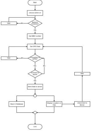
As shown in Figure 1 the proposed system consists of GPS receiver that every tracked pilgrim should have all the time. The GPS device receives the current location from GPS satellite and sends it periodically to the data base server through GPRS link of one of the cell phone service providers. The web server is connected to the data base server for updating the location of pilgrims on the maps impeded in the web application. The group guide monitors the pilgrims groups using portable device connected to the Internet.
Figure 1: Proposed system components
In the next following figure the data flow of the system model is shown to describe data movement between various objects.
442 A. Amro and Q. Abdel-Muti Nijem
2. Tracking Device
In order to have this suggested system flexible and cost efficient it was designed in a way such that any personal GPS tracking device could be used to track pilgrim’s movement. Moreover, mobile phones with embedded GPS receiver can also serve as a tracker for the same objective. The minimum requirements for the tracking device are: 1. the device should be able to receive GPS signal. 2. To be able to transmit the GPS location to the web server through cell phone network using GPRS service. 3. To have autonomous power supply. Devices with the following additional features are preferred. 1. To be water proof 2. The device has the ability to memorize three locations in which the pilgrim has been there recently. 3. The device has the Save Our Ship/Souls (SOS) functionality 4. The battery life of the device is longer than three days.
3. Database Specifications
Required and proper database for storing locations and other needed and gathered information, sent by the tracker, was built using MySQL RDBMS. The database is named as “ALMUTAWWIF”. It contains five related tables namely: Pilgrim, Group, Leader, Relative and Device. Each table has several needed attributes, proper primary key and other constrains needed to establish accurate relationships between tables and to maintain data integrity and retrieval efficiently. Figure 3 shows DB schema that describes the database of the system is organized and the relationships between various tables. In the schema, we have build a link between every pilgrim and his relative because of the situation when relatives lost each other is frequently faced and for situations when one of the relatives has a problem and the guide need the help of his relatives.
F 4 T grou web Man Figure 3: A 4. The Web The web-ba up guide. T b application nage and Lo ALMUTAW b-based app ased applica he applicati n consists o ogin/Logout WWIF databa plication ation was bu ion was dev of five interf t. Figure 4 s
ase schema
uilt for trac veloped usin faces which shows the H cking and m ng PHP with h are: Home Home page o monitoring p h free Goog e page, Regi of the applic pilgrims by gle API free
istration, Re cation.
their e. The eport,
444 A. Amro and Q. Abdel-Muti Nijem
The process of the system starts by the logging in process by the group’s guide who is enjoying administrator level privileges in the system. He group guide starts constructing the groups by performing join action for each pilgrim to the appropriate group in order to launch tracking process precisely.
All information that belongs to the pilgrim will be added and stored in the database using his Identification Device (IDD) value which is the same IDD of his tracking device hardware. After that the added pilgrims location appears on the Google map as a point by clicking on this point details about the location and the pilgrim appears.
One of the most important features of the web application is the geo-fencing which is "dynamically generated — as in a radius around a store or point location" according to (10). This feature allows the guide to set the radius that shouldn't be exceeded by any pilgrim. This feature is designed using the Haversine formulas (1).
)) sin( arcsin( 2 )) ( sin ( 1 R d harve R r d Rhaver d= − = (1)
According to the position of the pilgrim, the position of the guide (the center of the geo-fence), and the radius set by him, using formula 1 the web application defines if the pilgrim is out of the fence, and gives alert about every pilgrim going out the geo-fence. This feature helps the guide to predict pilgrim lost, while he/she can change the radius according to current situation, by making the radius small when the group is walking from one place to another and setting large radius in other situations. For better recognition of the individual pilgrim who went out the defined area the IDD information appears on the map with red position pin alerting the guide about the latest physical movements.
Immediate attendance check is also performed with the help of geo-fence feature. This feature saves time of the group by checking if all the pilgrims exist at the current moment; this feature is useful when the group have to move from one place to another. Another feature of the system is its capability to receive SOS signal from the pilgrim who need help or feels that he got lost.
5. Mobile Application
As we have mentioned before, the system was designed to deal with a mobile phone as a tracker. In this situation the mobile phone will receive the GPS data from the satellite and sends it using GPRS packet to the web server through GSM network.
6. Future work
This system is supposed to have real test in the coming Hajj of October 2012. One of the problems that could appear is the tracking signal may get lost or weakened inside the buildings. Many solutions exist to this problem and they should be worked out to avoid its impact on the test.
Another aspect of future work is to gather all Hajj groups in one unified system. This system will be very useful in solving problems of crowd management.
Also we suggest that combination of our GPS tracking system with RFDI systems such that proposed in (9) which could be very useful for solving different Hajj management problems.
7. Conclusion
Cost effective and flexible tracking system was developed, while the proposed system doesn't need building special infrastructure with maximum usage of already existing devices and technologies.
The proposed system satisfies the special needs of Hajj management and supposed to solve one of the most money effort consuming problems for the Hajj organizers.
References
1. CDSI. HAJJ STATISTICS - POPULATION AND VITAL STATISTICS - STATISTICS AND INFORMATION TABLES. CENTRAL DEPARTMENT OF STATISTICS AND INFORMATION. [ONLINE] 2011. [CITED: 31 JULY 2012.] HTTP://WWW.CDSI.GOV.SA/GEOSTAT/HAJSTAT.
2. An Internet-Based Interactive Embedded Data-Acquisition System for Real-Time Applications. Alkar, A.Z. and Karaca, M.A.,. no3, pp. 522-529, s.l. : IEEE Transactions on Instrumentation and Measurement, 2009, Vol. 58.
3. Design and Implementation of Intelligent Vehicle Monitoring and Management System Based on the Multi-Net. K.Xu, Y.Wang, W. Teng, Y. LIU. s.l. : Conference on Services Computing , 2006. APSCC '06. IEEE Asia-Pacific.
446 A. Amro and Q. Abdel-Muti Nijem
4. Ubiquitous GPS vehicle tracking and management system. Almomani, I.M., et al. Jordan : Conference on Applied Electrical Engineering and Computing Technologies (AEECT), IEEE, 2011.
5. Mobile Guardian: A novel positioning and monitoring system for outdoor special users based on GPS. Wu, Q., et al. s.l. : International Symposium on IT in Medicine and Education, pp. 596 - 600, 2008.
6. A secure tracking system for GPS-enabled mobile phones . BILGIC, H.T. and ALKAR, A.Z. s.l. : International Conference on Information Technology and Multimedia (ICIM) , 2011.
7. The Architecture and the Design of a Pilgrim Tracking System. Touir, A., Al-Owaisheg, A. and Mathkour, H. s.l. : 3rd International Information and Communication Technologies: From Conference on Theory to Applications (ICTTA 2008), 2008.
8. An Integrated System for Tracking and Control Pilgrims Shuttle Buses. Abdessemed, F. s.l. : 14th International IEEE Conference on Intelligent Transportation Systems (ITSC), 2011. pp.384 - 389.
9. Using RFID tags to Improve Pilgrimage Management. Hamad Binsalleeh, Noman Mohammed, Parminder S. Sandhu,, Feras Aljumah, and Benjamin C. M. Fung. al ain, UAE : Innovations in Information Technology, 2009. IIT '09. International Conference, 2009.
10. De Lara, Eyal, LaMarca, Anthony and Satyanarayanan, Mahadev. Location Systems: An Introduction to the Technology Behind Location Awareness. s.l. : Morgan & Claypool Publishers, 2008. ISBN 978-1-59829-581-8.