Annales Geophysicae (2003) 21: 221–236 cEuropean Geosciences Union 2003
Annales
Geophysicae
High resolution nested model for the Cyprus, NE Levantine Basin,
eastern Mediterranean Sea: implementation and climatological runs
G. Zodiatis1, R. Lardner1, A. Lascaratos2, G. Georgiou3, G. Korres2, and M. Syrimis3
1Oceanography Section, Department of Fisheries and Marine Research, Nicosia, Cyprus 2Oceanography group, Department of Meteorology, University of Athens, Athens, Greece 3Department of Mathematics and Statistics, University of Cyprus, Nicosia, Cyprus
Received: 28 May 2001 – Revised: 14 June 2002 – Accepted: 17 June 2002
Abstract. A high resolution nested flow model for the coastal, shelf and open sea areas of the Cyprus Basin, NE Levantine, eastern Mediterranean Sea is implemented to ful-fil the objectives of the Mediterranean Forecasting System Pilot Project, funded by the EU. The Cyprus coastal ocean model is nested entirely within a coarse regional grid model of the eastern Mediterranean Sea, using the MODB climatol-ogy for initialisation and the ECMWF perpetual year surface forcing. The nested simulations of the Cyprus model were able to reproduce, with greater detail, flow features similar to those of the coarse grid regional model. The project results show the feasibility of the approach for the development of an operational forecasting system in the Mediterranean Sea, particularly in the Cyprus coastal/shelf sea area.
Key words. Oceanography: general (descriptive and re-gional oceanography; numerical modelling) Oceanography: physical (general circulation)
1 Introduction
Knowledge of sea water movements is of importance in fore-casting the effects of human activities on the marine environ-ment. Today, flow modelling is considered a necessary oper-ational tool, useful to aid decision-making in case of events affecting marine operations or the marine environment. In this regard, the European Global Ocean Observing System (EuroGOOS, 1997) has promoted the Mediterranean Fore-casting System (MFS), in order to implement the operational oceanography in the region. The first phase in the realization of this goal is the development of the Mediterranean Fore-casting System Pilot Project (MFSPP) funded by the EU, in order to demonstrate that a Near Real Time (NRT) ocean forecast in the Mediterranean Sea is possible.
The scientific rationale of the MFS pilot project is based on the hypothesis that both hydrodynamical and ecosystem fluctuations in the coastal/shelf areas of the Mediterranean Correspondence to: G. Zodiatis ([email protected])
are intimately connected to the open sea large-scale general circulation. The project includes the implementation of ad-vanced modelling and data assimilation tools for NRT pre-diction. The oceanographic prediction models of the first phase are (Fig. 1):
– An Ocean General Circulation Model (OGCM) with 1/8×1/8 degree resolution over the whole Mediter-ranean Sea.
– Several Intermediate/Regional Models nested within the OGCM. The intermediate models have a 5–6 km reso-lution.
– One or more coastal/shelf models nested within each re-gional model. The shelf models have a 2–3 km resolu-tion.
The Cyprus Coastal Ocean Model (CYCOM) is one of the coastal/shelf models of the MFS pilot project, for high res-olution flow simulations in the Cyprus and the NE Levan-tine basins. It is nested within the Aegean LevanLevan-tine Eddy Resolving Model (ALERMO), which covers the whole east-ern portion of the Mediterranean Sea. In this paper, we present results for the seasonal variability of the circulation in the Cyprus Basin based on the ECMWF perpetual year sur-face forcing. Both CYCOM and ALERMO use numerical schemes that are modified versions of POM (the Princeton Ocean Model). The POM model has been widely used both within the framework of the MFSPP and elsewhere, to simu-late the flows in both regional and coastal/shelf sea areas of the Mediterranean Sea.
Fig. 1. High resolution simulations in the Mediterranean Sea with nested model and implementations: regional and shelf models of the
MFSPP project.
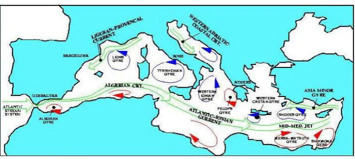
Fig. 2. Schematic of the main features of the general circulation in the Mediterranean, after Roussenov et al. (1995).
2 Known features of the general circulation
Progress in the definition of the circulation in the eastern Mediterranean Sea has come both from observational cam-paigns and numerical modelling (Fig. 2). The general flow picture in the Levantine Basin, derived from the observa-tional experiments (Brenner, 1989; Ozsoy et al., 1989; Ozsoy et al., 1991; POEM group, 1992), was shown to be dom-inated by the cyclonic activity of the Rhodes gyre in the northwestern part of the region, the Mersa Matruch and Shik-mona anticyclonic gyres in the southern part of the basin, the mid-Mediterranean jet (MMJ) and the Asia Minor current (AMC) in the Cilician Basin. Generally, the MMJ mean-ders eastward between these three gyres. To the southwest of Cyprus this current bifurcates, with a northward flow-ing branch along the western coast of Cyprus. The east-ward flowing branch of the MMJ, after passing south of Cyprus, bifurcates generally to the north, where after
pass-ing through the Lattakia Basin, enters the Cilician Basin and then flows to the west between a sequence of smaller scale cyclonic and anticyclonic eddies. The latter flow initiates the Asia Minor Current, which transfers warm and salty water (39.2–39.4 PSU) to the west (Ozsoy et al., 1989), and par-tially enters into the Aegean Sea through the eastern Cretan arc straits.
[image:2.595.114.480.320.484.2]G. Zodiatis et al.: High resolution nested model for the Cyprus, NE Levantine Basin 223
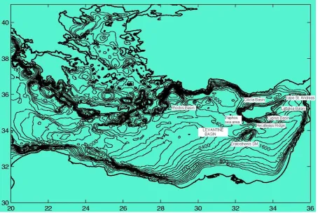
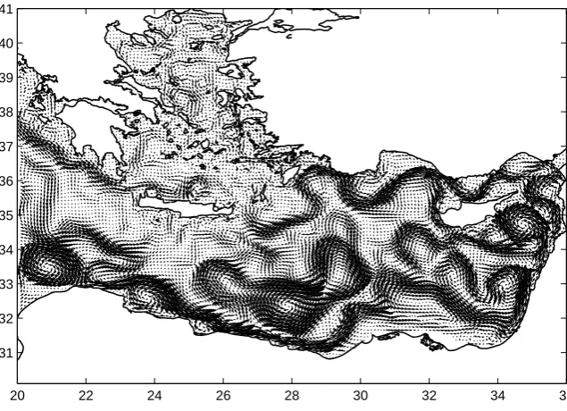
Fig. 3. Physiography and bathymetry of the eastern Mediterranean Sea. In the Levantine Basin some geographical names relevant to the
nested CYCOM model for the Cyprus and NE Levantine basins are also shown.
CYBO database reveals a warm westward coastal flow that periodically intrudes the Cyprus Basin along the northern pe-riphery of the Cyprus Basin Cyclonic Eddy from the western Lattakia Basin. The dominant flow phenomenon in the south-ern Cyprus Basin is the large-scale anticyclonic eddy that is attributed to the Cyprus anticyclonic eddy. This eddy was considered by the POEM group (1992) as the northernmost extension of the large Shikmona gyre. The significant sea-sonal and interannual fluctuation of the Cyprus anticyclonic eddy affects the spatial extent of the Cyprus Basin Cyclonic Eddy, the eastward meandering flow of the MMJ and the in-trusion of the warm Cyprus coastal current.
It is well-known that the general circulation in the Mediter-ranean Sea is induced both by wind stress at the sea surface and water density differences. The latter are established by such processes as heat fluxes, evaporation, precipitation and exchange with connected water bodies. The use of monthly and seasonal surface fluxes for several years in a coarse grid flow model of the Mediterranean Sea (Roussenov et al., 1995; Pinardi et al., 1997; Drakopoulos and Lascaratos, 1999) has shown a significant seasonal and interannual varia-tion of the circulavaria-tion at the upper layer, caused primarily by variations in the wind stress. The coastal/shelf areas of the Mediterranean are mostly dominated by the mesoscale flow phenomena of the neighbouring deep regions as they adjust to the physiographic characteristics of each coastal sea area.
The latter is especially true in the case of the Cyprus sea area, which has very narrow coastal areas, steep topographic gra-dients of the shelf breaks and an open shoreline (Fig. 3).
3 Description of the model
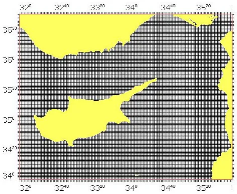
Poten-Fig. 4. CYCOM-Cyprus coastal ocean model domain with a
hori-zontal resolution of 3×3 km and 30 vertical layers from the surface
down to 2500 m.
tial temperature, salinity, velocity and surface elevation, are the prognostic variables of the model.
3.1 Model domain and initial data
The term Cyprus Basin, or NE Levantine Basin, is used gen-erally to indicate the northeastern end of the Mediterranean Sea and for the sake of precision, we have taken it as that part that is east of the 32◦E meridian and north of the 34◦N par-allel. Figure 3 shows the general physiography, as well as the bathymetry of this region. The Cyprus model domain is cov-ered by a uniform horizontal orthogonal grid with 3 km spac-ing in both the east-west and north-south directions (Fig. 4). The bottom topography is based on the 10 ×10 high
reso-lution NOAA (National Oceanic and Atmospheric Admin-istration) charts. After being objectively analyzed onto the Cyprus model grid, the depth values vary from surface down to 2500 m.
The requirement for the high resolution CYCOM model is that it should be capable of resolving scales associated with mesoscale phenomena, such as fronts and eddies. Their temporal scales are usually of the order of weeks to months, while their length scales are of the order of the local internal Rossby radius of deformation, which for the Levantine Basin is of the order of about 10–15 km (POEM group, 1992). It was considered that the chosen model grid size of 3 km is sufficiently shorter than this local radius of deformation to meet the requirement. It is also sufficient to resolve the steep bathymetry of the sea area west of Cyprus, in addition to defining quite well the rest of the model domain (such as the Cyprus, Lattakia and Cilicia Basins and the Hecateaus Ridge and the shelf areas around Cyprus).
The CYCOM model domain is approximately 440×300 km in extent, enclosing the island of Cyprus and consists of 146×122 horizontal grid points with two
open boundaries, to the west and to the south (Fig. 4). In the vertical, a non-uniform grid of 30σ layers was used with exponentially decreasing spacing near the surface and sea bed to provide finer resolution of the surface and bed layers. The precise geographical limits of the model domain are: Longitude: 32◦000–36◦000, Latitude: 34◦000–36◦450.
The CYCOM model was initialized on 1 January with the temperature and salinity data from the second year of a two-year run of ALERMO data, after these data were objectively analyzed to suit the Cyprus domain. To derive the initial data on 1 January, data for 30 December and 10 January were ex-tracted, objectively analyzed and interpolated. In addition, the monthly mean surface temperature and salinity climatol-ogy (T* and S*) from the second year of the ALERMO run was objectively analyzed and used for the surface relaxation of the heat and salt fluxes, as described below.
The ALERMO model covers the eastern Mediterranean Basin with one open boundary located at 20◦E (Korres and
Lascaratos, 2001a). The computational grid has a horizontal resolution of 1/20◦×1/20◦and a vertical discretisation using the same 30σlayers as CYCOM.
Both the surface forcing and the lateral boundary condi-tions are re-calculated interactively at each internal time step. The monthly ECMWF perpetual year atmospheric forcing used is based on the re-analyzed data with a spatial res-olution of 1◦×1◦ for the period January 1979–December 1993, while the back radiation for the CYCOM model was pre-computed by the ALERMO. In general, the monthly wind stress, solar radiation, evaporation and precipitation data were estimated to suit both the regional model and all the coastal/shelf models in the eastern Mediterranean, including the CYCOM model. The Budyko (1963) scheme and the Bignami (1995) formula for heat fluxes, the Jaeger (1976) precipitation and the polynomial approximation, given by Hellerman and Rosenstein (1983), for calculating the wind drag coefficient as a function of wind speed and the differ-ences between air-sea temperature were used for the pre-computation of the surface forcing parameters (Korres and Lascaratos, 2001b).
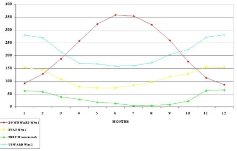
Monthly variations in the heat flux components at the two locations within the Cyprus model domain, NE Levantine Basin (SW and NE areas) shown in Fig. 5. The monthly cycle of the surface forcing parameters showed a maximum down-ward heat flux during June-July, while during early winter a maximum heat loss occurs. The maximum monthly total heat flux through the sea surface is found to exceed 200 W/m2 with a minimum value of about –200 W/m2.
3.2 Main characteristics of the numerical model 1. Nonlinear equations of momentum.
2. Sigma coordinate system in the vertical.
[image:4.595.46.282.62.255.2]G. Zodiatis et al.: High resolution nested model for the Cyprus, NE Levantine Basin 225
Fig. 5a. ECMWF surface forcing in the NE CYCOM model
domain: annual cycle of downward and upward heat fluxes, precipitation and evaporation.
Fig. 5b. ECMWF surface forcing in the SW CYCOM model
domain: annual cycle of downward and upward heat fluxes, precipitation and evaporation.
thus, lateral boundary conditions at points where grid level surfaces meet the sea bottom are avoided. Its dis-advantage is that an additional term, i.e. the gradient of bottom topography, is introduced into the pressure gradient. Prior to the finite-difference approximation of this term, the bathymetry is smoothed, in order to min-imize any truncation error that may be caused by steep topography. Sufficient smoothing is used to eliminate small-scale oscillations in the computed solution while maintaining the essential features of the bathymetry. 3. Time-splitting
The numerical algorithm is based on a splitting method: at each time step, the surface elevation and vertically integrated mass transports (that is, the barotropic mode) are computed from the depth-averaged equations by an explicit leapfrog scheme. Then the vertical structure of the current (baroclinic mode) is obtained from the hor-izontal momentum equations with a longer time step (Lardner and Cekirge, 1988). The main advantage of such a splitting algorithm is that the time step for ad-vancing the baroclinic mode can be large, since an im-plicit scheme is used for the vertical part of this mode and this scheme is, in theory, unconditionally stable. The time step,τ, for the barotropic mode is restricted by the CFL stability condition, which is approximately
τ < δ/√2gHmax, whereδis the grid spacing andHmax
is the maximum depth. However, a fast explicit algo-rithm is used for this part. Advancing the baroclinic mode is computationally much more demanding and the use of a longer time step for it makes the overall compu-tational scheme quite efficient. In the present CYCOM model domain, the time step for the external mode is 5 s, limited by the 3 km grid size and the maximum wa-ter depth of 2500 m, while the time step for the inwa-ternal mode is 450 s.
4. Horizontal Cartesian coordinates in the Mercator pro-jection with C-grid (Arakawa and Lamb, 1974). 5. All sub-grid-scale phenomena are considered as mixing
processes by introducing separate horizontal and verti-cal mixing terms:
(a) The horizontal mixing is modelled by an eddy viscosity defined by the scheme of Smagorinsky (1963), in terms of the grid size and the horizon-tal gradient of the velocity field,
AM =C1x1y
·
s
∂u
∂x
2
+
∂ν
∂y
2
+1 2
∂u
∂y +
∂ν ∂x
2
(1)
with coefficientC=0.2.
(b) The vertical eddy viscosity, a measure of the rate of momentum diffusion through the vertical, is treated by a second order-turbulence closure sub-model (Mellor and Yamada (1982)).
6. Fully prognostic mode.
[image:5.595.53.289.65.216.2]3.3 Equations of the model
Baroclinic mode continuity and horizontal momentum equations:
∂Du ∂x + ∂Dν ∂y + ∂ω ∂σ + ∂η
∂t =0 (2)
∂uD
∂t +
∂u2D
∂x +
∂uνD
∂y +
∂uω
∂σ −f νD+gD
∂η
∂x = −
gD2 ρ0 0 Z σ ∂ρ0 ∂x − ρ0 D ∂D ∂x ∂ρ0 ∂σ0
dσ0+ ∂
∂σ K M D ∂u ∂σ (3) ∂νD ∂t + ∂uνD ∂x +
∂ν2D
∂y +
∂νω
∂σ +f uD+gD
∂η
∂y = −
gD2 ρ0 0 Z σ ∂ρ0 ∂y − ρ0 D ∂D ∂y ∂ρ0 ∂σ0
dσ0+ ∂
∂σ KM D ∂ν ∂σ (4)
Conservation equations for temperature and salinity:
∂T D ∂t + ∂T uD ∂x + ∂T νD ∂y + ∂T ω ∂σ = ∂ ∂σ K H D ∂T ∂σ
+FT (5)
∂SD ∂t + ∂SuD ∂x + ∂SνD ∂y + ∂Sω ∂σ = ∂ ∂σ K H D ∂S ∂σ
+FS (6)
Barotropic mode depth-integrated continuity and momentum equations:
∂DU
∂x +
∂DV
∂y +
∂η
∂t =0 (7)
∂U D
∂t +
∂U2D
∂x +
∂U V D
∂y − ˜Fx+f V D+gD
∂η
∂x =
τx(s)
ρ +
τx(b)
ρ +Gx−
gD ρ0 0 Z −1 0 Z σ D∂ρ 0
∂x −σ
0∂D∂ρ0
∂x∂σ0
dσ0dσ (8)
∂V D
∂t +
∂U V D
∂x +
∂V2D
∂y − ˜Fy+f U D+gD
∂η
∂y =
τy(s)
ρ +
τy(b)
ρ +Gy−
gD ρ0 0 Z −1 0 Z σ D∂ρ 0
∂y −σ
0∂D∂ρ 0
∂y∂σ0
dσ0dσ (9)
3.4 Surface and bottom boundary conditions
1. The momentum, heat and salinity budget at the sea surface boundary are taken atσ =0 in the forms:
KM D ∂u ∂σ σ=0 = τ (s) x ρ , KM D ∂ν ∂σ σ=0 =τ (s) y
ρ . (10)
KH D ∂T ∂σ σ=0
= QT
ρCp
+ C1
ρCp
(T∗−T ) (11)
KH D ∂S ∂σ σ=0
=Ws+C2(S∗−S) . (12)
The solar radiation, salt flux Ws (from evaporation minus precipitation), as well as the momentum fluxes τx(s) and
τy(s) (wind stress), are computed using monthly climatol-ogy ECMWF perpetual year forcing (see Fig. 5 for exam-ples of solar radiation). The monthly evaporation rate E
was calculated from the ECMWF 1979–1993 6-hourly atmo-spheric data set and Reynolds monthly SST data (Reynolds and Smith, 1994), using the Kondo (1975) bulk formula.
The precipitation rateP is obtained from the Jaeger (1976) monthly precipitation climatology.
QT, the total heat flux, is equal to upward heat loss mi-nus solar radiation. The upward radiation imposed on the CYCOM model is the 10-day average upward heat flux diag-nosed from the second year of the ALERMO run, while the upward heat flux imposed on the ALERMO model is from the eighth year of the OGCM climatological run.
Weak relaxation termsC1(T∗−T ) andC2(S∗ −S) are
included in Eqs. (11) and (12) which act as further adjust-ments of the OGCM heat and salt fluxes to the ALERMO modelling area and, respectively, of the ALERMO fluxes to the CYCOM modelling area. In these terms, for CYCOM,
T∗andS∗are the monthly average sea surface temperature and salinity from the second year of the ALERMO run, while for ALERMO they are taken from the eighth year of the OGCM perpetual year run. Thus, these terms help to main-tain consistency among the three nested models. After sen-sitivity studies,C2has been set equal to 0.7 m/day. In both
ALERMO and CYCOM,C1is set equal to 5 W/(m2◦C).
G. Zodiatis et al.: High resolution nested model for the Cyprus, NE Levantine Basin 227
20 22 24 26 28 30 32 34 36
[image:7.595.49.367.63.293.2]31 32 33 34 35 36 37 38 39 40 41
Fig. 6. ALERMO circulation at 30 m,
for August of the second year of the cli-matological run.
errors, especially near their extreme values, while use of con-stant values forT∗ andS∗ for each month produces unac-ceptable oscillations in the computed fields after the end of each month. Therefore, we have followed the technique of Killworth (1996) to compute interpolants for the middle of each month, in such a way that linear interpolation ofT∗and
S∗between successive interpolants yields the monthly aver-ages in theT∗andS∗database.
2. Sea bed momentum condition is applied atσ = −1:
KM
D ∂u ∂σ
σ=−1
= τ (b) x
ρ ,
KM
D ∂ν ∂σ
σ=−1
= τ (b) y
ρ , (13)
where the bottom friction is parameterized using the quadratic friction law,
(τx(s), τy(s))= −Cρpu2+ν2(u, ν)|σ=0. (14)
The dimensionless drag coefficientC(x, y)is computed us-ing the empirical relationC(x, y) = [(1/κ)log(H /z0)]−2,
where κ is the Von Karman constant and z0 is the bottom
roughness.
3.5 Lateral boundary conditions and nesting
Along the closed coastal boundaries, the depth-averaged nor-mal velocity component is set to zero,Un=0. Open bound-aries create substantial computational difficulties in the mod-elling of a limited domain. In the present climatological sim-ulation, we have a high resolution model domain with open boundaries, embedded in a coarse resolution model. The circulation in the coastal/shelf areas encompasses flow fea-tures of various spatial scales, particularly in open sea areas, such as the Cyprus shelf, which are influenced greatly by the mesoscale flow phenomena of the neighbouring open sea waters, in this case, the SE Levantine Basin. Therefore, it
is very important that the nesting technique should allow the mesoscale features generated on the coarse model to influ-ence the embedded high resolution model domain, simulat-ing appropriate smaller scale flow features.
3.5.1 Nesting CYCOM with the ALERMO model
The Cyprus nested model has a 3-km grid spacing, with two open boundaries along the west and south sides (Fig. 4). The model is nested within the ALERMO model, which cov-ers the whole eastern half of the Mediterranean Sea, with a coarser grid (about 6 km), i.e. the nesting ratio is approxi-mately 2:1. The nesting method that has been used is a pas-sive, one way interaction (Spall and Holland, 1991), where the nesting provides for information to be passed along the open boundaries from the ALERMO coarse grid to the CYCOM high-resolution grid model. The successful nesting of the CYCOM model requires that the main flow features in the coarse grid must also be present in the high resolu-tion grid.
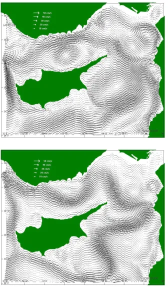
Fig. 7a. CYCOM circulation at 30 m,
[image:8.595.44.382.55.624.2]for February of the second year of the climatological run.
Fig. 7b. CYCOM circulation at 30 m,
for April of the second year of the cli-matological run.
10 January is reached. Then, the files for 10 January and 20 January are read and are interpolated for the next 10 days, and so on.
The process of interpolating the coarse grid variables to obtain the open boundary conditions for the high resolution grid model does not conserve the fluxes of mass, heat, or
G. Zodiatis et al.: High resolution nested model for the Cyprus, NE Levantine Basin 229
Fig. 7c. CYCOM circulation at 30 m,
[image:9.595.45.382.53.628.2]for June of the second year of the cli-matological run.
Fig. 7d. CYCOM circulation at 30 m,
for August of the second year of the cli-matological run.
is a small net volume flux into or out of the region, caused by round-off errors due to the interpolation from the coarse to the fine grid. Due to the small lateral extent of the region and the great water depths, this small imbalance produces very significant changes in surface elevation. To overcome this problem, the boundary values of velocities (barotropic and
baroclinic) from ALERMO are corrected immediately after they are read, so that the total volume flux into the Cyprus domain through each of its open boundary segments is pre-served (see the Appendix). The correction required is very small, generally less than 1 mm/s.
Fig. 7e. CYCOM circulation at 30 m,
for October of the second year of the climatological run.
model is nested within the intermediate/regional ALERMO model, as follows:
A. The surface elevation is not nested. A zero-gradient boundary condition is imposed for cosmetic purposes but does not affect the computation.
B. For the normal component of the barotropic (depth-averaged) velocity, a mixed radiation/specification con-dition is applied in the form (Flather, 1988):
UnCYCOM=UmALERMO
+ r
g
H η
CYCOM−ηALERMO
, (15)
where = 1 for an eastern or northern boundary and
= −1 for a western or southern boundary. This con-dition efficiently allows interior disturbances due to the mismatch between coarse and nested values to pass out through the lateral boundary.
C. The tangential component of the barotropic velocity is exactly specified by the interpolation of the coarse res-olution model field to the finer model grid:
Ut angCYCOM=Ut angALERMO. (16) D. Both normal and tangential components of the baro-clinic velocity are specified by the interpolation of the coarse resolution model field to the finer model grid
uCYCOMn =uALERMOn , uCYCOMt ang =uALERMOt ang . (17)
E. Advection onT andSinto the region:
When un is directed inwards to the fine grid region,
(un >0), T andS at the boundary of the fine grid are specified by the coarse model solution:
TCYCOM=TALERMO, (un>0)
SCYCOM=SALERMO, (un>0) . (18)
Whenunis directed outwards, the boundary values are determined by simple advection from the interior:
∂T
∂t +un
∂T
∂n =0, (un<0)
∂S
∂t +un
∂S
∂n =0, (un<0) . (19)
4 Results and discussion
In general, the CYCOM and ALERMO subsurface circula-tion patterns (Figs. 6 and 7) demonstrate that both models successfully reproduce the well-known characteristics of the circulation in the study area, namely the Mid-Mediterranean Jet, Asia Minor Current and Lattakia cyclonic eddy. On top of this, the CYCOM model circulation patterns appear to be enriched in mesoscale structures, which are either missing or not well resolved by the coarse-intermediate resolution ALERMO model.
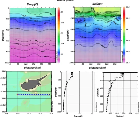
G. Zodiatis et al.: High resolution nested model for the Cyprus, NE Levantine Basin 231 15 17.5 20 22.5 25 14 14.5 15 15.5 16 16.5 17 13.7 13.8 13.9 O c e a n D a ta V ie w
0 50 100 150 200 250
1000 800 600 400 200 0 Temp(C) Distance [km] D e p th (m ) 38.7 38.8 38.9 39 39.1 39.2 38 .76 38.78 38.7 8 38.8 3 8
.8 38.82
38 .82 3 8.8 2 38 .84
38.86 38.9 38.88
38.92 38.94 38.96 3 8 .9 6 38.98 38 .9 8 O c e a n D a ta V ie w
0 50 100 150 200 250
1000 800 600 400 200 0 Sal(ppt) Distance [km] D e p th (m ) O c e a n D a ta V ie w
15 20 25
1000 800 600 400 200 0 Temp(C) D e p th (m ) O c e a n D a ta V ie w
38.8 38.9 39.0 39.1 39.2 1000 800 600 400 200 0 Sal(ppt) D e p th (m )
31˚E 32˚E 33˚E 34˚E 35˚E
33˚N 33.5˚N 34˚N 34.5˚N 35˚N 35.5˚N 36˚N O c e a n D a ta V ie w Winter period
[image:11.595.72.526.67.447.2]ODV5.5: C:\VOS\POM10201; C:\VOS\pom10201.cfg; C:\VOS\.sec - Jun/18/2002 08:46:28
Fig. 8a. CYCOM temperature and salinity vertical structure and their composite profiles along the east-west section south of Cyprus, winter
period of the second year of the climatological run.
and coastal flow features in more detail than previous com-putations. The results show several known features of the basin’s general climatological circulation comprising several eddies and flow jets (Fig. 7).
The dominant flow features of the CYCOM domain were the strong MMJ, which is shown clearly to bifurcate SW of Cyprus, and the Lattakia cyclonic eddy. Both features appear almost throughout the entire period of the model simulations, except in the spring and autumn periods, where a significant spatial fluctuation was found. The main eastward branch of the MMJ is meandering south of Cyprus, then after passing Cyprus, the MMJ turns to the north, entering into the Lattakia Basin. The existence of the well developed Lattakia cyclonic eddy forces the MMJ to flow northward, initially closer to the coast of Lebanon, while further closer to the most north-eastern edge of Cyprus, the Saint Andreas Cape, from where the MMJ enters the Cilician Basin. The secondary anticy-clonic eddy which appears in the Lattakia Basin, close to the Lebanese coast, re-circulates part of the waters entering with
the MMJ, through the southeastern boundary of the model domain. The description of the CYCOM results about the MMJ and of the Lattakia cyclonic eddy are mostly in agree-ment with the previous observational investigation in the area (Ozsoy et al., 1991; Zodiatis et al., 1998b; Krivisheya et al., 1998). Along the western coastline of Cyprus, the deflected northward branch of the MMJ generally flows northward, to-wards a convergence with the Asia Minor Current. Moreover, a small-scale anticyclonic eddy was found to be generated off the coast of Paphos (western coastline of Cyprus) during spring, inducing a southward flow within a few kilometres of that coast.
15 17.5 20 22.5 25 14 14.5 15 15.5 16 16.5 17 17.5 18 18.5 19 13.7 13.7 13.8 13.9 O c e a n D a ta V ie w
0 50 100 150 200 250
1000 800 600 400 200 0 Temp(C) Distance [km] D e p th (m ) 38.7 38.8 38.9 39 39.1 39.2 38.74 38.74 38.76
38.7 6 38.78 38.78 38 .8 38.8
38.82 38.82
38.84 38.84 38.8
4 38.86
38.86
38.8838.9238.94 38.938.98 38.96
39 39
39.0239.0839.1239.0439.139.06 39.0239.0439.0639.08
O c e a n D a ta V ie w
0 50 100 150 200 250
1000 800 600 400 200 0 Sal(ppt) Distance [km] D e p th (m ) O c e a n D a ta V ie w
15 20 25
1000 800 600 400 200 0 Temp(C) D e p th (m ) O c e a n D a ta V ie w
38.8 38.9 39.0 39.1 39.2 1000 800 600 400 200 0 Sal(ppt) D e p th (m )
31˚E 32˚E 33˚E 34˚E 35˚E
33˚N 33.5˚N 34˚N 34.5˚N 35˚N 35.5˚N 36˚N O c e a n D a ta V ie w Summer period
[image:12.595.71.525.65.454.2]ODV5.5: C:\VOS\POM10203; C:\VOS\pom10203.cfg; C:\VOS\pom10203.sec - Jun/18/2002 08:48:31
Fig. 8b. CYCOM temperature and salinity structure and their composite profiles along the east-west section south of Cyprus, summer period
of the second year of the climatological run.
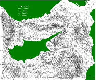
summer, between the AMC and the coastline of the Asia Mi-nor, an anticyclonic eddy was generated, while smaller scale weak anticyclonic activities existed both west and east of the main cyclonic eddy of the Cilician Basin. The anticyclonic eddy, circulating at the entrance between the Lattakia and Cilician basins, forces the waters transferred by the MMJ to enter the Cilician Basin closer to the most northeastern edge of Cyprus, the Cape Saint Andreas. Previous investigation in the area (Ozsoy et al., 1991) shows that this anticyclonic eddy was capable of blocking the northward propagation of the MMJ into the Cilician Basin during certain periods. On the contrary, the present nested high resolution simulations of the CYCOM model give clear evidence that this anticy-clonic eddy is not capable of blocking entirely the entry of the MMJ in the Cilician Basin and shows that the MMJ is continuously entering the Cilician Basin all year round.
It is of interest to mention that the main hydrographic fea-tures from the observational climatology were reproduced quite well by the CYCOM. The applied model was able to
G. Zodiatis et al.: High resolution nested model for the Cyprus, NE Levantine Basin 233
Fig. 9. Comparison of the circula-tion in the SE Levantine Basin at the 30 m depth, between: (a) the OGSM NRT operational forecasts and (b) the geostrophic flow (currents + dynamic height) derived from the CYBO project, both during the TOP period, May 2000.
between 1995–2001 within the frame of the CYBO, CY-CLOPS and MFSPP projects (Zodiatis et al., 1998a; Zodi-atis et al., 2001; Manzella et al., 2001). The surface saline waters and the LIW were found to occupy the eastern part of the model domain, while the western part of the model do-main is intruded by the MAW, which is transferred in the area by the MMJ. The salinity vertical profiles (Fig. 8) show that the MAW is well pronounced during the summer periods, while due to the winter mixing processes, these less saline surface and subsurface waters, having been mixed down to 100 m depth with the surrounding waters, are hardly evident
in the area.
nest-Fig. 10. Comparison of the circu-lation in the SE Levantine Basin at
the 30 m depth, between: (a) the
CYCOM NRT operational forecasts (currents + temperature at the 30 m) for 29 March 2002 and (b) the geostrophic flow (geostrophic currents + dynamic height) derived from the CYBO project during March 2002.
ing technique, allowing fine-scale features to be analyzed in regions where they may be important at relatively little extra computational cost.
Despite the improvements of the flow picture in the NE Levantine Basin, as a result of the application of the CYCOM model, it is still evident that the present simulations, based on the climatology of the ECMWF perpetual year surface forcing, were not able to resolve certain flow phenomena that were derived from the renewed investigations in the SE Levantine Basin, carried out by the CYBO project between 1995–2001. The overall picture of the circulation derived from the CYBO project reveals a detailed flow pattern in the
neighbourhood of the southern coast of Cyprus and flow fea-tures, such as the Cyprus Basin Cyclonic Eddy and the warm core of the Cyprus eddy, which undergo strong seasonal and interannual fluctuations (Zodiatis et al., 2001).
[image:14.595.45.379.62.559.2]G. Zodiatis et al.: High resolution nested model for the Cyprus, NE Levantine Basin 235 In view of the above, the comparison of the NRT
opera-tional forecasts, produced from the OGCM during the MF-SPP TOP period in spring 2000, with the geostrophic flow, estimated from in situ data collected in the frame of the CYBO project during the same period, in May 2000, show similar flow features in the SE Levantine Basin (Fig. 9). In particular, a good agreement was found for the large-scale warm core Cyprus eddy, in accord with the POEM group (1992), attributed to the northern eddy composite, the Shik-mona gyre, the meandering path of the MMJ and the enlarged north-south direction of cyclonic activity, all of which are lo-cated south of Cyprus.
Finally, it is worth mentioning that the recent develop-ments and the upgrade of the CYCOM model to opera-tional status, nested entirely within the ongoing operaopera-tional forecasts of the MFSPP OGCM model, made it possible to produce daily operational forecasts on a weekly basis, using actual near-time surface forcing. The results of the CYCOM NRT ocean forecasts in the Cyprus model domain for March 2002 were in agreement with the general circu-lation pattern of the SE Levantine Basin, estimated from in situ data collected during the same period in the frame of the CYBO project (Fig. 10).
5 Conclusions
The response of the Cyprus and NE Levantine Basins, east-ern Mediterranean Sea to MODB and ECMWF climatologi-cal forcing is studied using the Cyprus coastal ocean model (CYCOM), a shelf/coastal adaptation of the POM’s primitive equations, nested entirely within the regional Aegean Levan-tine eddy resolving model (ALERMO). The main known climatological features of the local circulation are found to be reproduced quite well by the CYCOM model, particularly that of the MMJ and its bifurcation SW of Cyprus, and the cyclonic eddies in the Lattakia and Cilician basins. In addi-tion, the model flow simulations show good agreement with those of the regional model that provides its lateral bound-ary data.
The modelling task reported here shows that develop-ment of an operational near real-time ocean forecasts in the coastal/shelf areas of the Mediterranean, which is the ul-timate goal of the Mediterranean Forecasting System, can be achieved through the implementation of high resolu-tion nested models, similar to that applied in the Cyprus shelf/coastal and open sea domain.
Appendix A
We require the following interpolation constraint for each section of the open boundary:
l2
Z
l1
0 Z
−hCOARSE
UnCOARSEdzdl= l2
Z
l1
0 Z
−hFINE
UnINTdzdl≡
Z Z
R
UnINTdzdl ,(A1)
whereUnCOARSEis the normal component of the coarse grid velocity field,UnINTis the normal component of the interpo-lated velocity vield,Rstands for the section of the boundary of the high resolution grid, andhCOARSE andhFINE are the bathymetries of the coarse and fine-resolution grids.
To satisfy the constraint given by Eq. (A1), three steps are necessary:
Step 1:. Calculate the original volume flux on the COARSE GRID:
l2
Z
l1
0 Z
−hCOARSE
UnCOARSEdzdl=V FCOARSE (m3/s) (A2)
Step 2:. Calculate the corresponding flux using INTERPOLATED velocities on the FINE GRID:
Z Z
R
UnINTdzdl=
l2
Z
l1
0 Z
−hFINE
UnINTdzdl=V FINT(m3/s) . (A3)
Step 3:. Calculate the mean velocity correction:
1U=
V FINT−V FCOARSE
S (m/s) , (A4)
whereSis the cross sectional area,
S= Z Z
R
dldz (m2) . (A5)
Then the interpolated normal velocity is corrected as follows:
UnCORR(x, y, z, t )=UnINT(x, y, z, t )1U·F (x, y, z) , (A6)
whereF can be any function whose average over the section is equal to 1:
Z Z
R
F (x, y, z) dldz=S. (A7)
F (x, y, z) = 1 is the simplest choice and gives a uniform
velocity correction over the whole section. An alternative choice isF (x, y, z)proportional toUnINT(x, y, z, t ), which leads to a corrected velocity everywhere proportional to the original interpolated velocity. The simplest way of writing this is
UnCORR(x, y, z, t )=UnINT(x, y, z, t ) V F
COARSE
V FINT
!
. (A8)
Acknowledgements. This research has been carried out in the framework of the European Union MFSPP-Mediterranean Forecast-ing System Pilot Project, a EuroGOOS activity. We acknowledge the support of the European Commission‘s Marine Science and Technology Programme (MAST IV), contract MAS3-CT98–0171.
References
Arakawa, A. and Lamb, V. R.: Computational design of the UCLA general circulation model, Methods in Computational Physics, v.17, Academic Press, 173–265, 1974.
Bignami, F., Marullo, S., Santoreli, R., and Schiano, M. E.: Long-wave radiation budget in the Mediterranean sea, J. Geophys. Res., 100, 2501–2514, 1995.
Blumberg, A. F. and Mellor, G. L.: A description of a
three-dimensional coastal ocean circulation model, in: Three-Dimensional Coastal Ocean Circulation Models, (Ed) Heaps, N. S., Coastal Estuarine Sci., vol. 4, AGU, Washington, D.C., 1–16, 1987.
Brenner, S.: Structure and evolution of warm core eddies in the eastern Mediterranean Levantine Basin, J. Geophys. Res., 94, 12 593–12 602, 1989.
Budyko, M. I.: Atlas of the heat balance of the Earth, Glabnaia Geofiz. Observ., 1963.
Drakopoulos, P. G. and Lascaratos, A.: Modelling the Mediter-ranean Sea: climatological forcing, J. Marine Systems, 20, 157– 173, 1999.
EuroGOOS: The strategy for EuroGOOS, EuroGOOS Pupl., 1, 132, 1997.
Flather, R. A.: A numerical model investigation of tides and diurnal period continental shelf waves along Vancouver, J. Phys. Ocean., 18, 115–139, 1988.
Hellerman, S. and Rosenstein, M.: Normal wind stress ocer the word ocean with error estimates, J. Phys. Ocean., 13, 1093–1104, 1983.
Jaeger, L.: Monatskarte des Niederschlags fur die ganze Erde, Be-richte des Deutschen Wetterdienstes, Band 18 (139), 1–38, 1976. Killworth, P. D.: Time interpolation of forcing fields in ocean
mod-els, J. Phys. Ocean., 26, 136–143, 1996.
Kondo, J.: Air-sea bulk transfer coefficients in diabatic conditions, Boundary-Layer Meteorol. 9, 91–112, 1975.
Korres, G. and Lascaratos, A.: The Aegean-Levantine eddy resolv-ing model (ALERMO): implementation and climatological runs, Rapp. Comm. int. Mer. Medit., 36, 70 p., 2001a.
Korres, G. and Lascaratos, A.: A climatological atmospheric forc-ing data set for use with general circulation models of the Mediterranean Sea, Rapp. Comm. int. Mer. Medit., 36, 71 p., 2001b.
Krivosheya, V. G., Titov, V. B., Ovchinnikov, I. M., Moskalenko, L. V., Yakubenko, V. G., Abousamra, F., Aboucora, I., and Boura, C.: The geostrophic circulation and currents structure in the east-ern Mediterranean between the Syrian coast and Cyprus island in winter and summer seasons, Rapp. Comm. Int. Mer Medit., 35, 158 p., 1998.
Lardner, R. W. and Cekirge, H. M.: A new algorithm for three-dimensional tidal and storm surge computations, App. Math.
Model. 12, 471–571, 1988.
Lascaratos, A. and Nittis, K.: A high resolution three-dimensional numerical study of intermediate water formation in the Levantine Sea, J. Geophys. Res., 103, 18 497–18 511, 1998.
Manzella, G. M. R., Cardin, V., Cruzado, A., Fusco, G., Gacic, M., Galli, C., Gasparini, G. P., Gervais, T., Kovacevic, V., Millot, C., Petit DeLa Villeon, L., Spaggiari, G., Tonani, M., Tziavos, C., Velasquez, Z., Walne, A., Zervakis, V., and Zodiatis, G.: EU-sposored effort improves monitoring of circulation variability in the Mediterranean, EOS, 82, 43, 497–504, 2001.
Mellor, G. and Yamada, T.: Development of a turbulent closure model for geophysical fluid problems, Rev. Geophys., 20, 851– 875, 1982.
Ozsoy, E., Hecht, A., and Unluata, U.: Circulation and hydrogra-phy of the Levantine Basin, Results of the POEM coordinated experiments 1985–1986, Progr. Oceanogr, 22, 125–170, 1989. Ozsoy, E., Hecht, A., Unluata, U., Brenner, S., Oguz, T., Bishop,
J., Latif, M. A., and Rozentraub, Z.: A review of the Levantine Basin circulation and its variability during 1985–1988, Dynam-ics Atm. Oceans, 15, 421–456, 1991.
Pinardi, N., Korres, G., Lascaratos, A., Roussenov, V., and Stanev, E.: Numerical simulation of the interannual variability of the Mediterranean Sea upper ocean circulation, Geophys. Res. Lett., 24, 4, 425–428, 1997.
POEM group: General circulation of the eastern Mediterranean Sea, Earth Sci. Rev., 32, 285–309, 1992.
Reynolds, R. W. and Smith, T. M.: Improved global sea surface temperature analyses, J. Climate, 7, 929–948, 1994.
Roussenov, V., Stanev, E., Artale, V., and Pinardi, N.: A seasonal model of the Mediterranean Sea general circulation, J. Geophys. Res., 100, 13 515–13 538, 1995.
Schlitzer, R.: Ocean Data View, http://www.awi-bremerhaven.de/ GEO/ODV, 2001.
Smagorinsky, J.: General circulation experiments with the primitive equations. Part I: the basic experiment, Monthly Weath. Rev., 91, 99–165, 1963.
Spall, M. A. and Holland, W. R.: A nested primitive equation model for oceanic applications, J. Phys. Oceanogr., 21, 205–220, 1991. Zavatarelli, M. and Mellor, G. L.: A numerical study of the Mediter-ranean sea circulation, J. Phys. Oceanogr., 25, 1384–1414, 1995. Zodiatis, G., Theodorou, A., and Demetropoulos, A.: Hydrography and circulation in the area south of Cyprus in late summer 1995 and in spring 1996, Oceanologica Acta, 21, 447–458, 1998a. Zodiatis, G., Demetropoulos, A., and Theodorou, A. J.: A review of
the circulation in the Cyprus Basin, eastern Mediterranean Lev-antine Basin, Rapp. Comm. int. Mer Medit., 35, 210 p., 1998b. Zodiatis, G., Manca, B., and Balopoulos, E.: Synoptic, seasonal and