P l e i s t o c e n e g l a c i a t i o n in Kurdistan
B y H . E . W R I G H T , J r . , Minneapolis
With 17 figures and 3 tables. Table of Contents Introduction
Physical and climatic setting Algurd Dagh area
Bola Valley Birkim Valley Beni Valley Sideke area Ruwandiz River area
Galala Valley Marana Valley Ruwandiz headwaters Marana-Galala-Razan segment Berserini Gorge Diyana Plain
Ruwandiz River and Khalan Valley Summary and conclusions Cilo Dagh area
Other areas in Taurus-Zagros Ranges Discussion
References cited
Z u s a m m e n f a s s u n g . Die Berge Kurdistans sind ein Teil des Taurus-Zagros-Gebirgs-zuges, der sich durch die südliche Türkei, den nördlichen Irak und den südwestlichen Iran hinzieht und das anatolisch-iranische Hochland vom mesopotamischen Tiefland trennt. Der Kamm erreicht Höhen von 3000-4000 m im Abschnitt des Cilo Dagh-Gebietes in der südöstlichen Türkei bis zum 250 km entfernten Gebiet des Algurd Dagh im nördlichen Iran. In südöstlicher Richtung senkt sich die Kammhöhe auf 2200 bis 2800 m, erreicht jedoch im Zardeh Kuh des südlichen Iran örtlich wieder Höhen von 4000 m. Die höchsten Erhebungen des Gebirges liegen gewöhnlich im Gürtel der metamorphen Gesteine. D i e äußeren Kämme bauen sich meist aus langen Faltenzügen meso zoischer Kalkgesteine auf; in den Vorbergen sind es Faltenzüge, die sich aus Sedimenten bis hinauf zum Pliozän zusammensetzen. Innerhalb Kurdistans werden die einzelnen Gebirgszüge von 4 Hauptzuflüssen des Tigris (Khabur, großer und kleiner Zab und Diyala) durchschnitten.
Das Klima Kurdistans ist durch winterliche Niederschläge und sommerliche Dürre gekenn zeichnet. Die Regenmengen werden teilweise von Zyklonen gebracht, die vom Mittelmeer herüber ziehen, teilweise aber auch durch Umströmung einer Antizylone, deren Zentrum im Winter über der arabischen Halbinsel liegt. Die regionalen Niederschläge nehmen mit der Höhe zu und be tragen von 300 mm pro J a h r in den äußeren Vorbergen bis über 1000 mm in den höchsten Teilen des Gebirges im Gebiet des Cilo Dagh und Algurd Dagh. Die Niederschlagsmenge erreicht hier nicht nur ein Maximum, weil die Berge hoch und massig sind, sondern auch deshalb, weil das Streichen der Ketten von E nach SE umschwenkt. Die Stürme, welche der äußeren Flanke in öst licher Richtung vom Mittelmeer her folgen, werden gezwungen, über das Gebirge zu steigen oder sie werden nach S E abgelenkt. Jenseits des Gebirges, auf den Hochflächen Anatoliens und des Irans, nimmt die Regenmenge auf 300 bis 500 mm ab.
Die Vegetation Kurdistans bezeichnet recht deutlich die verschiedenen Klimazonen. Die untere Baumgrenze liegt gewöhnlich zwischen 700 und 1000 m auf den äußeren Vorbergen der Ketten und begleitet in dieser Höhe fast das gesamte Gebirge. Sie folgt ungefähr der 500-mm-Nieder-schlagslinie. Das Waldland besteht vorwiegend aus Eichen; dieses ist örtlich infolge von Holz einschlag und Ziegenfraß allerdings nur noch Strauchwerk. In den höheren Teilen der Waldzone tritt gelegentlich Wacholder auf. Ahorn, Walnuß, Weißdorn, Mandel und Esche kommen zusam men mit Eiche in mittleren Höhenlagen vor. Pistazien und Olivenbäume finden sich an einigen trockeneren Stellen. Die obere Baumgrenze auf den äußeren Ketten zieht sich in einer Höhe von ungefähr 2000 m hin. Sie ist in dieser Höhe wahrscheinlich bedingt durch die Temperatur (Januar mittel ca. 10° C ) . In SE-Richtung, dem Gebirge entlang im Iran, wo die höchsten Erhebungen ge wöhnlich unter 3000 m liegen, reicht die Waldbedeckung weiter ins Landesinnere und hört an
132 H . E. Wright
einer „inneren Baumgrenze" auf, wo die jährliche Niederschlagsmenge ca. 500 mm und die Höhen lage etwa 1300-1500 m beträgt.
Glaziale Erscheinungen des Pleistozäns wurden hauptsächlich in 3 Regionen untersucht: im Gebiet des Algurd Dagh im Irak, dem nahe gelegenen Ruwandiz-Flußgebiet und dem Cilo-Dagh-Gebiet in der Türkei. Die Kämme in der Nähe des Algurd Dagh erreichen Höhen von 3000-3500 m. Sie liegen zum Entwässerungssystem so, daß sich ausgedehnte pleistozäne Gletscher an den Nord hängen bildeten, die ihre Zungen durch enge Schluchten südwärts in die Nebentäler des großen Zab bis auf Höhen von 1100m hinab vorschoben. Die oberen Teile von breiten Tälern wurden durch Glazialschutt verstopft. Ausgeprägte Moränengürtel haben sich nicht gebildet; Seen und andere kleine Eintiefungen sind vorhanden. Kleine Kare, deren Böden bis auf 1500 m heruntergehen, wurden auf den nach Norden zu abfallenden Hängen der Nebenketten festgestellt. Im Tal des Ruwandiz, eines der Hauptzuflüsse des großen Zab, liegen 40—60 m über dem heutigen Flußbett 30 m mächtige Terrassen, die aus fluvio-glazialen Kiesen des Pleistozäns aufgeschottert worden sind. Obwohl auf einigen vom Ruwandiz durchquerten Kämmen frische Kare entdeckt wurden, enden die Terrassen nicht in einem ausgeprägten Moränen-Komplex, und es ist daher möglich, daß sie älter sind als der letzte Hauptvorstoß des Eises. Die Beziehungen werden kompliziert durch Ab lagerungen, die Bergstürzen im Quellgebiet zugeschrieben werden. In die Terrassen selbst ist Schutt und Bodenmaterial eingeschaltet; sie werden von mächtigem Schutt überlagert, der in die letzte eiszeitliche Phase wie auch in das Postglazial gehören kann. Auf frühere pleistozäne Ereignisse in diesem Gebiet weisen noch höher gelegene Bänke einer Kalksteinbreccie an den Berghängen (mit Höhlen des Moustier), sowie der Überrest einer Ablagerung aus Sand und Kies und dünne Lagen eines limnischen Silts und Kalksteines in einer Höhe von 250 m über dem Ruwandiz. Im Norden des Cilo Dagh in der südöstlichen Türkei wurden glaziale Ablagerungen des Pleistozäns dem großen Zab entlang bis herunter auf 1500 m gefunden. Sie wurden durch Gletscher herangebracht, die ihren Ursprung auf der Nordseite des Cilo Dagh sowie auf nördlich und nordwestlich gelege nen Nebenketten hatten. Die tiefsten festgestellten Kare liegen in einer Höhe von ungefähr 1800 m, doch lagen die aufgesuchten Gebiete im nördlichen Teil des Vereisungsgebietes, wo die Nieder schlagsmenge geringer ist als im eigentlichen Gebiet des Cilo Dagh und seiner äußeren Flanke.
Obwohl heute keine Gletscher im Algurd Dagh-Gebiet vorhanden sind, wurden mehrere kleine Reste von BOBEK in Karen des Cilo Dagh verzeichnet. Die gegenwärtige Schneegrenze auf den Schattenseiten wird auf eine Höhe von ca. 3300 m gelegt. Pleistozäne Kare in 2100 m Höhe im Gebiet des Cilo Dagh und in 1500 m Höhe im Gebiet des Algurd Dagh fordern eine Erniedri gung der Schneegrenze im Pleistozän um 1200 bis 1800 m, eine Zahl, die wesentlich höher liegt
als die von BOBEK geforderten 700 m.
Wenn die pleistozäne Erniedrigung der Schneegrenze als alleinige Folge der Temperaturernie drigung angesehen wird, muß die mittlere Jahrestemperatur um mindestens 12° C tiefer gelegen haben (bezogen auf einen vertikalen Temperaturabfall von 0,7° C auf 100 m). Ein solcher Wert wäre genau so groß, wie der für Mitteleuropa angenommene, wo Permafrost, Tundren-Flora und -Fauna offensichtlich weit verbreitet waren. In Kurdistan gibt es keine Frosterscheinungen oder paläontologischen Belege, die derartig niedrige Temperaturen andeuten würden. So ist es wahr scheinlich, daß die Vereisung die Folge sowohl stärkerer Schneefälle als auch einer geringen Tem peraturabsenkung war. Dieser Schluß gilt nur für die äußere Flanke der Berge Kurdistans, die wesentlich größere winterliche Schneefälle in dem Maße erhalten haben können, wie die mediter ranen Stürme am Rande einer verstärkten asiatischen Antizyklone an Intensität gewannen. Auf den Hochflächen Anatoliens und des Irans muß die Niederschlagsmenge nicht unbedingt größer gewesen sein; die Suche nach verläßlichen geologischen und paläontologischen Beweisen muß in diesem Gebiet noch fortgesetzt werden.
Trotz des Nachweises unterschiedlicher klimatischer Bedingungen in Kurdistan während der letzten Vereisungsphase des Pleistozäns gibt es wenig Beweise dafür, daß der klimatische U m schwung gegen Ende des Pleistozäns für die Entwicklung des Menschen vom Jäger zum Acker bauer und Viehzüchter entscheidend war. Die Übergangsstadien liegen in dem Zeitraum von 11000 bis 9000 Jahren vor heute. Es ist wahrscheinlich, daß der Klimawechsel, der den Rückzug der Gletscher bewirkte, zu jener Zeit im wesentlichen abgeschlossen war. Auf jeden Fall kann der pleistozäne Klimawechsel nur eine höhenmäßige Verlagerung der Lebensbereiche innerhalb der Berge Kurdistans, der Vorberge und der mesopotamischen Rumpffläche zur Folge gehabt haben, so daß sogar während der Vereisungsperioden Gebiete vorhanden waren, die solchen Tieren und Pflanzen Lebensmöglichkeiten boten, die domestiziert werden konnten, sobald der Mensch das dafür notwendige Kulturniveau erreicht hatte.
A b s t r a c t . The mountains of Kurdistan are a portion of the Taurus-Zagros, mountain arc that extends through southern Turkey, northern Iraq, and southwestern Iran and separates the Anatolian-Iranian Plateaus from the Mesopotamian Lowland. The crest reaches elevations of 3000-4000 m in the segment from the Cilo Dagh area in southeastern Turkey for 250 km to the Algurd Dagh area in northern Iraq. Southeastward the crestal elevation descends to 2200-2800 m,
but in the Zardeh Kuh of southern Iran it again locally reaches 4 0 0 0 m. The highest part of the range is generally in the belt of metamorphic rocks. The outer ridges are formed mostly by long folds of Mesozoic limestone, giving way in the foothills to folds in sediments as young as Pliocene. Within Kurdistan the ranges are cut transversely by four major tributaries of the Tigris River, namely the Khabur, Greater Zab, Lesser Zab, and Diyala Rivers.
The climate of Kurdistan is marked by winter precipitation and summer drought. The rains are brought in part by cyclonic disturbances from the Mediterranean Sea, and in part by circu lation around an anticyclone centered in winter over the Arabian peninsula. The regional preci pitation increases with elevation in the mountains, and ranges from about 3 0 0 mm per year in the outer foothills to more than 1 0 0 0 mm in the highest part of the range in the area of the Cilo Dagh and Algurd Dagh. The precipitation reaches a maximum here not only because the moun tains are high and massive but also because here the trend of the ranges shifts from east to south east, and the storms which follow the outer flank of the range from the Mediterranean Sea east ward are forced to rise over the mountains or be diverted sharply to the southeast. Inland from the mountains on the high Anatolian and Iranian Plateaus the precipitation falls abruptly to
3 0 0 - 5 0 0 mm.
The vegetation in Kurdistan closely reflects the climate. The lower treeline has a general ele vation of 7 0 0 - 1 0 0 0 m on the outer foothills of the mountains for most of the distance along the ranges, and follows approximately the 5 0 0 mm precipitation line. The woodland consists domin-antly of deciduous oak, locally reduced to scrub by woodcutters and goats. In addition juniper may be found generally in the upper part of the forest zone. Maple, walnut, hawthorne, almond, and ash occur with the oak at middle elevations, and pistachio and olive are found on some of the drier sites. The upper treeline on the outer ranges occurs at an elevation of about 2 0 0 0 m, and is presumably limited at this elevation by the temperature (January mean about 1 0 ° C ) . South eastward along the range in Iran, where the crests of the ridges are generally less than 3 0 0 0 m, the forest cover extends farther inland and terminates in what may be considered an inner tree-line, where the precipitation is about 5 0 0 mm and the elevation about 1 3 0 0 - 1 5 0 0 m.
Pleistocene glacial features were studied principally in three regions, the Algurd Dagh area in Iraq. Ruwandiz River area nearby, and the Cilo Dagh area in Turkey. The ridges near Algurd Dagh reach 3 0 0 0 - 3 5 0 0 m in elevation, and are so located with respect to the drainage that exten sive Pleistocene glaciers formed on the northern slopes and flowed through gaps southward down valleys tributary to the Greater Zab River to elevations as low as 1 1 0 0 m. The upper portions of broad valleys were plugged with glacial debris without distinct morainic loops but with lakes and other small depressions. Small cirques with floors as low as 1 5 0 0 m were found on north-facing s'opes of subsidiary ridges.
The Ruwandiz River, one of the major tributaries of the Greater Zab River, contains Pleisto cene g'acio-fluvial gravels at least 3 0 m thick in terraces 4 0 - 6 0 m above the present river. Al though fresh cirques were found on some of the ridges crossed by the Ruwandiz River, the ter races do not head in a distinct moraine complex, and it is possible that they pre-date the last major glacial advance. The relations are complicated by the presence of deposits attributed to landsliding in the headwater region. There terraces themselves contain intercalated colluvium and soil; they are overlain by thick colluvium that may represent the last glacial phase as well as the post-glacial. Earlier Pleistocene events in this region are recorded by still higher benches of limestone breccia (with Mousterian caves) on the hill slopes as well as by a remnant of a deposit of sand and gravel and even thin layers of lacustrine silt and limestone standing 2 5 0 m above the Ruwandiz River.
In the area north of Cilo Dagh in southeastern Turkev, Pleistocene glacial deposits were found along the Greater Zab River as low as 1500 m elevation. They were supplied by glaciers originating on the north side of Cilo Dagh as well as on subsidiary ridges to the north and west. The lowest Pleistocene cirques identified have an elevation of about 1800 m, but the only areas visited were actually in the northern part of the glaciated area, where the precipitation is less than in the main Cilo Dagh and its outer flank.
Although no modern glaciers exist in the Algurd Dagh area, several small remnants were map ped by BOBEK in cirques in the Cilo Dagh. The modern snowline on shaded exposures is placed at about 3 3 0 0 m. Pleistocene cirques at 2 1 0 0 m in the Cilo Dagh area and at 1 5 0 0 m in the Algurd Dagh area and at 1 5 0 0 m in the Algurd Dagh area imply a Pleistocene snowline depression of
1 2 0 0 - 1 8 0 0 m, a figure much larger than the 7 0 0 m postulated by BOBEK.
If Pleistocene depression of the snowline is assumed to be a result of depression of tempera ture alone, then the mean annual temperature must have been at least 1 2 ° C lower (based on a vertical temperature gradient of about 0 . 7 ° C'lOOm). Such a value is as great as that infered for central Europe, where permafrost and tundra flora and fauna were apparently widespread. For Kurdistan there are no frost features or paleonto'ogic records to indicate such low temperatures, and it is probable that the glaciation was result of increased snowfall as well as moderately lower
134 H. E . Wright
temperature. This conclusion applies only to the outer flank of the Kurdish mountains, which may have received greatly increased winter snowfall as Mediterranean storms were intensified on the margin of a strengthened Asiatic anticyclone. On the Anatolian and Iranian Plateaus, however, the precipitation may not necessarily have been greater, and search for reliable geologic and pale-ontologic evidence must be made in this region.
Despite the evidence for markedly different climatic conditions in Kurdistan during the last glacial phase of the Pleistocene, there is little evidence yet that climatic change near the Pleisto cene was critical in the evolution of early man from hunters to farmers and herders. The transit ional stages occurred during the period about 1 1 , 0 0 0 to 9 , 0 0 0 years ago, and it is probable that the climatic change that brought about glacier recession had been essentially by that time. In any case, the Pleistocene climatic changes may have involved only an altitudinal shifting of the life zones within the Kurdish mountains and foothills and the Mesopotamian piedmont, and that even during the glacial period there were natural habitats suitable for the animals and plants destined to be domesticated as soon as man reached the requisite cultural level.
Introduction
K u r d i s t a n is a mountain land where the countries of I r a q , T u r k e y , a n d I r a n join together. H i g h , rugged ridges of the great T a u r u s - Z a g r o s mountain arc, 3,000-4,000 m a b o v e sea level, extend eastward from the Mediterranean a n d thence s o u t h e a s t w a r d to the Persian Gulf, separating the M e s o p o t a m i a n L o w l a n d from the A n a t o l i a n - I r a n i a n Plateaus ( F i g . 1 ) . These mountains divide southwestern Asia geologically, physiographi-cally, climatiphysiographi-cally, a n d culturally - - they h a v e long served as an effective barrier to cultural interchange between Mesopotamia a n d the interior plateaus, but at the same time h a v e provided summer pasturage for n o m a d i c groups from the lowlands a n d secure strongholds for the K u r d i s h mountain people.
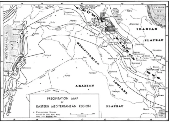
Fig. 1. Map of eastern Mediterranean region showing how precipitation is controlled by elevation and by proximity to the Mediteranean Sea. Data for Iran from GANJI ( 1 9 6 0 ) , for northern Iraq from DENNIS ( 1 9 5 3 ) , for Turkey from LEMBKE ( 1 9 4 0 ) , and for the rest of area from FISH &
T h e g r o w i n g evidence that the foothills a n d piedmont of the K u r d i s h mountains served as one principal locus for the beginnings of v i l l a g e life and the domestication of plants and animals (BRAIDWOOD, H O W E , et al., 1 9 6 0 ) d r a w s attention to the past p h y s i c a l and climatic environments that m a y have influenced this important cultural transformation. Although it seems reasonable that the Pleistocene a n d post-glacial climatic changes known to have occurred in Europe should be reflected in some manner in the N e a r E a s t , the proof of such changes must come from studies in the field. A very sensitive and at the s a m e time a wellrecorded climatic indicator is glaciation, so a first step in reconstruction of p a l e o -climate should be the study of Pleistocene glaciers in nearby mountains. B O B E K ( 1 9 4 0 ) had reported e x p a n d e d Pleistocene glaciers in the C i l o D a g h a r e a of Turkish K u r d i s t a n , D E M O R G A N ( 1 9 0 9 , p . 9 2 ) h a d referred to glacial features in the Z a g r o s ridges of Iranian Kurdistan a n d adjacent Luristan, but the geologists of the I r a q Petroleum C o m p a n y , who have traveled extensively in the high mountains of Iraqi K u r d i s t a n , never reported any glacial features in this region. T h e present p a p e r records new evidence for the extent of glaciation in these mountains, a n d reviews the older evidence.
Opportunities to study briefly the mountains of K u r d i s t a n c a m e to the writer in 1 9 5 1 , 1 9 5 4 - 5 5 , a n d 1 9 6 0 while he w a s attached to the prehistoric projects of the Oriental Insti tute (University of C h i c a g o ) . H e is indebted to the J o h n S i m o n Guggenheim M e m o r i a l Foundation a n d the Wenner-Gren Foundation for Anthropological Research for fellow ships, to R . J . BRAIDWOOD for providing supplemental funds from the Oriental Institute and the N a t i o n a l Science F o u n d a t i o n and for organizing base facilites and other indispen sable liaison, to colleagues on the projects for cooperation a n d assistance, to H . V . D u n -nington a n d R . V . Browne of the Iraq Petroleum C o m p a n y in K i r k u k for courtesies and geological a d v i c e , to L e o Anderson and C h a r l e s Simkins of the Khuzestan D e v e l o p m e n t Service, A h w a z , for loan of facilities and equipment, and to countless government offi-cialis a n d villagers for hospitalities and other aids.
Physical and climatic setting
T h e crest of the T a u r u s - Z a g r o s Mountains reaches elevations of more than 4 , 0 0 0 m above sea level in the C i l o D a g h in southeasternmost T u r k e y near the headwaters of the Grater Z a b R i v e r . T h e crest remains high at 3 , 0 0 0 - 3 , 5 0 0 m. e a s t w a r d along the I r a q - I r a n frontier in K u r d i s t a n for several km, then lowers to 2 2 0 0 - 2 8 0 0 m in the headwater region of the Lesser Z a b and D i y a l a Rivers. Still farther to the southeast in the Z a r d e h K u h of Iran the crest again locally attains elevations of 4 , 0 0 0 m, a n d then dies out in southern Iran.
T h e axis of the range consists largely of Paleozoic and Mesozoic metamorphic and volcanic rocks thrust o u t w a r d (to the southwest) over linear folds of Mesozoic limestone and T e r t i a r y terrestrial deposits. T h e folds r a n g e from symmetrical gently-plunging struc tures to steep-flanked flat-topped features etched by stream erosion and weathering to rugged ridges a n d precipitous gorges. T h e folds decrease in intensity outward in the foot hill zone, a n d as the M e s o p o t a m i a n L o w l a n d is approached they are confined to gentle structures in the Tertiary rocks.
T h e t o p o g r a p h i c forms closely reflect the geologic stratigraphy and structure. T h e metamorphic a n d volcanic zone consists of r u g g e d nonlinear ridges reaching elevations of 3 8 0 0 - 4 1 0 0 m. T h e belt of folds is marked by several topographic forms: long sweeping ridges and v a l l e y s made of successive hard a n d soff beds on the flanks of folds, b r o a d l y sloping anticlinal ridges giving w a y along the strike to sharp p a i r e d hogbacks where the fold crest is breached, and minor synclinal ridges. Important stratigraphic units expressed topographically in alternate ridges and v a l l e y s are ( 1 ) resistant massive T r i a s s i c and Jurassic limestones, ( 2 ) soft L o w e r Cretaceous m a r l s ( 3 ) resistant U p p e r Cretaceous lime stones, ( 4 ) generally soft U p p e r Cretaceous a n d Eocene thin-bedded limestones, marls,
136 H. E. Wright
red shales, a n d conglomerates, ( 5 ) resistant Eocene limestones ( 6 ) soft Miocene redbeds, a n d ( 7 ) Pliocene siltstones (soft) a n d conglomerates (locally resistant). Complications in these generalized relations are introduced by lateral facies changes in bedding of limestone, for example, a n d these are reflected in the t o p o g r a p h y by reduction in prominence of a particular ridge or valley.
T h e stratigraphic sequence a n d the structural relations indicate that uplift of the mountain belt started as early as the Eocene, and the onceextensive seas of this area a n d the Mesopotamian L o w l a n d became restricted to a l l o w formation of evaporite deposits. Accelerated uplift during the T e r t i a r y is recorded b y terrestrial Miocene and Pliocene deposits, locally thousands of feet thick; culmination of the orogeny produced not only the Pliocene conglomerates but also the expansion of the deformed zone so that the late T e r t i a r y sediments themselves were folded. Just h o w long the deformation persisted is not known, but it is possible that some of the river terraces and other Pleistocene l a n d -forms owe their genesis to continued crustal movements.
T h e master d r a i n a g e of K u r d i s t a n consists of four large transverse streams which head in the high mountains or the interior plateaus and flow transversely across the fold ridges to join the T i g r i s R i v e r along the axis of the M e s o p o t a m i a n L o w l a n d . T h e s e four streams -the Khabur, Greater Z a b , Lesser Z a b , a n d D i y a l a - - h a v e probably inherited -their transverse courses from their T e r t i a r y equivalents that deposited the late T e r t i a r y piedmont sedi ments, and are thus essentially antecedent streams. A s the individual anticlinal folds rose as potential barriers, the streams maintained their transverse courses by cutting sharp canyons, and repeated uplifted of the mountain belt periodically rejuvenated the streams. S o m e adjustments from such transverse courses are recorded by the short longitudinal subsequent segments, and by the f a c t that some of the ridge crossings are localized by plunges of the folds or by other f a v o r a b l e structures. There m a y also be some cases of autosuperposition from the less resistant younger sediments of the folded series onto the m o r e resistant Cretaceous limestones.
T h e climate of the T a u r u s - Z a g r o s mountain arc is typically Mediterranean but there a r e differences a l o n g its great length. Practically all the precipitation comes in the fall, winter, and spring. T h e storms are of t w o types ( B O E S C H 1 9 4 1 ) . T h e first type is p r o d u c e d b y cyclonic disturbances that h a v e traversed the length of the Mediterranean or h a v e regenerated in secondary low-pressure centers over C y p r u s at the front of outbreaks of p o l a r continental air from western Asis ( E L F A N D Y 1 9 4 6 ; B U T Z E R 1 9 5 8 , p. 2 2 ) . T h e s e storms move as c o l d fronts and are characterized b y strong winds a n d b y snow at a p p r o priate altitudes. T h e y are dominant in the coastal mountains and in the western T a u r u s , a n d they invade the interior along t w o principal tracks, one across the " S y r i a n S a d d l e " south of the T a u r u s arc, the second across the north-Palestinian u p l a n d to the H a u r a n a r e a south of D a m a s c u s . T h e invasions are common especially in the fall and spring, a n d the northern track occasionally carries the storms f a r eastward even to the Persian G u l f a n d Pakistan. T h e passage of these c o l d fronts of Mediterranean origin is followed b y periods of clear cold weather with strong winds as the cold air from the northern plateaus b r e a k s out over the border mountains onto the M e s o p o t a n i a n piedmont.
T h e second t y p e of storm is related to the A r a b i a n anticyclone, which reaches m a x i m u m development in mid-winter and becomes connected with the Asiatic high ( B O E S C H 1 9 4 1 ) . It serves as blocking high to the Mediterranean cyclones, but has its o w n precipitation pattern in the T a u r u s - Z a g r o s M o u n t a i n s , with gentle warm-front rains in contrast to the extreme storminess of the Mediterranean type. In the spring it breaks down and a l l o w s the passage of an increasing number of Mediterranean cyclones.
T h u s with these t w o types of storm the mountain belt is favored b y rain or snow from N o v e m b e r to A p r i l . T h e gentle winter rains in p a r t i c u l a r are vital in building up the soil moisture for the spring grain crop, a n d the spring storms add to the snow pack in the
T a b l e 1 Temperature and precipitation in southwestern Iran T E M P E R A T U R E ^ ) 0 C.
L A T . ELEV. N o . Mean Mean Mean Range ° m. Years Annual Jan. J u ' y
P I E D M O N T — Steppe and Hot Desert Steppe
P R E C I P I T A T I O N ^ ) N o . Annual Years mm. Abadan 30 6 9 25 12.4 36.2 24 8 157 Ahwaz 31 20 6 25.4 12 37 25 3 242 Shushtar 32 80 8 26.4 13.5 38.7 25 8 351 Gotvand 32 110 6 25.4 12.1 37.4 25 4 379 Dizful 32 150 7 25.9 13 4 38.3 27 6 402 Mesjid-i-Sul eiman 32 240 7 23.8 10 37.0 25 21 466 Qasr Sharin 34 330 3 21.9 8.6 33.6 4 382 Qasr Sharin
ZAGROS O U T E R RIDGES — Oak Forest
Sefid Dasht 33 1150 4 18.6 5.3 32.1 27
Khorramabad 34 1170 9 17.0 4.9 29.3 25 7 519
Elam 34 1400 13 733
Kerend 34 1600 6 14.6 3.1 26.8 24 4 703
Z A G R O S I N N E R R I D G E S A N D I R A N I A N PLATEAU — Steppe and Cold Di :sert Ste]
Dorud 33 1450 3 13.6 —0.6 27.9 28 Nehavand 34 1650 4 12.1 —0.9 24.5 25 Malayer 34 1750 7 295 Arak 34 1750 4 13.5 —1.7 27.2 25 7 313 Hamadan 35 1880 12 11.7 —1.1 24.0 25 11 359 Dareh Takt 33 1800 4 10.0 —5.5 22.3 28 Shahabad 34 1400 3 427 Kermanshah 34 1320 16 4.1 2.0 27.1 25 15 421 Bisitun 34 1360 3 13.4 0.7 26.5 26 Sahneh 34 1470 23 6 397 Ravansur 34 1500 5 13.5 1.6 24.6 24 4 734 Ahmavand 34 1600 3 13.0 0.8 25.1 Harsin 34 1700 27 4 530 Sanandaj 35 1650 12 15.3 1.3 28.6 12 537 Shamindej 36 1400 5 257 Rezaiyeh 38 1330 8 417 Tabriz 38 1360 9 283
(1) Data from Khuzestan Development Service, Ahwaz, Iran (2) D a t a from GANJI (1960).
T a b l e 2 Precipitation in northern Iraq
P R E C I P I T A T I O N ( i ) L A T I T U D E E L E V A T I O N Years Annual D J F N D J F
° N . m. No. mm.
%
%
ZAGROS P I E D M O N T AND MESOPOTAMIA — Steppe and Hot Desert Steppe
Baghdad 33 35 16 154 50 80 Diwaniya 32 18 23 233 55 78 Khanaquin 34 210 14 327 55 87 Mosul 36 245 29 382 55 81 Kirkuk 35 380 14 371 54 85 Erbil 36 400 15 518 54 79 Chemchemal 36 700 12 631 52 77
ZAGROS O U T E R RIDGES — Oak Forest
Zakho 37 420 17 837 51 78 Amadia 37 1235 13 900 40 69 Sursank 37 915 7 1049 54 77 Aqra 37 715 15 949 54 82 Shaqlawa 36 1050 7 1035 60 84 Ruwandiz 37 1005 15 1014 55 81 Suleimania 36 850 15 734 50 75 Bakrajo 36 730 12 825 46 72 Halebja 35 720 18 827 55 82 Penjwin 36 1400 11 1339 57 84
C ) Data from DENNIS (1953)
138 H . E. Wright
mountains. In fact B O E S C H ( 1 9 4 1 ) interprets three precipitation m a x i m a - - t h e fall and spring related to the Mediterranean storms, and the winter t o the A r a b i a n anticyclone. T h e scarcity of long-run stations in this region makes such close differentiation uncertain, however. B O B E K ( 1 9 5 2 , p . 7 0 ) places the mountain belt in his zone of spring/winter m a x i m u m and the piedmont in winter/spring.
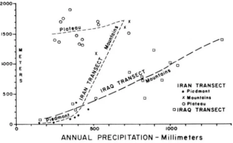
Precipitation in the T a u r u s - Z a g r o s Mountains and piedmont is controlled principally b y the general altitude of the land area. Within the mountain country, however, the precipitation does not reflect closely the elevation of individual stations—equal amounts fall on mountain ridges a n d intervening valleys, as illustrated b y the scatter of points on the precipitation/elevation curve for transects across the Z a g r o s ridges in I r a q a n d Iran (Fig. 2 ) . T o t a l precipitation rises abruptly from 2 5 0 - 4 0 0 mm ( 1 0 - 1 6 inches) in the pied m o n t to perhaps as much as 1 5 0 0 mm ( 6 0 in.) in the middle of the high mountains, but then decreases abruptly to 3 0 0 - 5 0 0 mm on the Iranian P l a t e a u ( T a b l e 1 - 2 ; F i g . 2 ) .
ELEVATION 2000 * ' a X / E < ± \ . ^ I R A N T R A N S E C T • Piedmont • X Mountains o Ploteou • I R A Q T R A N S E C T 900 1000
ANNUAL PRECIPITATION - Millimeters
Fig. 2. Relation of precipitation to elevation in two transects across the Zagros Mountains. Data in tables 1 and 2.
T h e maximum precipitation in the entire T a u r u s - Z a g r o s arc at present is in the high mountains of K u r d i s t a n in the southeastern corner of T u r k e y a n d adjacent I r a q (Fig. 1 ) . T w o factors are involved here. First, the mountains in this region are higher a n d more massive than elsewhere along the arc, for they exceed elevations of 3 , 0 0 0 m for a distance of almost 2 5 0 km. T h e y thus serve as a more effective barrier to moisture-bearing air masses moving against the mountains from Mesopotamia, whether the precipitation is associated with the passage of the Mediterranean cyclonic storms or with the occurrence of orographic or anticyclonic circulution produced by the A r a b i a n anticyclone. T h e second factor, which w o u l d seem to be effective primarily with respect to the Mediter ranean storms, is the rather a b r u p t curvature of the mountain arc just in K u r d i s t a n . T h e storms which cross the S y r i a n saddle from the Mediterranean h a v e a trajectory toward the northeast as they follow the flanks of the western and m i d d l e T a u r u s . A s thev reach the eastern T a u r u s they must be deflected to the southeast o r cross the m a s s i v e barrier a n d spread onto the Iranian P l a t e a u . T h e fact that relatively few of them m o v e very far o n t o the plateau is indicated b y the abrupt decrease in precipitation northeast of the mountains. In his study of precipitation relations in T u r k e y , L o u i s ( 1 9 4 4 , p . 4 7 7 ) pointed o u t that the contrast between the wet side and the dry side of mountain ranges is not g r e a t when the storms travel parallel to the ranges, but when storms a b u t directly or obliquely against a range the contrast is sharp. Thus in K u r d i s t a n the mountain volume a n d alignment are both f a v o r a b l e for high precipitation, with mean annual v a l u e s exceed ing 1 2 0 0 mm in some intermontane valleys and probably 1 5 0 0 m m at higher elevations.
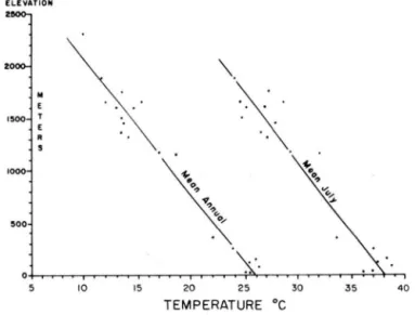
T h e mountains above 1,500 m generally h a v e continuous snow cover in winter, a n d the storage of this snow is a n important feature in the flood regime of the large mountain rivers. S m a l l glaciers and perennial snow patches persist in sheltered locations in the highest mountains, notably in the Cilo D a g h a r e a in southeasternmost T u r k e y a n d in the Zardeh K u h in Iran north of the head of the Persian Gulf. W i n t e r temperatures v a r y precisely with elevation ( T a b l e 1; Fig. 3). F e w villages are located within the mountains higher than 1,500 m, p r e s u m a b l y because of the winter snow.
E L E V A T I O N 2 9 0 0- 1
TEMPERATURE °C
Fig. 3. Vertical air-temperature gradient for 20 ground stations in transect from southern Meso potamia across Zagros Mountains to Iranian Plateau.
In the summer the zone of westerly cyclones moves n o r t h w a r d a n d the weather in the eastern Mediterranean region is controlled largely by a low-pressure system centering in the hot l a n d s around the Persian Gulf. T h e prevailing winds in Kurdistan a r e north a n d dry. R a i n rarely falls in the summer, a n d even clouds are uncommon. T e m p e r a t u r e s are high in the piedmont, w i t h daily m a x i m a generally exceeding 3 5 ° C from M a y to October. A b o v e about 1,000 m , however, s u m m e r heat is less intense and nights are cool. T h e great r a n g e in mean temperature between J u l y and J a n u a r y ( a b o u t 2 5 ° C ) is a reflec tion of the basic continentality of the climate ( T a b l e 1).
T h e climatic zones are closely reflected b y the vegetational relations. T h e lower tree-line has a moisture control. I t rises rapidly from sea level on the Mediterranean c o a s t to about 700 m elevation 50 k m inland from the coast, as the Mediterranean humidity decreases. E a s t w a r d through the M e s o p o t a m i a n piedmont for a t least 900 km the lower treeline remains at 7 0 0 - 1 0 0 0 m elevation, a n d m a r k s an annual precipitation of about 500 mm. L o c a l variations in the elevation of the treeline are c a u s e d by special factors. It is higher on hot south-facing slopes than on north-facing slopes, where the sun is not so bright. S m a l l valleys at l o w elevation within the higher mountains or close to the mountains m a y be forested because of the g r e a t e r precipitation engendered by the nearby mountains.
O a k (mostly Quercus persica) dominates the forest throughout the length of the mountains. C l o s e to the Mediterranean b e l o w 1000 m elevation, where the winters are mild, a s e p a r a t e zone of cold-sensitive types like Pinus brutia, o l i v e (Olea), a n d various h a r d w o o d shrubs occur below the main o a k forest. Farther east m a p l e (Acer), hawthorne (Crataegus), ash (Fraxinus), a n d almond (Amygdalus) are minor components in the o a k forest, especially in the lower p a r t . Pistachio (Pistacia) is co-dominant on certain d r y sites,
140 H. E. Wright
where fig (Ficus) also occurs. B l a c k pine (P. nigra) a n d juniper (J. excelsa) are c o m m o n in the main forest zone along with o a k in the western p a r t of the T a u r u s R a n g e , espe cially at higher elevations ( L o u i s 1939, p. 9 6 ) . E a s t w a r d s towards K u r d i s t a n pine d r o p s out; juniper extends barely into I r a q on the outer flanks of the Z a g r o s ridges, but on the inner margin of the inner m a r g i n of the forest is found farther east on the Iranian Plateau ( B O B E K 1 9 5 1 , p. 32).
Where the forest is undisturbed and well developed, as in the mountains above E l a m , the arboreal c o v e r exceeds 5 0 % over broad areas, but close to villages, trails, and m i g r a tion routes the o a k especially has been cut for charcoal, house beams, a n d summer shelters, a n d any seeding a n d sprouting h a v e been inhibited by the grazing of goats. O a k p r o p a gates by root shoots and therefore does not require full growth to the flowering stage to assure regeneration. It therefore has probably not been so easy for m a n to modify its gross distribution as in the case of other trees. Nonetheless, the lower treeline along the front of the K u r d i s h mountains next to the intensively inhabited piedmont steppe m a y h a v e been raised considerably b y these various disturbances, which h a v e been practiced for millenia. T h e occurrence of isolated trees far below the present treeline in exposed
2 A G R 0 S M O U N T A I N S j I R A N I A N ^ P L A T E A U
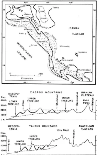
Fig. 4. Generalized map and cross-sections to show relation of treelines to elevation and geogra phic position in the Taurus-Zagros Mountains and adjacent regions.
localities protected by some ceremonial t r a d i t i o n implies more extensive w o o d l a n d s in the past.
T h e upper treeline on the outer ridges h a s an elevation of a b o u t 2,000 m a l o n g the entire length of the T a u r u s - Z a g r o s mountain a r c from the Mediterranean to southern Iran. Its position is p r o b a b l y controlled by winter temperature, for there is no indication that moisture is deficient at this elevation. T h e precipitation at this treeline is p r o b a b l y at least 1,200 m m . A b o v e the treeline is an alpine zone of herbs and l o w shrubs.
In addition to the lower a n d upper treelines on the outer Z a g r o s ridges, there is an inner treeline that reflects p r i m a r i l y the decrease in moisture on the lee (northeast) side of the border mountains and on the Iranian P l a t e a u , This treeline, like the lower treeline on the outer ridges, follows roughly the 500 m m precipitation line ( F i g . 4 ) . Its position depends p r i m a r i l y on distance from the a x i s of the high montains. Where the Z a g r o s ridges are n o t high enough to have a continuous alpine zone, the inner treeline occurs about 75 k m i n l a n d from the outer flank of the r a n g e , as in the segment from K e r m a n s h a h to K h o r r a m a b a d in Iran. T h e elevation of the inner treeline in this sector is about 1,300-1,500 m. Where the main mountain m a s s is entirely a b o v e treeline, as in the C i l o D a g h - A l g u r d D a g h area under special consideration in this p a p e r , the cold-dry p l a t e a u steppe essentially merges with the cold-moist alpine zone, and the t w o cannot be easily distinguished. T h e s e cold steppes are characterized by the great frequency of perennial herbs, whereas the hot steppe of the M e s o p o t a m i a n piedmont has such hot summers that m a n y perennial herbs cannot survive, and the relatively short spring growing season f a v o r s annual herbs (PABOT 1 9 6 0 ) .
Algurd D a g h area
T h e crest of the Zagros R a n g e along the I r a q - I r a n frontier northwest of the R u w a n d i z River includes several ridges a n d summits reaching elevations of 3,000-3,500 m a b o v e sea level. A m o n g these are A l g u r d D a g h , H a w a r j u K u h , and S i a h K u h (Fig. 5, 6 ) . T h r e e valleys leading to the west from the crest d r a i n eventually into the R u w a n d i t z R i v e r , which is a p r i n c i p a l tributary of the Greater Z a b River. These three valleys are occupied respectively b y the three principal villages B o l a , Birkim, a n d Beni, and they will be described under these names.
Fig. 5. Map of Algurd Dagh area and Ruwandiz River area in Zagros Mountains, Iraq-Iran. Small crescents show Pleistocene glcial cirques. Area of Figure 6 outlined by rectangle.
142 H . E . Wright
o, ,io
Kilometers
Fig. 6. Map of Algurd Dagh area, Iraq-Iran, showing distribution of glacial deposits (stipple) and cirques (small crescents).
B o l a V a l l e y
T h e village o f B o l a is located at an elevation of about 1500 m a b o v e sea level just outside the m o u t h of a b r o a d basin-like valley h e a d that is filled with glacial d e p o s i t s . T h e stream that drains the basin enters a sharp g o r g e about 100 m deep just u p s t r e a m from Bola, a n d irrigation canals are led from the h e a d of the g o r g e to water the rice fields on the terrace on which the village is located. T h e basin is a b o u t 5 km b r o a d a n d is known by the local people as H o r n e r . T h e elevation of its floor rises from about 1 5 0 0 m near its mouth to a b o u t 2500 m at the inner e d g e ; then begins the steeper slope l e a d i n g to the crest. T h e u p p e r tree limit in this region is a b o u t 1800 m.
T h e basin floor has an irregular rolling t o p o g r a p h y with few rock outcrops—typical of glacial deposits. O n e small l a k e about 100 m in diameter is located at an elevation o f about 2,500 m near the base of the south wall o f the basin, and another lake is r e p o r t e d closer to the h e a d w a l l . M a n y m e a d o w s in flat depressions suggest the former existence of other undrained depressions. T h e material c o m p o s i n g the basin floor consists of g l a c i a l till, and includes fragments m o s t l y of metamorphic rock derived from the basin r i m -schist, slate, grit, limestone, volcanic breccia, red siltstone, etc.
Numerous s m a l l cirques are located on the h e a d w a l l of the H o r n e r basin below A l g u r d D a g h and H a w a r j u K u h at estimated elevations of 2,700 m, a n d glaciers from these cirques p r e s u m a b l y fed the main ice mass that must h a v e filled the H o r n e r basin. O t h e r cirques can be f o u n d at lower elevations in the B o l a V a l l e y , however, a w a y from the headwall region. F o r e x a m p l e , on the south-facing slope of B a r d i S p i , which is the r i d g e on the north side of B o l a V a l l e y , four small cirques were identified at elevations of 1 7 0 0 , 2000, and 2 1 0 0 m. O n the o p p o s i t e side of B o l a v a l l e y two cirques are l o c a t e d a t
1700 m and a third, near the pass over the ridge to the Rust V a l l e y , has a floor at a b o u t 1450 m. T h e s e cirques are considered to be the work of small cliff glaciers, a n d their positions give an indication of the elevation of the Pleistocene snowline.
N o distinct looped moraines could be recognized in Horner basin, except at the v e r y h e a d of the v a l l e y where a tongue of young drift with apparently fresher features origina ted in the sheltered recess north of A l g u r d D a g h a n d extended for a b o u t 4 km d o w n into the center of the basin to an elevation of a b o u t 2 0 0 0 m.
B i r k i m V a l l e y
T h e village of Birkim is l o c a t e d at a c o m p a r a b l e position to B o l a in a valley farther north. T h e v i l l a g e is perched on a terrace a p p r o x i m a t e l y at the entrance of the b r o a d l y e x p a n d e d glaciated head of the valley. Its elevation is about 1400 m a b o v e sealevel, close to the upper limit of year-round habitation in this area. D o w n s t r e a m form the v i l l a g e the valley is n a r r o w and is cut in bedrock. T h e e x p a n d e d valley u p t r e a m is called B i r k i m a , a n d serves as excellent pasture area for n o m a d i c a n d semi-nomadic groups of sheep-, g o a t - , and horse-breeders. S m a l l fields are c u l t i v a t e d above the v i l l a g e to about 2 1 0 0 m.
Birkima is floored by irregular glacial drift. N o distinct moraines are evident, but there appear to be three breaks in the level of the floor that might represent successive ice-front positions a b o v e about 2 4 0 0 m elevation. T h e t o p o g r a p h y is particularly hum-mocky. T w o lakes occur at a b o u t 2400 m. O n e of them, called D i n d a r a L a k e , has a d i a meter of about 2 0 0 m. It suddenly overflowed a few years a g o : its outlet stream cut a deep channel, exposing 6 m of drift, and then built a large boulder fan below. A rather steep 150 m d r o p leads from a b o u t 2400 m d o w n to a less hummocky zone, which descends g r a d u a l l y to about 1900 m. L a k e s in this a r e a were discovered a t elevations of 2 4 0 0 a n d 2 1 0 0 m in addition to many m e a d o w s . Patches of outwash gravel were found as high as 2 1 0 0 m. Another steep d r o p leads to the final zone, which descends more g r a d u a l l y to a b o u t 1500 m a n d contains small ponds or u n d r a i n e d depressions at 1700 a n d 1550 m. B e l o w 1500 m the surface a g a i n drops r a p i d l y t o the mouth of B i r k i m a near the v i l l a g e , where the river exposes a 10 m section of till a t a n elevation of a b o u t 1300 m.
T h e color of the till is v a r i a b l e and reflects the local bedrock—gray slate and sandstone, green volcanic rocks, red chert a n d slate, g r a y limestone and diorite. L a r g e knobs project a b o v e the till surface, but the regional structure is so complex that it is difficult to deter mine whether these knobs are bedrock or s i m p l y large till blocks. T h e gray till at a b o u t 2 4 0 0 m elevation is oxidized to a depth of a b o u t 1 m.
B e n i V a l l e y
T h e village of Beni, as is the case with the other two valleys, is located a p p r o x i m a t e l y at the point where the broad v a l l e y head becomes constricted. It has an elevation of a b o u t 1500 m, and probobly represents the a p p r o x i m a t e limit of continuous glacial deposits. Although there are no lakes or deep exposures of till in this b r o a d valley head, a thick filling of glacial deposits is suggested by the lack of bedrock ledges on the floor, b y the rolling t o p o g r a p h y , and by the cirques on the ridges bordering the valley head.
S i d e k e A r e a
Beni valley and Bola valley descend a p p r o x i m a t e l y 5 km from the respective villages a n d join near the larger v i l l a g e of Sideke, which is located on a 30 m terrace at a n ele v a t i o n of about 950 m a b o v e sea level. Other terraces in the a r e a are as great as 60 m a b o v e the present river. T h e y contain coarse gravels, including boulders 1 m across. In consideration of the facts that the Sideke a r e a is a great distance from the high m o u n tains and that large streams of competence sufficient to carry such l a r g e boulders no longer exist here, it seems likely that the gravels are glacio-fluvial, and that the ice front stood
144 H. E. Wright
close by. T h i s conclusion is s u p p o r t e d by the occurrence of till a t a b o u t 1 1 0 0 m near the village of Birte about 3 km upstream (southeast) from Sideke on a low ridge just a b o v e the terraces.
Ruwandiz River area
In addition to the Pleistocene glaciers of the A l g u r d D a g h a r e a , several other centers were located elsewhere in the high mountains of northeastern I r a q but were not carefully studied or m a p p e d . Most of these are in the d r a i n a g e area of the R u w a n d i z River, one of the principal left-bank tributaries of the Greater Z a b . T h e R u w a n d i z River heads near the Iranian frontier among the high ridges that locally reach elevations of 3 0 0 0 - 3 5 0 0 m a b o v e sea level. These ridges contain small fresh cirques in sheltered locations, but the associated glacial deposits are not well displayed in the valleys below, and it seems likely that the most recent glaciers d i d not fill these v a l l e y s . D o w n s t r e a m the river leaves the metamorphic zone and crosses successively lower ridges of the f o l d zone; none of these ridges shows clear signs of glaciation.
G a l a l a V a l l e y
A distinct cirque occurs at an elevation of a b o u t 1900 m in a 2400-3000 m ridge at the head of G a l a l a valley, which joins the right b a n k of the R u w a n d i z about 4 k m a b o v e the fold zone. A possible cirque exists on the north-facing slope of this valley at about 1400 m. N e a r the mouth of the v a l l e y is a coarse gravel terrace which is probably g l a c i o -fluvial.
M a r a n a V a l l e y
O n the opposite (left) side of the R u w a n d i z R i v e r is a tributary draining west past the villages of M a r a n a and N a o p u r d a n . This t r i b u t a r y valley is bordered on the south by a high ridge ( C h i a - i - M a n d a u or S a k r i S a k r a n ) a t 3000-3500 m. ' i t least 13 cirques are
Fig. 7. Moraines at the head of Marana Valley.
located high on the sheltered northern slope of this ridge; some contain linear moraines or rock glaciers which stream d o w n rugged slopes to an estimated elevation as l o w as 2000 m (Fig. 7 ) . T h e northern flank of M a r a n a V a l l e y leads up to a 2100-2400 m r i d g e ; here the t o p o g r a p h y is confused because of the irregular structure of limestone, but one deep cirque-like form with several small lakes occurs with floor a t an estimated elevation of 1800 m. T h e north flank a n d floor of M a r a n a V a l l e y itself is covered with till-like debris cemented in the upper few feet to resistant breccia. Below a b o u t 1800 m the floor
becomes deeply entrenched, a n d near the v i l l a g e of M a r a n a m o r e than 30 m of the encrusted debris are exposed along the stream. D o w n s t r e a m the former valley floor p e r sists as shoulders about 150 m a b o v e the present M a r a n a River, a n d has a n elevation of a b o u t 1200 m near the junction of M a r a n a v a l l e y w i t h the U u w a n d i z valley.
T h e debris on the flanks and floor of M a r a n a v a l l e y is interpreted as pure g l a c i a l till, although it is recognized that alternatively the m a t e r i a l may h a v e originated as l a n d slide debris from the limestone ridges to the north. T h e bedrock of M a r a n a V a l l e y itself is not well enough exposed to discern lithology f a v o r a b l e for landsliding. T h e heavy cemen tation of the debris a n d the smoothness of its t o p o g r a p h i c forms suggests that if this debris is till it m a y represent a stage of glaciation before the last, although the a b u n d a n c e of calcareous ground water and soil water on the north flank of the v a l l e y , coupled with the summer aridity, might p r o v i d e conditions c o n d u c i v e to crust formation in a relati vely short period.
R u w a n d i z H e a d w a t e r s
T h e R u w a n d i z R i v e r V a l l e y itself contains terraces and other features of p r o b a b l e or possible glacial origin. T h i s river heads in the frontier region a b o v e R a y a t , flows across the metamorphic zone to R a z a n , thence across several limestone f o l d ridges through the Berserini G o r g e to the edge of the D i y a n a P l a i n , which is localized by the broad o u t c r o p of Gretaceous shale. T h e river then enters the R u w a n d i z Gorge as it obliquely crosses the next limestone anticline, and then follows the n e x t syncline westward for m a n y miles b e fore joining the Greater Z a b River at the entrance t o Bekhme G o r g e .
R a y a t has an elevation of about 1 1 0 0 m a b o v e sea level, a n d the R u w a n d i z R i v e r Valley a b o v e R a y a t is open in much the same w a y a s the valleys a b o v e Birkim, B o l a , a n d Beni described previously. T h e open slopes, h o w e v e r , are more smoothly g r a d e d a n d are not m a r k e d b y the irregular glacial knobs a n d m e a d o w s which characterize those other v a l l e y s . Phyllite crops out at m a n y localities, but the cover of debris contains m a n y erratic stones a n d a thin soil. Bedrock lithology a n d structure are not conducive to l a n d s liding extensive enough to explain the b r o a d v a l l e y opening, and it seems likely that the main erosion w a s accomplished by glaciation. T h e relatively smooth g r a d i n g of the slopes, however, suggests that the glaciation w a s older than that recorded in the Birkim a n d B o l a v a l l e y heads. T h e frost climate of the last g l a c i a t i o n m a y have led to smoothing o f the slopes a n d stripping of the soil. T h e ridges close t o the R a y a t a r e a reach elevations of only 2 1 0 0 - 3 0 0 0 m a n d m a y not have s u p p o r t e d glaciers large enough during the last glacial phase to fill the R a y a t area. Small cirques on these ridges in sheltered localions, however, m a y be referred to the last glaciation. O n e on the ridge 3 k m west of R a y a t , with eastern expousure, has floor at about 1500 m. T h e sharp 2400 m ridge south of R a y a t (i. e. north of M a r a n a V a l l e y ) has several small cirques with northern exposure at 2 1 0 0 m a n d a main cirque at about 1500 m. T h e m o r a i n e debris from this larger cirque a c t u a l l y reaches the v a l l e y floor near R a y a t .
Other cirques are visible on the frontier ridges east of R a y a t , particularly clustered on northern exposures on the 2 7 0 0 - 3 0 0 0 m ridges near the head of M a r a n a V a l l e y , but the d r a i n a g e from these cirques leads to the I r a n i a n side rather than to the R u w a n d i z R i v e r . T h e low pass at the frontier at the h e a d of the R a y a t area has a n elevation of o n l y a b o u t 1775 m. T h e frontier ridge 8-10 km north of R a y a t ( 3 0 0 0 - 3 3 0 0 m ) w a s not e x a m i ned, but it is doubtful that large glaciers f o r m e d on its southern slopes during the last glacial phase of the Pleistocene.
T h e village of R a y a t itself is located o p p o s i t e a nicely exposed terrace at the junction of the t w o main tributaries that form the R a y a t opening. T h e terrace is about 30 m high a n d contains coarse boulders and poorly sorted sediment that a p p e a r s to be glacio-fluvial. A few k m a b o v e R a y a t the terrace is undissected, a n d its surface g r a d e s u p w a r d l a t e r a l l y
146 H . E. Wright
to the footslopes of the ridges. If the terrace g r a v e l is the deposit of an older g l a c i a t i o n , it m a y thus be o v e r l a p p e d on the flanks by slope debris carried b y solifluction during the last glacial p h a s e .
M a r a n a - G a 1 a 1 a - R a z a n S e g m e n t
D o w n s t r e a m from R a y a t the R u w a n d i z R i v e r traverses a n a r r o w segment for a b o u t 10 km in which no terraces are preserved.
Below this n a r r o w segment the valley opens as the b r o a d entrance of the M a r a n a Valley is a p p r o a c h e d on the left bank. T h e R u w a n d i z River is crowded to the right by two thick masses of debris emanating from the end of the ridge north of M a r a n a V a l l e y . Each fan-like protrusion is a b o u t 3 km broad as it meets the R u w a n d i z . T o g e t h e r they have occasioned a sharp descent of about 100 m in the river gradient here along its toe (Fig. 8, 9 ) . T h e surfaces of the protrusions h a v e an elevation of about 1100 m near the river, and a p p e a r from the distance to have an irregular t o p o g r a p h y . Exposures in several river cuts at least 6 m deep show a greenish-gray clayey till-like material. A t places this rests on dissected terrace gravels of the main river, and at one exposure 2 km u p s t r e a m from the entrance of the G a l a l a River the c l a y e y "till" is s e p a r a t e d from the underlying
Fig. 8. Ruwandiz River upstream from entrance of Marana River (foreground). Note two lobes of landslide debris that have pushed river to the right bank.
l
I I
f~, ; — ----Landslide ?r r
f f (
7 / / // > > W
-^ 7 7 7 7 7 7 ' */ / / 1 1 i i t 0 1 0 2 0 K i l o m e t e r * 3 0 4 0Fig. 9. Profile of Ruwandiz River from Rayat to Diyana Plain, showing height of terrace rem nants and relation to Marana landslide lobe. Dotted line shows inferred profile for main
river gravel a n d its associated colluvium by a red soil. T h e clayey "till" is overlain in turn by younger soil and colluvium.
T h e s e two protrusions are tentatively interpreted as landslide masses rather than glacial debris, on the basis of three lines of evidence.
(1) T h e scars in the limestone ridge to which they m a y be traced face unsheltered to the south a n d h a v e an elevation of only about 1800 m. T r u e cirques of c o m p a r a b l e ele vation in this a r e a all occur in sheltered exposures facing north or northeast.
(2) A portion of the area adjacent to the limestone ridge is underlain by shale, a rock t y p e favorable for landsliding.
(3) T h e terraces of the R u w a n d i z River in this area seem not to be outwash terraces g r a d e d form these till-like masses; rather they are older, and were dissected before being overridden b y the protrusion. T h e debris masses thus were relatively d r y (like landslides but unlike glaciers) and did not s u p p l y enough w a t e r a n d sediment for valley alluviation. Interpretation of the relations in this area near the mouth of M a r a n a Valley is c o m p l i cated by the occurrence of another possible till within the terrace g r a v e l s . This material is light brown rather than greenish g r a y and is s a n d y rather than clayey. I t was a p p a r e n t l y derived from upstream rather than from the sedimentary rocks of M a r a n a V a l l e y , a n d is provisionally considered to be the deposit of a glacier which fed the extensive g r a v e l terraces from this region downstream all the w a y to the D i y a n a P l a i n .
O n the v a l l e y flanks above the river terraces in this region occur some sloping benches of resistant limestone slope-breccia. T h e s e benches rise far up the slopes as smooth surfaces, but at places are deeply dissected. In the area near R a z a n , just a b o v e the entrance to the Berserini G o r g e , some breccia benches m a y be traced up to great scars on the limestone cliffs, and a p p a r e n t l y originated as rock falls a n d landslides over the shale slopes that border the limestone ridges. F r a g m e n t s of breccia are secondarily deposited in the terrace gravel. In the R a z a n area a younger landslide d o w n into the v a l l e y bottom p r o d u c e d a mass of debris that contains fragments from the s l o p e breccia, rounded cobbles from the terrace gravels, a n d chunks of old soil, all in a c l a y e y matrix. Occurrences such as this, where the slippery shale bedrock is known to be present and where the ridge north of R a z a n is p r o b a b l y not high enough (with southern exposure) to h a v e nourished glaciers, permit a fairly certain assignment to landsliding.
T h e geomorphic history of the M a r a n a - G a l a l a - R a z a n segment of the R u w a n d i z R i v e r valley m a y be summarized as follows (Fig. 1 0 ) :
1. F o r m a t i o n of slope breccia in areas of limestone, rock falls from limestone cliffs, landslides where shale occurs.
2. Entrenchment of R u w a n d i z River, leaving breccia as benches.
3. G l a c i a t i o n in the higher ridges of the metamorphic zone. Glaciers probably filled M a r a n a V a l l e y , G a l a l a V a l l e y , a n d the main R u w a n d i z V a l l e y as far downstream as the G a l a l a region. Deposition of outwash g r a v e l s down the main stream, with some contribution from side slopes.
Fig. 10. Generalized composite cross-section of Ruwandiz River valley near mouth of Marana Velley showing inferred relation of Marana landslide to main glacio-fluvial terrace. 10 •
148 H . E. Wright
4. Entrenchment of R u w a n d i z River downstream from M a r a n a area, leaving the outwash fill as a terrace about 40 m high.
5. Second glaciation, confined largely to cirques in sheltered locations but as low as 1400 m. L a n d s l i d e s reached mouth of M a r a n a V a l l e y from limestone ridge to east and blocked R u w a n d i z River.
6. L a t e stage of glaciation caused small cirques at 2 7 0 0 - 3 0 0 0 m high on the walls of larger cirques on C h i a - i - M a n d a u south of M a r a n a Valley.
B e r s e r i n i G o r g e
T h e R u w a n d i z River in the segment of the Berserini G o r g e through part of the lime stone fold belt is m a r k e d by a continuation of the gravel terraces found between G a l a l a a n d R a z a n . T h e elevations of about 9 terrace remnants over a distance of about 20 km were measured; the m a x i m u m height of most patches is about 40 m above the river, al though some g r a v e l s were found as high as 60 m a b o v e the river. In several cases a t least 30 m of g r a v e l is exposed, so the terraces must be considered as depositional features formed after an earlier deep cutting of the v a l l e y . T h e gravels consist of rounded pebbles and cobbles ( a n d locally boulders) of metamorphic and igneous rocks from the higher ridges upstream as well as limestone from the local ridges. Interfingered with the rounded river gravels a r e lenses of colluvium contributed from the adjacent slopes. T h e terrace surfaces themselves are overlain by colluvium, which forms a smoothly graded s l o p e up to bounding ridges.
T h e relative antiquity of the gravel terrace is suggested by the extensive unconfor mable overburden of colluvium. A t one locality, 7 km upstream from the J i n d i a n bridge, the eroded terrace gravel is overlain on the slope by colluvial rubble, a red soil, a n d several meters of stratified sand and silt ( F i g . 1 1 ) . It appears here that the terrace g r a v e l , which reaches a m a x i m u m height of 55 m a b o v e the river, was cemented and then cliffed by partial river entrenchment. Colluvial rubble formed beneath the cliff, with
contribu-Fig. 11. Sketch cross-section across Ruwandiz River near Berserini, showing patch of lacustrine (?) deposits set in an old channel cut into glacio-fluvial terrace gravels.
tions from black limestone bedrock as well as from the terrace conglomerate, a n d then red soil formed on the stabilized colluvium. T e m p o r a r y damming of the gorge ( p e r h a p s by a landslide) caused deposition of sand and silt in slack water. Renewed intrenchment, with slight shift in channel position, left the silt filling perched on the valley side.
D i y a n a P l a i n
N e a r the exit from the Berserini G o r g e the terrace gravels are found at generally greater m a x i m u m heights, and a b o v e the J i n d i a n bridge on the edge of the D i y a n a P l a i n gravel was found as much as 110 m above the river. A n even m o r e impressive remnant of stream activity is a 25 m section of sand a n d basal gravel resting unconformably on Cretaceous shale on the top of an isolated hill a b o v e the R u w a n d i z River at the southeast end of the D i y a n a Plain opposite the town of R u w a n d i z (Fig. 12). T h e top of the remnant
5 K i l o m e t e r s 10 ' =
Fig. 12. Bent cross-section of Ruwandiz River gorge and Diyana Plain, showing relation of breccia bench and sand-capped hill to gravel terraces of Ruwandiz River. Elevations from British
Indian Survey maps and by altimeter.
is 250 m a b o v e the river. T h e basal g r a v e l contains cobbles a n d boulders derived from the metamorphic zone of the frontier ridges, a n d w a s certainly deposited by the R u w a n d i z River. T h e sand contains carbonate concretions, cemented layers, beds of laminated silt, a n d a 2 cm layer of limestone.
At a still higher level a b o v e the D i y a n a P l a i n , protruding from the smooth southwest flank of the beautiful anticlinal ridge ( K o z i k D a g h ) north of the village of D i y a n a , is a prominent bench of resistant limestone breccia at least 15 m thick resting on Cretaceous shale. T h e remnant projects 1.5 km out from the mountain a n d has an elevation a t about 1000 m a b o v e sea level at its outer edge—420 m above the river at Jindian only 2 km a w a y . S c a r s on the anticlinal ridge show the source of the limestone debris. C o m p a r a b l e breccia benches occur on the opposite (northeast) flank of the s a m e anticlinal ridge, at H a v d i a n on the opposite side of the D i y a n a Plain, and at m a n y other localities on the limestone ridges of the fold zone. T h e r e l a t i v e antiquity of the forms is indicated not only by their height a b o v e the present d r a i n a g e s but also, in the case of the H a v d i a n occurrence, b y the existence of a Mousterian c a v e (Babkhal) in the breccia (BRAIDWOOD,
H O W E , et al., 1960, p. 29, 6 0 ) .
Both the breccia remnants and the 2 5 0 m-high alluvial remnant opposite R u w a n d i z are p r o b a b l y much older than the gravel terraces of the Berserini gorges, a n d m u s t date from the e a r l y Pleistocene.
R u w a n d i z G o r g e a n d K h a l a n V a l l e y
After crossing the southeast edge of the D i y a n a Plain the R u w a n d i z River enters the famous R u w a n d i z Gorge, a n d obliquely crosses a limestone anticline for about 15 k m in a canyon as much as 1000 m deep. It then flows longitudially along the next synclinal valley (the K h a l a n Valley) for 10 km, a n d in this segment shows well-developed terraces as much as 100 m above the river. These terraces carry a cover of up to 15 m of gravel rich in quartzite cobbles, a n d are overlain b y limestone rubble g r a d e d from the adjacent ridges.
It is not possible at present to relate the R u w a n d i z terraces of this longitudinal segment to the terraces of the Berserini Gorge and thus to mountain glaciation. T h e K h a l a n terra ces are p r i m a r i l y erosional rather than depositional features: the alluvial cover is rela tively thin. I t is quite possible that these terraces record intermittent uplift of the high land area a n d are not climatically controlled.
T h e R u w a n d i z River in K h a l a n V a l l e y meets the Greater Z a b River, which follows the same synclinal valley from the opposite end. T h e Greater Z a b then turns a t a right angle to cross the next anticlinal ridge, B e r a t D a g h , via Bekhme G o r g e , and emerges onto
150 H. E. Wright
the rolling A s s y r i a n piedmont. T h e n c e it traverses l o w folds in T e r t i a r y conglomerate a n d siltstone, a n d constructs numerous erosional terraces with gravel veneers. T h e terrace topography g r a d u a l l y disappears downstream as the terrain becomes gentler towards the Tigris River, a b o u t 125 km from Bekhme G o r g e . T h e Z a b terraces in the Assyrian p i e d mont m a y also be tectonic rather than climatic.
S u m m a r y a n d C o n c l u s i o n s
T h e gorges a n d valleys of the R u w a n d i z R i v e r contain the best exposed and most accessible Pleistocene terraces a n d associated colluvial deposits of a n y area in the m o u n tains of northeastern Iraq.
T h e oldest Pleistocene deposits of the area are small benches of limestone breccia on the flanks of some of the limestone ridges. T h e y represent old slopes a n d valley floors formed when the drainage level w a s as much as 4 0 0 m above the present.
T h e terraces of the lower p a r t of the R u w a n d i z R i v e r and in the Greater Z a b R i v e r below the junction are probably also middle or early Pleistocene, but they may be tectonic rather than glacial-climatic.
T h e gravel terraces and intercalated colluvial deposits of the R u w a n d i z River in the Berserini G o r g e a n d upstream in the metamorphic z o n e are generally 30-50 m a b o v e the river. They are believed to be outwash deposits associated with a Pleistocene glacial p h a s e earlier than the last. T h e glacial drift itself m a y be represented by till beds in the terrace deposits near G a l a l a at an elevation of ICOOm, b y the encrusted debris in the dissected old floor of the M a r a n a V a l l e y tributary, and b y the smoothed till veneer in the o p e n head of the R u w a n d i z V a l l e y a b o v e R a y a t .
T h e last m a i n glacial phase of the Pleistocene is represented by small cirques on shel tered slopes a t elevations as low as 1500 m a n d p r o b a b l y even 1400 m and by l a r g e r cirques at 2 1 0 0 - 3 0 0 0 m. Fresh hummocky moraines a r e generally confined to the area just below cirques, but were found at elevations as low as 1200 m near R a y a t . On the basis of topographic expression and elevation range, this glaciation is corelated with the last glacial phase.
Very high small upper-story cirques at 3000 m on the high ridge south of M a r a n a V a l l e y are assigned to very recent glacial erosion.
Cilo Dagh area
T h e C i l o D a g h ( J e l o D a g h ) a n d S a t D a g h in southeastern T u r k e y comprise the v e r y highest sector of the T a u r u s - Z a g r o s mountain arc in K u r d i s t a n . T h e crests here reach 3800-4100 m a b o v e sea level but form neither the T u r k i s h - I r a q political boundary nor the drainage d i v i d e . T h e Iraq frontier extends a l o n g the fold belt a few km to the s o u t h ; the two main h e a d w a t e r tributaries of the Greater Z a b River h a v e their sources in the Anatolian P l a t e a u to the north a n d cut through the metamorphic zone to the longitudinal valley that the Greater Z a b follows as far as the junction with the R u w a n d i z R i v e r in the K h a l a n V a l l e y previously described.
Present a n d Pleistocene glaciers of the C i l o D a g h and S a t D a g h were studied b y B O B E K (1940). H e calculated the elevation of the present snowline in the area f r o m 20 small glaciers which persist in the sheltered high valleys. T h e measurement was m a d e in two w a y s : ( a ) average elevation between the terminus of the glacier and the crest of the ridge a b o v e the cirque, and (b) elevation of the lowest snow patches at the end of the melt season of observation ( 1 9 3 7 ) . T h e two types of measurement generally agreed a n d g a v e the following averages for the C i l o D a g h .
N o r t h slope, excessive shade 3 1 0 0 m N o r t h slope, a v e r a g e shade 3 3 0 0 m
B O B E K also m a p p e d the distribution of Pleistocene glaciers in these two ranges. T h e longest glacier w a s 10 k m ; one of the ice tongues reached an elevation of 1800 m. F o r the determination of Pleistocene snowline, he used the first of the t w o methods mentioned above—the a v e r a g e elevation between the Pleistocene moraines a n d the cirque ridges—and obtained the following averages for the Cilo D a g h :
N o r t h and northeast slopes 2 6 0 0 m West slopes 2 5 0 0 - 2 7 0 0 m South slopes 2 9 0 0 - 3 0 0 0 m
F r o m these figures an average of 7 0 0 m was presented by B O B E K for the depression of the snowline during the Pleistocene. H e c o m p a r e d this figure with the 1200 m usually assumed for the A l p s , and suggested that the difference was the result of a drier climate. In fact he used this relation as evidence that there was no increase in precipitation in the Pleistocene in Iran.
Fig. 13. Map of Cilo Dagh area, Taurus Mountains, Turkey, showing distribution of Pleistocene glacial features.
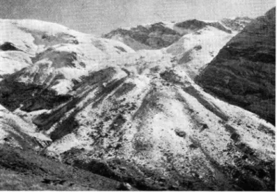
T h e writer's explorations in this region of the eastern Taurus of T u r k e y were confined to the region north and northwest of the C i l o D a g h (Fig. 13). T h e active glaciers a n d Pleistocene features of the high C i l o D a g h as m a p p e d by B O B E K where not visited, but Pleistocene glacial features were f o u n d over a b r o a d area in a n d adjacent to the Greater Zab River valley a t much lower elevations than those recorded b y B O B E K .
A 2 7 0 0 - 3 0 0 0 m ridge north of a n d parallel to the high Cilo D a g h bears a blanket of moraine over its entire north flank. T h i s range (called K a n d i l D a g h on B O B E K ' S m a p ) is all a b o v e the tree line and bears a lush cover of tall grasses and herbs in the spring. S m a l l bedrock knobs a n d short ridges project above the debris-covered slopes; at least one ridge