6 Available online at www.ijiere.com
International Journal of Innovative and Emerging
Research in Engineering
e-ISSN: 2394 - 3343 p-ISSN: 2394 - 5494
Technical Evaluation of Rural Infrastructure Scheme
Navazhushen N. Patel
1, Mr Nayan P. Soni
2and MahmedHusain Y. Patel
3 1Student, Civil Engg. Dept., S.V.M.I.T., Bharuch, India, [email protected] 2Assistant Professor, Civil Engg. Dept., S.V.M.I.T., Bharuch, India, [email protected]3Student, Civil Engg. Dept., S.V.M.I.T., Bharuch, India, [email protected]
I. INTRODUCTION
The government of Gujarat has launched competition program for smart village development plan 2016. [Source: Smart Village Scheme Guideline, https:// smartvillage.gujarat.gov.in/] In Bharuch district, 26 [Source: Smart Village Scheme Guideline, https:// smartvillage.gujarat.gov.in/] villages have been nominated by the state government to be developed as a smart village. The vision of Mahatma Gandhi – “The best, quickest and most efficient way is to build up from the bottom. Every village has to become a self-sufficient republic. This does not require brave resolutions. It requires brave, corporate, intelligent work.
II. SCOPE OF THE STUDY
The study will focus on the development trend, intensity of growth of the village, and find out the problems related to the physical development of the area, infrastructure services, and the administrative systems of the village. The study of the village gives the reason where there is need of sustainable facilities like infrastructure facilities, pure, drinking water, road network, schools, electricity, sanitation, Primary health centre, etc. are available or not.
III. OBJECTIVES OF THE STUDY
Basic Social infrastructure - Health and Education facilities should be provided and ensure proper. To study the existing growth, characteristics and development of villages.
To analyse all feasibility parameters and relevant factors for the sustainable development of villages.
To evolve the planning of sustainable infrastructure and use of various renewable resources like biogas plant, rain water harvesting, dry unit blocks, etc.
Identification of sanitation facilities that need improvement – sewerage and drainage line for household connection. Physical infrastructure - Water Supply, Transport, Sewerage and Solid Waste Management should be the priority
focus and be provided.
IV. STUDY AREA
The government of Gujarat has announced 296[Source: Smart Village Scheme Guideline, https:// smartvillage.gujarat.gov.in/] villages are proposed as “smart village” from these villages could be select Paguthan village for a case study. The area of Paguthan Village and its surroundings have been studied. After making extensive exercise, Paguthan Village has been finalised for evaluation of rural infrastructure facilities. Paguthan is a small village in the Bharuch district of Gujarat state, being connected by a state highway and railway station from 9km towards and located in between Bharuch and Hingla. Land of overall Bharuch has been mostly Black cotton soil which is considered as a fertile one, and so the farming is the main occupation for the villagers besides industries. Paguthan village is also well-known village as CLP India located near Paguthan, which is generating 655-megawatt gas-fired power station. The approximate area of the village is 54,23,900 m2 [Source: Gram Panchayat Office Paguthan village] and cultivated area from that is 44,69,600 m2 [Source: Gram Panchayat Office Paguthan village]. The residential area of village 3,14,600 ABSTRACT:
As per the past census, rural areas population is 70 percentages [Source: Smart Village Scheme Guideline, https:// smartvillage.gujarat.gov.in/] of India’s total population. Therefore, improvement in connectivity and facility to rural areas will provide vital roles to country’s economic growth. Development of rural infrastructure graph of our country, after independence not much more increases in compared to another country. Most probably there is a need to development of rural infrastructure like the sewage system, rural road, solid waste management etc. The present research paper discusses a case study present status and techno-economic characteristics of the village in terms of public amenities, essential commodities, and other infrastructure for the need of people and to prepare reports of the design proposal and Detail estimated cost.
7 m2 [Source: Gram Panchayat Office Paguthan village] with 2542 [Source: Census of India 2011] population. Paguthan village was awarded as ‘clean village’ in 2008 by the former president of India ‘Pratibha Patil’. The cotton and sugarcane are a major product of the agriculture area surrounding the town. Paguthan supports the daily needs of many small nearby villages. Paguthan village is administrated by Sarpanch (Head of Village) who is elected representative of the village, As per constitution of India and Panchayati Raj Act.
Figure 1: Map of Village [Source: Google Map]
V. METHODOLOGY
To achieve the aim by passing through the objectives, the study will be done in the following Methodology, described as follows:
Understand Concept of Project
Problem Identification of a Village
Literature Study Data Collection
Study of various Infrastructure Development Research Paper
Techno-Economical Survey of village
Data Presentation
Amenities Available Recommendation Strategies
Data analysis (gap analysis)
Design Proposal Village Base Map
8 VI. DATA COLLECTION
A. The General Data Collected by: By visiting village
By techno-economical survey By questioning to villagers
By taking photograph of existing situation
B. Primary Survey Details: [Source: Paguthan Village]
Primary survey details are collect by observing the village and the present scenario of the village. There is main road all weathered road and internal street is R.C.C with good condition
There is underground drainage system and it works in good condition. There is no solar power for electric city and no renewable power source.
Drinking water is provided by the one overhead water tanks and one tank as water supply tank for domestic use. There is R/O water filter plant is available for pure drinking water for good health.
The water is provided by the tap water in each and every house.
There is no recreational area for the children as well as the senior citizen. The houses in the village 20% kutcha and 80% pakka.
The general lifestyle of the village is based on agriculture.
For education purpose in the village, there are three Aaganwadi and one primary school. For health facilities, there is one PHC centre and two private clinics also there.
There is community hall also for a community function. For communication, there is one post office also. For commercial use, there are shops also available. There is ATM facility also available.
C. Secondary Survey Details: [Source: Paguthan Village]
To collect the secondary survey details of Paguthan village like geographical data, population, etc. Team visited panchayat office to meet the Sarpanch: Mr Eidrish Patel and Talati
Team also visited TDO and DDO office of the village.
The team collected information like population detail, rainfall data, socio – economic condition and various on-going government schemes in Paguthan village.
VII. SUSTAINABLE PLANNING PROPOSAL A. Observation: [Source: Paguthan Village]
When we visited the village, there was found out a lake of the village is a very poor condition because of the people are throw out all their daily solid waste (shown in fig 2) on the boundary of a village. Hence we decided to make extensive exercise to planning for the beautification of a lake and give the new aesthetic look of a lake with total detail estimated of the whole project. Moreover, the Primary School, Road,
Buildings(Houses), Panchayat office, Drainage system, Transportation System, Water Supply Facility (Domestic and Drinking water), Sanitation Facility, the Occupational status of people etc. was also in good construction and well-equipped place.
Figure 2: Lake [Source: Paguthan Village]
VIII. DESIGN PROPOSAL
Hence after the various observation and conducting a various survey of a village after we finalised to prepare designing aspect of beautification of a village with detailed estimated:
A. Design Calculation and Estimated Cost:
The Design Calculation of earthwork by Calculation of Earthwork by Mean Sectional Area Method and made detailed estimated of a lake. It includes;
Calculation of Earthwork by Mean Sectional Area Method
9 Required data
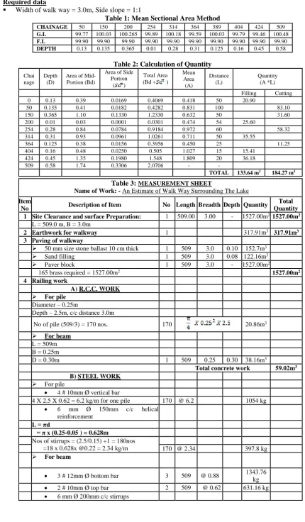
Width of walk way = 3.0m, Side slope = 1:1
Table 1: Mean Sectional Area Method
Table 2: Calculation of Quantity
Chai nage
Depth (D)
Area of Mid-Portion (Bd)
Area of Side Portion
( )
Total Area (Bd + )
Mean Area (A) Distance (L) Quantity (A *L)
Filling Cutting 0 0.13 0.39 0.0169 0.4069 0.418 50 20.90
50 0.135 0.41 0.0182 0.4282 0.831 100 83.10 150 0.365 1.10 0.1330 1.2330 0.632 50 31.60 200 0.01 0.03 0.0001 0.0301 0.474 54 25.60
254 0.28 0.84 0.0784 0.9184 0.972 60 58.32 314 0.31 0.93 0.0961 1.0261 0.711 50 35.55
364 0.125 0.38 0.0156 0.3956 0.450 25 11.25 404 0.16 0.48 0.0250 0.505 1.027 15 15.41
424 0.45 1.35 0.1980 1.548 1.809 20 36.18 509 0.58 1.74 0.3306 2.0706 - -
TOTAL 133.64 m3 184.27 m3
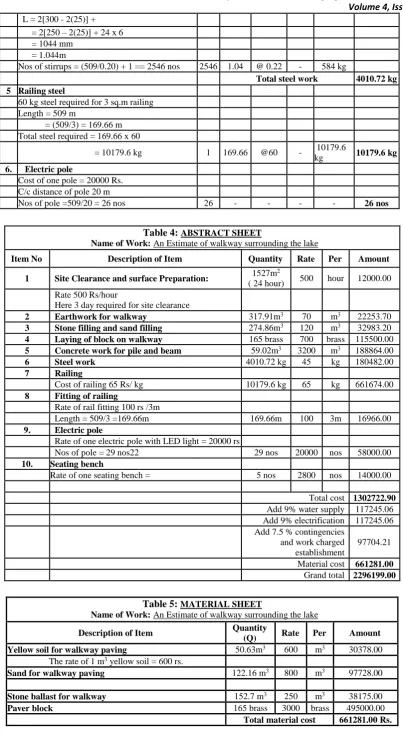
Table 3: MEASUREMENT SHEET
Name of Work: - An Estimate of Walk Way Surrounding The Lake
Item
No Description of Item No Length Breadth Depth Quantity
Total Quantity
1 Site Clearance and surface Preparation: 1 509.00 3.00 - 1527.00m21527.00m2
L = 509.0 m, B = 3.0m
2 Earthwork for walkway 1 317.91m3 317.91m3
3 Paving of walkway
50 mm size stone ballast 10 cm thick 1 509 3.0 0.10 152.7m3
Sand filling 1 509 3.0 0.08 122.16m3
Paver block 1 509 3.0 - 1527.00m2
165 brass required = 1527.00m2 1527.00m2
4 Railing work
A) R.C.C. WORK
For pile
Diameter – 0.25m
Depth – 2.5m, c/c distance 3.0m
No of pile (509/3) = 170 nos. 170 20.86m3
For beam
L = 509m B = 0.25m
D = 0.30m 1 509 0.25 0.30 38.16m3
Total concrete work 59.02m3
B) STEEL WORK
For pile
4 # 10mm Ø vertical bar
4 X 2.5 X 0.62 = 6.2 kg/m for one pile 170 @ 6.2 1054 kg
6 mm Ø 150mm c/c helical
reinforcement
L = πd
= π x (0.25-0.05 ) = 0.628m
Nos of stirrups = (2.5/0.15) +1 = 180nos
=18 x 0.628x @0.22 = 2.34 kg/m 170 @ 2.34 397.8 kg
For beam
3 # 12mm Ø bottom bar 3 509 @ 0.88 1343.76
kg
2 # 10mm Ø top bar 2 509 @ 0.62 631.16 kg
6 mm Ø 200mm c/c stirrups
10
L = 2[300 - 2(25)] + = 2[250 – 2(25)] + 24 x 6 = 1044 mm
= 1.044m
Nos of stirrups = (509/0.20) + 1 == 2546 nos 2546 1.04 @ 0.22 - 584 kg
Total steel work 4010.72 kg
5 Railing steel
60 kg steel required for 3 sq.m railing Length = 509 m
= (509/3) = 169.66 m Total steel required = 169.66 x 60
= 10179.6 kg 1 169.66 @60 - 10179.6
kg 10179.6 kg
6. Electric pole
Cost of one pole = 20000 Rs. C/c distance of pole 20 m
Nos of pole =509/20 = 26 nos 26 - - - - 26 nos
Table 4: ABSTRACT SHEET
Name of Work: An Estimate of walkway surrounding the lake
Item No Description of Item Quantity Rate Per Amount
1 Site Clearance and surface Preparation: 1527m
2
( 24 hour) 500 hour 12000.00
Rate 500 Rs/hour
Here 3 day required for site clearance
2 Earthwork for walkway 317.91m3 70 m3 22253.70
3 Stone filling and sand filling 274.86m3 120 m3 32983.20
4 Laying of block on walkway 165 brass 700 brass 115500.00
5 Concrete work for pile and beam 59.02m3 3200 m3 188864.00
6 Steel work 4010.72 kg 45 kg 180482.00
7 Railing
Cost of railing 65 Rs/ kg 10179.6 kg 65 kg 661674.00
8 Fitting of railing
Rate of rail fitting 100 rs /3m
Length = 509/3 =169.66m 169.66m 100 3m 16966.00
9. Electric pole
Rate of one electric pole with LED light = 20000 rs
Nos of pole = 29 nos22 29 nos 20000 nos 58000.00
10. Seating bench
Rate of one seating bench = 5 nos 2800 nos 14000.00
Total cost 1302722.90
Add 9% water supply 117245.06
Add 9% electrification 117245.06
Add 7.5 % contingencies and work charged establishment
97704.21
Material cost 661281.00
Grand total 2296199.00
Table 5: MATERIAL SHEET
Name of Work: An Estimate of walkway surrounding the lake
Description of Item Quantity
(Q) Rate Per Amount
Yellow soil for walkway paving 50.63m3 600 m3 30378.00
The rate of 1 m3 yellow soil = 600 rs.
Sand for walkway paving 122.16 m3 800 m3 97728.00
Stone ballast for walkway 152.7 m3 250 m3 38175.00
Paver block 165 brass 3000 brass 495000.00
11 B. Design Drawing:
The Drawing which is (Fig:3) made after a conducted tachometric survey of the lake for find rigid boundary line and it acts as main periphery line of a lake for no become any danger co-incidence in the future.
Figure 3: Rigid Line [Source: AutoCAD Drawing]
12 XI. CONCLUSION
Through Techno-Economic Survey of a village, various statistical data and present status of a village by visual inspection. And after making the extensive exercise of the data analysis, it is observed that the village has the basic and some fine facility available but there must be an enormous village needs to an enormous improvement in the solid waste management system. The door to door collection solid waste should be regulated by gram panchayat. The Villagers must be made aware about the ill-effects of throwing waste in the open, Also the planning and execution of beatification of lake should be done sufficiently effectively so as to improve the asthenic appeal of the village. Also, solar street lights are necessity spot should be provided with other improvement and necessity facility.
X. SUGGESTIONS
With proper efficient amenities and facilities, a village can provide a better place for Living. A well-developed Lake can enhance the beauty of village as well as Future Town Planning Scheme.
The village should be facilitating with some basic primary facilities like water supply scheme, efficient drainage, proper solid waste management, etc. so, their migration to nearby town can be avoided.
ACKNOWLEDGMENT
The success of any work depends upon the dedication, sincerity, hard work and knowledge. It also requires some ingredients such as motivation, encouragement, guidance and time.
We are very grateful to Mr Eidrish Patel Sarpanch of the village for providing us various smart village reports files and statically data of village which are more important for us without which the work would be abortive. We warmly acknowledge and express our special thanks for their efforts and invaluable contribution towards our project. We would like to express our deep sense of gratitude and heartfelt thanks to Mr N.P. Soni (Head of Department of
Civil Engineering Department, SVMIT Bharuch) for providing the constant motivation, inspiration, valuable technical guidance, and allowing us to do our project work on "Technical and Evaluation of rural infrastructure schemes".
We would like to thank all the faculty members of Department of Civil Engineering of Shri S'ad Vidya Mandal Institute of Technology (SVMIT) college.
Last but not least, we are grateful to our family and friends to provide us with their constant support and guidance financially as well as mentally to finish and submit our project work successfully.
REFERENCES
[1] The problem of solid waste management and people awareness on appropriate solid waste disposal in Bahir Dar City: Amhara region, Ethiopia Koyachew Enkuahone Kassie (ISABB) Received 27 February 2016; Accepted 16 April 2016.
[2] Bharuch District Panchayat Office, Gujarat Government. (bharuchdp.gujarat.gov.in/bharuch/english/yojnao/index) [3] General Development and Control Regulations Vol.III (GDCR) published by BAUDA (Bharuch & Ankleshwar
Urban Development Authority).
[4] Advanced Surveying Book, Author R.B. Khasiya.
[5] The Indian smart village, Foundation for growing India, by - Dr Pritesh Y Shukla, ISSN: 2394-5869, IJAR 2016; 2(3): 72-74.
[6] Technological Options for Solid and Liquid Waste Management in Rural Areas Ministry of Drinking Water and Sanitation Swachh Bharat Mission (Gramin) Government of India.
[7] The Indian smart village: Foundation for growing India Dr Pritesh Y Shukla, International Journal of Applied Research 2016; 2(3): 72-74.
[8] Modernization of Villages Through Vishvakarma Yojana: A Case of Pipodara Village, Surat, e-ISSN: 2455-5703. [9] Gandhiji on VILLAGES Selected and Compiled with an Introduction by, published with the financial assistance
received from the Department of Culture, Government of India. Published with the permission of The Navajivan Trust, Ahmedabad - 380 014.
![Figure 1: Map of Village [Source: Google Map]](https://thumb-us.123doks.com/thumbv2/123dok_us/8876161.1816995/2.595.121.440.122.316/figure-map-village-source-google-map.webp)
![Figure 2: Lake [Source: Paguthan Village]](https://thumb-us.123doks.com/thumbv2/123dok_us/8876161.1816995/3.595.283.551.459.636/figure-lake-source-paguthan-village.webp)
![Figure 3: Rigid Line [Source: AutoCAD Drawing]](https://thumb-us.123doks.com/thumbv2/123dok_us/8876161.1816995/6.595.129.463.447.755/figure-rigid-line-source-autocad-drawing.webp)
