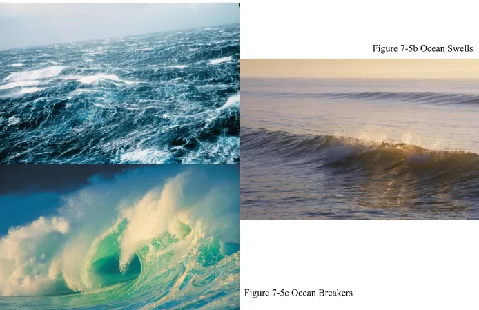
Types of Waves
Figure 7-5a Chaotic Waves
Figure 7-5b Ocean Swells
Waves and their Properties
•Parts of a wave are: –wave crest –wave trough –wave height (H) –wave amplitude –wave length (L) –wave period (T)
<-- Wave Types
<-- Disturbing Force
<-- Wave Period
• Wave period provides a basis for classifying waves
Wave classification
Note - the wave period → time it takes for one wavelength
to pass by) is unchanging for any given wave train.
Most of the waves present on the ocean’s surface
are wind-generated waves
• Size and type of wind-generated waves are controlled
by:
– wind velocity (strength of the wind) – wind duration
– Fetch (distance over which the wind blows) – original state of the sea surface
• As wind velocity increases:
• Wavelength • period
• height
• A
fully developed
sea means the
wind-generated waves are as large as they
can be under current wind velocity and
fetch.
• Significant wave height is the average of the
highest 1/3 of the waves present.
– It is a good indicator of potential for:
• Fetch is the area of contact between the wind and the water.
– It is where wind-generated waves begin.
• Seas is the term applied to the sea state of the fetch when
there is a chaotic jumble of new waves.
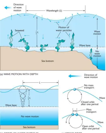
• Water molecules move in an
orbital
motion as the
wave passes.
• Diameter of orbit:
– increases with increasing wave size
– decreases with depth below the water surface as
energy is reduced
The Motion of Water Particles Beneath Waves
Figure 7-3a Wave Motion with Depth
Figure 7-3b Orbits of Water Particles
Figure 7-3c Stokes Drift
Stokes Drift - refers to the fact that water
•
Wave base
is the depth to which a surface wave
can move water.
•
Deep-Water Wave
: If the water is
deeper
than
wave base:
– orbits are circular
– there is no interaction between the bottom and the wave
•
Shallow Water Wave
: If the water is
shallower
than wave base:
– orbits are elliptical
The Distortion of Water-Particle Orbits in
Shallow Water
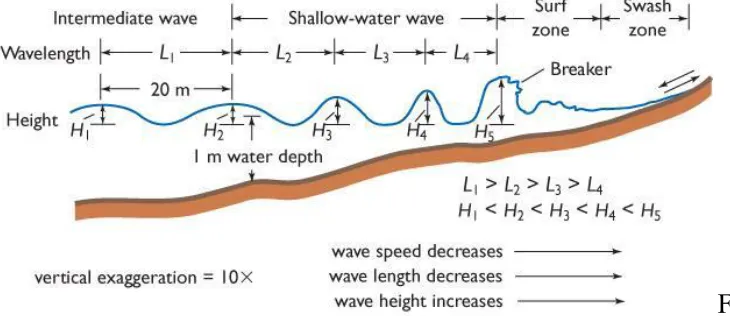
Example: Wavelength = 20 meters
Deep waterwave
when depth > 10 m
Transititional Wave
When depth < ½ and > 1/20 wavelength
Shallow-water wave
• The shallower the water, the greater the
interaction between the wave and the
bottom.
– This alters the wave properties, eventually
causing the wave to collapse.
• When depth decreases:
– Wave speed decreases
– Wavelength decreases
– Wave height increases
• There are three types of waves defined by water
depth:
– Deep-water wave (water deeper than 1/2 wavelength)
• Orbits are circular; no interaction with bottom
– Intermediate-water wave (water depth between 1/20 and 1/2 wavelength = Transitional Wave)
• Some orbit flattening
– Shallow-water wave (water depth less than 1/20 wavelength)
• Because celerity (velocity of wave train)
increases as wavelength increases,
long
waves travel faster than short waves
.
• Wavespeed (Celerity)
– Of deep water wave: C = 1.25 (√wavelength)
OR C = 1.56 (period)
– Of Shallow-water wave: C = 3.1 (√depth)
• In shallow water:
– Troughs become flattened and the wave profile
becomes extremely asymmetrical.
– Period remains unchanged.
• Period is a fundamental property of an ocean wave
- set by the disturbing force.
Wave steepness is a ratio of
wave height
divided by
wavelength
(H/L)
• In shallow water:
– wave height increases
– wave length decreases
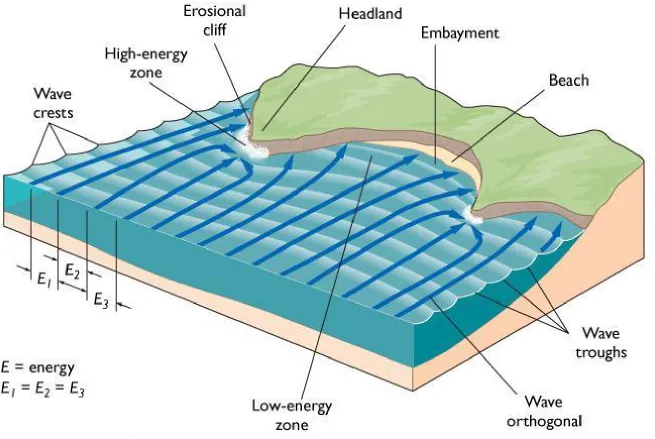
Wave Transformation
Figure 7-7a Deep-Water Wave Transformations
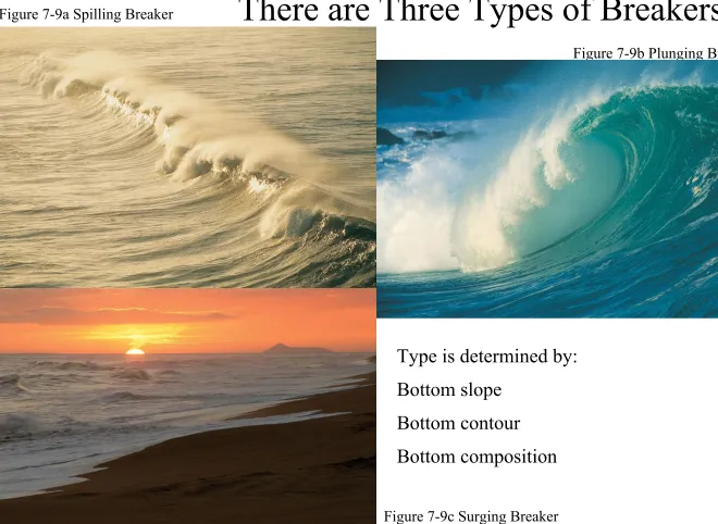
There are Three Types of Breakers
Figure 7-9a Spilling Breaker
Figure 7-9b Plunging Breaker
Figure 7-9c Surging Breaker
Type is determined by:
Bottom slope
Bottom contour
Beaches and Coastlines
• This portion of the waves presentation has
been hijacked by the subfeature on beaches
and coastlines!
• People like to alter the shore…with their
revetments, groins, jetties, breakwaters…
etc.
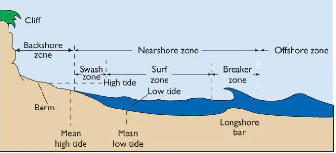
The beach is the part of the land that touches the sea.
• It can be divided into the:
– Offshore – Nearshore
• breaker zone
• surf zone • swash zone
– Backshore
• Position of the divisions of the beach varies with the tides.
The Coastal Zone
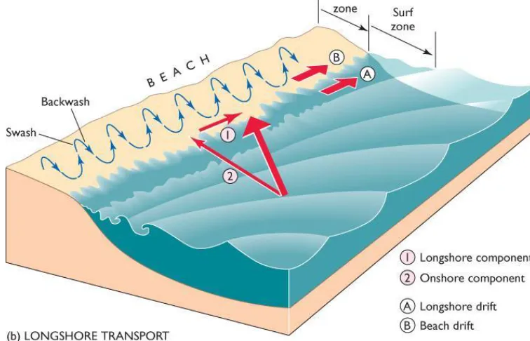
Longshore currents
transport sand grains (and
swimmers) parallel to the
shore; some energy from
wave propels water along
shore in narrow current.
Figure 11-1b Longshore Transport
Figure 11-1c Longshore Current
Longshore Drift is the
• Angle of wave approach is the acute angle (less than 90o) between the wave crest and the beach.
• The direction of longshore current varies with the direction of wave approach.
• Longshore currents can also be generated by wave set-up.
• Where two opposing longshore currents collide, they form a swift, narrow, seaward rip current.
Coastlines are desirable areas for human habitation
• Human activity conflicts with the dynamic
state of coastal systems.
• Humans try to stabilize the coastline in two
ways:
• Preventing of sand drift involves jetties and
groins.
• Redirecting wave energy involves breakwaters and
seawalls.
• Beach nourishment with sand is expensive and
temporary.
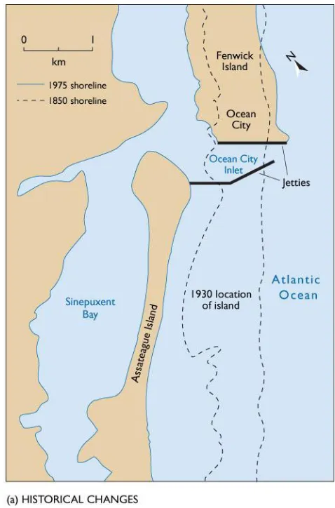
Coastal Engineering Structures
• In 1934-35, jetties were built to
stabilize the inlet between Ocean
City, on Fenwick Island, and
Assateague Island.
• Beaches along Ocean City
accreted as sand was trapped on
the updrift side of the northern
jetty.
• Assateague Island, denied its
sand supply from longshore drift
from the north, rapidly eroded
(about 40 feet/year).
The Ocean Sciences: Ocean City and Assateague Island, Maryland
Summary of previous concepts…
(quick review before moving on…)
Summary of previous concepts…
Wave types and wave properties
Disturbing/restoring forces
Movement of water in a water wave
Speed of wave
Longshore current and drift
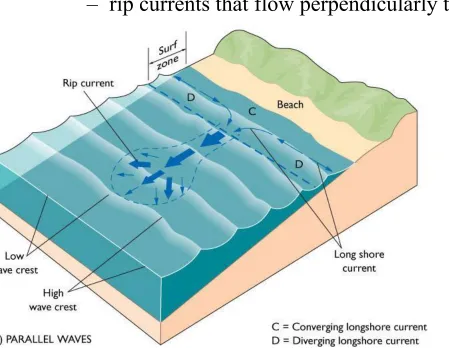
• Waves generate:
– longshore currents that flow parallel to the beach – rip currents that flow perpendicularly to the beach
Figure 11-1d Parallel Waves
Rip currents form when a group of waves piles excess water on landward side of surf zone
Standing waves
or
seiches
consist of a water
surface “seesawing” back and forth
• A
node
is an imaginary line across the
surface that experiences no change in
elevation as the standing wave
oscillates
.
– It is the line about which the surface oscillates.
•
Antinodes
are where there is maximum
displacement of the surface as it oscillates.
Natural Period of Standing Waves
Figure 7-11 Natural Period of Standing Waves
• Geometry of the basin controls the period of
the standing wave.
– A basin can be closed or open.
• Standing waves can be generated by storm
surges.
•
Resonance
amplifies the displacement at
the nodes.
– It occurs when the period of the basin is similar
to the period of the force producing the
Internal waves form within the water column along the
pycnocline
• There is small density difference between the
water masses above and below the pycnocline.
– Therefore, properties of internal waves are different from surface waves.
• They travel more slowly • They can be much larger
• Internal waves display all the properties of surface
progressive waves including:
– Reflection – Refraction – Interference – breaking, etc.
• Any disturbance to the pycnocline can
generate internal waves, including:
– flow of water related to the tides
– flow of water masses past each other
– storms
– submarine landslides
Tsunamis
• Tsunamis were previously called tidal waves, but are unrelated to tides.
• Tsunamis consist of a series of long-period waves characterized by:
– very long wavelength (up to 100 km)
– high speed (up to 760 km/hr) in the deep ocean
• Because of their large wavelength, tsunamis are
shallow-water to intermediate-water waves as they travel across the ocean basin.
Tsunamis originate from earthquakes,
volcanic explosions, or submarine landslides.
Figure 7-13a Generation of a Tsunami
On December 26, 2004, an earthquake with a magnitude of over 9.0 on the Richter scale
triggered a megatsunami that affected
•
Storm surge
is the rise in sea level resulting
from:
– low atmospheric pressure
– accumulation of water driven shoreward by
storm winds
• Water is deeper at the shore area, allowing
waves to progress farther inland.