Site Plan Control By-law
C.P.-1455-541 - Consolidated February 9, 2015
As Amended by
By-law No. Date Passed at Council
C.P.-1455(a)-590 July 24, 2006
C.P.-1455(b)-344 October 21, 2008
C.P.-1455(c)-56 February 2, 2009
C.P.-1455(d)-299 November 15, 2010
C.P.-1455(e)-16 December 20, 2010
C.P.-1455(f)-78 February 28, 2011
C.P.-1455(g)-237 August 30, 2011
C.P.-1455(h)-278 September 19, 2011
C.P.-1455(i)-153 May 1, 2012
C.P.-1455(j)-166 May 14, 2013
C.P.-1455(j)-303 September 2, 2014
C.P.-1455(k)-356 October 14, 2014
C.P.-1455(l)-382 November 25, 2014
C.P.-1455(m)-58 February 9, 2015
This by-law is printed under and by authority
of the Council of the City of London, Ontario, Canada
Disclaimer:
The following consolidation is an electronic reproduction made available for information only. It is not an official version of the By-law. The format may be different, and plans, pictures, other graphics or text may be missing or altered. The City of London does not warrant the accuracy of this electronic version. This consolidation cannot be distributed or used for commercial purposes. It may be used for other purposes only if you repeat this disclaimer and the notice of copyright.
Copies of Official versions of all By-laws can be obtained from the City Clerk’s Department by calling 519-661-4505.
For by-law related Inquiries please contact 519-930-3510.
For by-law related Complaints please contact Municipal Law Enforcement Officers at 519-661-4660 or
Bill No. 299 2006
By-law No. C.P.-1455-541
A by-law to designate a site plan control area and to delegate Council's power under Section 41 of the Planning Act, R.S.O. 1990, c.P.13.
WHEREAS Section 41 of the Planning Act, R.S.O. 1990, c.P.13 provides in part that, where in an official plan an area is shown or described as a proposed site plan control area, the council of the local municipality in which the proposed area is situate may, by by-law, designate the whole or any part of such area as a site plan control area and may delegate to either a committee of the council or to an appointed officer of the municipality any of the council's power or authority under that section;
AND WHEREAS Clause 5(2)(b) of the Building Code Act authorizes the council of a municipality to pass by-laws requiring applications for building construction permits to be accompanied by such plans, specifications, documents and other information as is prescribed;
AND WHEREAS in the Official Plan for the City of London Planning Area the whole of the City of London is shown or described as a proposed site plan control area and the Council of The Corporation of the City of London considers if appropriate to designate the whole of the City of London as a site plan control area, to delegate its powers or authority under Section 41 of the Planning Act, R.S.O. 1990, c.P.13, to certain appointed officials of the Corporation, and to require applications for building construction permits to be accompanied by plans and drawings referred to in Subsection 41(4) and by one or more agreements with the Corporation that deal with or ensure the provision and maintenance of any of the facilities, works or matters to be provided in conjunction with all buildings and structures to be erected and any of the facilities, works or matters mentioned in Subsection 41(7) of that Act.
THEREFORE the Municipal Council of The Corporation of the City of London enacts as follows:
SITE PLAN CONTROL AREA BY-LAW INTERPRETATION
Definitions
1. In this by-law, unless a contrary intention appears,
(a) "Act" means the Planning Act, R.S.O. 1990, c.P. 13;
(b) "Corporation" means The Corporation of the City of London; (c) "Council" means the municipal council of the Corporation;
(d) "delegated official" means any of the appointed officers of the Corporation identified in Schedule 3 to this by-law either by name or position occupied;
(e) "development" means
(i) the construction, erection or placing of one or more buildings or structures on land; or
(ii) the making of an addition or alternation to a building or structure that has the effect of substantially increasing the size or usability thereof; or
(iii) the laying out and establishment of a commercial parking lot or of sites for the location of three or more trailers or of sites for the
OFFICE CONSOLIDATION
location of three or more mobile homes; or
iv) sites for the construction, erection or location of three or more land lease community homes;
and includes redevelopment;
(f) “Development Agreement” means an agreement entered into between the Corporation and the Owner outlining the terms and conditions of the development and the approved plans and drawings as provided under Section 41(7)(c) of the Planning Act RSO 1990;
(g) "mobile home" means any dwelling that is designed to be made mobile, and constructed or manufactured to provide a permanent residence for one or more persons, but does not include a travel trailer or tent trailer or trailer otherwise designed;
(h) "Official Plan" means the Official Plan for the City of London Planning Area as amended from time to time;
(i) “Owner” means the person appearing as the registered Owner according to the records of the proper land registry office or a person in the actual occupation of land sold to the Director in accordance with the Veterans’ Land Act (Canada) shall also be deemed to be the Owner;
(j) "security policy" means the policy regarding subdivision security and development agreement security adopted by resolution of Council on November 2, 1981, as amended from time to time, or any successor of that policy;
(k) "Site Plan Design Manual" means Schedule 1 to this by-law; and
(l) "trailer" means any vehicle so constructed that it is suitable for being attached to a motor vehicle for the purpose of being drawn or propelled by the motor vehicle, and capable of being used for the living, sleeping or eating accommodation of persons, notwithstanding that such vehicle is jacked-up or that its running gear is removed.
Site Plan Design Manual
2. (1) The Site Plan Design Manual is attached as Schedule 1 and forms part of this by-law.
Metric
3. Wherever Metric measure is used in the Design Manual, the inclusion in parenthesis of Imperial measure is for convenience only and, in the event of any discrepancy between the Metric measure and the corresponding Imperial measure, the Metric measure applies.
DEVELOPMENT SUBJECT TO SITE PLAN APPROVAL Site Plan Control Area
4. The whole of the City of London as constituted from time to time is hereby designated as a site plan control area.
Exempt Classes of Development
5. The following classes of development may be undertaken without the approval of plans and drawings otherwise required under Subsection 41(4) or (5) of the Act, and this by-law does not apply to such classes:
(a) A building or structure which is constructed, erected or placed on a freehold lot for the purpose of a single detached dwelling unit or a semi-detached dwelling unit or a duplex dwelling, except a single sideyard dwelling unit and except where the approval of plans or drawings is required as a condition of provisional consent or a condition of a Minor Variance decision or otherwise required by the Official Plan.
(b) An addition or alteration to a building or structure mentioned in Clause (a) except a single side yard dwelling unit and except where the approval of plans or drawings is required as a condition of provisional consent or a condition of a Minor Variance decision or otherwise required by the Official Plan.
(c) Agricultural and farm related buildings, building additions, building alterations or structures that are utilized in farming operations but not including agricultural-commercial or industrial operations such as farm equipment sales and service, farm supply sales and agricultural storage, service or supply establishments. (d) Sand and gravel pits located in the City.
Provision and Maintenance of Facilities, etc.
6. As a condition to the approval of the plans and drawings referred to in subsection 41(4) of the Act, the Owner of the land shall hereby:
(a) provide at no expense to the Corporation the facilities, works or matters mentioned in clause 41(7)(a) of the Act approved in accordance with Section 41 of the Act and shown on the approved plans and drawings and in the development agreement; and
(b) maintain at the sole risk and expense of the Owner the facilities or works mentioned in paragraphs 2, 3, 4, 5, 6, 7, 8 and 9 of clause 41(7)(a) of the Act and shown on the approved plans and drawings and in the development agreement, approved in accordance with Section 41 of the Act, including the removal of snow from access ramps and driveways, parking and loading areas and walkways.
APPROVAL OF PLANS AND DRAWINGS Application for Approval
7. Every site plan application shall be accompanied by the following plans, specifications, documents and information:
(a) the plans referred to in Paragraph 1 of Subsection 41(4) of the Act, showing all facilities and works to be provided in conjunction with the building or structure and all the facilities, works and matters referred to in Clause 41(7)(a) of the Act in accordance with Schedule 1, Site Plan Design Manual submission requirements; (b) the drawings referred to in Paragraph 2 of Subsection 41(4) of the Act in
accordance with Schedule 1, Site Plan Design Manual submission requirements; (c) where required under clause 9(b) of this by-law one or more agreements with the
Corporation in the form in Schedule 2 to this by-law dealing with the provision and maintenance of the facilities and works to be provided in conjunction with the building or structure and the facilities, works and matters mentioned in Subsection 41(7) of the Act in accordance with the plans and drawings approved pursuant to the Act and this by-law and in accordance with Schedule 1, Site Plan Design Manual submission requirements;
(d) where required under an agreement referred to in clause (c) cash or an irrevocable letter of credit in favour of the Corporation in accordance with schedule 1 council's security policy to protect the Corporation in respect of its liability for holdback and costs under Subsection 17(4) of the Construction Lien Act, 1990 and to assure satisfactory provision and maintenance of the facilities and works to be provided in conjunction with the building or structure and the facilities, works and matters mentioned in Subsection 41(7) of the Act in accordance with the plans and drawings approved pursuant to the Act and this by-law and in accordance with Schedule 1, Site Plan Design Manual submission requirements; and
(e) all reports and studies required on the record of consultation. Delegation to Appointed Officers
8. (1) Subject to Section 9 schedule 3 of this by-law, all of the Council's powers or authority under Section 41 of the Act, except the authority to define any class or classes of development as mentioned in Clause 41(13)(a) of the Act, are hereby delegated to and may be exercised by one or more of the appointed officers of the Corporation identified in Schedule 3 to this by-law either by name or position occupied.
(2) The Council hereby appoints each appointed officer to be appointed officersto sign and deliver, together with another one of the appointed officers, for and in the name and behalf of the Corporation agreements in the form in Schedule 2 to this by-law, and such agreements shall be binding upon the Corporation without any further authorization or formality.
Exercise of Power
9. The exercise of the powers, authority or appointment delegated or made under Section 8 of this by-law is subject to the following:
(a) An appointed officer shall approve the plans and drawings referred to in Subsection (41)(4) of the Act except where,
(i) the proposed facilities, works or matters shown on the plans and drawings are not consistent with the Provincial Policy Statement, are not consistent with the policies of the Official Plan and other Council approved policy, do not comply with the zoning by-law and any other applicable by-law.
(ii) where submission requirements of the application under Section 7 of this by-law are incomplete.
(b) As a condition to the approval of plans and drawings referred to in Subsection 41(4) of the Act, the appointed officer may require that the Owner of the land enter into one or more agreements referred to in Paragraph (7)(c) of this by-law. (c) The powers or authority under Clauses 41(7)(b) and (c) of the Act with respect to
any of the facilities, works or matters mentioned in Paragraphs 1, 2, 3, 7, 8 and 9 of Clause 41(7)(a) of the Act shall be exercised by an appointed officer on the advice of the City Engineer or his delegate.
(d) The provisions of the Site Plan Design Manual shall be applied in each circumstance as it arises with such variations or modifications as the circumstances may require so long as each applicable provision is given effect according to its true intent and purpose.
(e) The form or wording of the agreement in Schedule 2 shall be used with such variations or modifications as circumstances may require so long as the substance is not changed or affected and any variance from Schedule 2, not being in manner or substance, does not affect the regularity of any agreement. In addition to this, other clauses may be added as required by the appointed officer.
(f) (i) At the time of considering a zoning or rezoning of a property or properties, the Built and Natural Environment Committee may as part of their recommendation to City Council require that a site plan public meeting be held to receive comments regarding the site plan, building elevations, landscape plan and any requirements of the development agreement by placing a holding provision with the proposed zone without further notice or by adding a direction for staff to hold a public meeting at Built and Natural Environment Committee and based on the one or more public meetings Council should advise the appointed officer of any items to consider in their reviews as raised by the public and/or as advised by Council; or
(ii) In some cases, Official Plan Policies may require a site plan public meeting. In these cases the appointed officers will request that the Built and Natural Environment Committee convene a public meeting on behalf of the appointed officers to obtain input from the public and receive advice from Council and subsequently report to the appointed officers the results of the public meeting and any comments of Council; or
(iii) When, in connection with a specific application, City Council passes a by-law to revoke the powers under Section 8 of this By-by-law, a public site plan meeting shall be convened by the Built and Natural Environment committee and the Owner shall be afforded an opportunity to be heard at a public meeting of the Built and Natural Environment Committee, for the purpose of considering the plans and drawings and requirements pertaining to the development. The Built and Natural Environment Committee shall provide a recommendation to Council
concerning the approval of the plans and drawings pertaining to the development and any requirements under Subsection 41(7) of the Act, including the provision of any agreement required; or
(iv) In any case where development has been the subject of a public site plan meeting and that development does not proceed, a further public site plan meeting will be required when a new site plan application is made for the same lands. In cases where an application is made to make minor amendments in keeping the general intent of the plans approved by Council, the appointed officers may approve these changes and may add any additional clauses to the agreement without the need for a further public site plan meeting except as otherwise directed by Council.
Executive Acts Authorized
10. The Mayor and City Clerk are hereby authorized to execute on behalf and under the seal of the Corporation any document necessary to give further effect to the provisions of this by-law, when the appointed officers’ authority has been revoked.
ENFORCEMENT Conflict of Laws
11. In the event of conflict between the provisions of the Site Plan Design Manual and any applicable zoning by-law or federal or provincial statute or regulation, the provisions of the zoning by-law, statue or regulation shall apply.
Development Without Approved Plans
12. Every person who, without having plans or drawings approved in accordance with Section 41 of the Act, undertakes any development in the site plan control area designated by this by-law is pursuant to Section 67 of the Act, guilty of contravening Section 41 of the Act.
Failure To Provide or Maintain Facilities, etc.
13. Every person who undertakes any development in the site plan control area designated by this by-law without providing or maintaining any of the facilities, works or matters that are mentioned in Clause 41(7)(a) of the Act and that are required by the Corporation under that clause as a condition to the approval of plans or drawings in accordance with Section 41 is, pursuant to Section 67 of the Act, guilty of contravening Section 41 of the Act.
Failure To Enter Into Agreement
14. Every person who undertakes any development in the site plan control area designated by this by-law without entering into one or more agreements with the Corporation that deal with or ensure the provision or maintenance of any of the facilities, works or matters and that the person is required by the Corporation to enter into under that subsection as a condition to the approval of plans and drawings in accordance with Section 41 is, pursuant to Section 67 of the Act, guilty of contravening Section 41 of the Act.
Penalty Upon Conviction
15. Every person who is convicted of an offence under Section 41 of the Act is liable to fine or penalty prescribed by Section 67 of the Act.
Thomas C. Gosnell Deputy Mayor
Kevin Bain City Clerk
First Reading – June 26, 2006 Second Reading – June 26, 2006 Third Reading - June 26, 2006
Schedule 1
to By-law No. C.P.-1455-541
Table of Contents 1.
Submission Requirements.
2. Location of Buildings and Facilities
3. External Facilities and Works in conjunction with the Site
4. Road Widening
5. Access to and from Site
6. Parking Facilities and Internal Driveway
7. Walkways and all other means of Pedestrian Access
8. Facilities for Lighting including Floodlighting
9. Landscaping and Buffering of the Site
10. Facilities and Enclosures for the Storage of Garbage and Recycling
11. Easements
12. Grading and disposal of Storm, Surface and Wastewater
13. Tree Preservation
14. Bicycle Facilities
15. Water Servicing
Schedule 2 – Development Agreement Clauses Schedule 3 – List of appointed Officers”
1. SUBMISSION REQUIREMENTS to By-law, CP-1455-541 Site Plan Design Manual a. Introduction
Site plan drawings accompanying an application for site plan approvalare required to demonstrate how a proposal meets the various aspects of the Official Plan Policies, the Zoning By-law and the City's Site Plan Control Area By-law.
All the information may be presented on one drawing provided the information is clearly legible and accurate. On more complex proposals it may be necessary to prepare separate drawings to illustrate each aspect more clearly, e.g. existing conditions, site plan, landscape plan site servicing plan, building elevations and a legal plan.
All projects require a site plan drawn to scale on a manageable sheet size. A plan of topographical survey of the job, if available, will assist in the assessment of the project. Building elevations are also required and in some cases, cross-section drawings and an Urban Design Brief are also required.
The following sections outline the submission requirements for each submission point in the Site Plan Approval process. Incomplete submissions will not be received for processing. Where possible all submissions should be made in hard copy and electronic (.pdf) formats.
1.2. Request for Consultation Package
The Request for Consultation summarizes the Applicant’s concept plan and assumptions for developing their site. Submission of a Site Plan Request for Consultation constitutes the Applicant’s formal request to initiate Mandatory Consultation as required under the City’s Planning Pre-consultation By-law, C.P. 1469-217. A Request for consultation Package includes:
(a) Supporting Information Cover Document including the completion of the Site Plan Request for Consultation form
1. Description of the proposed site;
2. Written report of the context within the existing neighbourhood and the current Official Plan policy, including a map to contextualize the site/layout with the neighbourhood;
3. Intention and objectives of the proposed site plan; and 4. Servicing assumptions for the site.
(b) Concept Site Plan Drawings: All packages require a dimensioned plan illustrating the proposed concept for development of the site and showing key existing and proposed site features on the face of the plan such as location of buildings, significant vegetation, access, etc.:
• Dimensioned plan illustrating the proposed site. • Location of exiting and proposed buildings on the site. • Significant trees and natural vegetation.
• Hard and soft Landscaping
• Pedestrian and vehicular access to/from the site • Location and nature of vehicle/bicycle parking • Loading/service/garbage areas
• Sign location(s)
• Principal pedestrian entrance, barrier free entrance and fire fighters’ entrance
• Fencing (location & type)
• Easements, comments on the property (c) Concept Elevations:
The request package shall include concept elevations for each view of the proposed development (Depending upon the type and scale of the proposed development) concept elevations may take the form of either drafted plans, doctored photos or illustrated examples. Detailed elevations are not required at this stage but the provided concepts should
adequately convey the proposed built form and appearance of the development and include items such as:
• Facades labelled according to the direction they face • Indicate facade materials to be used
• Identify major pedestrian entrances
• Indicate Base, Middle, Cap of the structure(s) • Roof type
• Sign location(s)
• Vision (transparent) glass location(s)
• Existing condition plan as per Section 1.4 of Schedule “I” • Context with nearby buildings
REQUIREMENTS PLANS AT THE APPLICATION STAGE The following plans are required for Site Plan Approval
1.3. Legal Plan Requirements
The Legal plan (if required) should show the following:
(a) plans in blackline only, 56 cm x 82 cm maximum (22" x 32"), of development site, including a calculation of its area, certified by an Ontario Land Surveyor;
(b) title, location of project, date, of the survey;
(c) north point and scale (graphic bar scale as well as written ratio scale); and
(d) bearings and distance of all property lines, and dimensions and location of all existing buildings and structures.
1.4. Existing Conditions Plan Requirements The existing conditions plan should show the following:
(a) dimensions and locations of all existing buildings or structures, fences, access driveways, fire hydrants and utility poles;
(b) existing site constraints, such as adjacent streets (showing curbs, gutters, ditches, etc.), sidewalks, rights of way and easements;
(c) the location, elevation, size and species of:
(i) trees exceeding 100 mm (4 inches) diameter at breast height; (ii) trees and shrubs exceeding 1.5 metres (5 feet) in height located:
- on a property line of the proposed development
- on the proposed development and within 6 metres (19.6 feet) of a property line including a property line common to a public street
- on lands adjacent to the proposed development and within 3.0 metres (10 feet) of the common property line;
(iii) trees and shrubs on the boulevard of the public street along the streetline(s) of the proposed development; and
(iv) wetlands, ESA(s), woodlands and Areas of Natural and Scientific Interest
(d) existing location and/or distance of the nearest transit stop from the limits of the property;
(e) existing location and/or distance of the nearest transit stop from the limits of the property;
(f) existing uses on abutting properties; (g) existing contours; existing servicing;
(h) existing easements or restrictive covenants. 1.5. Site Plan Requirements (see Figure 9.2 for Example) The site plan requirements are as follows:
(a) plans submitted to be in blackline only, no greater than 56 cm x 82 cm (22" x 32") (for reduction purposes) folded to 22 cm x 28 cm or 36 cm (8 1/2" x 11" or 14");
(b) key map - scale 1:2,000 outline of the development site with sufficient amount of surrounding area to indicate its general location, with major adjacent features, such as parks, bus routes, etc. (base map is available from the City);
(c) title, location (plan and lot number) and date;
(d) north point and metric scale [preferably 1:500 (1" = 40') or 1:250 (1" = 20') graphic bar scale, as well as a written ratio scale];
(e) centre line and curb line of adjacent streets, sidewalks and existing street line; required dedication for street widening purposes and future road widening in accordance with adopted Council standards in the Official Plan and the Zoning By-law (all dimensions should be included on the drawing);
(f) if the site is adjacent to a river or large watercourse, the site plan drawing should show the location of the surface water at normal flows, the floodplain boundary, if it has been established by the Upper Thames River Conservation Authority, contours of the valley and the banks at not more than 1.5 m (5 feet) intervals and the dedication line;
(g) clear indication of subject property’s boundary being the same as the legal plan(dimensions and area calculations);
(h) approximate location and height of buildings on adjacent sites; (i) adjacent property owned or controlled by the applicant;
(j) locations, height and dimensions [distances between buildings and yard dimensions (front yard, side yard, rear yard)] of all buildings and other structures proposed on the site;
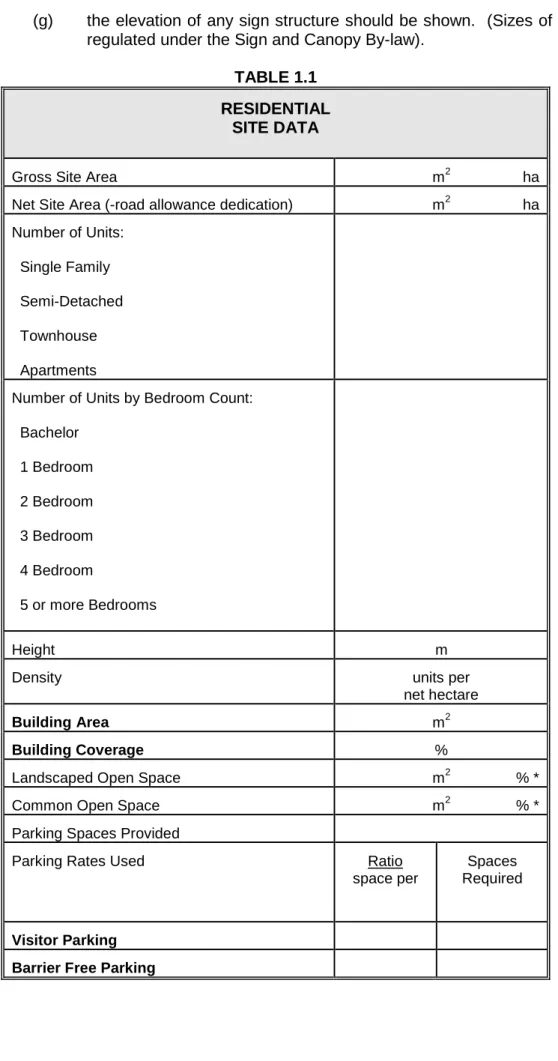
(k) a "site data" schedule as illustrated in Table 1.1 for residential uses, industrial, institutional and Table 1.2 for commercial uses;
(l) location and height of external lighting fixtures;
(m) garbage storage (type and location) and collection areas;
(n) loading and on site vehicular circulation areas, indicated widths and proposed direction of traffic flows as well as proposed ramps or access driveways;
(o) proposed parking areas or structures; number of spaces, dimensions of parking spaces, aisles and driveways, location of pedestrian and vehicular building entrances, and area to be devoted to each proposed use;
(p) proposed snow storage areas (q) landscaped areas;
(r) where there is a major change in existing topography, existing and proposed grades at key points, such as building corners, tops and bottoms of proposed slopes, walls, curbs and steps;
(s) location and height of free-standing signs;
(t) location of walkways and bicycle ways including surface treatment; and (u) identification of transit routes abutting or adjacent to a proposed
development site, and the location and/or distance from the limits of the site to the nearest transit stops.
1.6. Landscape Plan Requirements
1.6.1 Landscape Planting Plan (See Figure 9.1 for Example)
The base plan for the landscape plan should be the same as the site plan. The landscape plans should be in blackline only, 56 cm x 82 cm (22" x 32"), and should include:
(a) location by symbol of all existing trees (to be preserved) and proposed trees and shrubs (the symbol should reflect the branch spread or canopy of existing trees and shrubs, and the proposed trees and shrubs at maturity):
(b) a list of all species, including common name, botanical name, quantity, size and condition at planting (see Table 9.4);
(c) planting specifications including sodding (see Table 9.6);
(d) cross-section to show detailed tree and potted shrub planting methods (see Figure 9.3); and
(e) the landscape plan should include the professional endorsement (stamp) of a landscape architect or equivalent where warranted.
1.6.2 Tree Preservation Plan
Trees and shrubs proposed for preservation and preservation measures can be incorporated on the Landscape Planting Plan or shown on a separate Tree Preservation Plan. Separate Tree Preservation Plans should:
(a) be at the same scale as other site plans and preferably superimposed upon the Site Servicing Plan;
(b) accurate location of existing vegetation; (c) existing and proposed grade elevations;
(d) building(s), site facilities including parking areas, driveways, service areas, pedestrian walkways, and underground and overhead services; and
(e) limits of construction/ground disturbance. 1.7. Site Servicing Plan Requirements
The site servicing plan should be prepared by a registered Professional Engineer in Ontario and the plans shall be stamped and signed. This should include:
1.7.1. Sanitary Sewer Systems
(a) drainage piping - location, from building to private drain connections, size and grade;
(b) private drain connections - existing and new, location, size and grade; (c) control manholes (if required, see Section 12.6), to be located at the
street line on private property;
(d) all manholes to show invert and finish grade elevations; and
(e) The design of “private” sewer and water are to conform to the requirements set out in the Ontario Building Code. In some cases, these
systems may require a Certificate of Approval by the Ministry of Environment.
1.7.2 Storm Drainage Systems and Grading Plans
(a) catch basins - locations, proposed elevations for grates, and inverts; (b) all manholes to show invert and finish grade elevations;
(c) drainage piping - location, size, grade (slope);
(d) private drain connections - existing and new, location, size and grade; (e) drainage swales (landscaped areas) - elevations along swale, cross
sections % grade (slope);
(f) overland flow - show flow arrows to permit ready identification of overland flow direction, show existing and proposed elevations along property lines, and key points on site and abutting properties;
(g) flows from adjacent properties - in the event that adjacent private properties drain onto the site being developed, the storm drainage system is to be designed to prevent storm water from backing up and creating a flooding or ponding condition on the adjacent property;
(h) weeping tiles - where weeping tiles are to be installed show how the flows will be handled to comply with Section 12.1;
(i) dry-well systems, infiltration systems and storm retention systems - the site services plan is to display such relevant detail contained in the consulting engineer's design as will be necessary to insure that all design features are implemented by the contractor (see Sections 12.3 and 12.4); and
(j) the site shall be designed to the standards and specifications of the City and any alternative designs, enhanced operational requirements shall be approved by the City Engineer.
1.7.3 Water Systems
a) show size and location of watermain, valves, fire hydrants, siamese connections, chambers, water meter location(s), etc.; b) existing services and service box chambers;
c) watermain and water service design to City of London specifications and Ministry of the Environment requirements;
d) Where the Ontario Building Code does not specify, the City of London’s specifications shall take precedence for all watermain and services;
e) All watermain and services above 100 mm diameter and larger shall be swabbed, chlorinated, and tested in accordance with applicable standards and requirements.
1.8. Building Elevations and Cross-Section Drawings Requirements(Fig. 1.1)
The following must be submitted:
(a) the drawings submitted to be in blackline, no greater than 56 cm x 82 cm (22" x 32") - it is preferred that this drawing be included on the site plan drawing;
(b) scale 1:200 (1" = 16') or 1:100 (1" = 10') as appropriate;
(c) elevations of all facades of the buildings and front facade of any buildings on adjacent property;
(d) the elevations should show all windows, doors, other openings, and any mechanical equipment on the roof. The habitable and non-habitable room windows of dwelling units should be identified on the drawing. Signs and graphics should also be shown;
(e) Indicate the type, colour and texture of materials;
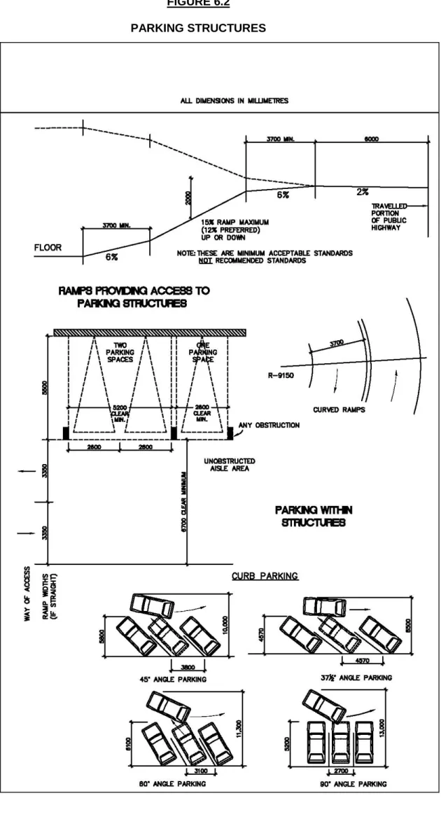
(f) a longitudinal cross-section view through the building to the street line, including all parking structures, should be shown - where parking structures are included, a cross-section should be taken along the driveway providing access to the street showing the slope of the ramps (see Figure 6.2 for standards); and
(g) the elevation of any sign structure should be shown. (Sizes of signs are regulated under the Sign and Canopy By-law).
TABLE 1.1 RESIDENTIAL
SITE DATA
Gross Site Area m2 ha
Net Site Area (-road allowance dedication) m2 ha Number of Units:
Single Family Semi-Detached Townhouse Apartments
Number of Units by Bedroom Count: Bachelor
1 Bedroom 2 Bedroom 3 Bedroom 4 Bedroom
5 or more Bedrooms
Height m
Density units per
net hectare
Building Area m2
Building Coverage %
Landscaped Open Space m2 % *
Common Open Space m2 % *
Parking Spaces Provided
Parking Rates Used Ratio
space per
Spaces Required
Visitor Parking Barrier Free Parking
TABLE 1.2
COMMERCIAL DESIGN DATA
Gross Site Area m2 ha
Net Site Area (-road allowance dedication) m2 ha
Gross Floor Area m2
Gross Leasable Floor Area m2
Number of Floors
Floor Area Ratio * :
Coverage %
Height m
Landscaped Open Space m2 % *
Common Open Space m2 % *
Parking Spaces Provided
Parking Ratio Used Ratio space per
Spaces Required
FIGURE 1.1
SAMPLE BUILDING ELEVATIONS
Front Elevation
Back Elevation
Note: Provide elevations for all sides (See 1.8 – Building Elevations and Cross-Section Requirements)
2. LOCATION OF BUILDINGS AND FACILITIES 2.1. Objective
To demonstrate the extent to which the massing and conceptual design of new developments is designed to:
(a) provide a comfortable and pleasing environment for the intended uses in terms of buildings orientation, form and siting;
(b) be consistent with or complimentary to existing buildings that are to be retained; and
(c) be consistent with or complimentary to existing street scapes.
(See Official Plan Policies 11.1.1, 3.1.2, 3.1.3, 3.1.4, 3.2.3, 3.2.4, 3.2.5, 3.6.4, 3.6.7, 3.6.8, 3.6.9, 4.1.2, 4.1.3, 4.1.4, 4.1.5, 4.5.4, 4.6.4, 5.4.2, 6.3, 7.2.5, 7.2.7, 7.3.5, 7.4.5 and applicable zoning by-laws). (All references to the O.P. are from the January 1, 2005 consolidation)
2.2. Definitions
(a) Barrier Free – Barrier Free means, when applied to a building and its facilities, that the building and its facilities can be approached, entered and used by persons with physical or sensory disabilities.
(b) Facade - Refers to an individual wall of a building and its treatment; e.g. the street facade is the wall which faces the street.
(c) Floor Area, Gross - The sum of the horizontal areas of the floor of a building, that are at or above finished grade level, measured between the exterior faces of the exterior walls or from the centre line of any common or party wall, but excluding any attic, private garage, breeze way, porch, veranda, balcony or similar appurtenant structure.
(d) Floor Area, Gross Leasable - Defined as the gross floor area designed for tenant occupancy and exclusive use, including basements, mezzanines, upper storey areas, and integral storage areas expressed in square metres measured from the centre lines of joining partitions and exteriors of outside walls, and does not include public or common areas including malls, corridors, stairways, elevators, washrooms, or machine and equipment rooms.
(e) Habitable Room - Any room or space intended primarily for human occupancy such as kitchens, living rooms, family rooms, dens, recreation room, and bedrooms.
(f) Heritage Building - One which has been designated under the Ontario Heritage Act.
(g) Modulation - With respect to built form, refers to the rhythm of changes in the surface treatment of a wall, facade or other building surface, e.g. modulating a wall with protruding forms and recessed areas, modulating a facade with brick, wood, etc.
(h) Podium - A platform constituting an artificial grade above levels of parking or non-residential uses.
(i) Point Tower - A high profile building form, generally square in plan with windows on all sides and more slender than a traditional slab-like building.
(j) Profile, Low - Refers to the height of buildings lower than 4 storeys.
(k) Profile, Medium - Refers to the height of building from 4 to 7 storeys in height.
(m) Separation Space - Open space around residential buildings separating them from adjacent activities and to ensure an appropriate environment for the intended use.
(n) Setback - The least horizontal distance measured perpendicular from a building to a property or street line.
(o) Slab Building - Generally a high or medium profile building with a rectangular shape and one dimension exceeds two times the other.
(p) Street Line - The limit of the road or street allowance.
(q) Storey - That portion of a building, other than an attic or a cellar, included between any floor level and the floor, ceiling or roof next above it.
(r) Transit Route - means an established public road upon which the London Transit Commission operates a scheduled bus service. Transit route also means all roads shown as arterial and primary collector roads in the City of London Official Plan.
(s) Transit Passenger Amenities - means facilities for the comfort and convenience of transit passengers including shelters, hard surface areas, benches, night lighting, transit information signs, kiosks and bicycle storage facilities.
(t) Transit Route on Private Property - means facilities for the movement of buses from the municipal road system across private property and returning to the municipal road system and includes internal driveways, curbs, landscaped islands, signs, pavement markings and night lighting. 2.3. Orientation
2.3.1. General
(a) Consideration should be given to locating residential buildings close to the north lot line to increase solar access to open spaces in the site. However, the proposed building(s) should not excessively shade adjacent private or public property.
(b) Where possible existing public view into, through and out of a development site should be maintained and improved. Community identity can be achieved by making such public view more evident or interesting, i.e. to give access to vantage points and maintain view of:
- churches;
- heritage buildings; - bodies of water; - distant hills; - open spaces; - bridges.
(c) Buildings should where possible reinforce the prevailing street pattern by aligning with the established building line or street edge. Buildings may be set back from or placed at an angle to the existing street edge if they are of community importance. Where buildings do not align with the street edge, the landscaping or site features should define the transition to a new axis while maintaining the alignment with the street edge.
(d) New development next to parks, open space, streets and plazas should create and effective edge to help enclose and define the spatial boundaries at an appropriate scale.
(e) Where development is proposed on a property that abuts a transit route, buildings are encouraged in locations as close to the streetline as possible with direct, convenient and barrier free access from City sidewalks to the building entrance(s) in a manner to reduce walking distances to and from transit stops.
2.3.2. Residential
(a) The long axis of apartment buildings should be oriented north and south or northeast and southwest where feasible, to ensure that most of the dwelling units will receive sunlight during some part of the day.
(b) The long axis of residential building with openings on opposite sides should be oriented east and west to the greatest possible extent.
(c) Residential buildings exceeding 4 storeys should be sited with one of the longest walls parallel to and not more than 6 m (20 feet) from a driveway which can accommodate fire equipment.
2.4. Form
(a) New buildings, in particular high profile buildings, should recognize the possible adverse effect of wind at ground level by:
(i) avoiding large flat surfaces prevailing westerly winds;
(ii) avoiding building massing which causes the funnelling of prevailing winds; and
(iii) protecting building faces of lower floors for protection of external pedestrian circulation immediate to the building(s).
(b) For buildings over 3 storeys, consideration should be given to setting back the upper storeys to reduce any overpowering or overshadowing affects on streets, other public open spaces or adjacent properties. Slab buildings should be broken down into smaller elements usually by:
(i) varying the facade;
(ii) pierce it periodically at key points to form entrances and egress passageways from one space to another;
(iii) design the detailed architectural treatment of the facade to provide visual divisions; and
(iv) use foliage to compliment the facade.
(c) The lower floors of a building, whether high or low profile, should reflect the scale of the pedestrian environment and/or the existing neighbourhood pattern. New development should be of such a scale and character that it will not be considered a "project" isolated and set apart from an existing neighbourhood. Patterns to be respected include:
(i) predominant building height at the street; (ii) ground level treatments;
(iii) ground level views; (iv) roof treatments; (v) frontage widths;
(vi) continuity of street face; (vii) articulation of facades;
(viii) scale of doors, windows and other openings; (ix) canopies;
(x) lighting;
(xi) landscaping; and
(xii) orientation toward street, including pedestrian and transit passenger amenities.
(d) The form created by the building should produce a sense of physical security by controlling ingress and egress and by providing for visual surveillance of all public or common areas.
should respecting existing patterns and details such as: (i) height;
(ii) rhythm of buildings on street; (iii) roof slopes and shapes; and
(iv) rhythm and proportion of building openings.
The developer shall also be encouraged to consider the following: (i) compatibility of materials, textures and colours;
(ii) unique architectural details: cornices, railing, lintels, arches, ironwork, chimneys, etc.; and
(iii) understating architectural detail rather than duplicate.
(f) Developers are encouraged and, depending on the type of buildings, may be required under the Ontario Building Code to incorporate design features that will accommodate senior citizens and persons with disabilities. Reference should be made to the Ontario Building code for hose buildings which are required by law to provide facilities for the person with disabilities.
2.5. Multi-Family Residential Setbacks and Separation Spaces
Separation spaces generally refers to the space between buildings on the same site. Setback generally refers to the space between a building and the street line or property line and thereby determines the spaces between buildings on the site and adjacent properties. If balconies are included in the design, setbacks and separation spaces are measured from this face. Separation is also required for fire protection under the Ontario Building Code.
The objectives or providing distances between buildings are as follows:
(a) Daylight/Sunlight - Space should be provided around dwellings to ensure the provision of daylight. It is also desirable to provide for direct sunlight to habitable areas of each dwelling unit, if possible, throughout the year. New housing should be located so as not to unduly deprive existing dwellings and private outdoor spaces in the surrounding areas of adequate sunlight or daylight.
(b) Ventilation - The space around the unit should be sufficient to permit natural ventilation of the dwelling.
(c) Quiet - Physical separation and/or screening should be provided between the dwelling unit and adjacent users and activities to permit the occupants to enjoy rest and privacy without undue interference from external noise. (d) Visual Privacy - Windows and entrances of a dwelling unit should be
separated and/or screened from adjacent buildings and activities so as to permit residents to make full use of their interior living spaces. Visual privacy within a dwelling unit is affected by the frequency, duration, and proximity of potential intrusions outside the unit. These will determine the type of separation or screening required.
(e) Application of Setback and Separation Space - The minimum setback or separation space in front of any window or opening should be applied along the full length and height of the exterior wall. Separation spaces should be free of buildings, roadways, communal parking areas and any communal amenity areas intended for active use, and should generally fall within the boundaries of the development. The minimum setback or separating space distances between two dwelling units facing each other should be equal to the sum of minium setback or separation spaces for the opposing walls. The following Table 2.1, describes the setbacks or separation spaces.
2.6.1. Objective
To provide private outdoor areas directly related to the dwelling unit which can effectively extend the living area of the unit.
2.6.2. Definitions
(a) Private Outdoor Space – means the exterior area adjacent to and directly accessible from the dwelling unit for the exclusive use of the residents of that dwelling and includes balconies, terraces, patios, and other similar areas as required under the Ontario Building.
(b) Family Type Dwelling Unit - means a unit with two or more bedrooms and with a main entrance no more than three levels above "grade" or street level. Where a podium is intensively developed as an artificial grade (perhaps above a parking structure or a commercial use). This podium may count as grade with respect to identifying the distance of a family unit from the ground. Such a podium should be no more than two storeys above the street.
2.6.3. Private Outdoor Space (a) Type
(i) The type of private outdoor space should relate to the anticipated type of households which will occupy the dwelling units.
(ii) Family type dwellings should have private outdoor space at grade or directly related to grade. Where a podium, no more than two storeys above actual grade, is intensively developed as an artificial grade, this podium may count as grade.
(iii) Private outdoor space at grade shall be required in grade related condominium, detached and semi-detached housing, single attached, stacked and other similar housing types. In these forms of housing, private outdoor space may be located on any side of the dwelling. The private outdoor space should be enhanced by patios, porches, verandahs, fencing, planting, or other built-in features. Private outdoor space at grade may also be used for the ground level units of apartment buildings.
(iv) Private outdoor space above grade may be provided in apartment buildings but also in all other types of housing where appropriate. (b) Access
(i) For ease of maintenance, an on-grade private outdoor space should be accessible from the front of the unit without requiring access through a living or dining room.
(ii) A private outdoor space should be easily accessible from a principle habitable room such as a living room. Provide barrier free access where required under the Ontario Building Code. (c) Privacy
(i) Separation between a private outdoor space and adjacent uses should be sufficient to define the territorial boundaries between these uses. This can be accomplished by distance separation or screening.
(ii) Where screening alone is used to provide separation between abutting on grade privacy areas, this screening should be at least 1.8 m (6 feet) high. For screening details, see the Landscaping Section 9.
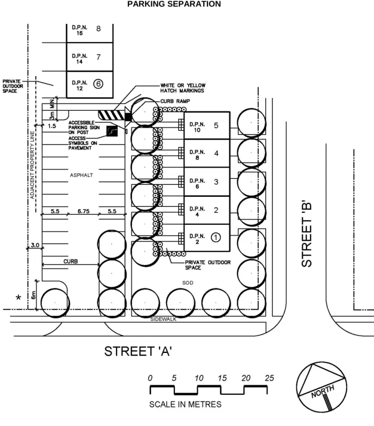
(d) Parking Separation (See Figure 2.1)
(i) Common parking lots should not be closer than 3 m (9.8 feet) to a private outdoor space.
(ii) Private outdoor spaces which are more than 1 m (3 feet) lower than a common parking lot should be separated by not less than 7.5 m (25 feet) with appropriate screening and by not less than 15 m (50 feet) without appropriate screening.
(iii) Parking spaces should be oriented so that headlights and fumes are not directed towards the private outdoor space by using a parallel parking arrangement or by screening with planting or fencing.
(e) Orientation
(i) The private outdoor space should be designed and oriented to take advantage of interesting views.
TABLE 2.1
SETBACK & SEPARATION SPACE GUIDELINES FOR MULTI-FAMILY RESIDENTIAL DEVELOPMENT 1
Built Up Areas Under Redevelopment
Developing Areas
Rowhousing or Similarly
Attached
Apartments Rowhousing or Similarly
Attached
Apartments
Habitable Room Windows
8 m (26 ft.) 6 m (20 ft.) minimum OR ½ the height of the building
whichever is greater to a maximum of 9 m (30 ft.)
8 m (26 ft.) 8 m (26 ft.) minimum OR ½ the height of the building
whichever is greater to a maximum of 9 m (30 ft.)
Non-Habitable 1.5 m (5 ft.) 6 m (20 ft) 3 m (10 ft.) 6 m (20 ft.)
Blank Walls 2 0 m 0 m 0 m 0 m
1 Setback does not include Front Yard Setbacks, being generally the distance between the
front fact of the building and the street line.
FIGURE 2.1
PARKING SEPARATION
*
Note: The clear throat distance varies depending upon the number of parking spaces.3. EXTERNAL FACILITIES AND WORKS PROVIDED IN CONJUNCTION WITH THE SITE
3.1. Objective
To ensure that no person undertakes development unless the municipal services normally required by The City of London are available to service the land, buildings or structure. (See Council policies on the Capital Works Budget, Industrial Oversize Reserve Fund, Urban Growth Capital Works Reserve Fund and the Municipal Services Section in the applicable Zoning By-law). (See also Official Plan Policies 2.6.4, 17.1, 17.2.5, 17.2.6.)
3.2. Design of Works to Be Assumed
Where facilities and works external to the site are provided in conjunction with the development of the site, the plans are to be prepared by a consulting engineer and must be submitted to the Managing Director, Development & Compliance Services & Chief Building Official for approval prior to construction of said works and facilities. Detailed cost estimates are also required of the total cost, including the City's share of such costs. The facilities and work shall be constructed and accepted by the City prior to the occupancy of any building on the site taking place, unless otherwise approved by the City Engineer.
3.3. "As-Constructed" Drawings
"As-constructed" drawings of any facilities and works to be assumed by the City will be required prior to the full release of security. This requirement applies to works on any easement which the City must maintain. Drawings shall be completed to the specifications of the City Engineer.
3.4. Certificate of Works to be Assumed
Facilities and works to be assumed by the City within a public highway, walkway or easement shall be inspected and certified by the owner's consulting engineer. The form of certification is to be substantially the same as the one listed as development agreement standard clause No. 4.
3.5. Works Eligible for a Claim
Some external facilities and works may be eligible for either an Urban Growth Capital Works Claim, and/or the City Services Fund, and/or a Capital Works Budget Claim and/or Industrial Oversizing Claim. Eligibility for these claims must be approved by the City prior to construction and subsequent to entering into a development agreement. 3.6. Security
Security is required to ensure the completion of external works. Security may be reduced as stages of construction are completed.
4. ROAD WIDENING 4.1. Site Plan
(a) The site plan shall show the land to be dedicated prior issuance of the development agreement. The land shall be free and clear of any encumbrances.
(b) The site plan shall show the ultimate road widening, and all buildings, parking access, etc. will be set back beyond the ultimate road widening in accordance with the zoning by-law.
(c) The City of London’s Official Plan establishes a basis for the widths of road allowances. Based on this, the City’s zoning by-law Z-1 sets out the actual ultimate road allowance widths. The zoning by-law also establishes that setbacks for parking, buildings, etc. are to be from the ultimate road allowance. In addition to this, the intersections of some streets will require sight triangles and in some cases increased widenings to accommodate Bus Rapid Transit Systems (BRT) in the future, in
accordance with the zoning by-law.
(d) In some cases, road widenings are required for existing sites where substantial additions or changes are being proposed. Where no road works are proposed in front of the subject property, the dedication is required, however, the property owner may be given permission to continue to use the lands subject to items such as: entry into a modified boulevard parking agreement with the City, provision of insurance to indemnify and save the City harmless.
(See Official Plan Policies 18.2.4, 18.2.5, and Council Policy 25(62).)
5. ACCESS TO AND FROM SITE 5.1. Objective
(a) To provide for the orderly and safe movement of traffic in and out of private properties with minimum interference to vehicular, pedestrian, and bicycle traffic using the public road system, as intended by the Official Plan (see Official Plan Policy 18.2.6).
(b) To ensure that works on the road allowance are up to the standards prescribed by the City as provided for in the Streets By-law, and with the City of London Access Management Guidelines.
5.2. Access Driveway - Definition
Any area constructed within the public road allowance, connecting a paved public street with private property, for the purpose of providing access and egress for motor vehicles to private property.
5.3. Number of Accesses
(a) The number of access driveways should be minimized on all streets. Each development will be analyzed in terms of the site characteristics, including street frontage, land area, traffic generation and parking capacity to determine the desirable number and locations of access driveways. Driveways to arterial streets should be avoided if a site can have an access to a collector street.
(b) The design of driveway entrances located along transit routes will take into consideration the functional aspects of the transit operation, and ensure that driveways are co-ordinated with transit facilities. Relocation of transit stops are subject to the approval of the London Transit Commission and the City. Any such works if approved will be at the sole expense of the developer.
(c) In some cases, property owners will be required to construct a joint access in accordance with the Access Management Guidelines.
5.4. Joint Accesses
Where required, joint accesses with abutting property owners shall be installed and the site plan shall show the location and construction, all in accordance with the standards referred to herein. If the joint access is to be provided for in the future, the site plan shall show the proposed location and the development agreement shall make provision for this as well.
5.5. Location
(a) Access driveways should be located opposite other existing, proposed access driveways, or public streets to avoid offset conditions and associated difficulties with the provision of required left turn storage lanes on the street. In all cases, major access driveways to arterial streets, when permitted, shall be located to allow for effective traffic progression on the arterial route.
less than 1 m (3 feet) shall be blended between the near edge of the driveway and the property line projected at right angles to the curb line. (c) Where more than one private entrance serves the same lands from the
same street, the entrances shall be separated to the satisfaction of the City Engineer.
(d) Where an entrance/exit is divided by an island, a minimum island width of 1.8 m (6 feet) and a point 1.2 m (4 feet) outside of the curb line, may be permitted between adjacent one-way drives serving as a combined entrance/exit facility. Such driveways must be clearly signed as entrance and exit. The detailed design shall accommodate turning radii for large vehicles.
All entrance/exits shall provide a minimum clear throat from the ultimate road allowance onto private property as set out in the Access Management Guidelines.
(e) Spacing of drives serving the same site or adjacent sites should be consistent with the access management guidelines. In some cases, a Traffic Impact Study may be required to confirm access locations and designs in accordance with Access Management Guidelines.
5.6. Angular Placement
The centre line, for a distance of at least 6 m (20 feet), of a two-way driveway shall meet the curb line as close as practical to a 90 degree angle and the centre line of a one-way driveway may meet the curb line at an angle less than a right angle, but not less than 60 degrees.
5.7. Width
The scale, size and intensity of a project may affect the size and extent of a driveway serving a complex. (See Access Management Guidelines)
The minimum width of a drive serving a residential complex is 6.7m and may be increased to accommodate turning movements.
The radius of each side of the drive shall be at least 9 meters.
For Industrial, Commercial and Institutional Uses, the driveways shall be at least 9 meters in width but not exceed 12m in width, and the radius on driveway shall be increased to provide for the size of vehicles potentially accessing these sites. 5.8. Design
(a) All access driveways should be constructed with raised curbs and surfaced with asphalt or other hard surface approved by the City Engineer.
(b) Vertical grades of access driveways should be 2% (1:50) for a minimum distance of 6 m (20 feet) on the site from the street line.
(c) Sidewalks, curbs and gutters should be continuous and level across access driveways (see City of London Engineering standards).
5.9. Abandoned Driveways
These driveways shall be removed and replaced with sidewalks, boulevards, curbs and gutters, all to the specifications of the General Manager of Environmental Services and City Engineer. This work shall be shown on the site plan.
5.10. Property Line Grading
(a) The property line (including the adjacent boulevards) abutting road allowances of arterial and primary collectors shall be graded to blend with the future road grades proposed for the street. City standard, entitled "Subdivision Grading along Arterial and Primary Collectors Roads," shall be used to establish these grades. Where these future grades have not been established yet by the City Engineer, the owner shall at no expense
to the City retain a consulting engineer to obtain the necessary information to establish the future grades and have such approved by the City Engineer.
(b) On all other streets not mentioned in (a) above, the owner shall grade the property line and adjacent boulevards so that they blend with the existing street grade to the specifications of the General Manager of Environmental Services and City Engineer.
(c) The site plan shall show the grades of the property line and boulevards as described in (a) and (b) above.
5.11. Utilities Within Road Allowance
The owner shall, in addition to obtaining a permit of approved works from the City for work within the road allowance ensure that all the utilities are contacted. Underground utility locations must, however, be verified in the field by the respective utilities. Non-standard locations for new utilities or services must be approved by the Utilities Co-ordinating Committee.
In some cases, a Traffic Management Plan will be required to be submitted to demonstrate items such as: how the flow of traffic will be maintained; safety issues; etc. for any work on the City Road Allowance.
5.12. Boulevards
All new, disturbed or reinstated boulevards shall be sodded except boulevards less than 1.0 m (3.0 ft.) in width, between the sidewalk and curb or edge of pavement, which shall be paved with interlocking paving stones, asphalt, or concrete, unless the City Engineer approves sodding. Boulevards 1 metre (3.0 ft.) or wider may be paved with the approval and to the specifications of the City Engineer.
6. PARKING FACILITIES AND INTERNAL DRIVEWAYS 6.1. Objective
(a) To provide for adequate parking and loading facilities, orderly circulation within the parking area and an attractive community appearance (see Official Plan Policies 6.11, 7.2.15, 8.5, 9.1.7.7, 12.6.1, 14.2.2.10 and Council Policy 25(56)).
(b) To encourage site planning and architectural design that is compatible with
effective transit services. 6.2. Off-Street Parking Facilities
(a) Number of Spaces
(i) Refer to the applicable zoning by-law for the total number of required parking spaces.
(ii) Visitor Parking: Multi-unit residential development including cluster detached dwellings developments with a total of three or more units shall provide a common area(s) for visitor designated and signed parking spaces. One (1) visitor parking space shall be provided for every ten (10) dwelling units. The number of visitor parking spaces may be included within the total number of parking spaces required by the applicable zoning by-law. Where feasible, visitor parking shall be centrally located to serve all units. These may be distributed in small clusters to better serve the complex. Driveways or parking spaces that are, or may be perceived for the exclusive use in association with a dwelling unit will not be considered as a visitor parking space.
(iii) Barrier free parking is to be provided for buildings in accordance with the Ontario Building Code and in accordance with the zoning by-law, where identified.
(b) Location - Parking areas should be no closer than 3 metres (10 feet) to street line and1.5 metres (5 feet) to a property line.
(c) Commercial parking areas may be located in the interior and/or rear yards, and are discouraged from being in the front or exterior yards depending upon:
(i) predominant parking location on sites in the vicinity, location of adjacent commercial parking areas;
(ii) existence of adjacent non-commercial land use; and (iii) convenience to proposed uses.
(iv) prohibitions in the zoning by-law.
(v) in cases where parking is permitted in the front yard or exterior yard, adequate screening is required.
(d) Where feasible, parking should not be permitted in a yard adjacent to a residential zone. Where such parking is permitted, adequate screening will be required (see Section 9 on landscaping).
(e) Schools – car parking and bus loading areas are to be located on private property.
(f) Residential parking areas should be located:
(i) in view of dwellings and activity areas, preferably 45 m (150 feet) maximum walking distance;
(ii) adjacent to pedestrian systems;
(iii) convenient to the building entrances; and
(iv) no closer that 3 m (10 ft.) to a window of a habitable room.
(g) Where the applicable zoning by-law regulations do not specify the size of parking spaces and aisles, the relevant standard minimum parking dimensions set out in Figure 6.1 and Table 6.1, shall be used and the spaces shall be clearly marked.
(h) Parking rows should be delineated by poured concrete curbs or planters at each end to prevent uncontrolled internal traffic movements and generally to confine traffic to designated parking aisles or driveways.
(i) Parking areas shall be designed so as to not require vehicles to reverse from the property onto a public street.
(j) Access to and from parking aisles should be minimized along main feeder driveways.
(k) No more than 15 parking spaces should be permitted in a row without an interrupting minimum 3 m (10 ft.) width planting area.
(l) For developments abutting transit routes, parking areas are encouraged in locations to the side or rear of the building. The extent to which parking areas are feasible in locations to the side and rear of commercial buildings will be subject to both the visibility of customer parking as a marketing factor and public safety concerns respecting surveillance from abutting streets and buildings.
(m) Barrier free parking spaces shall be located in close proximity to the building’s barrier free entrance.
6.3. Internal Driveways
(a) Main internal driveways which are heavily travelled should be delineated by raised curbs or equivalent barriers and be designed not to have
parking spaces on either side where possible.
(b) Intersections of driveways and parking aisles should be at a 90 degree angle.
(c) The horizontal alignment of all driveways should be geometrically sound, but lengthy straight sections should be minimized to discourage speeding. (d) The design of driveway and parking aisle intersections should ensure
adequate visibility of intersecting traffic movements.
(e) In large commercial developments, main internal driveways should not be located abutting building entrances in order to minimize pedestrian and vehicle conflicts.
(f) Driveways adjacent to a building should be a maximum width of 6.7 m (22 ft.) for two-way traffic and 3.35 m (11 ft.) for one-way traffic to deter parking in the driveway.
6.4. Paving
All surfaces used for parking or vehicular circulation shall be paved with asphalt or other equivalent hard surface approved by the Manager, Development Services & Planning Liaison. Consideration may be given to alternative surface materials such as turfstone, cobblestone, etc., that allow precipitation to percolate into the soil, for any parking spaces provided over the minimum number required. All materials used should be capable of being indelibly marked to designate the parking spaces provided.
Note: See the Lighting, Grading, Landscaping, and Fencing Sections for these aspects of parking lot design.
TABLE 6.1
OFF-STREET PARKING AREA
Location - preferably not adjacent to a residential zone - minimum 3 m to street line
- minimum 1.5 m to property line
Layout - See Figure 6.1
- maximum in uninterrupted row - 15 Internal Driveways
Intersections Width Minimum
Width Maximum
- 90 °
Parking Parking Two Sides One Side 90 ° 6.5 m 7.5 m 60 ° 4.5 m 5.4 m 45 ° 3.4 m 4.2 m 30 ° 3.1 m 3.8 m Parallel 3.8 m 3.8 m
- adjacent to a building n wider than the minimum width Pedestrian Circulation - normally no separate facility required
Paving - asphalt or other hard surface**
Parking Module - if overhang space of 0.6 m is provided, the module of parking and manoeuvring space may be reduced accordingly.
* Including units served by a connecting local road. **Including previous paving where feasible.
FIGURE 6.1
FIGURE 6.2 PARKING STRUCTURES
Consideration should be given to the use of parking structure in higher intensity developments. These can consist of underground parking, sunken open air parking lots with usable roof decks or sundecks over individual parking spaces. Parking structures should be architecturally treated and landscaped. Parking spaces and driveway isles are to be consistent with surface parking driveway standards. The entrance drive to a parking structure should be designed in accordance with Figure 6.2.
6.6. Off-Street Loading Facilities (a) Definitions
(i) Loading Facility means a loading space or bay along with any manoeuvring area required as part of the loading facility and which is located on the site, either within a building or adjacent to a building.
(ii) Loading Space means a paved area exclusively for loading and unloading trucks either within a building or adjacent to a building and does not include any manoeuvring space.
(b) Number of Spaces
Refer to the applicable zoning by-law. (c) Minimum Size
Where under the applicable zoning by-law there are regulations concerning loading facilities but no dimensions are given, then the following shall apply:
Width Height Length
Industrial 3.6 m (12 ft.) 4.5 m (15 ft.) 20 m (65 ft.) Other 3.6 m (12 ft.) 4.25 m (14 ft.) 9 m (30 ft.) (d) Access
All loading spaces or loading areas should have associated space on the property to provide truck manoeuvring. Such areas should be shown on the plan and none of these vehicles will be permitted to reverse onto or from the street abutting the property, unless otherwise permitted in the zoning by-law.
Roads providing access to building fronts and fire routes are to be designed to support emergency vehicles, e.g. fire trucks.
(e) Location
Access to loading facilities may be by separate access or by an internal driveway serving a parking area. Loading spaces are to be located in accordance with the zoning by-law.
(f) Paving
All loading spaces, manoeuvring areas and driveways should be hard surfaced with suitable materials to the satisfaction of the City Engineer, i.e., concrete, asphalt, lockstone, etc.
(g) Joint Loading Facilities
In shopping centres or other similar integrated development, the use of joint loading facilities to serve all or several individual businesses will be encouraged.