INFORMATION SEEKING BEHAVIOR OF GEOLOGISTS WHEN SEARCHING FOR PHYSICAL SAMPLES
Sarah Ramdeen
A dissertation submitted to the faculty at the University of North Carolina at Chapel Hill in partial fulfillment of the requirements for the degree of Doctor of Philosophy in the
School of Information and Library Science.
Chapel Hill 2017
Approved by: Claudia Gollop Betty Adrian
Jane Greenberg Barbara Moran
iii ABSTRACT
Sarah Ramdeen: Information Seeking Behavior of Geologists when Searching for Physical Samples
(Under the Direction of Claudia Gollop)
Information seeking is “a conscious effort to acquire information in response to a need or gap” in your knowledge (Case, 2007, p. 5). In the geosciences, physical samples such as cores, cuttings, fossils, and rocks are primary sources of information; they represent “the foundation of basic and applied geoscience research and education, and underpin industry programs to discover and develop domestic natural resources” (National Research Council, 2002, p.8). This
dissertation investigates the information seeking behavior of geologists when searching for physical samples. It takes a unique approach by looking at physical objects as information sources, as opposed to past studies which focused on print literature (Bichteler & Ward, 1989; Joseph, 2001).
Data collection was twofold. First I administered two questionnaires to state geological surveys. Thirty-five state geologists and 28 repository managers responded. The results capture an overview of these science data centers and their handling of collections of physical samples. State geological surveys were selected as they are a distinct type of facility which are similar to libraries. Like libraries, these institutions’ missions dictate maintaining a collection as well as providing access to their diverse data holdings.
iv
a model of their information seeking behavior. Some behaviors were dependent on one’s role within an organization, suggesting a division of labor in the research team. Many behaviors related to a researcher’s knowledge of the domain, e.g., knowing where to look, who to talk to, and how to determine the quality of the information found. The most frequently used search process by interview participants was relying on their social network to recommend or locate samples.
The results of this study suggest a number of recommendations and research
v
vi
ACKNOWLEDGEMENTS
There have been so many people to support me though this work, both personally, and professionally. First, I would like to thank my family. Mom – you have always supported my adventurous ideas, a PhD included. I learned to think about things differently from you, and that has been vital in being a researcher. Dad – You might tease me about being in school for the rest of my life, but you more than anyone understood and respected this process. Thank you, Carrie, Zeb, Kim for everything. I have such a big family, and they have always been there for me. In no particular order, Grandma, Grandpa, Barbara, Ellen, Kathy, Kurt, Kenny, Richie, Taylor, Robin, and Cathy.
I am eternally grateful and very appreciative of my committee: Claudia Gollop, Betty Adrian, Jane Greenberg, Barbara Moran, and Barbara Wildemuth. Thank you for your time, your guidance, and your encouragement. This has been a long process and I truly appreciate your continual support.
Thank you to everyone in the Earth Science community. Thank you to the folks at the Florida Geological Survey. Jon Arthur gave me my first job as a geologist, Ken Campbell supported my efforts to pull in LIS ideas into my work, and Jackie Lloyd, you had such faith in me and my abilities and you have been a wonderful example and mentor.
Thank you to everyone in the Earth Science Information Partners, the Earth and Space Science Informatics Focus Group of the American Geophysical Union, the Research Data
vii
funding opportunities. I have been privileged to work with so many amazing women in the geosciences. In particular Ruth Duerr and Denise Hills. I don’t know what I would do without you two, thanks for keeping me sane!
Thank you to the alumni of the Archival Education and Research Initiative. AERI provides a safe space for students to explore their research ideas and really develop a community. Devan Donaldson and Edward Benoit, you two are amazing.
Thank you to all of my friends. The lines blur sometimes between my research
communities and my friends and that is a good thing. But that means I wasn’t sure where to list some of you! Thank you to Elizabeth Parker, Diana Greenslade, and Jessie Nelson. You three are more than my best friends, you are sisters. Thank you to all of my classmates over the years at UNC: Amber, Rachael, Julia, Laura, Emily, Alex, Amanda, John, Sumayya, Angela, Tessa, Kjersti, Jewel, and Simon. I needed all of you. Brenda, Jeff, Josiah, and Eric you should be honorary members of that list. Thank you to the Solorooers, my family of hippies. Ross, Kathy, Shea, Lucas, Ryan, Glenn, Dan, Tom, and so many more. You all have known me since before I even thought about getting a PhD. You kept me grounded and calm. Thank you to all my friends from various parts of my life: Jenn, Kim, Candice, Gaines, Brent, Elise, Tyler, Eric, Melody, Daniel, Rachael, Nancy, and Ona. Thank you to my friend Kenji Butler for letting me ramble. And thank you to Michael Hysell for the encouragement and support.
viii PREFACE
ix
TABLE OF CONTENTS
LIST OF TABLES ... xvi
LIST OF FIGURES ... xvii
LIST OF ABBREVIATIONS ... xviii
CHAPTER 1: Introduction ... 1
Geological collections at state geological surveys ... 3
Geological data. ... 3
Evolution from museums to libraries. ... 8
Users of geological data. ... 9
Geological surveys. ... 11
Stewardship challenges ... 13
Historical view on preservation. ... 13
Current stewardship efforts. ... 13
x
Justification for research ... 20
Study Overview ... 22
CHAPTER 2: Literature review ... 24
Information in the earth sciences ... 24
Physical objects as information sources in the earth sciences. ... 24
Geological data. ... 28
Representation of knowledge. ... 30
Information organization. ... 31
Why do we keep scientific data collections? ... 34
Scientific collections of information ... 37
Information behavior ... 40
Ellis’s model of information seeking. ... 43
Criticism and limitations of Ellis’s model. ... 47
CHAPTER 3: Methods ... 50
Research question ... 50
xi
‘Descriptive survey’ – understanding existing conditions. ... 52
Questionnaire distribution. ... 55
Data analysis. ... 57
Phase two: Interviews ... 58
Question development. ... 58
Sample... 60
Interview procedures. ... 61
Data analysis. ... 62
Trustworthiness of the findings. ... 66
CHAPTER 4: Results ... 69
Phase one: Questionnaires ... 69
Results. ... 69
Summary. ... 83
Phase two: Interviews ... 83
xii
Results. ... 86
Summary. ... 104
Comparisons across research stages ... 104
Use of collections. ... 105
Regions represented. ... 106
Analysis of other materials ... 106
Databases. ... 107
State survey Data at risk evaluation. ... 108
Community discussions. ... 109
Services. ... 110
CHAPTER 5: Discussion ... 111
Information seeking ... 111
Model. ... 114
Seeking. ... 117
Social networks and personal contact. ... 119
xiii
Resources by region. ... 121
Education in searching. ... 121
Connection to science data centers ... 122
Nature of the data ... 126
Limitations of this study ... 127
CHAPTER 6: Conclusion ... 129
Future research ... 131
APPENDIX A: GLOSSARY ... 133
APPENDIX B: PROTOCOLS FOR ARRANGING A VISIT TO STATE COLLECTIONS ... 136
Alaska. ... 136
Illinois. ... 136
Indiana... 136
APPENDIX C: INITIAL EMAIL AND QUESTION REQUESTS ... 138
Email to state geologists. ... 138
xiv
APPENDIX D: STUDY DESCRIPTION ON WEBSITE ... 141
Introduction. ... 141
Research Objectives. ... 141
Part one: State geologists and repository managers. ... 141
How to participate. ... 141
Part two: Patron Interviews. ... 142
Expected outcomes. ... 143
Questions... 143
Interviews – background. ... 143
APPENDIX E: QUESTIONNAIRES ... 146
State Geologists. ... 146
Introduction. ... 146
Questions... 146
Repository managers. ... 151
Introduction. ... 151
xv
APPENDIX F: RECRUITMENT SCRIPT ... 156
APPENDIX G: LIST SERVE RECRUITMENT ... 158
APPENDIX H: INTERVIEW GUIDE ... 159
Obtain consent. ... 159
Interview guide. ... 159
APPENDIX I: INFORMATION AND CONSENT ………..162
APPENDIX J: EXAMPLE OF SEARCH BEHAVIOR ... 165
Example one... 165
Example two. ... 166
xvi
LIST OF TABLES
Table 1. Examples of materials in Geoscience Collections ……….…….29
Table 2. Three types of knowledge ………...32
Table 3. Categories for Ellis’s Models ……….………...44
Table 4. Requirements, policies and plans related to collections………..73
Table 5. Facility needs ……….…74
Table 6. Discovery and access (N=32) ………...76
Table 7. Physical samples at state surveys ………...77
Table 8. Primary geographic region ………...77
Table 9. How does your organization provide outside access to this collection? (Select all that apply)…..……….………...81
Table 10. Description of participants………...85
xvii
LIST OF FIGURES
Figure 1. Examples of materials in a geological collection ………..4
Figure 2. Examples of materials in deterioration ………..7
Figure 3. Sample-subsample relationship ……….30
Figure 4. Subtypes of science data collections ………...…..39
Figure 5. Information Behavior ………....41
Figure 6. Wilson (1999a)’s proposed diagram of Ellis’s model ………...45
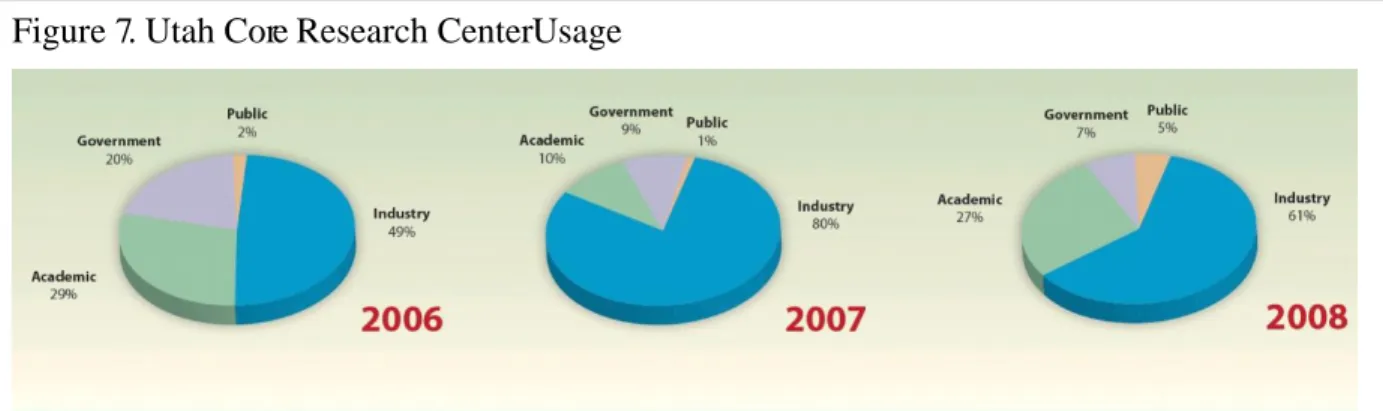
Figure 7. Utah Core Research Center Usage ………....57
Figure 8. GSA Regions ………...……..71
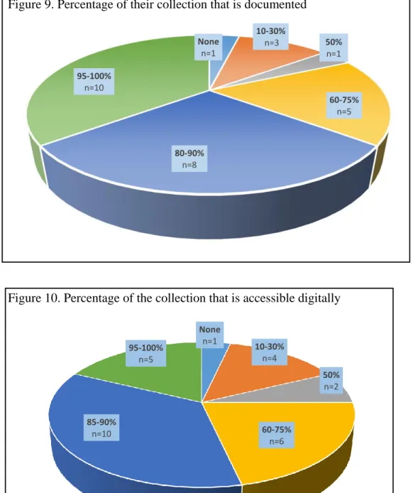
Figure 9. Percentage of their collection that is documented ………….………79
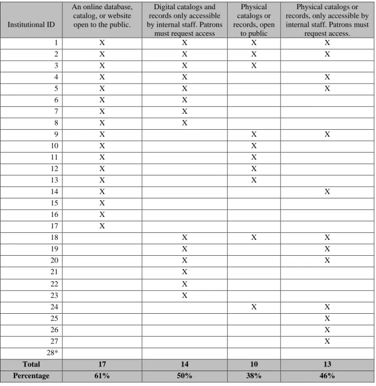
Figure 10. Percentage of the collection that is accessible digitally …..………...79
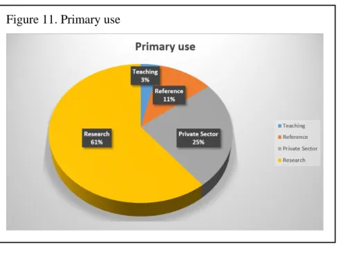
Figure 11. Primary Use ……….82
Figure 12. Yearly visitors ……….83
xviii
LIST OF ABBREVIATIONS
AASG Association of American State Geologists
AEC Atomic Energy Commission
AGI American Geosciences Institute
CDA Common Data Access Limited
CODATA Committee on Data for Science and Technology
CSDCO Continental Scientific Drilling Coordination Office
DataONE Data Observation Network for Earth
ESIP Earth Science Information Partners
GCMS Geologic Collections Management System
GMC Alaska Geologic Materials Center
GMRWG Geologic Materials Repository Working Group
GSA Geological Society of America
IGSN International Geo Sample Numbers
IODP Integrated Ocean Drilling Program
xix LIS Library and Information Science
MGRRE Michigan Geological Repository for Research and Education
NGGDPP National Geological and Geophysical Data Preservation Program
NGDS National Geothermal Data System
NRC National Research Council
NSTC National Science and Technology Council
OAIS Open Archival Information System
RDA Research Data Alliance
SDC Scientific Data Collections
SESAR System for Earth Sample Registration
1
CHAPTER 1: INTRODUCTION 1
The first state geological survey was founded in 1823, and by 1840 there were at least 15 states with geological surveys (Association of American State Geologists (AASG), 2007). The function of a state geological survey varies from state to state, but the underlying purposes of the state surveys are consistent: to collect and maintain information about their state’s geology and to share these resources with the public. “In all states, a major purpose was to locate, describe, and publicize such natural resources as salt and mineral springs, building stones, shales, clays, slates, coal, and ores” (Hendrickson, 1961, p. 361). At the time of their founding in the mid 1800’s, state geological surveys represented “government-supported science” and were often “the first contact between the public and science” (Buchanan, 1992, p. 62).
“The early state surveys were intended by the legislatures to be only short-term undertakings” (Boscoe, 2003, p. 293). Initially, geologists (usually academics) were hired to conduct specific tasks, but as states evolved and the industry changed, roles changed as well (Buchanan, 1992). States’ collections often began as personal, individual collections, which later became the base of the state geological repositories. Given that they are personal, they contain qualities that make them unusual and perhaps more difficult to manage, similar to small science collections.
In 2008, Western Michigan University's Michigan Geological Repository for Research and Education (MGRRE) and the state’s geological repository, acquired a large amount of rock
2
core from the Mosaic company. The company owned a potash mine from which the cores were drilled. They no longer wanted to store them and offered the cores as a donation to the university (Zipp, 2013). Two administrators at the MGRRE, realizing the research value of these materials, drove their own vehicle to pick up the boxes of cores. “It took four pick-up loads to bring all the material down to Kalamazoo” (Zipp, 2013). These samples were later used to verify the quality of amount of potash (a mineral used in fertilizers) in a rediscovered mineral deposit in West Michigan (Zipp, 2013). This discovery is estimated to be valued at $65 billion dollars and has the potential to have a major impact on the local economy. It might lower the costs of farming in the Midwest where farmers must pay to import potash from Mexico, Canada, and Russia. A new mine could create construction jobs as well as full time jobs at the site (Zipp, 2013). These ‘unwanted’ samples have become a major resource for the state of Michigan, and it was fortuitous that MGRRE saw the value in them as legacy data and had the opportunity (and resources) to preserve them.
On January 17th, 2001, a natural gas explosion occurred in downtown Hutchinson, Kansas. Two local businesses burned down as a result. Two days later, another leak occurred under a mobile home, and two people were killed. As a safety precaution, the city was
3
Geological Survey had maintained these legacy data as part of their repository. This reuse, use beyond their original purpose, helped the investigators better understand how the natural gas was leaking from a nearby underground storage facility (Cutler & Maples, 2002, p.16). As the NRC (2002) summarized, “having immediate access to critical geoscience data and information played a crucial role in facilitating rapid response to a local crisis” (NRC, 2002, p. 1).
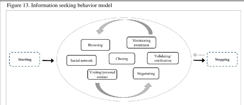
The examples above demonstrate the importance of geological collections, their continued maintenance, and their potential for reuse. In the U.S. Geological Survey Geologic Collections Management System (GCMS), reuse is referred to as re-sampling or secondary sampling and is “the act of retrieving an archived sample for the purpose of additional scientific inquiry” (Geologic Materials Repository Working Group (GMRWG), 2015, p. 33). This study investigates information seeking behavior in relation to the reuse of geologic samples. In particular, objects which have been gathered with the intention of representing scientific geological information. Participants were recruited from the patrons of the core and cutting repositories within state geological surveys. Results of this qualitative inquiry were used to develop a model.
Geological collections at state geological surveys Geological data.
4
the documentation. If this connection is lost, the value as data becomes lost and the physical item just becomes a rock again.
Such physical geological data include items such as rock core and cuttings, thin sections and fossils, as illustrated in Figure 1. Most physical geological materials, when properly maintained, can be stored for future access without the risk of major sample degradation. For example, a properly stored and curated core sample from a well drilled in 1907 can produce new knowledge today and in the future. The data that these samples hold can be reused, reanalyzed, potentially using previously unavailable technology, and contribute to studies beyond the scope of the original project. The materials in these collections may be 1) examples of earlier
observations or results, 2) standards, kept for the base of future comparisons, 3) resources for research into geological issues, 4) collections of rare or valuable items, 5) resources used for education and training future geologists, and 6) proactively collected materials for future use (National Science and Technology Council (NSTC), 2009).
Figure 1. Examples of materials in a geological collection
5
In a recent White House memorandum, Holdren (2014) states “scientific collections provide an essential base for developing scientific evidence and are an important resource for
scientific research, education, and resource management. Scientific collections represent records
of our past and investment in our future”. It is important to maintain collections of scientific data not just for new research but to confirm previous work. As geologist and historian Jackson (1999) explains, “a fundamental tenet in science is the need for viable checking and
reproducibility of results. Re-analyses may not be undertaken for some time after the original research, but require preservation of the original material worked on in order to be of any value” (p. 423). Raw data, which may include physical samples, may be used to conduct reliability and validity checks on the work being produced. Heidorn (2008) stresses the idea that science is based on theories and theories are created based on replicable data. If the data are inaccessible and the theory cannot be replicated, scientific results would be unsubstantiated. “The availability of the data behind experiments helps to insure scientific integrity by keeping the process open to external evaluation” (Heidorn, 2008, p. 286).
6
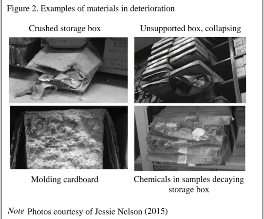
The examples in the introduction demonstrate the value of geological collections. However, long term management and storage has not always been factored in to the data collection process. Differences in management might depend on the intended use, the focus of metadata, and other institutional variances. This may lead to valuable collections being
abandoned or left deteriorating (see Figure 2) at the end of a project. This is not due to neglect, or lack of care, but a lack of resources and focus. State geological surveys face a variety of preservation challenges in relation to their geological data collections. Many facilities would like to have full maintenance for their samples, however these organizations do not have the proper resources to do so or lack a standard procedure for curation (NRC, 2002); resources include staffing, funding, and space.
7
Long tail data are important as they are “a breeding ground for new ideas and never before attempted science” (Heidorn, 2008, p. 282). When they are inaccessible, these sets of data may be lost to the public beyond the finished publication. In his 2014 testimony, Gooding explains that state geological surveys get many of the items in their collections from donations (H.R. 5066, 2014b). These donations come from a wide range of individuals including scientists from “coal, oil and gas, mining, highway construction, and environmental investigations;
construction projects; quarry operators; university research; and federal and state projects” (H.R. 5066, 2014b, p.3). Each has their own method of documentation, data collection, and curation. This can lead to complicated hybrid collections at the state survey level that, owing to their complicated curation schemes and lack of standardization, and may become lost.
Concerns for physical items also includes concern for their digital surrogates. In order to discover and access these geological collections, adequate metadata, records and other text based
Figure 2. Example s of materials in deterioration
Note
Photos courtesy of Jessie Nelson
(2015) .
Crushed storage box Unsupported box, collapsing
8
materials are needed. These may be found in paper records, but are increasingly being digitized or digital born. Without this documentation, various aspects of scientific information contained in physical geological materials may be lost.
Evolution from museums to libraries.
The origins of museums and geological collections are closely linked. Geology uses analytical or comparative ways of ‘knowing’; research in geology involves deconstructing strata “into elements, in order to make classifications, or to better understand (and regulate) technical processes” (Pickstone, 1994, p. 113). Pickstone (1994) calls it a ‘museological science’ because “geology and mineralogy [are] also, in part, sciences of collections” (p. 117). When geology was still developing as a scientific field in the 1800’s, the role of the curator became very
important in managing geological collections (Knell, 2000; Taylor, 1988). These managers were often expert geologists (Knell, 2000). Museums recognized the need to have someone manage and curate a collection to not only prevent it from falling into disrepair but also because of the value added to the collection through arrangement, identification, and cataloging of the rocks, fossils and other materials in the collection. For example, ‘amateur’ scientist William Smith’s skills were much sought after as a curator in order to get the full value from geological
collections (Knell, 2000). Smith is now known for pioneering the field of stratigraphy. Museums keep collections for a number of reasons, including making them available for research, responding to public requests, educational activities, publishing scholarly works, and general interest publishing (Orna & Pettitt, 1980).
9
Many states specifically included in their legislation the requirement that the museum or
collection should be curated by a geologist (Hendrickson, 1961). In Kentucky, this was tasked to the inspector of mines, who “in addition to his duties as such inspector, shall be curator of the cabinet and other property of the geological survey or department” (Merrill, 1920, p.123).
While many states still maintain geological collections, the terminology has changed as state geological museums have evolved into active, living collections. These changes developed as the state surveys moved from projects led by a single person or small team, to permanent institutions which had distinctly different needs and interacted with a larger number of stakeholders. These once-museums are now called repositories2 or sample libraries.
Specifically, state surveys have what the United States Geological Survey’s (USGS) GMRWG call active repositories – “a permanent facility that assumes responsibility for the long-term storage and maintenance of a collection (or collections) of related materials” (2015, p.11). In line with this move away from museums, in 1975 the AASG formed a ‘core and sample library’ committee, which still exists today (Cobb, 2008). As of 2015, of the twenty states which reference their collections in the annual State Geologist Journal. Twelve states refer to their collections as core or sample libraries, four states refer to these collections as repositories, and only one state refers to their collection as a museum (AASG, 2015). The term sample library provokes the concept Cragin and Shankar (2006) call ‘reference collections’ which are large-scale, and typically serve science and education, among others.
Users of geological data.
According to Gooding, manager of the Kentucky Geological Survey’s well sample and core library, state geological data collections “are used by scientists from the U.S. government,
10
geological surveys, educators from academia, exploration, development and industry geologists, consultants, operators, students and the general public” (H.R. 5066, 2014b, p.1). Hawaii’s state survey reports “requests for information, technical data, and rock samples are handled on a routine basis” (Socolow, 1988, p.90). The makeup of the current user community and how they access the collections is unclear which supports the need for this research.
As part of the first granting phase of the National Geological and Geophysical Data Preservation Program (NGGDPP), the USGS sent out a questionnaire to the state geological surveys. The questionnaire included questions about frequency of collection use, demographic information about users, and other metrics related to the state surveys’ sample repositories. This is invaluable information, which was never published. There are currently no consistent
reporting methods or published findings related to this type of information. Even the NRC’s 2002 report is missing this information. The exact variation in the size and scope of these
collections is unclear. Troutman (2009) curates a list of these types of collections on his website, but it is incomplete and was last updated in 2009. The annual State Geologists Journal includes some of this information as volunteered by the state surveys but it is inconsistent. Some states report linear feet of core reviewed per year but not the number of sample sets reviewed or the number of visitors. This format of describing usage is also incomplete. A useful analogy to this situation is the documentation of the number of pages checked out from the library without including information on the number of patrons, the number of books, or perhaps the length of each book. The first phase of this research collects information on the variations and use of these collections.
“Information Seeking Behavior is the purposive seeking for information as a
11
person searches for information about knowledge, which includes scientific data.Understanding the user community is a challenge with scientific data. Parsons and Duerr (2005) suggest data providers may have many assumptions about the users of their data. It may be difficult to precisely identify the user community beyond the organization that originally collected the materials. Organizations that provide access to their collections through online portals can collect usage statistics. Collections that require in-person visits often keep a visitor’s log, but that does not give a clear picture of potential users.
When managing data, there may be many assumptions about users. For example, one may assume all users will have similar knowledge of how the data should be used or that these users have similar education or disciplinary backgrounds. This assumption does not take into account lack of knowledge and customs of the specific organization that collected the data. The NRC (2002) states “using past observations in entirely new ways not envisioned when the data were initially collected” will help expand our understanding of the universe, this includes the unexpected user (p. 13).
In 1911, in response to feedback from the community of geologists and engineers, Hayes (1911) summarized, “information concerning state geological surveys is difficult or impossible to obtain” (p. 5). Is this still true today? Cragin and Shankar (2006) suggest a key problem with the small or dark science is that “[w]e do not fully understand the ways in which small (often local) data collections become more public or shared collections” (p.187). Addressing these questions will involve engaging the archival and information science fields (Ramdeen, 2013).
Geological surveys.
12
methods of maintaining their collections and there is a need for consistency. Additionally, as noted above by Gooding (2014), state survey collections often house donated materials and donors standards vary. Concerns over sustainability and interoperability are high as scientists are concerned about accessibility for future researchers, particularly with regards to metadata for these physical objects.
The GMRWG (2015) states that the role of the USGS is to provide “the Nation with fundamental geochemical and geophysical data necessary to address major societal issues involving geologic hazards and disasters, climate variability and change, energy and mineral resources, ecosystems and human health, and ground-water quality and availability” (p. 22). In addition to the Federal survey, state geological surveys “play an important role in generating and disseminating information related to mineral resources” (NRC, 2003, p.25). The NRC (2003) stresses that the role of these organizations is to be an unbiased “source of science and
information” (p. 25). These collections represent irreplaceable materials as “some of the sources of these collections are now reclaimed, flooded, or otherwise inaccessible” (NRC, 2002, p.53). In addition to being irreplaceable, these collections cost millions of dollars to acquire and would be expensive to recollect (H.R. 5066, 2014b). The report warns that sources of information from the private sector are often proprietary and not made available to the public. Private
13
In industry, the value of these collections may only be realized once the materials have been de-acquisitioned or destroyed. In 2011 Common Data Access Limited (CDA) &
Schlumberger issued a report addressing the “business value case for data management.” They suggest that the effort involved with recreating these types of legacy data are difficult or
potentially impossible and yet the commercial value is great. This had led to a decision to re-find the original materials among retired workers rather than recreate them (CDA, 2011). Stewardship challenges
Historical view on preservation.
Historically, state geological surveys have collections of geological data and act as both active and historical science data centers for their region (NRC & Leighton, 1932; Cragin & Shankar, 2006; & GMRWG, 2015). At the 1926 annual meeting of the AASG, representatives voted to support the NRC’s efforts to salvage well records, “this was perhaps the first attempt to preserve samples and records, a movement that is undergoing a resurgence in the 2000’s” (Cobb, 2008, p. 61). During the 1950’s, the AASG decided “that the archiving of drill core and data was a function primarily of the states and not of a national organization” (Cobb, 2008, p.103). In the 1970’s, the AASG passed a resolution to endorse the Bureau of Mines’ efforts “to develop an efficient and economical national system of repositories for drill cores and other samples of geologic materials” (Cobb, 2008, p.116). During this same time period, the state surveys voted against the formation of regional sample repositories, instead supporting a national core catalog, which is only now being developed.
Current stewardship efforts.
According to the USGS’s data lifecycle, providing access to materials is only one aspect of stewardship (Faundeen et. al., 2013). In a letter to the editor from 1817, the idea of public use and access to geological collections is highlighted as an important impact on scientific
14
preceding inquirers and to extend their observations to other places” (Philosophical Magazine Series 1, 1817, p. 271). In the past decade, there has been growing attention to preserving and managing legacy collections of geoscience data, a trend first attempted by the AASG in the 1920’s and now seeing a return to importance starting in the early 2000’s (Cobb, 2008). This includes efforts by the USGS and the AASG to promote access to collections, as well as position statements from member societies such as the Mineralogical Society of America, American Geophysical Union, Geological Society of America, and the American Association of Petroleum Geologists. The American Geosciences Institute (AGI) has a complete listing of these and other member societies’ position statements on their website3. In 1997, AGI published a directory of geoscience data repositories in the U.S., it was initially intended to be revised every two years (Claudy & Stevens, 1997). The directory has not been updated since its creation.
In a 2002 report, the NRC pinpointed two major areas of concern for the preservation of geological collections: metadata and curation. They believe these two facets are critical in enabling trust in the data for reuse by someone other than the original researcher. In their report, metadata is defined as the accompanying documentation that gives one the ability to find and retrieve physical samples and their supporting documents4. This documentation “includes information about the age, location, depth, originator, and the date acquired” for an item in a collection (NRC, 2002, p. 9). Additionally, metadata may be used as a digital surrogate for the physical sample. Curation refers to the process of proper management, storage, and access to the geological specimens. Curation includes such steps as appraisal, disposal, and use of data. These
3 http://www.americangeosciences.org/policy/policy-positions/membersociety-positionstatements#datapreservation
4It is worth noting that in the NRC’s definition of metadata, they do not address the information about an object that
15
three points are key in the data lifecycle and their context to this research will be discussed further in the literature review.
In 2005, the Energy Policy Act established the NGGDPPunder the direction of the USGS (USGS, 2014a). The act is currently being reviewed for reauthorization and has foundations in the work of many organizations including the NRC and the AASG. The purpose of the
NGGDPP is to provide for the archiving of geoscience materials, to create a national catalog of these archival collections, and to provide technical and financial support to the organizations which collect these materials (USGS, 2014a). One of the outcomes of this program was the rescue of the Potash samples in Michigan as mentioned in the introduction.
Over the last 13 years, nearly all states (with exceptions like that of Georgia, see below) have engaged in data preservation efforts of some variety to ensure long term access to their collections. This includes taking part of the 2002 study by the NRC, the NGGDPP starting in 2006, and the development of the National Digital Catalog (USGS, 2014b). The National Digital Catalog provides a search interface for accessing and interacting with geological collections, particularly at the state and federal level. It is designed to be similar to a union catalog as
opposed to an extensive resource. In 2009, the AASG co-hosted a Geoscience Data Preservation Techniques workshop with the NGGDPP (Steinmetz, Pierce, & Hill, 2009). Other efforts at the state level include the National Geothermal Data System (NGDS). State geological surveys are among the largest contributors to the NGDS, and its catalog contains documents and datasets that will help lead searchers to physical sample resources.
16
Johnston, 2014; Hills, 2014; Walker, et. al. 2015; Wyborn, & Evans, 2015;etc.). The
Geoscience Information Society and the GSA Geoinformatics Division sponsored a session in 2014 titled “Where in the World? Access and Availability to Geoscience Data”. Talks included topics such as locating ‘old’ data, citing geological data, and challenges faced by librarians and the scholarly communication community in relation to geological data. In 2015 the
Geoinformatics Division’s session focused on cyberinfrastructure and data services.
17
In a broader prospective, the Research Data Alliance (RDA) and the International Council for Science’s Committee on Data for Science and Technology (CODATA) also have interest groups working on physical samples and cyberinfrastructure but they are not as far advanced56.
Needs related to stewardship.
All collections, especially living collections, need adequate management. In a recent Eos article, Rep. Holt (N.J.) states, “[scientific collections are] not static museum pieces. These collections are used, should be used, will be used, day by day. It is hard to imagine what future researchers would say if we allowed this [material] to disintegrate or disappear” (Showstack, 2014, p. 351). Though state survey collections are valued, the administration of them has changed, especially as they evolved from museums to active collections. These administrative changes have revealed a great need for preservation efforts. As Taylor (1988) asserts (in relation to museum collections), “calling your spare researcher or technician a ‘curator’ doesn’t confer the ability to curate” (p.119). In 2002, the NRC found that geological collections were in disrepair and under-staffed, leading to these collections of legacy data being at risk of loss.
5 https://rd-alliance.org/groups/metadata-standards-attribution-physical-and-digital-collections-stewardship.html
6 http://www.codata.org/task-groups/management-of-physical-objects Case example:
18
Historically, state survey collections are at high risk for being lost for a wide variety of reasons including the status of state surveys as research institutions in a governmental system. “From the name, state legislators assumed that surveys would exist until the job was completed, then they would go out of business” (Buchanan, 1992, p.63). Funding is also an issue. Early state surveys were originally intended to be short-term endeavors (Boscoe, 2003). As time went on, legislators were “faced with the problem of justifying the spending of public funds. When times were good and money was easy, geological surveys were authorized; when there was a panic, state expenses were curtailed and geological surveys … always slightly suspect as frills by a few hard-headed legislators, were suspended” (Hendrickson, 1961, p.364).
19
Budget shortfalls threaten all scientific collections. In researching the field of botany – another collection based science field, Funk (2014) found a trend demonstrating museum budget cuts often lead to cuts in curators and researchers of physical collections. Funk (2014) suggests that this creates additional perils, “collections that are not studied and maintained, even if they are physically well cared for, can become out-of-date and less useful” (p.14). This fits with the views expressed by the NRC in relation to geological collections. “Each time a geological sample or piece of data is allowed to deteriorate, or is damaged, misplaced, or thrown away without assessing its merits, the information it contains and the knowledge it represents are lost” (NRC, 2002, p.9).
20
many in Alaska, they have made great advances. On July 1st 2015 they opened a new 90,000 square foot facility which should have adequate space and housing conditions, but not all geological collections are as well positioned (AASG, 2015).
Justification for research
Under-appreciation of science collections such as geological repositories has led to under-funding and other risks that are placing these collections at peril. As the example in Los Angeles illustrates, these collections serve a very valuable purpose but if time and imminent hazards were not a factor, would they still be as valuable? The costs of replacing a geological collection can be staggering particularly for cores and cuttings collected from oil and gas exploration. Some materials collections cannot be replaced – sites may no longer be accessible due to development, environmental restrictions and hazardous conditions.
Geological collections present many unique and diverse challenges for preservation. Many geological specimens are not fully replicable with digital surrogates. They are costly to collect and store. The role of historic or previously collected data in current and future research is constantly changing. While next steps for preserving legacy data include developing
21
In the past decade, there has been growing interest in preserving and managing geoscience collections. For example, the USGS’s NGGDPP which is centered on archiving geological data. However, in all of the work being done to preserve these collections for the future, there has been little to no work looking at the needs of users of these collections. Current research in this area is focused on case studies (e.g. Loudon & Laxton, 2007) or through
examples of tools and ontologies (e.g. Ramachandran et al., 2004; Sen & Duffy, 2005). Little research has been done using qualitative methods, or from the end user perspective. This is the current approach of the NSF program, EarthCube. EarthCube’s ultimate goal is to develop cyberinfrastructure for the earth sciences and includes state geological surveys among their stakeholders. EarthCube has conducted over 20 end user workshops in order to collect insight directly from the user community but has yet to publish their results (Ramdeen, 2013).
22
other types of information services (Weber et al., 2012, p. 317). Weber, et. al. also mention that, aside from understanding how users share data, we also need “behavioral studies to better
understand how data are produced, used, transferred, appraised and reused in a variety of research” (Weber, et. al., 2012, p. 318).
The costs of collecting these materials make preserving them for future use important, but if potential users cannot access these collections, they may be spending time and money
replicating existing collections. In order to better serve these users, it is important to understand their information seeking behavior. By understanding their behavior, better tools for providing access to collections can be created. Part of a well-managed collection is proper record keeping. “Without reliable identification and other recordkeeping, a museum’s collections are of little use” (Danilov, 1982, p. 185). It is important to keep proper records for a collection or they lose whatever scientific data they contain as well as the ability to identify a sample. These two resources are strongly tied together, for some geological materials, knowing the location where it was collected and other metadata makes the scientific data contained within the sample valuable; without it the sample is just another rock.
Study Overview
23
owns the geoscience collection, as opposed to the user/creators that exist within the state survey. In addition to the interviews, two questionnaires were sent to state geological surveys to create context to the management and resources available for accessing their collections. Results of this qualitative inquiry were used to develop a model of information seeking behavior. Their behavior is influenced both by the types of institutions and the nature of the materials they are looking for during their search.
24
CHAPTER 2: LITERATURE REVIEW
The purpose of this study is to better understand the search patterns normally followed by users of geoscience collections when searching for physical sample materials and to develop an information seeking model based on these observations. In this vein, three topics stand out: representation and organization of knowledge; scientific collections and their roles; and information seeking behavior. The first section of this review will look at how information is conceptualized within the field of information and library science and how that conceptualization may be applied to physical scientific samples. Next it will address scientific collections;
specifically, why we maintain collections of physical specimen. It will also address a need for awareness and a better understanding of recordkeeping and management of these collections. This will lead into a discussion about the information seeking behavior of scientists and how they have been studied in the past. Each section weaves together literature drawn from information and library science and from the earth sciences. This includes analytical and descriptive review and suggests possibilities for synthesis.
Information in the earth sciences
Physical objects as information sources in the earth sciences.
25
made an ‘object of study’. Although not traditionally applied to collections in the earth sciences, these terms could easily be applied to physical object specimens such as geological materials. Physical geological materials include objects such as “cores, cuttings, fossils, … rocks”, are considered primary sources of geological information, and “are the foundation of basic and applied geoscience research and education, and underpin industry programs to discover and develop domestic natural resources” (NRC, 2002, p.1). This quote from a 1817 letter to the editor in Philosophical Magazine, highlights the early and invaluable role that information can be gained from physical geological materials, “[A] fossil shell, petrifaction, or mineral is useless to the geologist, unless it be accompanied with a proper description of the stratum, and of the exact place from whence it was obtained: hence it is necessary that a descriptive catalogue should always accompany a collection of geological specimens” (p.269). It represents learned or communicated information by objects or the specific “strata” (or rock unit) in which they were found (Philosophical Magazine, 1817). Brooks, Lister, Eastop, and Bennett (1996) suggest that an object can be used for “external inference”. The condition of the object and the purpose for which it has been maintained can provide additional insight to some historical objects.
26
In discussing science data collections, Thessen and Patterson (2011) point out there are many ways to define “data” and it is often not consistently applied. They have two broad types of data – observational and processed, neither of which completely captures the idea of the object as an information source. Object-based information sources imply a different set of needs and a different structure for use and access. Physical objects are typically found in small data
collections or in aggregated collections of individual researchers. These collections are defined as resource collections by Cragin and Shankar (2006) and described as field collections by the GMRWG (2015). According to the GMRWG (2015), “geoscience materials can be thought of as having two main components: (1) the physical samples collected by research personnel and (2) the
data generated by analysis of those samples, by instrumentation-based field surveys, and from
engineering research” (p. 18). The latter associated materials will inevitably need to be
connected to physical objects and data sets, first related to the search process and then potentially as metadata to add in search and discovery.
27
Jackson (1999) calls geological collections “primary source materials” which can contain “valuable information about geological localities, the collectors of material, relationships between collectors, institutions, museums and places of learning, and cultural and social factors (Jackson, 1999, p. 431). Jackson (1999) also highlights the heavy use of historical catalogs for geological specimens but often the lack of actual use of specimen by historians. He discusses this as not a lack of citation in finished research, but a lack of interest in these collections as resources of information to this audience. Jackson (1999) believes this might be the source of misperceptions on the value of collections to historians. He also cites poor curation of
collections as a barrier to access, which may lead to the lack of citations.
Furuta, Marshall, Shipman, and Leggett (1996) discuss the nature of physical objects in scholarship and the idea that digital surrogates can be used to ease limitations on access; digital surrogates can be used to provide greater access and awareness of physical objects through databases and digital libraries. Physical objects may contain information that have the potential to be captured through digitization. However, digital surrogates do not fully replace physical objects – some views or representations cannot be replicated digitally (Furuta et al, 1996). The challenge is in properly capturing the terminology, schemas and other metadata in order for scientists to successfully retrieve items. For earth science objects, these connections or discovery points might be seen as chemical testing, secondary analysis, reports, and other associated data.
28
documents with general information that may include location, depths, geologists who worked on the well, etc.; and geological information that may include petrography, tectonics, chemical, joint, or borehole deviation data (Ekstrom, Wirstam, & Larsson, 1975). These data and other materials are connected and may be different from published reports and other formal
information sources. This is supplemental information about the specific physical samples and can enrich the usefulness or help with discovering the samples based on criteria in these materials.
Geological data.
Earth science is a complicated field of study. It encompasses a number of subdomains from geophysics to geology. Each of these subdomains is complex and has its ownhistory regarding how data is collected, perspectives by which they process these data, and ultimately the methods used to transform raw data into knowledge. Technology has changed the way scientists have addressed research questions and information/knowledge creation. Now scientists are concerned with the ‘grand’ questions or challenges (Ma, Carranza, Wu, & Van Der, 2011; Stewart et al. 2010; Yang, Li, Xie, & Zhou, 2008). These are complex research questions that cross domains, disciplines and require collaborations from “experts from different science, technology, and management domains” (Yang et al., 2008, p.273). They address such topics as “food and water shortages, dependence on foreign oil, and climate change” (Stewart et al., 2010, p.40).
Specifically, geoscience data is used in resources exploration and management; urban
development; climate change; water quality; and hazard mitigation (Ma, Carranza, Wu, & Van Der, 2011, p.2).
29
NRC’s 2002 report, is a list of examples of materials in geological collections. This report also contains a list of derived and indirect data which, in some cases, are developed from examination of the materials listed in Table 1.
Table 1
Examples of materials in Geoscience Collections*
Auger samples Rock cores
Fluid samples (oil, gas, water) Rock cuttings Geochemical powder samples Sediment cores Hand samples (incl. geotechnical, rock and mineral) Sidewall cores
Ice cores Thin sections and polished sections
Paleontological samples (micro/macro) Type stratigraphic sections
Note *(Taken from NRC, 2002, p. 98)
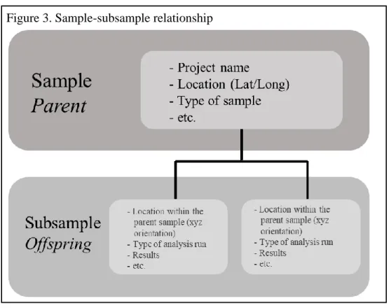
The materials in Table 1 are physical objects and scientific samples. They may
collectively represent a single object or a set of objects. For example, rock cuttings are materials from below the surface which are collected at intervals from a drill rig. As the rig drills below the surface, the driller will capture a selection of materials returned from the drill bit and record the interval below the surface they were taken. The complete set of rock cuttings includes the series of sample bags from each of the intervals collected. This set is referred to as a sample, while the individual intervals are subsamples. Alternatively, someone may also take material from a specific interval for analysis, and this would also be a subsample. The relationship between sample and subsample is hierarchical. The information about the parent (the set of cuttings) is also assumed by the subsample, or offspring (see Figure 3). For example, the
30
considered properties of the parent. When searching for samples, researchers may be looking for information related to the parent or the offspring.
Representation of knowledge.
Knowledge generation is important and is reliant on a number of things; however, not everyone has the same framework for understanding knowledge. Much of the information related to tacit knowledge is hard to communicate, “It is assumed that users of geological maps have in common a geological training and background that enables them to interpret the implicit information, but even with such a shared background, there is much room for misinterpretation and misunderstanding” (Loudon & Laxton, 2007, p.331). Particularly in technological systems, one might need more context and provenance to understand where the knowledge is coming from. These systems should “ensure all data and knowledge is recorded using common, documented standards to promote wider interoperability, and data and knowledge exchange” (Howard et al., 2009, p. 825).
31
In the earth sciences, frame of reference makes an important difference. Knowing the location where a marble was collected tells us different information (contextually and scientifically) about its geological history. Additionally, the point of view of the original
researcher can affect data; for example, if knowledge is created or used by a petroleum geologist versus a civil engineer. Additional information is needed to create a common background and understanding of how the knowledge should be interpreted and how it might be applied.
According to Loudon and Laxton (2007), knowledge can be generated based on predetermined procedures and/or “more flexible, holistic” procedures when conducting geological field work (p. 321). To capture these steps, the specific provenance is recorded (or should be) and becomes the metadata used in defining and reconciling information sources. This leads towards the need for a “shared framework and standardized ontologies” to “avoid pointless and unnecessary variation” (Loudon & Laxton, 2007, p. 321). More specifically, Balestro et al. (2013) state there is a need in the earth sciences to “allow sharing and spatially discovering [of] maps, and support [for] interchange of data amongst different systems, experts and communities” (p.254). Given this need for sharing and discovering, one must ask, how are these materials being organized? The organization of these materials impacts search and system design.
Information organization.
As mentioned previously, Earth Science is a very diverse field with a wide variety of subdomains. Each have different uses, perspectives, collection procedures, and publishing processes related to similar geological data. For example, within geology, sedimentary
32
In developing knowledge management frameworks, there are three different types of information, explicit, implicit, and tacit. These are defined in Table 2 in the context of earth science data. Knowledge becomes increasingly difficult to formalize as it progresses from explicit to implicit to tacit. The example above with sedimentary and structural geologists illustrates a mixture of implicit and tacit knowledge. Within a specific organization, a
community of practice may develop where there is a shared understanding of these frameworks and processes. These practices might not be captured explicitly. Frameworks should “ensure knowledge capture is carried out in the context of prior information, i.e., it builds on and augments prior information, without re-inventing it, [to] ensure that the data and knowledge capture process is verifiable, repeatable and auditable” inside and out of a specific organization (Howard et al., 2009, p.826).
Table 2
Three types of knowledge
Explicit
Implicit Tacit
Conventional Digital*
Definition
knowledge that has been recorded, communicated or articulated in some
tangible way
knowledge that has been adequately described in a form
that is machine-process-able
knowledge that is capable of being communicated or articulated, but is yet to
be made explicit
knowledge that cannot be articulated, but is
acquired and exchanged by experience-based learning (rather than
verbal instruction)
Geoscience examples
Textbooks, indexes; Procedure manuals; Papers, reports, map explanations; Maps, sections, diagrams;
Field notes, data files, ephemera; Recorded field or
lab observations/data
Digital 3D and process models; Computer code; Framework, ontologies, metadata;
Embedded in digital field support; Hypertext sequences, workflows; GIS, spatial models; Databases Unrecorded field observations; Trains of
thought supporting models or interpretations
e.g. what data has been considered or ignored,
and why; Certainty/uncertainty re.
observations/models
Experience in analysis – e.g. seismic/petro-physical interpretation;
Spatial judgment –e.g. geology of underground or open
pit mine design
Increasing difficulty to formalize
33
This is particularly important with physical objects where tacit and implicit information must be captured, and in most cases, cannot be determined by conventional methods. Implicit decisions the geologist made when collecting the sample (for example, why that particular piece was selected over another) maybe be lost if not recorded. Once captured, we need to be able to manipulate this information. Howard et al. (2009) state that some “geological information either lies latent in a scientist’s mind or is expressed in a software-specific language, being able to express the semantics of that knowledge in ontologies is critical to support the future of
geological research” particularly “in a grid environment” (p.833). This information is implicit but may include some tacit knowledge as well. Howard et al. (2009) elaborate further by stating:
“An ontology-based future for the World Wide Web will enable greater access to tacit and implicit knowledge in shared geoscience knowledge bases and the wider web community. By automating data discovery and conditioning tasks, ontologies will also help GSOs to unlock and harness the considerable knowledge assets within their traditional paper records and archives. Sustained investment and international collaboration is needed to capture this valuable intellectual capital and to continue development of the cyber-infrastructures required for wider knowledge exchange and exploitation” (p.834).
34
Objects are often treated as surrogates for the geological processes that formed them, and explicit knowledge used as evidence. An example given by Loudon and Laxton (2007) is of siliceous grit overlaying granite. They both constitute the same rock material, but represent different depositional processes. It is important to capture tacit knowledge such as this reasoning behind final outcomes –the “links between objects, processes and interpretations” - in order for data to be reused and shared (Loudon & Laxton, 2007, p. 323). This requires a shared ontology to “connect information to the underlying reasoning” and develop a “semantic interoperability” (Loudon & Laxton, 2007, p. 323).
Why do we keep scientific data collections?
35
been collected, perhaps a scientist might develop new ideas. This reinforces the idea that scientific collections can be used for a wide variety of purposes beyond the original intent. “Against a backdrop of disappearing habitats, species extinctions and the destruction of sites of geological and paleontological significance, the specimens in natural science collections have become [a] nonrenewable resource of vital importance to science and society” (Duckworth, Genoways, & Rose, 1993, p.1).
Lee, Bell, and Sutton (1982) highlight the importance of having voucher specimens in museums. Voucher specimens “physically and permanently document data” and comprise the “reliability, accuracy, and ability to repeat otherwise good research” (Lee, Bell, & Sutton, 1982, p.5, iii). Similar concepts exist in the earth sciences, called type or holotype specimens. These are the single example of a specific taxon which will be used in identifying future specimens, often the first to bear the name when a new taxon is established (Duckworth, Genoways, & Rose, 1993). Yates (1987) supports this by explaining that voucher specimens “insure that
identifications can be verified or changed if necessary and allow historical comparisons to be made by works in the future” (p. 10). Lee et al. (1982) point out two uses for voucher specimens “1) verifying the identity of the organism(s) used in the study, 2) by so doing, ensures that a study which otherwise could not be repeated can be accurately reviewed or reassessed” (p.5).
36
In addition to theoretical purposes, scientific collections exist for many practical reasons. This is supported by the National Resource Council (2002) in relation to geological samples: “old core can produce new knowledge. Existing geoscience data and collections may be viewed both with new eyes and with new technologies” (p. 12). They can provide information for economic or trade purposes, provide insight into the past, help with managing the quality of our environment, and inform stakeholders such as governments or the public on issues relating to food and agriculture, public health and safety and national security. In addition, they may contain materials with specific intrinsic value – priceless objects that cannot be replaced. Collections may also have a number of unanticipated uses. Changes in technology might allow researchers to ask and answer new questions from existing specimens (NSTC, 2009, p. 2). NSTC (2009) builds on this use by providing a list of functions of permanent scientific collection:
A.As ‘vouchers’ from earlier observations or findings.
B.As standards. Some specimens become permanent references that must be retained for future comparison known as ‘Type specimens’.
C.As sources of specimens for biological research, conservation, and food security. D.As repositories for rare objects.
E. Sources of ideas and study specimens for education and training.
F. Some agencies proactively collect samples for future analysis or experimental use in line with their missions. (p. 11)
It is important to maintain collections, not just for new unthought-of research, but to confirm previous work. Jackson (1999) states, “A fundamental tenet in science is the need for viable checking and reproducibility of results. Re-analyses may not be undertaken for some time after the original research, but require preservation of the original material worked on in order to be of any value” (p. 423). As Lane (1996) states, work is “vouchered and documented by the
37
theories, and theories are created based on replicable data. If the data is inaccessible and the theory cannot be replicated, scientific results would be unsubstantiated. “The availability of the data behind experiments helps to insure scientific integrity by keeping the process open to external evaluation” (Heidorn, 2008, p. 286).
The NRC state in their 2003 report, the government’s “first role [in relation to scientific data collections] is as an unbiased national source of science and information” (NRC, 2003, p. 25 [emphasis in original]). These collections represent irreplaceable materials, “some of the sources of these collections are now reclaimed, flooded, or otherwise inaccessible” (NRC, 2002, p.53). The report warns that private-sector sources of the information are often proprietary and not made available to the public. Occasionally, private organizations discontinue their collections because of the significant costs, specifically weighed in relation to the benefits to the individual organization. This is in contrast to the Federal government that serves a larger population where, “from society’s perspective the aggregate benefits would justify the costs” (NRC, 2003, p. 25). In addition to Federal organizations, there are a number of state agencies such as state geological surveys which “play an important role in generating and disseminating information related to mineral resources” (NRC, 2003, p.25).
Scientific collections of information
38
Group on Scientific Collections (2009) related to object based scientific collections; the
GMRWG (2015) – specific to collections of geological samples; and Cragin and Shankar’s (2006)
definition of scientific data collections (SDC). The NSTC’s description focuses on the
management of physical object based collections - specifically preservation and cataloging for long term access such as research. Specific items are excluded from scientific collections; they “do not include art or historical objects, collectibles, or the books and documents that are stored in libraries and archives. The specimens in scientific collections were acquired as objects for scientific study, not for their aesthetic or market value as collectibles” (NSTC, 2013, p. 11). This is echoed by the GMRWG (2015), which views digital sources as a different collection and is not addressed in their report; instead they focus on physical collections, specifically repositories. “Historically, the term “repository” is indicative of a distinct physical location where samples or documents are housed and curated” (GMRWG, 2015, p.6).
Cragin and Shankar (2006) suggest, “SDCs may include data (raw and processed), metadata, annotation and other supplemental information, visualization and analysis tools, links to other knowledge bases, bibliographic data, etc.” (p.186). While documents and books do typically reside in libraries and archives, these items may also include important metadata which is needed to document scientific collections and the connection between the collection and the library or archive is not clearly defined. This may include implicit information which needs to be explicitly documented for physical objects to facilitate search and discovery. Further research is needed to identify where the distinctions typically appear within organizations when these facilities (libraries and archives) are maintained separately.
39
they broadly define material collections as “a set of specimens that have been brought together on the basis of some common characteristic” (GMRWG, 2015, p.12). This is then detailed as a hierarchy consisting of 5 levels, as seen in Figure 4. At the center is the individual sample. Multiple samples are gathered for a field collection. Field collections from similar “disciplinary, temporal, or geographic parameters” are aggregated as research collections (p. 12). Directed research collections may contain selected samples from various field collections. At the top level of the hierarchy are general collections which “exhibit similarities of sample type or geography” (p. 12).
40
(2006). These scale like variations in data collections are often simplified as small and big data. These collections serve a wide variety of needs both from a creator and a user perspective.
The GMRWG (2015) takes a different view on repositories, with three categories related to the level of curation or long term planning associated with the collections: 1) active repositories – “a permanent facility that assumes responsibility for the long-term storage and maintenance of a collection (or collections) of related materials”; 2) ephemeral repositories – smaller, temporary collections which “allow ready access to samples during the course of research”; and 3) inactive repository – where materials are stored but “neither curator nor management plan exists” (pp. 11). The structure and role of state geological surveys’ collections vary from state to state and may represent any of these levels, if not all.
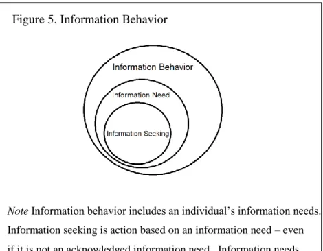
Information behavior
In the previous sections we identified information in the Earth Sciences, discussed the importance of reuse of existing materials, and reviewed how these collections are organized. Building upon these concepts, we now turn to the behavior of users of these materials. When introducing the concept of information behavior, McCreadie and Rice (2002) define four basic terms: 1) Information, 2) Information need, 3) Information seeking, and 4) Information behavior. Information is defined as “any difference perceived in your environment or within yourself”; information need is a “recognition that your knowledge is inadequate to satisfy a goal”;
information seeking “is a conscious effort to acquire information in response to a need or gap in your knowledge”; and information behavior “encompasses information seeking as well as the totality of other unintentional or passive behaviors that do not involve information seeking, such as avoiding information” (Case, 2002, p.5). Figure 5 is a visual representation of the relationship between information behavior, information need, and information seeking based on the