Automatic Terminal Information System for El Alto Airport
N. I. Vargas-Cuentas1, A. Román-González2 1Escuela Militar de Ingeniería, La Paz, Bolivia
2Universidad de Ciencias y Humanidades - UCH, Lima, Peru natalia.i.vargascuentas@ieee.org
avid.roman-gonzalez@ieee.org
ABSTRACT:The air traffic controllers of the El Alto airport must give to the landing and taking off aircrafts, necessary information such as the visibility of the runway, the wind speed and direction, cloud cover, temperature, pressure, etc. This information called Meteorological Terminal Aviation Routine Weather Report (METAR) is essential for taking decision respect to the landing procedure. At aerodromes with a considerable level of traffic, the METAR issue has become a problem, may cause congestion of the communication frequency, this has caused aviation incidents; otherwise the operations are delayed and are not as smooth and efficient on the airfield. The air traffic controller is responsible for issuing the current weather conditions, for this task, the manager of the garden weather must copy the collected data and make a report to communicate the weather condition at the moment, but he takes the report every hour. In summary, there are two main problems; the first is that one provide weather reports that are not of the moment, which can produce aircraft incidents, and finally there is a congested communication frequency, for this reason, the operations are not optimal and fluid. The aim of this work is to implement the ATIS (Automatic Terminal Information System) for El Alto airport.
Keywords:ATIS, METAR, El Alto airport, Text synthesizer, Air traffic
Received: 11 June 2015, Revised 13 July 2015, Accepted 20 July 2015
© 2015 DLINE. All Rights Reserved
1. Introduction
IN El Alto airport, the air traffic controllers must perform daily work giving to landing and taking off aircrafts, necessary information such as the visibility of the track, the wind speed and direction, cloud cover, temperature, pressure, etc.
This information is known as METAR (Meteorological Terminal Aviation Routine Weather Report) is essential to take decisions regarding the landing procedure to be applied or the runway to be used. While the METAR is routine information, it is critical for pilots, for controller, for the performance of the aircraft, and for airfield safety.
The air traffic controller is responsible for issuing the current weather conditions, for this task, the manager of the garden weather must copy the collected data and make a report to communicate the weather condition at the moment., but he produces the report every hour, unless a change in climatic conditions is significant, this is not advisable, since the data of the intensity and direction of the wind, pressure and current temperature, are used to calculate the payload of the aircraft and also to calculate the speeds that the aircraft can achieve in flight. In summary, there are two main problems: the first one is that the weather reports for pilots are not at the time, which can produce aviation incidents, since as mentioned above, the meteorological data influencing on the performance of the airplane. The second problem is related to the frequency congestion, which causes that operations are not optimal and fluid.
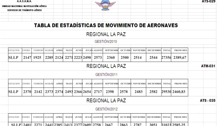
As diagnostic data, statistics of three recent successive administrations were obtained; these data are from the Operation Department of AASANA from different documents such as the statistical bulletin of air navigation services, and the Directory of Air Traffic Services (ATS). In these documents, one found the information shown in Table 1. In summary and as can be seen from the obtained data, the number of aircraft that are received at the aerodrome of La Paz have increased, from 2329.67 aircraft per month in 2010 to 2460.83 aircraft per month in 2011 and 2585.25 aircraft per month in 2012. According to the statistics, we can say that the work of air traffic controllers has increased and currently they must dictate the METAR to an average of 85 aircraft or more per day. In Table 2, we can see the distribution of frequencies in the El Alto airport.
In the data from the frequency table of La Paz can be seen that there are three units or blocks highlighted, these represent the units responsible for providing METAR reports orally, these dependencies are: Aerodrome Control Tower (TWR) with an assigned frequency of 118.30 MHz and one available channel; the Approach Control (APP) with a frequency of 119.50 MHz and one available channel; and finally the Terminal Control Area (TMA) with a frequency of 123.90 MHz and a single available channel. Usually the last one does not provide weather reports, but if it is necessary, it will do.
At the El Alto airport, there are only two frequencies, the frequency of APP and the frequency of TWR, and two controllers with their respective relays that provide METAR reports. These two controllers are: the Tower (TWR) controller that is in charge of the aerodrome traffic and controls aircraft runway, landing and takeoff; and another Approach (APP) controller that controls the arrivals and departures of aircraft, also controls lower-level air routes and provide radar service. Then the air traffic controllers in addition to their assigned functions, they must give the METAR reports, and this makes a congestion of the two frequencies available at the El Alto airport, and operations are smooth and with little delay.
Figure 1 shows a list of incidents and accidents raised in 2012. One can see in the statistics that the heavenly bars mean the incidents at the airport in the city of La Paz and every month there have been several incidents, they occur by congestion of the frequency and misunderstanding of instruction given by the controller; they can also occur due to mechanical failure.
The continuation of this article is organized as follows: Section II shows the general concepts of the METAR report. In Section III, the description of an ATIS system is mentioned. Section IV describes methods for speech synthesis. In Section V prototype development arose. Finally in Section VI our conclusions will be presented.
2. Metar Report
According to ICAO (International Civil Aviation Organization), METAR is the acronym corresponding to the Meteorological Terminal Aviation Routine Weather Report).
José María Gacias (2008) said that the METAR is a report that provides the prevailing weather at a particular airport at a given time. The data are obtained from the local meteorological station located at the airport (p.1).
At annex 3 of ICAO – Meteorological Service for International Area Navigation (2011) is established data that must contain a METAR report: Report type, ICAO identifier, date and hour, wind, visibility / RVR (runway visual range), relevant atmospheric phenomena, clouds, ambient temperature and dew point (relative humidity), and altimeter setting.
2.1 METAR Format:
ESTACION ENERO FEBRERO MARZO APRIL MAYO JUNIO JULIO AGOSTO SEPTIEMBR OCTUBRE NOVIEMRE DICIEMBRE TOTAL PROM-MES
SLLP 2147 1925 2285 2124 2271 2223 2490 2573 2360 2500 2514 2544 27356 2389,67
SLLP 2370 2142 2373 2374 2493 2366 2654 2717 2398 2578 2483 2582 29530 2460,83
SLLP 2401 2271 2441 2385 2413 2377 2609 2758 2667 2863 2787 3051 31023 2585,25 ESTACION ENERO FEBRERO MARZO APRIL MAYO JUNIO JULIO AGOSTO SEPTIEMBR OCTUBRE NOVIEMRE DICIEMBRE TOTAL PROM-MES
ESTACION ENERO FEBRERO MARZO APRIL MAYO JUNIO JULIO AGOSTO SEPTIEMBR OCTUBRE NOVIEMRE DICIEMBRE TOTAL PROM-MES
Table 1. Statistics table of aircraft traffic Source: Directory of Ais Traffic Service, 2012, ATS-029, ATM-031, ATS-035
METAR SLLP 121700z 21016G24KT 180V240 1500 R10/ 600M RA BR BKN 015 OVC025 06/04 Q1005.
A part by part description of the METAR report is follow:
- METAR: Report type indicator, which in this case is a routine METAR weather report. The report could also be a SPECI report that is not routine, a TAF report that is forecasting a SIGMET or AIRMETs report that are weather reports that are granted in flight and which contain relevant information for pilots.
Graphic 1. Statistical graphics of aircraft movement. Source: Directory of Ais Traffic Service. (2012, ATS-061)
- SLLP: ICAO identifier of the station, in this case is the El Alto International Airport, where S indicates that the aerodrome is located in South America, L indicates that the aerodrome is located in Bolivia and LP is the indicator of the city, in this case La Paz.
- 121700z: The date and time, the first two digits (12) indicate the date, followed by the Zulu or UTC (1700z) time, it is necessary to say that the Zulu time is ahead by 4 hours with respect to the time in Bolivia.
digits indicate the speed in knots at which the wind is blowing (16), the letter G indicates that winds are gusts and the last two digits indicate the highest gust in knots (24KT).
- 180V240: Indicator of the variation degree of the wind, the first three digits indicate, in degrees, the minimum variation of the wind (180) and the last three digits indicate, in degrees, the maximum variation of the wind (240), the letter V indicates that the data is a range of variation
- 1500: Indicator of horizontal visibility in meters, in this case it has a visibility of 1500 meters. If it has a value of 9999 means it has a higher visibility than 10Km
- R10/ 600M: Indicator of the runway visual range (RVR), the letter R indicates the identifier of the runway; in this case the runway 10 from El Alto airport, the following value indicates the visual range, in this case 600 meters, worth mentioning that if the value was followed by Ft letters, the value is measured in feet. When the visual range is a variable range, will have to be the minimum and maximum values have the letter V in the middle, for example 600V800.
- RA BR: Indicator of current climatological conditions on the airfield, RA notes that on this occasion we have rain at the airport, on the other hand, BR indicates that we have brume.
- BKN 015 OVC025: Indicator of amount of clouds, and sky coverage, BKN 015 indicates that there are broken clouds at 015 hundred feet from the ground; OVC025 indicates that the sky is covered with 025 hundred feet above the ground
- 06/04: Indicator of the temperature and dew point, the first two digits (06) indicate the temperature in Celsius degrees, the other two digits (04) indicate the relative humidity of the air.
- Q1005: Indicator of atmospheric pressure, if the value is preceded by the letter Q, the value is measured in units of hecto-pascals, on the other hand if the value is preceded by the letter M, then the value is measured in inches of mercury. In this case, we have a corrected atmospheric pressure or QNH of 1005 hecto-pascals (hPa).
3. ATIS System
According to the DGCA (General Directorate of Civil Aviation), ATIS is the acronym for Automatic Terminal Information Service, and it is a continuous information broadcast in congested terminal areas. The ATIS contains essential information such as weather information, which runways are operational, available approaches, and any other information that pilots may need. Normally the pilot hears the ATIS before contacting the local controller. The primary mission of ATIS is to remove the workload for controllers (ATM/01/03, 2011).
The document (2011)-Air Traffic Management says that: ATIS is the continuous broadcast recorded on a selected area of great activity. Its aim is to improve the effectiveness of the controller and alleviate congestion from the often repetitive and automated transmission of the most essential information. The information is continuously transmitted from a differential VHF radio frequency or by a local radio navigation voice (p. 4-8).
According to the RAP 311 (2011), the requirements for ATIS system are:
• The communicated information must be only from one airdrome.
• The information provided will be updated immediately after a significant change.
• The preparation and transmission of the ATIS message will be in charge of the air traffic services.
• Each ATIS message is identified by a designator in the form of a letter of the ICAO phonetic alphabet. The assigned designator for consecutive ATIS messages must be in alphabetical order.
adequate, and the identification signal of navigation aids is inserted into the broadcast without masking.
• The ATIS broadcast should not be transmitted on the voice channel of the ILS.
• When it is possible, the message of the vocal ATIS broadcasts shall not exceed 120 seconds, additional information will be included only when exceptional circumstances warrant.
• The distance to be covered by the ATIS transmission system must be at least 120 km.
• Aircraft shall acknowledge receipt of the information to establish communication with the ATS unit that provides the approach control service or with the aerodrome control tower.
• The weather information is extracted from the local regular or special weather report.
4. Interfaces for Data Collection and Text to Speech Synthesizing
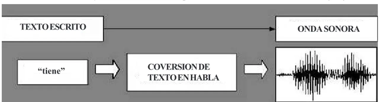
According to the Technological Observatory of Spanish Ministry of Education (2013), speech synthesis, also known as Text to Speech Conversion (CTV), is a process that provides to the system the ability to convert a given text into speech. This task can be done by earlier recordings made by people.
TEXTO ESCRITO
“tiene” COVERSION DE
TEXTO EN HABLA
ONDA SONORA
Figure 1. Converting text to speech (CTV). Spanish Technological Observatory, (2013, p.1.)
The computer voice can be generated combining recordings that have been made, whether, whole words or phonemes, but always trying to get that the produced sound look as natural as possible and intelligible, concatenating the sounds within the discourse correctly. In addition, the system must be able to synthesize any random text, not one set by default.
According to the Technological Observatory of Spanish Ministry of Education (2013), there are two ways to perform this synthesis:
- Concatenative Synthesis: Concatenative synthesis is based on the union of segments of recorded voice. This method produces a more natural synthesis and has no mathematical model. There are three methods for concatenative synthesis; the first one is called synthesis by unit selection that uses a database where voice recordings are: phonemes, syllables, words, phrases, and sentences. This method produces a more natural sound, but these databases can reach a very large size. On the other hand, there is a synthesis by diphones using a minimum database in which we have saved an attached example of diphones (in Spanish there are approximately 800 different diphones), but this method produces a robotic voice, so it is obsolete. Another method of concatenative synthesis is the specific synthesis for a domain that binds words and phrases to create complete outputs. This method is used for very limited areas.
Normalizaction del texto de entrada
Coversion
fonetica Application de prosodia
Generaction de sonidos
post procesameinto
del audio
Figure 2. Phases of the text to speech synthesis. Standardization of the input text for a speech synthesis system (2012, p.7.).
5. ATIS System Prototype Design
The voice synthesizer method used for this work is the synthesis by concatenation.
For the final design of the prototype ATIS system, we have the following considerations:
- The meteorological report to be transmitted by the system must contain twenty information blocks about current conditions at the aerodrome, the meteorological conditions and supplementary information.
- The report data must be transmitted adhering aeronautical radiotelephone communication techniques.
- The system must have a database that includes numbers, letters, speeches, conjunctions and units used in aviation - The program must be able to respect the constraints presented by the METAR report data.
- The system must be able to separate and distinguish each information block held in the METAR.
- The weather information will come with the file format needed for reading, also additional information, pretending to come from the Meteorology Department.
The first step taken to program the speech synthesizer was to identify the current weather report, simulating that the files arrive at a folder. For this task, we have the following code.
% Reading the METAR
Files = dir(‘METAR’);
[C, I] = max([Files(3:end).datenum]);
METAR = importdata([‘METAR/’ Files(I+2).name]);
The above statement collects the files that exist in the METAR folder by datenum parameter, which indicates the creation date of the file, but expressed as a number, so the more recent file will be represented by the highest number, it is why the max
instruction is used, to always read the last file. On the other hand, the number 3 in the instruction is due to auxiliary files existing in the folder, which is not taken into account, so we should read starting in number three from the most recent files.
As a second step we proceeded to identify the size of the METAR report and proceeded to divide the information blocks using the code below:
% Size of METAR
[l c] = size(METAR{1});
r = 1; s = 0;
for i=1:c
if isspace(METAR{1}(i)) T(r) = s;
r = r+1; s = 0;
else
REPORT(r,s+1) = METAR{1}(i); s = s+1;
end end
T(r) = s; REPORT
In the above statement, the size vector “l” is the maximum value, and “c” is the position to identify the size of the METAR, then in reading the weather report blocks, we have “r” that it is the block information that is reading, and “s” is the number of digits for this block, also the function is given a space on each block to differentiate
The next step taken was to establish rules of oral reading of meteorological data for each block, as example, we show the reading block for wind grades and speed, for this block we have the following code:
function AUDIO = Repr_Viento(REPORT,T,Alocuciones,Conjunciones,Numeros,Unidades)
P = zeros([22050 2]); A1 = Alocuciones{7}; A2 = Conjunciones{7};
AUDIO = [A1; A2];
for i=1:3
n = str2num(REPORT(i));
AUDIO = [AUDIO; Numeros{n+1}];
end
AUDIO = [AUDIO; Unidades{1}];
for i=5:T-2
n = str2num(REPORT(i));
AUDIO = [AUDIO; Numeros{n+1}];
end
The developed program was tested, and we have a proper operation for synthesis each information block of the weather report. Also as shown in Figure 3 of the example tested in MATLAB, the program was able to split the data into blocks and also was tested identifyng the number of digits for each block.
6. Conclusions
• The identification of the shortcomings of the oral transmission of METAR envisioned that in addition to a delay in the transmission there is also a suppression of the weather report information.
• The estimation of the current situation of the air traffic controllers with respect to the oral transmission of METAR report, allowed quantifying the study variables of this project, such as the transmission time of the report, the number of repetitions per aircraft, the time for report updating, and the timeout of an aircraft for waiting the METAR
• The recognition of the elements available at the El Alto airport that were used to develop the prototype allowed that the developed ATIS system is capable of adapting the resources available at the aerodrome without external equipments.
• The design of the ATIS system prototype identified the information to be transmitted by the system, the radiotelephone techniques used for this, the system synchronization with a time server, and the identification of the detailed operation of the ATIS system.
• The development of the program allowed us to identify the type of voice synthesis system, the concatenative synthesis was used, because it gives a more natural voice and a little extensive database. On the other hand, our database was optimized to shorten the time required for reproduction of the METAR report.
In the previous statement, in the first instance we have the database needed for quick reading this information data block, as had been previously identified, then for reading this block, certain numbers, units, addresses and conjunctions are required.
Then it gets a pause for an understandable reading and then proceeds to read the data number to the number of degrees and wind speed. The first instruction “for” identifies the wind grades, starting at the first digit, the degree of wind can have only up to three digits.
On the other hand, the second “for” statement identifies the wind speed, begins in the fifth digit because the fourth digit is the unit of wind and grades should not be taken into account because it is not a numeric value, and ending with the digit “T-2” because the last two digits represent the block units and no numeric values.
Was performed a program for each information blocks which are 13.
Finally we proceeded to test the program to observe proper operation, and obtained the following result:
• The design of the synthesized data transmission by the VOR (VHF Omnidirectional Range) allowed to identify that the absence of a discrete VHF frequency at the aerodrome, and radio aid could cover the requirements of the working frequency and coverage area required by the ATIS system.
• The development and implementation of the ATIS system reduced the time spent for dictating the METAR, weather update to register a change in the airport data, decongest the communication frequencies between pilots and controllers, and improve operations at the aerodrome.
References
[1] AASANA (Administración de Aeropuertos y Servicios Auxiliares a la Navegación Aérea). (2012a). Anuario del Servicio de Tránsito Aéreo (ATS). Bolivia: Author.
[2] AASANA (Administración de Aeropuertos y Servicios Auxiliares a la Navegación Aérea). (2012b). Boletín Estadístico de Servicio de Navegación. Bolivia: Author.
[3] AASANA (Administración de Aeropuertos y Servicios Auxiliares a la Navegación Aérea). (2012c). Publicación de Información Aeronáutica (AIP). Bolivia: Author.
[4] AASANA (Administración de Aeropuertos y Servicios Auxiliares a la Navegación Aérea). (2011d). Servicios Meteorológicos para la Navegación Internacional. Bolivia: Author.
[5] AASANA - CNS (Comunicación Navegación y Vigilancia). (2010). Plan de Acción para las Mejoras de los Sistemas de Comunicación. Bolivia: Author.
[6] Cejudo, P. (2010). Gestión Aeronáutica y Aeroportuaria. España: Universidad San Pablo (CEU). [7] Chávez Rimort, (2013). Control de Tráfico Aéreo, Bolivia: INAC (Instituto Nacional de Aviación Civil).
[8] DGAC (Dirección General de Aeronáutica Civil), (2011a) ATM/01/03 (Manual de Procedimientos para los Servicios de Tránsito Aéreo, V.01, Apéndice 03). Bolivia: Author.
[9] DGAC (Dirección General de Aeronáutica Civil), (2011b) DOC. 4444 (Gestión del Tránsito Aéreo). Bolivia: Author.
[10] DGAC (Dirección General de Aeronáutica Civil), (2011c) RAB – 69 (Reglamentación Aeronáutica Boliviana V.69). Bolivia: Author.
[11] DGAC (Dirección General de Aeronáutica Civil), (2011d) RAP – 311 (Reglamentación Aeronáutica). Bolivia: Author. [12] Entrevista con Juan Columba Cossío. (2013). [Supervisor de Tránsito Aéreo del Aeropuerto de El Alto, Control de tráfico Aéreo].
[13] Gacias José María. (2008). Reporte Rutinario de Clima para la Aviación METAR, Bolivia: INAC (Instituto Nacional de Aviación Civil).
[14] Grupo de Tecnología del Habla. (2010). Tecnologías del habla. Red Iberoamericana de Colaboración Universitaria. Anexo 1, 22-29.
[15] LumenVox, (2013). Características del Servidor de Texto a 22 [folleto]. California: Central Regional de la Empresa Privada de Software de Reconocimiento del Habla LumenVox.
[16] OACI (Organización Aeronáutica Civil Internacional). (2011a). Anexo 2 – Reglamento del Aire. EE.UU: Author.
[17] OACI (Organización Aeronáutica Civil Internacional). (2011b). Anexo 3 – Servicio Meteorológico para la Navegación Aérea Internacional. EE.UU: Author.
[18] OACI (Organización Aeronáutica Civil Internacional). (2011c). Anexo 10 – Telecomunicaciones Aeronáuticas. EE.UU: Author.
[22] Pool G. (2010). Síntesis y Reconocimiento de Voz. México: Centro de Investigación Científica de Yucatán.
[23] Quintana A. (2011). Manual de fraseología Pilotos/Controladores. Bolivia: INAC (Instituto Nacional de Aviación Civil). [24] UNIVERSIA, (2012). Definición y tipo de entrevistas. Red Iberoamericana de Colaboración Universitaria, 348, 8-9. [25] Universidad de Madrid (2012). Estadística básica. Red Iberoamericana de Colaboración Universitaria, 23.