UNIVERSITY OF NORTH CAROLINA – CHAPEL HILL
Pedal to the Metal
Bicycle-transit integration in San Francisco: Existing
conditions, needs, and recommendations for Polk
Street
Terra M. Curtis
1
Executive Summary
What is bicycle-transit integration?
“Integration” encompasses the physical as well as conceptual marriage of bicycling and transit in San Francisco. To be integrated means to have bicycling and transit networks and policies that encourage, rather than discourage, each other’s use.
Purpose and Vision
This study aimed to examine bicycle-transit integration in San Francisco. It had two purposes:
1) To provide a framework and initial background information for a citywide San Francisco Municipal Transportation Agency (SFMTA) bicycle-transit integration plan;
2) To study the Polk Street corridor and recommend bicycle-transit integration strategies.
In order to guide the study of Polk Street, a draft vision statement, goals, and objectives for the SFMTA’s citywide plan was established.
Vision Statement: A San Francisco that enables residents to access destinations by bicycle and transit comfortably, conveniently, safely, and efficiently.
Motivations
Several factors motivated this study. First, San Francisco has adopted ambitious goals for bicycle and transit use. By 2020, the city aims to have 20 percent of trips made by bicycle. By 2035, 40 percent of trips should be made by bicycling and walking combined. On the transit side, by 2035, 30 percent of trips should be made by transit. Additionally, the city has a long-standing Transit First policy, which presents transit, bicycling, and walking as attractive alternatives to the private automobile. It encourages bicycling specifically as an access mode to transit and suggests bicycle lanes, bicycle parking, and innovative solutions to encouraging transit use in promoting overall safe and efficient movement in the city.
Second, a 2011 customer satisfaction survey revealed two top reasons why people do not ride Muni more often: the need to travel more quickly and high waiting times. Bicycle-transit integration can address these concerns directly.
Goals and Objectives
This study was guided by four goals and their associated objectives. These goals and objectives may be refined at a later date for the citywide bicycle-transit integration plan with guidance from the Technical Advisory Committee (TAC), which was established in March 2012. These four goals are:
(1) Improve bicyclist and pedestrian safety near transit
(2) Alleviate passenger loads on crowded Muni lines by converting some transit trips to bicycle trips
(3) Increase bicycle and transit mode share (4) Prioritize transit reliability
Each goal was tied to several objectives – more specific aims that guided this study and the resulting recommendations. These objectives can be found in the Introduction.
Process
A literature review of current practices, academic research, and design guidance from the U.S. and abroad revealed four main bicycle-transit integration strategies: bicycle parking, bicycles-on-transit, on-street enhancements, and bicycle sharing systems. With these in mind, existing citywide bicycle and transit plans, policies, and projects were documented and existing conditions on Polk Street were reviewed. A narrative of Polk Street was developed in the Existing Conditions report and Needs Assessment section, which was used to highlight the corridor-specific existing conditions that hinder the achievement of goals (1) – (4). The four strategies identified in the Literature review were applied to these needs in order to create a set of programmatic and infrastructural recommendations. Recommendations were presented in two categories: Ideal (unconstrained proposals) and Critical (must-have proposals).
Existing Conditions
3
Recommendations
As noted previously, two sets of recommendations were made. The first is visionary and based on an unconstrained view of Polk Street; the aim was to envision an exemplary bicycle-transit integrated corridor as if it were being created from scratch. These recommendations include removal of on-street parking in some sections and installation of separated cycle tracks along Polk Street. The second set, “critical” recommendations, weighted existing constraints more heavily and proposed investments that are critical to the success of the city’s many bicycle and transit goals. These include demarcating bicycle space on Polk Street and maintaining on-street parking.
Acknowledgements
This work would not have been possible without the encouragement, guidance, and contributions of many colleagues, friends, and family.
First, I would like to thank Daniel Rodriguez, my advisor in the Department of City & Regional Planning, who always provides a warm welcome, thoughtful feedback, and encouraging words.
My colleagues at the San Francisco Municipal Transportation Agency are invaluable resources. Nate Chanchareon, under whose guidance this project was initiated, is a tireless advocate for his staff and their ideas. My direct supervisor for this project at the SFMTA was Andrew Lee, who has an uncanny ability to make clear, forward-thinking suggestions. I’d also like to thank Timothy Papandreou, who dreamt up this idea (and who continues to dream big); Peter Brown, who helped with everything from word choice to logic to seeing the big picture; and Mari Hunter and Grace Lin, who provided useful feedback and helped track down the necessary data. Several others also contributed by promptly answering my many, many unsolicited emails. Thank you.
One small but incredibly important piece of this puzzle was contributed by Elizabeth Sall of the San Francisco County Transportation Authority. Thank you for your determination!
To my classmates: thank you for your inspiration and camaraderie. It has been a true pleasure to work and surround myself with such motivated, intelligent, and poised people. I hope to find even half as much an encouraging environment in the future.
5
Table of Contents
1. Introduction ... 1
2. Existing Conditions ... 4
3. Polk Street ... 28
4. Needs Assessment ... 44
5. Literature and current practice review ... 50
6. Recommendations ... 61
7. Funding Opportunities ... 70
8. References ... 71
9. Appendix A – Model practices for bicycle-transit integration in San Francisco ... 77
10. Appendix B – Design guidelines ... 80
11. Appendix C – 19-Polk Ridership ... 85
12. Appendix D – TEP Bicycle Projects ... 88
13. Appendix E – Detailed Existing Conditions ... 90
14. Appendix F – Transit First Policy ... 94
List of Figures
Figure 1 - ThinkBike concepts for Polk Street (SFMTA, personal communication) ... 10
Figure 2 - Connecting the City vision for Polk Street; created by Woods-Bagot (SFBC, 2012) . 11 Figure 3 - Bicycle and transit networks, bicycle parking, and bicycle counts ... 19
Figure 4 - SFMTA Bicycle parking and network map ... 20
Figure 5 - SF Planning Transit Corridors map... 21
Figure 6 - Transit crowding as of October 2011 and bicycle count locations ... 22
Figure 7 - Age distribution in San Francisco ... 23
Figure 8 - Income distribution in San Francisco ... 24
Figure 9 - Bicycle commuting in San Francisco ... 25
Figure 10 - Transit commuting in San Francisco... 26
Figure 11 - Residential density in San Francisco ... 27
Figure 12 - Polk Street existing bicycle parking and bicycle network connections ... 29
Figure 13 - Northern Polk Street Segment ... 30
Figure 14 - Northern Polk Street driveways (image credit: Terra Curtis) ... 30
Figure 15 - School-time pedestrian traffic, Polk at Bay Street (image credit: Terra Curtis) ... 31
Figure 16 - Northern Polk Collisions ... 32
Figure 17 - Central Polk Street Segment ... 33
Figure 18 - Sharrows along Central Polk (image credit: Terra Curtis) ... 34
Figure 19 - Bus stops and sharrows on Polk at Sutter (image credit: Terra Curtis) ... 34
Figure 20 - Bus stops blocking most of vehicle and bicycle travel lane, Polk at Pine St (image credit: Terra Curtis)... 34
Figure 21 - Bicycle lane and parking lane overlap, Polk between Ellis and O'Farrell (image credit: Terra Curtis)... 35
Figure 22 - Central Polk Collisions ... 36
Figure 23 - Southern Polk Street Segment ... 38
Figure 24 - The constrained Polk Street right-of-way opens up here, looking south to Dr. Carlton B. Goodlett Place (image credit: Terra Curtis) ... 39
Figure 25 - Existing southbound bicycle lane on southern Polk Street (image credit: Terra Curtis) ... 39
7
List of Tables
Table 1 – Van Ness BRT goals’ alignment with bicycle-transit integration ... 8
Table 2 – Summary of recommendations and needs from Citywide plans and projects ... 12
Table 3 – Citywide statistics related to bicycle-transit integration goals ... 15
Table 5 - Trips by mode, 2011 and 2035 ... 16
Table 4 – Map catalog... 17
Table 6 – 19-Polk on-time performance ... 42
Table 7 – Corridor and neighborhood needs ... 44
Table 8 – Point and station needs ... 46
Table 9 – Citywide needs ... 48
Table 10 - International strategies to reduce transit-bicycle-pedestrian conflict ... 54
Table 11 – Percent of bicycle sharing trips shifted from other modes (Asian cities)* ... 57
Table 12 - Percent of bicycle sharing trips shifted from other modes (European cities)* ... 57
Table 13 - Four main bicycle-transit integration strategies and use case ... 61
Table 14 - Corridor and neighborhood recommendations ... 62
Table 15 - Point and station recommendations ... 64
Table 16 - Citywide engineering recommendations ... 68
Table 17 - Citywide education recommendations ... 68
Table 18 - Citywide enforcement recommendations ... 68
Table 19 - Citywide encouragement recommendations ... 69
Table 20 - Citywide evaluation recommendations ... 69
Table 21 – Funding opportunities ... 70
Table 22 - TEP bicycle-related projects as of January 8, 2012 ... 88
Table 23 - Detailed existing conditions for Polk Street ... 90
List of Acronyms
BART – Bay Area Rapid Transit BRT – Bus Rapid Transit
BSP – Better Streets Plan CAS – Climate Action Strategy CVC – California Vehicle Code LRV – Light rail vehicle
SFBC – San Francisco Bicycle Coalition
1
1.
Introduction
1.1
Background
In 2010, the San FranciscoBoard of Supervisors adopted a goal to reach 20 percent of all trips by bicycle by the year 2020. This aggressive target is in line with the goals of the San Francisco Municipal Transportation Agency’s (SFMTA) 2009 San Francisco Bicycle Plan. The ongoing Transit Effectiveness Project (TEP) of the SFMTA seeks to improve safety, service reliability, and reduce travel time for Muni service. In order to ensure the success of these ongoing projects, San Francisco must increase and enhance its set of alternatives to private automobile use.
In the fall of 2011, the SFMTA applied for and received an $180,000 Safe Routes to Transit (SR2T) planning grant from TransForm. TransForm is administrator of the Metropolitan Transportation Commission’s (MTC) Regional Measure 2 (RM2) funds, monies collected through voter-approved bridge toll increases for congestion mitigation projects (MTC, 2011).
The SR2T grant funds a bicycle-transit integration project to be performed by the SFMTA throughout 2012 and into 2013. The project is intended to identify the needs for bicycle-transit integration on several key corridors and recommend a comprehensive set of policy and capital improvements.
This master’s project contributes to the SFMTA’s overall effort through two main components: a citywide component and a corridor-specific component. Literature, current policy, and adopted plans are reviewed in order to make citywide recommendations where existing conditions limit the potential for San Francisco to achieve its ambitious bicycle and transit mode share goals. The corridor-specific component focuses on one San Francisco corridor to provide capital
improvements recommendations that may serve as examples for the wider city effort.
The vision statement, goals, and objectives listed below are preliminary statements for the overall SFMTA project; they are the guiding principles for the recommendations made in this master’s project.
1.2
Vision, Goals & Objectives
Vision Statement: A San Francisco that enables residents to access destinations by bicycle and transit comfortably, conveniently, safely, and efficiently
Goal 1: Improve bicyclist and pedestrian safety near transit
Objective 1.1: Reduce conflicts between bicycles and transit traveling along the same routes
Objective 1.3: Increase perceived safety of bicycling along transit routes
Objective 1.4: Increase transit operator training opportunities for bus-bicycle interactions
Goal 2: Alleviate congestion on crowded Muni lines by converting some transit trips to bicycle trips
Objective 2.1: Reduce instances of crowding on transit lines within ¼ mile of the bicycle network
Objective 2.2: Increase the number of transit passengers who also make the same origin-destination trip using a bicycle some of the time
Objective 2.3: Market the bicycle sharing program to transit users
Goal 3: Increase bicycle and transit mode share
Objective 3.1: Increase combined bicycle-transit trips
Objective 3.2: Increase secure bicycle parking at major transit hubs and transfer points
Objective 3.3: Increase bicycle parking within ¼ mile of major transit corridors
Objective 3.4: Coordinate with regional transit agencies (BART, Caltrain) and the Transbay Terminal on increasing bicycle access
Goal 4: Prioritize transit reliability
Objective 4.1: Reduce dwell time for passengers with bicycles
Objective 4.2: Reduce transit delays caused by bicyclists sharing right-of-way
1.3
Motivations
3 travel time or in reducing transfers; second, by acting as a substitute for transit when transit trips can safely and comfortably be made instead by bicycle.
Lastly, the 2009 American Community Survey shows the share of work trips taken by transit and bicycle in U.S. cities. San Francisco ranks among the highest in transit mode share for
2.
Existing Conditions
2.1
Citywide plans and projects
Several adopted or ongoing planning efforts in San Francisco relate to this bicycle-transit integration work. Here, a summary of those plans is presented. These documents will be referenced throughout the remainder of the document.
2.1.12009 San Francisco Bicycle Plan
One of eight main goals in the 2009 bicycle plan is to “expand bicycle access to transit and bridges” (SFMTA, 2009). A map overlaying the bicycle and transit networks is provided,1
along with several objectives related to their overlap.
“Ensure that the bicycle route network provides bicycle access to all San Francisco Municipal Transportation Agency (SFMTA) Muni Metro, Bay Area Rapid Transit (BART) and Caltrain stations, ferry terminals and other major transit hubs;”2
“Provide convenient bicycle access and bicycle parking at transit stations;”3
“When improvements are made to the bicycle route network, the impacts to other modes, including pedestrians, transit and motor vehicles, must be taken into consideration and balanced with the overall vision of transportation in the City;”4
“Bicycle improvements should not create negative impacts to transit operations.”5
In addition to these broad objectives, several specific actions are called for. Many of these relate to the goals and objectives of this study. While the implementation status of the bicycle plan’s infrastructure projects is closely tracked by SFMTA staff, this is not so for the non-infrastructure action items.
Conduct a before and after study on the impacts of allowing bicycles in exclusive bus/taxi lanes (Action 1.5)
Create an inventory of locations along the bicycle route network that intersect or run parallel to railroad tracks, and identify appropriate measures to mitigate the impacts of the track crossings to bicyclists (Action 1.17)
5
Work with Planning Department to amend the Planning Code to require building owners to allow tenants to bring their bicycles into buildings unless Class I bicycle parking is provided (Action 2.12)
Create an SFMTA policy that explicitly permits folded bicycles on all SFMTA transit vehicles (Action 3.1) – implemented 5/26/2011 (SFMTA staff, personal communication, June 20, 2011)
Develop a pilot program to provide bicycle access on SFMTA light rail for a trial period that would be monitored for potential future implementation (Action 3.2)
Update the SFMTA’s bicycle accessibility [to transit] guidelines and widely distribute and publicize these guidelines (Action 3.3)
Create an SFMTA policy that allows bicyclists with disabled bicycles to bring them aboard SFMTA transit vehicles, interior space permitting and at the vehicle operator’s discretion, when the SFMTA transit vehicle either does not have bicycle racks or when the racks are full (Action 3.4)
Install bicycle racks on all SFMTA-operated buses, and work with other transit operators with buses operating in San Francisco to install bicycle racks on their bus fleets (Action 3.5)
Work with BART to analyze existing bicycle policies, identify expanded bicycle access times and create a trial program for non-folding bicycle access in both directions on Transbay peak period trains (Action 3.6)
Work with Caltrain to expand bicycle access on its trains and to its San Francisco stations by promoting bicycling to stations and by providing secure bicycle parking at station areas (Action 3.7)
Ensure that all San Francisco transit stations, including the new Transbay Terminal, provide barrier-free bicycle access and state-of-the-art bicycle parking facilities, and work with the California High-Speed Rail Authority to ensure bicycles are
accommodated on its long distance trains (Action 3.8)
Work with San Francisco Bay Area transit operators and the Metropolitan Transportation Commission (MTC) to develop, implement, maintain, expand and enforce improved intermodal bicycle access (Action 3.9)
Promote bicycle parking stations at major transit hubs that provide secure, monitored bicycle parking, bicycle commuter information and bicycle maintenance services (Action 3.10)
Develop an SFMTA bicycle safety workshop for transit vehicle operators and other large fleet-vehicle operators (Action 4.8)
Develop a standardized procedure for reporting bicycle-related incidents with transit vehicles and ensure that this information is readily available to appropriate City staff (Action 5.13)
Since the adoption and partial implementation of the Bicycle Plan, several additional spot, low cost projects have been recommended by the SFMTA to improve upon those initially
recommended. Among these is a proposed contra-flow bicycle lane between Grove and Market Streets where traffic currently runs one-way southbound. This project is included in the
SFMTA’s draft Capital Improvement Plan for 2013/2014.
2.1.2SFMTA’s Transit Effectiveness Project (TEP)
The TEP is an on-going project of the SFMTA. It is the Agency’s first comprehensive review of Muni in a generation, and is informed by public input, technical analysis, and best practices. The project has four main objectives: to improve Muni service reliability; to reduce transit travel time; to improve customer experience; and to improve service effectiveness and efficiency (SFMTA, 2011c).
From these inputs, the TEP developed a list of projects to be implemented by 2017. While on-street bicycle-transit interactions are not explicitly noted in the project’s objectives, some of the pre-2017 TEP projects include changes to the bicycle network. These include projects along 16th Street and Geneva Avenue, with implementation anticipated to begin in late 2013-2014. Some of the projects involve removal of bicycle lanes, particularly along 16th Street, while others involve moving bicycle lanes behind transit stops (e.g. Geneva Avenue).
On 16th Street, the decision to remove the bicycle lane was made due to the fact that not enough room exists for both the planned transit-only lane and a bicycle lane. The 16th Street bicycle lane will be moved to 17th Street. On Geneva Avenue, the decision was made to have a bicycle lane/cycle track run behind the bus boarding islands (creating a “bus bulb plaza”) in order to avoid bus-bicycle conflicts at bus stops. This design has also been proposed for Masonic Avenue (SFMTA, 2011a). See Table 22 in Appendix D for a full list of TEP bicycle-related projects.
2.1.3BART Bicycle Parking and Access Plan
Bay Area Rapid Transit (BART) is currently undergoing an update to its 2002 Bicycle Parking and Access Plan. This work overlaps with SFMTA’s bicycle-transit integration efforts
particularly where BART and the SFMTA share stations. Through several qualitative and quantitative research efforts, BART has identified the following existing conditions:
7 In sum, BART identified the following factors that influence bicycle access to BART stations:
Bicycle parking
On-board bicycle access
Ease of transporting bicycles through stations
Communication
Auto parking charges
First/last mile route characteristics
These factors were used in the development of a Direct Ridership Model, which is a tool to predict transit ridership based on station characteristics (specifically related to bicycles).6
Lastly, in a gap analysis of bicycle access to BART stations, two San Francisco stations were identified as needing on-street improvements: Civic Center and Glen Park.
There is a need to improve bicycle routes on 7th, 8th, Market, and Grove Streets in order to access Civic Center (partially covered in several 2009 Bicycle Plan projects; 7th, 8th, and Grove Streets are not).
There are needs to construct Class II bicycle lanes on Lyell Street, Bosworth Street between Diamond and Rotteck Streets, and Monterey Boulevard on- and off-ramps from San Jose Avenue in order to access the Glen Park station (Project 5-7 in the 2009 Bicycle Plan).
2.1.4Climate Action Strategy
SFMTA’s Climate Action Strategy (CAS) was developed collaboratively between several city departments in 2011. It offers strategies to guide programs and policies to reduce greenhouse gas emissions from the transportation sector. Among other things, the extensive research effort provides facts about and recommendations related to bicycle-transit integration.
Data from the San Francisco County Transportation Authority (SFCTA) demonstrate that the highest origin-destination pairs of auto travel are along some of the SFMTA’s main transit lines. This pattern presents an opportunity to shift some auto trips to transit trips, but only if transit has ample capacity.7
Unfortunately, the transit system has limited available capacity during peak hours. In San
Francisco, the average automobile trip is less than 3 miles in length and the average transit trip is only 3.4 miles; these trips are only slightly longer than the average 2.3 mile bicycle trip.
Therefore, a suggestion is made in the CAS to supplement existing transit capacity by shifting some transit trips to bicycle trips in the peak period. This would make transit and bicycles a new option for some who currently drive, increasing each of their mode shares.
6
Note: This study does not rely on the Direct Ridership Model because the focus is not on Market Street (the corridor shared by BART and SFMTA transit) and other SFMTA transit stations are much smaller in scale and different in character.
The SFMTA’s mode share goals are also noted in the CAS and are consistent with the goals of bicycle-transit integration: by 2020, 20 percent of trips should be made by bicycle and by 2030, 40 percent of trips should be made by bicycling and walking combined.
Related CAS recommendations include:
Complete the implementation of the SFMTA Bicycle Plan (p. 20)
Increase bicycle parking capacity citywide (p. 20)
Enhance modal integration (for example, with a smartphone application that delivers travel information on all available nearby modes including travel time, price, GHGs and emissions) (p. 22)
Implement bicycle sharing (p. 20)
Create student IDs with integrated transit passes (p. 39)
Require higher ratios of bicycle parking in new developments (p. 40)
2.1.5Van Ness Bus Rapid Transit
Van Ness Avenue runs parallel to Polk Street in San Francisco. Since 2008, the SFCTA has been planning and designing a 2-mile bus rapid transit (BRT) route along Van Ness between Lombard and Mission Streets. The 2004 Countywide Transportation Plan called for a BRT feasibility study, which demonstrated the potential for significant transit benefits; this commenced the 2008 planning process (SFCTA, 2011).
Several goals and expected benefits of the project are consistent with the goals of bicycle-transit integration.
Table 1 – Van Ness BRT goals’ alignment with bicycle-transit integration
Van Ness BRT Goals Bicycle-Transit
Integration Goal
Boost transit ridership (increased transit ridership on Van Ness corridor expected)
Goal 3
Improve pedestrian amenities and safety (shorter and safer pedestrian crossings, Audible Pedestrian Countdown signals)
Goal 1
9 Alternative 1: No build
SFMTA Transit routes 47 and 49 and Golden Gate Transit routes 10, 70, 80, 93, and 101 would remain on the corridor
Modest improvements to Van Ness Avenue signals, bus stops, and pavement
Alternative 2: Side-lane BRT with parking
Right-most traffic lane converted to bus-only lane
Private automobiles allowed to cross bus-only lane to reach parking or make right turns
Bus bulbs (providing pedestrian access) provided at all station locations
Alternative 3: Center-lane BRT with right-side boarding and dual medians
Physically-separated bus-only lanes in center of roadway
Stations along right side of vehicles
Alternative 4: Center-lane BRT with left-side boarding and single median
Left-most lanes in both directions converted to bus-only (not physically separated)
Stations located in a center median, boarding on left side of vehicles
2.1.6Geary BRT
In addition to the Van Ness BRT project, San Francisco is also planning a BRT line along Geary Avenue. A feasibility study has been conducted and approved and currently the SFCTA and the SFMTA are carrying out environmental review. The goal is to have service running by 2015. Station locations have not yet been determined; however, the Geary BRT line would intersect with the future Van Ness BRT line.
2.1.7Mobility, Access, and Pricing Study
The SFCTA has led a feasibility study of several congestion pricing schemes in San Francisco. While there are no plans in place to implement such a scheme, the Transportation Authority Board approved the study in December 2010. Therefore, additional study of the concept is being pursued, with a decision on implementation to be made in 2013-2014. The potential pricing scheme could produce an additional funding source for public transit investments and promote both transit and bicycle use by pricing private automobile use.
2.1.8ThinkBike 2011
Figure 1 - ThinkBike concepts for Polk Street (SFMTA, personal communication)
Prior to the event, SFMTA staff prepared a report of existing conditions. One section of the report focuses on Polk Street between Union Street and Broadway. The Polk Street detailed information is provided in the Existing Conditions section of this report.
The recommendations from the group included a vision for Polk Street as a “People Street.” They stressed solutions that would accommodate existing traffic volumes, reduce bicycle-transit and bicycle-auto conflicts, improve pedestrian experience, and enhance transit access. They also noted that Polk Street is scheduled to be repaved in 2013 – an opportunity to implement
recommended improvements.
A few example improvements include a curbside bikeway with separation, intersection
treatments such as bicycle signal heads and tactile warnings for pedestrians crossing bikeways, parklets and public spaces, and bikeways running behind transit stops to reduce bus-bicycle conflicts. Because these would be new facility types in San Francisco, a public outreach campaign was also suggested.
2.1.9Better Streets Plan
11 Figure 2 - Connecting the City vision for Polk
Street; created by Woods-Bagot (SFBC, 2012)
achieving that goal. The document is currently in draft form; when adopted by the SFMTA Board of Directors, it will guide future bicycle investments in San Francisco. Preliminary findings suggest that on-street infrastructure should receive the majority of funding for bicycle investments with supportive funding for programs, policies, and marketing campaigns.
2.1.11Connecting the City
Connecting the City is a conceptual plan
developed by the SFBC (a 12,000+ member non-profit organization) that calls for the
development of 100 miles of separated bikeways in the city. They have proposed three main initial routes: a north-south connector along Polk and Valencia Streets, a bay-to-beach route running east-west along Market Street and through Golden Gate Park, and a Bay Trail bikeway running along the northeastern perimeter of the city. While this document remains a community plan (not an official document of the SFMTA), some of its proposals are being implemented: in spring of 2012, San Francisco’s first parking-protected bikeway will be constructed in Golden Gate Park along John F. Kennedy Drive. In February 2012, the SFBC began a public outreach campaign for separated bikeways along Polk Street. Their online survey can be found here:
http://www.zoomerang.com/Survey/WEB22E7K3JKKVQ (accessed February 22, 2012).
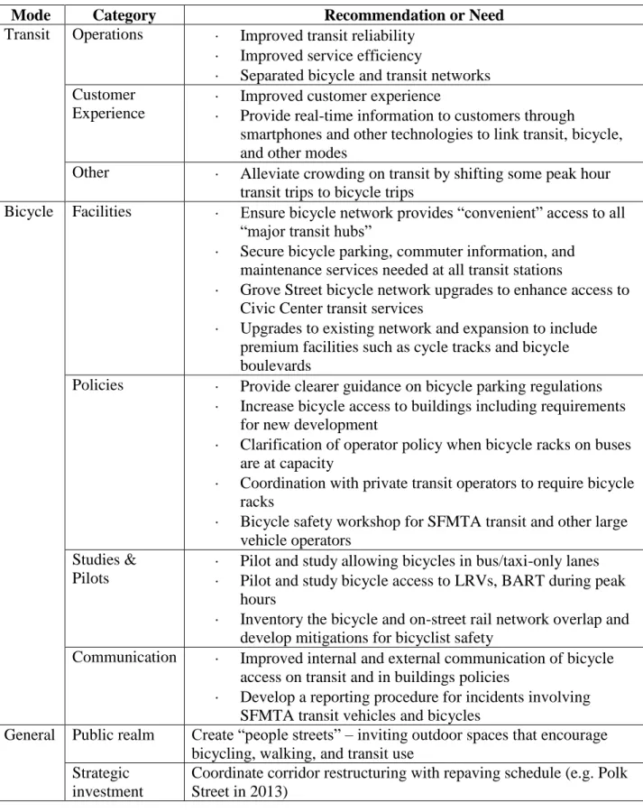
2.1.12Summary of Citywide plans and projects’ implications for Polk Street
Table 2 below provides the key points from the plans and projects described above at the citywide scale. For Polk Street specifically, there are several things to keep in mind. First, the TEP favors separated bicycle and transit networks; the 19-Polk currently shares right-of-way with the only north-south bicycle route in this neighborhood. Second, the city is considering utilizing smartphone applications to improve the usability of the Van Ness BRT and its
Table 2 – Summary of recommendations and needs from Citywide plans and projects
Mode Category Recommendation or Need
Transit Operations Improved transit reliability
Improved service efficiency
Separated bicycle and transit networks Customer
Experience
Improved customer experience
Provide real-time information to customers through
smartphones and other technologies to link transit, bicycle, and other modes
Other Alleviate crowding on transit by shifting some peak hour transit trips to bicycle trips
Bicycle Facilities Ensure bicycle network provides “convenient” access to all “major transit hubs”
Secure bicycle parking, commuter information, and maintenance services needed at all transit stations
Grove Street bicycle network upgrades to enhance access to Civic Center transit services
Upgrades to existing network and expansion to include premium facilities such as cycle tracks and bicycle boulevards
Policies Provide clearer guidance on bicycle parking regulations
Increase bicycle access to buildings including requirements for new development
Clarification of operator policy when bicycle racks on buses are at capacity
Coordination with private transit operators to require bicycle racks
Bicycle safety workshop for SFMTA transit and other large vehicle operators
Studies & Pilots
Pilot and study allowing bicycles in bus/taxi-only lanes
Pilot and study bicycle access to LRVs, BART during peak hours
Inventory the bicycle and on-street rail network overlap and develop mitigations for bicyclist safety
13
2.2
Citywide policies and regulations
Several local and California policies affect the current state of bicycle-transit integration and the feasibility of future recommendations in San Francisco. The policies discussed below are
organized into four main bicycle-transit integration strategies (see Literature and current practice review for background on these strategies).
Additionally, the city has adopted a Transit First policy as part of the San Francisco Charter. Three key pieces of guidance for bicycle-transit integration are contained in this policy. They demonstrate the common interests of this study with the long-standing policy:
Bicycling shall be promoted by encouraging safe streets for riding, convenient access to transit, bicycle lanes, and secure bicycle parking.
Parking policies for areas well served by public transit shall be designed to encourage travel by public transit and alternative transportation.
The City and County shall encourage innovative solutions to meet public transportation needs wherever possible and where the provision of such service will not adversely affect the service provided by the Municipal Railway.
The full text of the policy is available as Appendix F.
2.2.1Bicycles on transit
Currently, San Francisco does not allow full-sized (non-folding) bicycles inside its light rail vehicles (LRVs), buses, or other transit vehicles. Non-folding bicycles may be carried in racks on the front of Muni buses, which hold a maximum of two bicycles. Folding bicycles are allowed on all SFMTA public transit (“Muni”) vehicles except cable cars, however seats designated for seniors or persons with disabilities must be surrendered when needed (SFMTA, 2011b).
2.2.2Bicycle parking
San Francisco already provides several bicycle parking options. As of 2011, the city had installed 2,444 bicycle racks, 52 bicycle lockers, and 14 bicycle corrals (SFMTA, 2011c). The SFMTA’s goal is to install 600 new racks each year (H. Maddox, personal communication, October 25, 2011). In addition to outdoor bicycle parking, Supervisor John Avalos has proposed legislation that would require the owners of commercial buildings to either provide secure bicycle parking indoors or allow tenants to bring bicycles into commercial buildings (G. Johnson, City
New York City passed a similar ordinance that went into effect in December 2009. Their law applies to commercial office buildings with at least one freight elevator. Upon the request of a tenant, a building owner or manager must either implement and post a Bicycle Access Plan within 30 days or submit an exception request within 15 days (NYCDOT, 2012). This legislation was spearheaded by the New York City advocacy group Transportation Alternatives (Sladek, 2009).
In San Francisco, currently both city- and privately-owned parking garages are required to provide bicycle parking space. City code also requires the provision of bicycle parking, lockers and showers for employees in new commercial and industrial buildings as well as buildings undergoing major renovations. Residential buildings with four or more units are also required to provide bicycle parking at no cost to residents (City of San Francisco, 2012).
Still, bicycle parking appears to be undersupplied in San Francisco – the SFMTA currently has approximately 300 outstanding requests for bicycle racks. Some of the examples highlighted in section 5 of this report provide suggestions for using bicycle parking as a strategy to increase the number of intermodal (bicycle and bus) trips in San Francisco.
2.2.3On-street bicycle network
Bicycle network decisions have been influenced by many factors. As noted in the TEP, several projects relating to travel time reduction have influenced the bicycle network. The 2009 Bicycle Plan also includes a description of earlier bicycle network decisions.
There are also local and state-level policies that affect how bicycles and transit share road space. The California Vehicle Code (CVC) defines a vehicle as “a device by which any person or property may be propelled, moved, or drawn upon a highway, excepting a device moved exclusively by human power or used exclusively upon stationary rails or tracks” (California Department of Motor Vehicles, 2011). So, bicycles are not considered vehicles under California state law. Further, the CVC authorizes any local authority to designate a portion of any highway within its jurisdiction as exclusively for “a public mass transit guideway” (CVC Section
21655.7), which San Francisco has done in many places.
15 transit, jobs, retail, and public properties. Public input and additional field work helped to
finalize the system’s anchor nodes (SFMTA staff, personal communication, January 18, 2012).
As of March 2012, two stations near Polk Street and Van Ness had been proposed for the initial pilot phase: Polk Street at Golden Gate (near the Federal Building) and Market at Van Ness (adjacent to the SFMTA headquarters). The pilot service area extends throughout downtown San Francisco, along the Embarcadero, south to the 4th and King Caltrain station, and covers Civic Center bordered by Polk Street to the west and Turk Street to the north (SFMTA staff, personal communication, March 28, 2012).
2.3
Citywide network and population characteristics
The following section catalogs existing citywide conditions that relate to the bicycle and transit networks, their usage, and the population surrounding them. Statistics (see 2.3.1) and maps (see 2.3.2) were used to identify those areas of the city that offer the greatest potential for bicycle-transit integration.
2.3.1Statistics
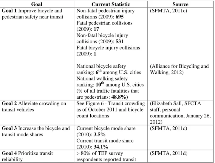
Table 3 – Citywide statistics related to bicycle-transit integration goals
Goal Current Statistic Source
Goal 1 Improve bicycle and
pedestrian safety near transit
Non-fatal pedestrian injury collisions (2009): 695
Fatal pedestrian collisions (2009): 17
Non-fatal bicycle injury collisions (2009): 531
Fatal bicycle injury collisions (2009): 1
National bicycle safety
ranking: 6thamong U.S. cities National walking safety
ranking: 10thamong U.S. cities (% of all traffic fatalities that are pedestrians: 48.8%)
(SFMTA, 2011c)
(Alliance for Bicycling and Walking, 2012)
Goal 2 Alleviate crowding on
transit vehicles
See Figure 6 - Transit crowding as of October 2011 and bicycle count locations
(Elizabeth Sall, SFCTA staff, personal
communication, January 26, 2012)
Goal 3 Increase the bicycle and
transit mode shares
Current bicycle mode share (2010): 3.5%
Current transit mode share (2010): 34.1%
(SFMTA, 2011c)
Goal 4 Prioritize transit
reliability
> 80% of TEP survey respondents reported transit
reliability as important for SFMTA to improve (greater than any other area such as peak service or travel time)
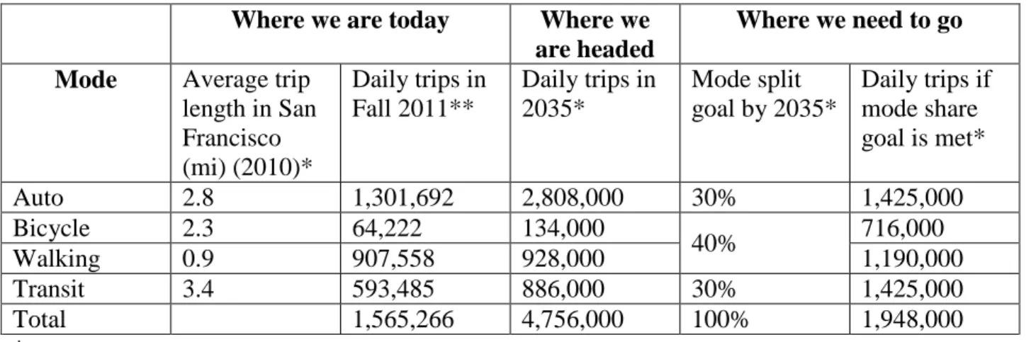
Table 4 shows data from the SFMTA’s Climate Action Strategy and the SFCTA travel demand modeling team that provides insight into the future of San Francisco’s transportation system and the need for bicycle-transit considerations now. These data suggest first that average trip lengths in San Francisco are similar across modes, highlighting the potential for mode substitution for many trips. The data also demonstrate that a status-quo policy will leave the city far short of its 2035 mode share goals – actions must be taken now to encourage more bicycling and transit use in the future.
Table 4 - Trips by mode, 2011 and 2035
Where we are today Where we
are headed
Where we need to go
Mode Average trip
length in San Francisco (mi) (2010)*
Daily trips in Fall 2011**
Daily trips in 2035*
Mode split goal by 2035*
Daily trips if mode share goal is met*
Auto 2.8 1,301,692 2,808,000 30% 1,425,000
Bicycle 2.3 64,222 134,000
40% 716,000
Walking 0.9 907,558 928,000 1,190,000
Transit 3.4 593,485 886,000 30% 1,425,000
Total 1,565,266 4,756,000 100% 1,948,000
* (SFMTA, 2011)
17
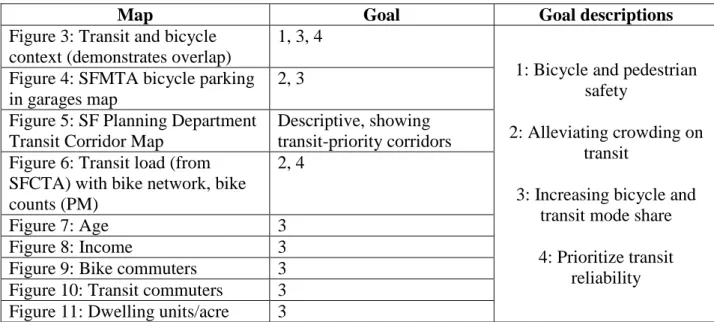
2.3.2Maps
Maps are used to describe the bicycle and transit context in San Francisco. These maps specify factors that are relevant for bicycle-transit integration. Each of the factors is tied with one or more of the project goals (see Vision, Goals & Objectives). This linking of current conditions with desired futures (goals) facilitates the choice of focus corridors that offer the greatest potential for project success.
The table below lists the nine mapsincluded in the next few pages. This linkage between the mapped factors and study goals is displayed in Table 5. The third column is simply a reference for the reader. The maps were created using data from the SFMTA, SFCTA and the American Community Survey 2006-2010 five-year estimates.
Table 5 – Map catalog
Map Goal Goal descriptions
Figure 3: Transit and bicycle context (demonstrates overlap)
1, 3, 4
1: Bicycle and pedestrian safety
2: Alleviating crowding on transit
3: Increasing bicycle and transit mode share
4: Prioritize transit reliability Figure 4: SFMTA bicycle parking
in garages map
2, 3
Figure 5: SF Planning Department Transit Corridor Map
Descriptive, showing transit-priority corridors Figure 6: Transit load (from
SFCTA) with bike network, bike counts (PM)
2, 4
Figure 7: Age 3
Figure 8: Income 3
Figure 9: Bike commuters 3 Figure 10: Transit commuters 3 Figure 11: Dwelling units/acre 3
2.3.3Map summary
This catalog of maps offers a broad description of the San Francisco population and the bicycling and transit conditions citywide. Several points are highlighted in the mapping exercise that lead to the designation of three corridors for special bicycle-transit integration consideration:
Polk/Van Ness; Mission/Market and Mission/Valencia; and along the N-Judah light rail line.
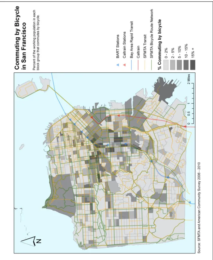
There is a high density of transit and bicycling commuters along the Mission Street corridor, the Panhandle and Golden Gate Park areas, and in Hayes Valley as demonstrated in Figure 9 and Figure 10.
Neighborhoods with the densest concentration of people aged 24-44 and households earning at least $75,000 annually include the Mission/Castro area, the Panhandle, SOMA, and along the Van Ness corridor (Figure 7 and Figure 8). These are areas with a population likely to ride a bicycle, based on results from a 2011 SFMTA bicycle survey.
The densest areas of the city, also a factor in bicycle and transit use, are north of Market Street and east of Van Ness Avenue (Figure 11).
Lastly, some of the highest bicycle count locations are in close proximity to the most crowded Muni lines (Figure 6).
19 Figure 3 - Bicycle and transit networks, bicycle parking, and bicycle counts
Figure 4 - SFMTA Bicycle parking and network map
SFMTA bicycle parking in garages map (SFMTA, 2012)
21 Figure 5 - SF Planning Transit Corridors map
23 Figure 7 - Age distribution in San Francisco
25 Figure 9 - Bicycle commuting in San Francisco
27 Figure 11 - Residential density in San Francisco
3.
Polk Street
The citywide SFMTA bicycle-integration project will focus on several corridors in San
Francisco; the remainder of this report focuses on just one of those. Given the existing citywide conditions discussed above, the focus was on Polk Street – a complement to Van Ness Avenue in the transit and bicycle networks. The Polk Street corridor presents several opportunities as well as challenges for bicycle-transit integration. A BRT line is currently being planned for Van Ness Avenue as mentioned above. Polk Street, running parallel one block east of Van Ness, is part of both the bicycle and transit networks. While the focus was on Polk Street, Van Ness Avenue was also considered where appropriate due to its proximity, regional importance, and planned transit changes. Figure 12 demonstrates Polk Street’s importance in the bicycle network.
Following the map, the existing conditions of several important street, network, and built environment characteristics are reported for Polk Street. Bicycle counts, upcoming bicycle projects, transit network characteristics, 19-Polk frequency, boardings and alightings, 19-Polk bus stop characteristics, vehicular volume, intersection control, driveways, way finding signage, bicycle network characteristics, automobile parking, topography, street classification, geometric design, historic 5-year collisions, signal timing, zoning, way-finding signage, pedestrian volume, BSP street classification, and bicycle parking all were recorded in detail. A table with detailed descriptions of each of these parameters is in Appendix E – Detailed Existing Conditions.
Figure 14 - Northern Polk Street driveways (image credit: Terra Curtis)
Figure 13 - Northern Polk Street Segment
3.1
Northern Polk Street: Beach Street to Filbert Street
The northern section of Polk Street is primarily residential; however the BSP classifies the area as mixed. The two northernmost blocks are considered Park Edge; the next two blocks are Residential Throughway, and the remaining three blocks are considered Commercial Throughway.
31 Figure 15 - School-time pedestrian traffic,
Polk at Bay Street (image credit: Terra Curtis)
north- and southbound stops at the intersections of Polk and North Point, Polk and Francisco, and Polk and Lombard.
Vehicle volume is also low here; however, the latest measures are from 1995. These figures indicated that southbound traffic is slightly higher than northbound traffic (as measured at Chestnut Street). This information, though, is likely unreliable due to the length of time that has passed since it was collected. Anecdotally, traffic volume is much lighter in the northern segment than elsewhere.
In a separate project, pedestrian volumes had been modeled for all intersections citywide. As one might expect, estimated annual pedestrian volumes are lowest in this section of Polk Street as well. If ranked in order by estimated annual pedestrian volume, all eight of the intersections in this area of the corridor are in the bottom ten. Figure 14shows the relatively low pedestrian volume, which anecdotally appears to be highest around school access times. Figure 15 was taken as children were leaving the Galileo Academy at Polk and Francisco.
Due to the low vehicle activity, most intersections here are stop-controlled. Only two of seven intersections are signalized – Polk at North Point and Polk at Bay Street. These two signal heads also include pedestrian countdown signals. At North Point, pedestrians crossing Polk on the south side of the intersection get a slightly longer walk phase than those crossing the north side due to an eastbound protected left-turn phase.
Most of Polk Street has a width of 44’-9” – enough in this section to include parallel parking on both sides, two travel lanes, and a 5’ bicycle lane in the southbound (uphill) direction. Given this width and its residential character, the BSP
recommends considering corner curb extensions and marked crosswalks.
Figure 16 - Northern Polk Collisions
This portion of Polk Street is steep; five of seven blocks have at least a five percent grade; three have greater than 10 percent. Bicycle lanes are provided on these blocks in the uphill direction; a continuous lane runs along the west side of the street along these seven blocks and east-side lanes begin at the two southernmost blocks of this segment. Two bicycle way finding signs were seen in this segment (signs marking bicycle routes 4 and 25 are located at Polk and Francisco).
Using the Statewide Integrated Traffic Records System (SWITRS), one can collect historical collision data. Information was pulled on historic bicycle-pedestrian, bicycle-transit, bicycle-automobile, pedestrian-automobile, and transit-pedestrian collisions for the 2006-2010 five year time period. This low-volume section of Polk Street saw only seven
collisions in this five-year time period, and each of them involved an
33 Figure 17 - Central Polk Street Segment
3.2
Central Polk Street: Filbert Street to Golden Gate Avenue
The central segment of Polk Street encompasses 20 blocks, much larger than the residential section to the north. The land use is primarily commercial,
especially along the ground floor. Not surprisingly, the BSP
classifies this segment as Commercial Throughway. Special consideration is needed here for high levels of pedestrian activity, transit function, and loading zones for local
businesses. Also due to this land use, there are very few driveways (about 1.5 per block); only three blocks have more than three driveways. Still, curb space is in demand – because of its
commercial nature, there is a high need for delivery access here. This may explain the use of sharrows rather than bicycle lanes in over half of the blocks in this section. Figure 18 shows
sharrows on Polk at California and a delivery truck parked in the distance.
In contrast to the northern
section, central Polk Street experiences a lot of activity. Of the 23 intersections in this section, seven have estimated annual pedestrian volumes of over 10 million people; the average is about 8.3 million. To put that figure into perspective: the northern section expects less than a tenth that volume annually.
Figure 18 - Sharrows along Central Polk (image credit: Terra Curtis)
to the northern section of Polk; 336 cyclists were counted in September 2011 – triple that of the northern intersection where counts were conducted.
Vehicular traffic is relatively light here as well, but higher than in the northern section. In March 2009, average daily traffic at Broadway was 4,680 vehicles in the southbound direction and 5,351 in the northbound direction.
35 Figure 21 - Bicycle lane and parking lane
overlap, Polk between Ellis and O'Farrell (image credit: Terra Curtis)
peak periods. This pattern suggests that passengers are using the 19-Polk to access downtown primarily, and most of the northbound passengers are using the 19-Polk to access the commercial zone.
The curb-to-curb width through this section also is 44’-9” with two travel lanes, one in each direction. On the northern-most block (between Filbert and Union), there are 5’ bicycle lanes on either side of the street. However, moving southward, though this 44’-9” width is maintained, sharrows are employed rather than bicycle lanes. At Geary, Polk widens slightly to 48’-9” and a 13’ shared bicycle lane/parking lane is used on both sides of the corridor through to Turk Street. At Turk, the last intersection of this segment, the 48’-9” width includes 2-5’ bicycle lanes; on the west side of the street, this lane abuts an 8’ parking lane; on the west side the 5’ lane runs
curbside. Figure 21 shows how overlapping the bicycle and parking lane induces a bicyclist to ride closer to the lane of traffic.
Bicycle way finding signs are located at Pacific and Post Streets in the northbound direction.
This central segment of Polk has metered parallel parking along its length with 7’-8’ parking lanes; there is one block (between Turk and Golden Gate Avenue) with metered parallel parking on the west side only. The east side of the street is bordered by the Phillip Burton Federal Building, and no on-street parking is allowed along its façade. On-sidewalk bollards guard the sidewalk and building from the street right-of-way.
Figure 22 - Central Polk Collisions The topography along this
commercial segment is amenable to biking. Slopes never rise above 10 percent. The crest of the hill over which Polk runs is in this segment as well, between Jackson and Sutter Streets.
As one might expect, there have been more bicycle, pedestrian, and transit-related crashes in this higher-volume segment of Polk Street (collisions have been aggregated by intersection in Figure 22 because of the scale of this map). Between 2006 and 2010, a total of 90 bicycle-pedestrian, bicycle-transit, transit-pedestrian, bicycle, or auto-pedestrian crashes occurred here. Transit vehicles were involved in five of these 90 – however only one of these involved a regular Muni vehicle. The other four collisions involved a private transit vehicle.
Almost all other collisions in this segment involved an automobile (with either a pedestrian or
bicyclist). The one that did not was a pedestrian-bicyclist collision at Geary and Polk. The bicyclist was traveling south along Polk and the
Figure 23 - Southern Polk Street Segment
3.3
Southern Polk Street:
Golden Gate Avenue to
Market Street
The southern segment of Polk Street is diverse from a land use point of view. The street name itself transitions temporarily from “Polk Street” to “Dr. Carlton B. Goodlett Place” as it runs through Civic Center in front of City Hall; much of this segment of the street contains public buildings. The BSP classifies this segment as mixed. Between Golden Gate and McAllister and between Grove and Market, Polk Street is considered Downtown Commercial; between McAllister and Grove, there is a special overlay called Ceremonial/Civic, which highlights the area’s public and governmental character.
The block between McAllister and Grove Streets, where City Hall is located, has an extremely different character from all other blocks – one side of the street is public open space, so the sense of enclosure found along the rest of the corridor is
39 Figure 24 - The constrained Polk Street right-of-way opens up here, looking south to Dr. Carlton B. Goodlett Place (image credit: Terra Curtis)
Figure 25 - Existing southbound bicycle lane on southern Polk Street (image credit: Terra Curtis)
January 2007; 14,396 southbound vehicles were counted at Polk and Hayes – the highest count of any on record for Polk Street.
The 19-Polk does not run along this southern segment (southbound 19-Polk exits Polk at Eddy; northbound service rejoins Polk Street at Geary), but the 21-Hayes runs south on Polk for the last two blocks between Grove and Market Street. There is one 21-Hayes stop on Grove at Polk with no bus shelter; in both the AM and PM peak periods, alightings far outweigh boardings here, though neither measure is very high. On average, automatic passenger count data from 2006-2007 revealed two boardings and 14 alightings in the
AM peak, with one boarding and 11 alightings in the PM. There are no transit stops on Polk in this southern segment.
In addition to the land use changes in this section, the right-of-way design also exhibits a deviation from the rest of Polk Street. Here, the 5’ bicycle lane continues southbound, however there are no northbound bicycle facilities (note: south of Grove is one-way southbound). There is a prominent continental crosswalk installed in the mid-block of Goodlett Place that leads to City Hall. The 48’-9” right-of-way between Golden Gate and McAllister widens to 71’ as Goodlett
Place passes in front of City Hall. This wide block includes two-11’ southbound vehicle lanes, a 9’ curbside parallel parking lane, and a 5’ bicycle lane between the two. The northbound side includes one travel lane and a lane of angled parking. The 5’ bicycle lane is maintained (though it shrinks to 4’ in one half-block section) through the 2-block one-way segment. The two southbound travel lanes are continued. The total width in the one-way segment returns to 48’-9”.
A contra-flow bicycle lane is expected to be implemented in fiscal year 2013/2014 on Polk Street between Market and Grove (Figure 25), extending the bicycle lanes through to McAllister Street (adding northbound bicycle facilities) and connecting with the existing bicycle lane that starts at McAllister heading northward.
Figure 26 - Southern Polk Collisions the eastern edge and a drop-off zone
on the western edge. In front of City Hall, there are a few parallel spaces on the western side of the street and angled parking on the eastern edge. South of City Hall, between Grove and Hayes there is additional
parallel parking, and the terminating block between Hayes and Market includes parallel parking along the west side of the street. On-street bicycle parking is less plentiful in this section, but generally racks are provided near intersections. There are 10 racks in all.
The topography in the southern segment is very amenable to bicycling. There are no grades greater than five percent and the slope is slightly southward – in the direction of the one-way travel.
This four-block segment saw 12 collisions in the 2006-2010 time period (see Figure 26). These collisions were mixed between bicycle-auto, pedestrian-auto, pedestrian-bicycle, transit-bicycle, and transit-pedestrian. Again, the most represented crash type involved an auto. The other
41
3.4
Summary of Existing Conditions
3.4.1General
Repaving scheduled in 2013
19-Polk buses all equipped with two front-loading bicycle racks
3.4.2Bicycle network
Polk Street is the main north-south route in this neighborhood
More bicycle lanes are provided in the southbound direction; northbound there are more sharrows or lack of markings altogether
Bicycle lanes are provided on uphill segments
The bicycle lanes are intermittent with sharrows mostly between
Many bicycle lanes lack right-side edge lines, sharing space with parked cars
There is an upcoming project to implement contra-flow bicycle lanes between Market and Grove Streets and extend a bicycle lane from Grove to McAllister
3.4.3Bicycle volumes
Moderate bicycle volumes as compared with citywide bicycle counts
Higher bicycle volumes as you go south along Polk Street
Unrealized potential as a major north-south connection for bicyclists
3.4.4Bicycle parking
On-street parking provided in central and southern segments
Garage parking available nearby (see Figure 4)
3.4.5Automobile parking
Three city-owned off-street parking garages near Polk Street (most spaces available in Southern Segment of Polk Street)
o Polk Bush Garage at 1399 Bush @ Polk (129 spaces) o Civic Center Garage at 355 McAllister @ Polk (843 spaces)
o Performing Arts Garage at 360 Grove Street (3 blocks west) (618 spaces)
417 metered parking spaces along Polk Street
o 70 percent are general metered parking, 15 percent are for commercial loading, 9 percent are motorcycle-only
o Remaining spaces are split between disabled parking, short-term (up to 30 minutes), and on-street bicycle parking and seating areas
3.4.6Transit network
Polk Street runs parallel to Van Ness/Highway-101 and upcoming Van Ness BRT; it is a supportive bicycle and transit route
There are many transit stops along the corridor, some with, some without shelters. Some mid-block and corner bulb-outs are provided on west side of street.
3.4.7Transit frequency 19-Polk Schedule
o first trip 5:15am; every 15 minutes (7am - 6pm); every 20 minutes (6pm-9pm); every 30 minutes (9pm-1am); last trip 12:45am
On-time performance
o As of 2006, the following running time was observed on the 19-Polk (Andrew Lee, SFMTA staff, personal communication, February 24, 2012). Note that the SFMTA standard for on-time performance is no more than one minute early or four minutes late. Out-of-compliance figures are highlighted by a special cell border in the table.
Table 6 – 19-Polk on-time performance
Route Segment Direction Deviation from Schedule (minutes)*
AM Peak Midday PM Peak
Beach/Polk to Sacramento/Polk
Southbound
1.9 0.7 1.4
Beach/Polk to Sacramento/Polk
Northbound
3.6 2.9 3.4
Sacramento/Polk to Post/Polk
Southbound
-1.6 -1.0 -1.0
Sacramento/Polk to Post/Polk
Northbound
-2.3 -2.6 -2.3
* positive number reflects minutes behind schedule; negative number reflects minutes ahead of schedule
43
3.4.9Vehicular volume
Generally speaking, there is more southbound than northbound traffic; the only
intersection where northbound traffic is higher than southbound is at Broadway. In most other cases, southbound traffic far outweighs northbound.
Polk is not a critical vehicular connection (Van Ness/Highway-101 runs parallel one block to the west)
3.4.10Intersection control
Intersections are mostly signalized; some stop-controlled in northern residential section
3.4.11Signal timing
No green wave or special timing for transit along Polk St. (based on Staff conversations – Valencia and 11th Streets are green wave; Geary is timed for transit)
3.4.12Driveways
There are fewer driveways as you head south on the corridor into the commercial areas
There are no designated loading areas for commercial deliveries
3.4.13Collision History
Most collisions involve an auto, especially in the central segment
“Dooring” (a collision where an automobile driver or passenger opens their door in the path of a passing bicyclist) appears to be a common collision type
o Polk @ Vallejo: 6/25/2009 o Polk @ Pine: 11/7/2008 o Polk @ Jackson: 3/8/2010 o Polk @ Eddy: 10/20/2010
o Potentially Polk @ O’Farrell: 10/23/2009
Over 40% of collisions happened in “Dark – Street Light” conditions
Particularly concerning intersections for bicyclists include o Geary Street, Broadway, Ellis Street
Particularly concerning intersections for pedestrians include o Pine Street, O’Farrell Street, McAllister Street
3.4.14Geometric design
Bus bulb-outs are provided only on western side of street, only at some transit stops
Polk Street is mostly a ~45-50’ right of way with parallel parking either side; Goodlett Place opens to 71’
Sidewalks are typically 10-12’
3.4.15Zoning/Land Use
4.
Needs Assessment
Existing conditions were synthesized to identify the gaps between the status quo and those conditions under which the study’s goals would be met. In order to illustrate that link, the needs that result from the synthesis were linked to corresponding goals. The needs form the basis of recommendations presented later in this report.
The issue areas were examined on three different scales: the Polk Street corridor and neighborhoods; specific point locations; and the broader citywide context.
4.1
Corridor and neighborhood needs
The overall Polk Street corridor has several needs that, if addressed, would further the
achievement of the four main goals of bicycle-transit integration. Needs were matched to those goals that would be primarily or secondarily addressed by focusing investment in that need area (Table 7 through Table 9).
Table 7 – Corridor and neighborhood needs
Need Goals
Clearer delineation of space
Polk Street is shared among Muni buses, bicyclists, pedestrians, and automobiles. It is not a primary corridor in the automobile or transit networks; however, it is the only north-south bicycle connection in this neighborhood and will become an increasingly important support to Van Ness Avenue as a major bicycle
throughway. Pedestrian activity is also high here because of the corridor’s commercial character and proximity to transit lines. The physical layout of the street does not reflect the needs of these four user groups; the quality of the bicycle route has been compromised by the prioritization of automobile access. Transit reliability is questionable, especially in the northbound direction between Post and Sacramento Streets (ahead of schedule) and from Sacramento to Beach (behind schedule). Any
recommendations for changes to the delineation of space need to take this performance into account so as not to exacerbate an existing problem.
Goal 1: Improve pedestrian and bicyclist safety
Goal 2: Alleviate crowding on Muni
Goal 3: Increase bicycle and transit mode share
45 Additionally, Polk Street will need to support the future users of
the Van Ness BRT. As a BRT corridor, Van Ness itself will need to prioritize longer-term, secure bicycle parking to enable to bicycle as an access/egress mode. It is likely that bicycle sharing stations will eventually be used to support the BRT line as well; Polk Street’s commercial section needs to be supported by at least one bicycle sharing station as a complement to Van Ness.
Safety improvements throughout central and southern Polk
Bicycle-pedestrian and bicycle-transit collisions are concentrated in the southern half of Polk Street. Overall, collisions involving automobiles are the most common, and often a right or left
turning movement is involved. The central and southern segments see most of the corridor’s pedestrian and bicyclist activity, so collisions should be expected more frequently here. Pedestrian scale lighting may be needed; many collisions occur under conditions of darkness. Additionally, there are no protected bicycle facilities anywhere along this corridor. If increases in bicycling, walking, and transit use are to be realized (which is the goal of the SFMTA), then these patterns can only expect to continue unless preventative action is taken.
Goal 1: Improve pedestrian and bicyclist safety
Goal 3: Increase bicycle and transit mode share
Enhanced bicycle network connections
Currently, several bicycle routes intersect with Polk Street, however only a few of those routes are Class II facilities (bicycle lanes); the others are Class III routes only (usually marked by sharrows). Bicycle connections specifically between Van Ness and Polk Street should be enhanced. One important connection is along Green Street, which would connect the northern Polk residents to the northernmost BRT stop at Union Street. Other important connections in the central segment of Polk include Broadway, Sutter, and Post Streets. These connections could support the future BRT and bicycle sharing systems, and provide additional bicycle traffic to the Polk Street commercial zone. They could also help alleviate crowding on north-south transit routes serving this dense residential neighborhood by providing more visible, comfortable, and safe bicycle network connections.
Goal 1: Improve pedestrian and bicyclist safety
Goal 2: Alleviate crowding on Muni
Goal 3: Increase bicycle and transit mode share
Enhanced bicycle network along Polk Street
Bicycle facilities on Polk Street currently transition between Class II and III facilities; the quality of the route is not consistent
throughout though the road geometry is fairly uniform. In order to become a clear complement to the future Van Ness BRT corridor, serve some of the north-south demand, and enhance access to local businesses, the bicycle route along Polk Street should be enhanced. Timing of signals could be considered to aid the flow of bicycle traffic.
Goal 1: Improve pedestrian and bicyclist safety
Goal 2: Alleviate crowding on Muni
Goal 3: Increase bicycle and transit mode share
Consideration of automobile parking
San Francisco’s innovative parking pricing pilot project, SFPark,