SEEKING CLARITY IN POSTHOLES:
AN EXAMINATION OF COLES CREEK EARTHFAST ARCHITECTURE
By
Isaac M. Warshauer
Honors Thesis Curriculum in Archaeology
University of North Carolina at Chapel Hill
2015
Approved:
ABSTRACT
Isaac Warshauer: Seeking Clarity in Postholes: An Examination of Coles Creek Earthfast Architecture
(Under the Direction of Vincas P. Steponaitis)
ACKNOWLEDGMENTS
My thanks go, first and foremost, to Vin Steponaitis, who, as my advisor, patiently provided me with the guidance and left me with the independence necessary for this scholarly endeavor. I cannot help but express my gratitude to Steve Davis and Margaret Scarry for their support, not only as patient members of my thesis committee, but as faculty who have always left their doors open to my inquiries and explorations. I must also thank Rebecca Saunders and Beverly Nuschler at the Louisiana State University Museum of Natural Science for their help obtaining better images of WPA excavation maps. I owe my gratitude to Amanda Henley of UNC Libraries for her essential guidance with GIS software. My deep appreciation goes to my family and friends, especially my parents, for their continual encouragement and support,
TABLE OF CONTENTS
List of Figures ... vii
List of Tables ... xi
Introduction ... 1
Chapter I: Mounds, Structures, and the Lower Mississippi Valley ... 3
The Coles Creek Culture and Late Prehistory ... 6
Chapter II: “Moundbuilders” And Their Earthfast Structures ... 12
Mississippian Earthfast Architecture ... 14
Coles Creek Earthfast Architecture ... 21
Chapter III: Sites Studied ... 24
Baptiste Site ... 25
Gordon Site ... 27
Greenhouse Site ... 29
Nick Farm Site ... 33
St. Gabriel Site ... 34
Chapter IV: Methods ... 36
Diameter Analysis and Prezzano Spacing Analysis ... 38
Problems of Posthole Analysis ... 41
Chapter V: Results ... 44
Baptiste Site ... 47
Mound A ... 47
Mound B ... 49
Village ... 51
Gordon ... 55
Mound B Zone 1 ... 55
Mound B Zone 2 ... 61
Greenhouse ... 65
Mound A ... 65
Mound F ... 69
Mound D ... 74
Nick Farm ... 77
Mound A ... 77
Mound B Submound ... 80
St. Gabriel ... 85
Chapter VI: Discussion ... 89
Chronology ... 89
Bent-Post Structures ... 90
Rigid-Post Structures ... 97
Large-Scale Enclosures ... 97
Greenhouse Structures: Mounds A and F ... 100
General Conclusions ... 102
LIST OF FIGURES
Figure 1. "Pole Construction" as illustrated by Lewis and Kneberg. ... 16
Figure 2. "Log Construction" as drawn by Brian Sullivan. ... 16
Figure 3. Distribution of Coles Creek sites studied.. ... 25
Figure 4. Baptiste site.. ... 26
Figure 5. Gordon site. ... 28
Figure 6. Greenhouse site with WPA excavations indicated. ... 30
Figure 7. St. Gabriel site in the 1970s on the location of a planned prison facility. ... 34
Figure 8. Detail from a feature map of Mound B at the Baptiste site. ... 40
Figure 9. Profile of Mound B, Gordon site, showing slanted postholes (termed molds) with widened bases. ... 46
Figure 10. Feature 909, Mound A, Baptiste site. ... 48
Figure 11. Features under Mound B, Baptiste site.. ... 50
Figure 12. Baptiste Village. ... 52
Figure 13. Architectural Evidence from Mound B, Zone 1, Gordon site.. ... 56
Figure 14. Mound B, Zone 1, Gordon site. Adapted from Cotter (1952:Figure 53). ... 57
Figure 15. Feature 4a, Mound B, Zone 1, Gordon site.. ... 58
Figure 16. Feature 4b, Mound B, Zone 1, Gordon site. ... 60
Figure 17. Feature 5, Mound B, Zone 1, Gordon site. ... 61
Figure 18. Features found at Level 2, Mound B, Gordon site.. ... 62
Figure 20. Feature 7, Mound B, Zone 2, Gordon site ... 63
Figure 21. Feature 8, Mound B, Zone 2, Gordon site. ... 64
Figure 22. Greenhouse Mound A, Building Level 6. ... 66
Figure 23. Greenhouse Mound A, features just under Building Level 7. ... 68
Figure 24. Greenhouse Mound F, Building Level 1. ... 68
Figure 25. Greenhouse Mound F, Building Level 1, with all sub-floor posts removed, showing discovered alignments. ... 71
Figure 26. Greenhouse Mound F. Building Level 1. This image shows paired posts and an S-shaped alignment in red. Alignments from Figure 25, extended with additional posts, are colored in blue. ... 71
Figure 27. Greenhouse Mound F, Building Level 1. Alignments and possible paired posts resulting from Prezzano analysis are colored red.. ... 72
Figure 28. Greenhouse Mound F, Building Level 3. ... 73
Figure 29. Features under Greenhouse Mound D. ... 75
Figure 30. Feature 274, Mound A, Nick Farm site. ... 78
Figure 31. Posts (in red) with diameters greater than six inches extend into the eastern wall of Feature 274 from the extraneous wall. ... 79
Figure 32. Structures under Mound B, Nick Farm site. ... 80
Figure 33. Feature 10, under Mound B, Nick Farm site. ... 81
Figure 34. Feature 105, under Mound B, Nick Farm site. ... 83
Figure 35. Feature 168, under Mound B, Nick Farm site. ... 84
Figure 36. Feature 3 under the mound at St. Gabriel site. ... 86
Figure 37. Outward-leaning postmold from house 65 at the Hixon site, Tennessee. ... 87
Figure 38. Features found at Level 1, Mound A, Medora site. ... 93
Figure 40. Watercolor by John White depicting an enclosure of posts in coastal North Carolina in the 16th century. ... 98
LIST OF TABLES
INTRODUCTION
The activity of setting posts was ubiquitous in the prehistoric Lower Mississippi Valley. Wooden posts formed the structures of many buildings, including domestic dwellings and public structures, and carried religious importance themselves. Timothy R. Pauketat and Susan M. Alt, in asserting the agency evident behind postmolds, the archaeological impression of posts, stated that postmolds represent “embodiments of labor, sociality, and identity” (2005:218). But obtaining this information from a soil stain requires being able to understand the subtleties of the work of post-setting, in addition to having a detailed archaeological information about the posts. Although this resolution may be present in the archaeology of Cahokia and its hinterland, the focus of Pauketat’s and Alt’s work, it is not yet evident for architecture of the Coles Creek period in the Lower Mississippi Valley.
This study attempts to augment the record of the Coles Creek postmold and its constant partner, the posthole, by gathering information about these archaeological features and the structures they formed from maps of excavations of Coles Creek sites. This information was found by parsing through published site reports and articles, examining maps, and applying image analysis and geographic information systems (GIS) tools to the excavation maps and figures that featured structural evidence. With data obtained from this investigation, this study attempts continue the work of Cherie A. Schwab (1998) in moving beyond large-scale
landmark work on Plaquemine architecture—and beginning to examine what these features meant to their creators and how they reflected the society of those ancient American Indians.
This study focuses on architecture found at Coles Creek sites in the Mississippi Valley from about Vicksburg in the north to the vicinity of Baton Rouge, examining evidence at the sites of Baptiste (16Av25), Gordon (22Je501), Greenhouse (16Av2), Nick Farm (16Av22), and St. Gabriel (16Iv128). It omits, notably, one site with particularly strong evidence for Coles Creek Architecture, the Morgan site (Fuller and Fuller 1987), which, because of its location in coastal Louisiana, as well as its anomalous and opaque posthole arrangements, possessed unique problems that limited comparability and warranted a thorough examination on its own.
As evidence of Coles Creek architecture is found primarily at mound sites, this study begins with an examination of the prehistory of the Lower Mississippi Valley—Chapter I—with a focus on mound construction and associated earthfast structures, or structures supported by posts set in the ground, before providing a survey of current knowledge about the Coles Creek culture and late prehistory. Chapter II is an overview of the major debate about earthfast
architecture in the better-studied Mississippi period, the distinction between rigid-post and bent-post dwellings, and an examination of current scholarship on Coles Creek earthfast architecture. Chapter III describes the sites included in this study and summarizes archaeological
CHAPTER I
MOUNDS, STRUCTURES,
AND THE LOWER MISSISSIPPI VALLEY
The Lower Mississippi Valley has been described as “the cradle of cultural development in eastern North America south of the Arctic” (Brain 1971:2). When it comes to the construction of earthen mounds, the region may certainly claim that title. Mound construction began in the Lower Mississippi Valley in the Middle Archaic period before 3000 BC. Excavations in Louisiana have revealed Archaic mound sites of a variety of sizes, from single-mound sites to sites such as Watson Brake, with eleven mounds. These mounds took a variety of forms, ranging from conical to dome-shaped—as at Watson Brake (Saunders 2010:68-69).
The abandonment of the Poverty Point site around 1300 B.C. (Gibson 2006:315) accompanied a large transition in the lifeways of the Lower Mississippi Valley, long-distance trade decreased, but new technology, in the form of pottery, made its first extensive appearance (Hays and Weinstein 2010:98, 104). This transition marked the movement from the Archaic to the Woodland period. The Early Woodland period in the Lower Mississippi Valley, called the Tchula period, has been subdivided between the Tchefuncte and Lake Cormorant cultures (Kidder 2002:69). Subsistence was still attained exclusively by hunting and gathering, but settlements were almost all small and nearly sedentary, oriented near slow-moving bodies of water (Hays and Weinstein 2010:104-105; Kidder 2002:70-71). Shell middens are evidence of extensive exploitation of riverine and coastal resources (Hays and Weinstein 2010:105). Mound sites were rare in this period; most were constructed as communal places of interment for flexed and bundle burials, but a few Lake Cormorant mounds were pyramidal with platforms (Hays and Weinstein 2010:107). Postholes found at Tchefuncte settlements may indicate earthfast
structures. At the site of Little Oak Island in Louisiana, postholes seemed to indicate a shed-like structure (Hays and Weinstein 2010:105). At the mound site of Lafayette, an arc of postholes underneath the mound was compared to circular posthole arrangements under Adena mounds in Kentucky (Ford and Quimby 1945:21).
truncated, creating a possible platform. Mounds could also be enclosed or connected with embankments of earth (Hays and Weinstein 2010:75). The Marksville culture is considered part of the Hopewell Interaction Sphere, an area of cultural exchange across the Eastern Woodlands. Traits related to this cultural interaction are evident in the mortuary mounds, which included log-covered burials resembling those of the Illinois Hopewell (Kidder 2002:76, 79; Walker 1975:19-24). Trade with other Hopewellian cultures is evident until AD 300 (Brain 1971:62).
The Coles Creek Culture and Late Prehistory
Between AD 700 and 800, with changes in pottery and mound construction, the Coles Creek culture emerged from the Baytown and Troyville across the Lower Mississippi Valley (Kidder 2002:75-76). Well-made pottery, which emphasized incised or stamped decoration near the rim and was tempered with fired clay, defines the Coles Creek, and arrowheads predominate the lithic assemblage (Roe and Schilling 2010:167-168). Distinctive ceremonial centers also developed, which included platform mounds arranged around a plaza (Brain 1971:69).
People of the Coles Creek culture continued use of domesticated seed crops, but mostly exploited rich wild resources of the local environment (Roe and Schilling 2010:169). It was formerly thought that the Coles Creek people conducted maize agriculture, as the culture’s permanent settlements around mound centers were reminiscent of the later Mississippian culture (Brain 1971). More recent investigations have shown that this was not the case; maize began to be farmed only at the end of the Coles Creek (Fritz 1998:34-36). Bioarchaeological and
zooarchaeological information suggests that the bow and arrow may have increased the quantity of meat in the Coles Creek diet, and suggests that starchy foods, whether small quantities of maize or native starchy crops, increased in the Late Coles Creek (Listi 2008).
the site (1983:333-334). The increased presence of mound-top structures, although perhaps not universal, has been taken as an important characteristic of the Coles Creek culture. These structures, however, have been variously interpreted as elite residences, charnel houses, and council houses (Roe and Schilling 2010:163-164).
Kidder suggests that the structures on mounds, because they were often placed over burials and other mortuary features underlying the mound, were likely occupied by high-ranking people seeking to legitimize their status by connecting themselves with ancestors (Kidder
2002:87). Examinations of faunal remains indicate that some mammals, such as deer, were consumed in greater quantity on top of mounds; this may be an indication of the higher status of those eating on mounds (Roe and Schilling 2010:166), but it may also simply indicate that special forms of food consumption occurred on mound summits.
The Coles Creek plaza is usually clean of human artifacts, but it can be delineated by a midden around the periphery, between surrounding mounds, as at Greenhouse (Roe and Schilling 2010:161). Over the course of the Coles Creek period, access to the plazas generally became more restricted as more and larger mounds were constructed on the periphery. In addition, settlements became more closely associated with mound centers (Roe and Schilling 2010:162). There is some evidence that feasting occurred at mound sites, but artifact assemblages indicate that largely similar types of activities were conducted at mound sites and non-mound villages. It remains somewhat unclear how the mound-plaza complexes functioned. One theory is that the mound sites supported small, high-status residential populations and functioned as ceremonial centers for surrounding settlements (Roe and Schilling 2010:162-163).
often placed in mounds but generally lacked any grave goods. Some archaeologists have identified central bodies in mass burials, as at Lake George and Mount Nebo (Kidder 2002:86), as the remains of important individuals, and others have argued that there is a social distinction between mound burials and others, but no interpretation is conclusive (Roe and Schilling 2010:165-166). Kassabaum (2011), examining the mortuary record at Lake George, Mount Nebo, and Greenhouse sites, found that Coles Creek burial methods differed according to the age, rather than the status, of an individual. She noted, however, that the mortuary record might mask status differences, as the mortuary record is an indirect and inconsistent marker of social hierarchy (2011:222).
Taking the archaeological record into consideration, scholars have attempted to
understand the social organization of those within the Coles Creek culture. Using evidence from the mortuary record, the chronology of mound construction at Coles Creek sites, general
examples, demonstrating that the public architecture of the Coles Creek culture, like that of other cultures attested in the archaeological record in Mesoamerica, South America, Polynesia, and the Middle East, indicated an emerging hierarchy (Wells 1998).
Recent literature seems to contradict this conclusion. Schilling found that, in a study of coastal Louisiana settlement patterns, Coles Creek sites seemed to indicate a more egalitarian “tribal” social organization, without real settlement hierarchy, as made evident in the Mississippi Period (Schilling 2002). Evidence from the Natchez Bluffs mound site of Feltus provides
evidence of communal ritual activity that consisted of post-setting, feasting in large groups, human interment, and mound-building (Kassabaum 2014). Based on this evidence, Megan Kassabaum suggests that Coles Creek mound sites, rather than emphasizing existing social hierarchies, built on a history of communal activity. She argues that mounds did not serve as the site of exclusive ritual and elite residence, as they did in the later Mississippi period (Kassabaum 2014:348-350).
By about AD 1200, the Coles Creek culture had permeated the entire southern portion of the Lower Mississippi Valley (Brain 1971: 70), but, to the north, Mississippian societies began to coalesce across the Southeast. These peoples shared a number of cultural traits, including
intensive maize agriculture, shell tempered pottery, and artifacts decorated with elaborate mythological motifs. Mississippian society was highly hierarchical, with strongly differentiated status exhibited in the placement of burials and associated grave goods (Brain 1971:71-72, 74, 78).
the formation of alliances and violence between the two groups (Brain 1971:76; Roe and Schilling 2010:160). In this period, these political interactions, along with trade connections, may have influenced the adoption of maize agriculture by the Coles Creek, which led to the transition into what is now called the Plaquemine culture (Fritz 1998:35-36).
The exact nature of the Plaquemine culture is somewhat debated. Brain wrote that the Plaquemine was a hybrid of Coles Creek and Mississippian cultural traits, intertwined by the fully agricultural descendants of Coles Creek people. Brain cites evidence that mound sites never became fully residential and that pottery still resembled that of the Coles Creek (1971:76-77). This is supported by evidence from the Lake George site that indicates a low level of site occupation, even during an unprecedented amount of mound construction (Williams and Brain 1983:338-339). The mounds themselves exhibited features that related to larger Mississippian patterns. Williams and Brain note that, as at Mississippian sites outside of the Lower
CHAPTER II
“MOUNDBUILDERS” AND THEIR EARTHFAST STRUCTURES
The moundbuilding cultures of North American prehistory have long been of interest to scholars, as their earthen constructions are some of the most obvious indications of the ancient past of human habitation in North America. Famously, Thomas Jefferson investigated a mortuary mound with bundle burials near his home at Monticello prior to 1781(Jefferson 1853:104-106).
The question of the nature of the ancient moundbuilders had a prominent place in the research of early North American archaeologists. For nearly a century, scholars debated whether American Indians had created the mounds found in Eastern North America. Ephraim Squier and Edwin Davis wrote the first publication of the Smithsonian Institution, Ancient Monuments of the Mississippi Valley, which claimed that the builders of the region’s mounds must have been
related to those who constructed monumental buildings in Mexico and Peru (Squier and Davis 1847:301). After the 1894 publication of a Report on Mound Explorations of the Bureau of Ethnology by Cyrus Thomas, American Indians were firmly established as the moundbuilders
mid-twentieth century and has only been overturned by recent archaeobotanical evidence (Fritz 1998; Ward 1998). Such evidence demonstrates clearly that the Coles Creek people, for one,
constructed mounds in the absence of an agricultural society as mentioned in the previous section.
Given what is now understood about the length of time over which mounds were
constructed, by both agricultural and hunter-gatherer societies, archaeologists have taken a more detailed approach to the study of mound sites in order to understand the diversity of motives the “moundbuilder” Americans had over the course of millennia. These more sophisticated
approaches to the investigation of mound sites were jumpstarted during the Great Depression, with the large-scale excavations of New Deal agencies, notably the Works Progress
Administration. With unprecedented resources at their disposal, archaeologists investigated sizeable areas of many mound sites, including a majority of those examined in this study: Baptiste site, Greenhouse site, and Nick Farm site. Dealing with hundreds of laborers with little or no archaeological training, New Deal archaeologists, out of necessity, developed more
systematic means of excavation with standardized paper forms (Means 2013:10). This systematic approach to archaeology meant that some features, which had been poorly documented
previously, such as postholes, were documented on a large scale. With these discoveries, archaeologists began to devote greater energy to studying the more ephemeral structures represented by postholes and, occasionally charred remains.
not include much consideration of earthfast architecture, other than a general consideration of building shape. George I. Quimby identified square and circular structures at the Plaquemine site of Medora as temples, and postulated that they had been constructed with wattle and daub, but otherwise deflected attention to artifacts (Quimby 1951). Efforts that did devote significant energy towards earthfast architecture in the Southeast dealt with the Mississippi period, as evidence was most abundant from that time. This focus on the Mississippi period has continued to the present day, building on early work from the Great Depression era. For this reason, in order to provide an overview of the study of prehistoric earthfast architecture, I will first focus on the interpretation of Mississippian structures before considering how that has carried over into the study of the earthfast architecture of the Late Woodland period, including that of the Coles Creek culture.
Mississippian Earthfast Architecture
Thomas M. N. Lewis and Madeline D. Kneberg undertook a notable analysis of
Mississippian structures with information compiled from WPA digs in the Chickamauga Basin in Tennessee (Lewis and Kneberg 1995). These authors studied post diameter and spacing, the presence or absence of wall trenches, structure size, and interior features “such as seats, platforms, benches, cache pits, and partitions,” in order to determine structure, form, and use (Lewis and Kneberg 1995:55).
(1995:55, 67). The former, called “pole construction,” was interpreted as having “unified wall and roof construction.” Termed “bent-post construction” in this study, this meant that long, flexible poles were placed in the wall trenches and bent over to form the roof, likely resulting in a dome-like shape (Figure 1). Lewis and Kneberg noted wedges within trenches that could have resisted the outward forces generated by the bent poles. They also cited examples of postmolds that were clearly bent inward within the wall trench. At the Hixon site, the charred poles were up to 25 feet long and were interwoven, clear evidence that these posts were bent over to form the roof (Lewis and Kneberg 1995: 56-60). The latter type of construction, termed “log
construction” (“rigid-post construction” will be used elsewhere here) was interpreted as having rigid walls with roof beams attached above (Figure 2). Charred evidence suggested that wattle and daub was placed between wall posts. Many of the dwellings of log construction were built in shallow pits. Lewis and Kneberg noted that the pole buildings were common in earlier
stratigraphic levels than the log buildings, suggesting temporal changes in construction methods within the Mississippi period (1995:67-68).
Figure 1. "Pole Construction" as illustrated by Lewis and Kneberg (1995: Figure 4.2).
Figure 2. "Log Construction" as drawn by Brian Sullivan (Lewis and Kneberg 1995: Figure 4.9).
the structure and determined that, because there were no eaves to protect the daub from the rain, that the building needed to be thatched from the ground up (Sullivan 2007:123-130).
Over the next few decades, many archaeologists departed from the interpretations of Lewis, Kneberg, Nash, and Lidberg, arguing that even structures with small, closely-spaced postholes featured a separate roof structure. James A Price, after work at the Turner and Snodgrass sites in Missouri, interpreted buildings that met Lewis and Kneberg’s criteria for “pole” buildings as buildings with separate roof structures (Lacquement 2004:47-49). Mark A. McConaughy argued in a 1985 paper that most of the burned Mississippian dwellings that had been uncovered in Illinois should be interpreted as having rigid-post construction. Charred evidence of straight poles, the presence of large postholes in corners, the presence of large support posts and ridge poles (that would have supported the roofs of these structures at their apex), as well as poles that had collapsed in a radial fashion—interpreted as roof beams, indicated that structures with posts as small as 8 cm were built in this manner (McConaughy 2007:104-107, 112-113).
and permanent roof supports can be present in bent-pole structures, as well as rigid-post structures. As additional evidence, Reed pointed out that the majority of identified wood in structures was hardwood, which performs well in bent poles (Reed 2007:22-37).
In 1981, Dennis B. Blanton and Thomas H. Gresham continued the experimental
approach at the Etowah site in Georgia, recreating the plan of a small-post, wall trench structure found at the site (Blanton and Gresham 2007). Using Lewis and Kneberg’s analysis as a guide, the authors proceeded, with the help of volunteers, to create a dome-shaped structure, with interwoven bent posts set wall trenches with open corners (Blanton and Gresham 2007:37-40). This structure demonstrated that open corners were advantageous for bent-post construction, but, as with the reconstruction by Nash and Lidberg, the bent structure allowed daub on walls to deteriorate rapidly (Blanton and Gresham 2007:42. 44-46).
McConaughy, in publishing his 1985 study, returned to the subject and recognized that some of the structures he interpreted as rigid-post should instead be viewed as bent-post. However, he argues that many of his criteria remain valid; he finds it likely that bent-post and rigid-post constructions were likely built contemporaneously and featured similar floorplans (McConaughy 2007:13-16).
Lacquement, in a 2004 Master’s thesis, argued for the validity of Lewis and Kneberg’s interpretations. He built a bent-post structure with interwoven poles, following the suggestions of Lewis and Kneberg. Lacquement didn’t include daub at all, limiting the structure’s covering to thatch (2004:100-101). After five months, he burned the structure, noting that the thatch
noted the importance of horizontal supports on the bent poles in maintaining a sound structure (2004:108). Lacquement also included a survey of the structures uncovered at Moundville, in order to determine temporal changes in earthfast structures. Using dates determined by ceramic assemblages, he determined a transition from composite structures, which had two bent sides and two rigid sides (Lacquement saw these as possibly being similar to the structures encountered by John White in coastal North Carolina), to bent-post structures with individually-set posts. He found a later transition to bent-post structures with wall trenches, followed by a move toward rigid-post structures with large, widely spaced posts (Lacquement 2004:131-145). Lacquement argues that this change in construction may have been the result of a number of possible factors: Increasing household complexity may have caused the shift, for rigid-post structures were, on average, greater in size and contained room for partitions (2004:136, 140). Cooling in the Little Ice Age may have encouraged architecture with thicker daub application (2004:137-138). Thirdly, the supply of straight saplings may have become depleted (2004:138-140).
In contrast, Laura Brennan, in a recent study (2007), deviates from what seems to be the dominant view and reinterprets the structures found at the Kincaid site as having rigid posts. She emphasizes that the pits of some Mississippian houses, as well as earth applied to the outside of walls, would reinforce narrower poles, allowing them to support a separate roof. Brennan emphasizes that few single features of a structure can rule out bent or rigid construction, although large postmolds can definitively rule out bent construction (Brennan 2007:82-83).
As shown above, studies of Mississippian earthfast construction have generally revolved around one main issue, which has not yet been completely resolved: possible changes in
structures of the Coles Creek culture, as many similarities exist between the remains of earthfast buildings of these two cultures.
However, there is much more to a structure than whether it had bent or rigid posts. Other authors have fruitfully examined other aspects of earthfast structures. David Hally, in his study of the King site, a late Mississippian Town, postulates that the sunken rigid-post structures found at the site (called “primary dwelling structures”) were likely winter dwellings for the inhabitants of northern Georgia. Lightly constructed arbors ( termed “rectangular structures”) were likely used in the warmer months (Hally 2008:50-120). Hally cites ethnohistorical accounts to
document the presence of seasonal dwellings in the region. He also includes strong evidence of partitions within the primary dwelling structures that likely divided household activities
(2008:88-92, 100-106). In what he identifies as the plaza of the King site, he found a complex of three associated structures that he identified as public buildings: a possible temple, a council house, and a pavilion for warm weather use. These were identified on the basis of interior
features, including benches in the council house, ceremonial ash deposits outside the temple, and the presence of large numbers of burials (Hally 2008:121-151).
In a massive salvage excavation in anticipation to dam construction, Richard R.
Polhemus, among others, completed excavations at the Mississippian Toqua site in Tennessee. In reporting the findings, Polhemus paid particular attention to the 133 structures uncovered,
the posthole and the postmold. His work on this subject will be included in a following section. Polhemus also examined artifact scatters within dwellings to get at information about structure use. Polhemus wrote that the early buildings, of Lewis and Kneberg’s “pole” construction type, generally had cleaner floors and no evidence of either partitions or elaborately-formed hearths. The rigid-post Dallas Phase structures featured partitions that divided living spaces around a central area containing the hearth. Polhemus noticed that debris accumulated in the peripheries of the buildings. Public buildings, according to Polhemus, resembled the domestic structures but were larger and with less food and craft debris (1987:259).
Coles Creek Earthfast Architecture
The authors mentioned previously have studied a variety of aspects of late prehistoric construction, including physical appearance (whether bent-pole or rigid-pole), temporal changes in construction methods, forms of use (e.g. community structures, dwellings, outbuildings, winter dwellings, summer dwellings), interior patterns of use, and duration of use. Few authors have investigated the same research questions with regard to the Coles Creek culture, but a few studies stand out.
John L. Cotter, in a study of the Gordon site (1952), stemming from the late Coles Creek and Early Plaquemine cultures, noted, upon comparing the architecture of his site with that of Greenhouse and Medora sites, that there seemed to be a general trend from circular to
rectangular structures, regardless of whether a wall trench were used.
Ian W. Brown (1985) studied the architecture of the Lower Mississippi Valley’s
between the two periods. Brown used a narrow range of criteria, considering only buildings shape (circular or rectangular) and the presence or absence of a wall trench to evaluate temporal patterns. Looking at a variety of sites in the region around the Natchez Bluffs, including the Greenhouse and Gordon sites (considered in this study), Brown determined that architecture transitioned from a circular wall trench form to circular structures without wall trenches in the south of the region, while also moving into rectangular shapes. To the north, in the Yazoo River Basin, rectangular structures predominated and moved toward wall trench construction. In the Plaquemine, rectangular structures with individually-set posts predominated in the south, while wall trenches remained common in the north. Brown notes the presence of circular structures without wall trenches in the early Plaquemine in the Natchez Bluffs (primarily citing evidence from Gordon).
CHAPTER III
SITES STUDIED
This study of Coles Creek earthfast architecture includes evidence from five sites from
Mississippi and Louisiana (Figure 3). Baptiste, Greenhouse, and Nick Farm sites, located in
Avoyelles Parish, Louisiana, were excavated by the Works Progress Administration between
1938 and 1940, under the direction of James A. Ford and Robert S. Neitzel. Neitzel managed the
excavations in the field (Ford 1951:12; Schwab 1998:2; Whitmer 1987:3). Gordon site, in the
Natchez Bluffs, was excavated by John L. Cotter prior to the 1950s (Cotter 1952). St. Gabriel
site near Baton Rouge was excavated by Deborah K. Woodiel in the 1970s (Woodiel 1993). As a
result, this study focuses heavily on WPA information from sites in the Marksville area, with
Figure 3. Distribution of Coles Creek sites studied. Sites studied are marked in red. Other relevant Coles Creek sites with architecture are marked with black. Basemap courtesy of National Geographic and ESRI.
Baptiste Site
Baptiste site (Figure 4), located five miles south of the Marksville site in Avoyelles
Parish, Louisiana, includes two small mounds. The site was under cultivation when excavated, so
the mounds were not well preserved (Whitmer 1987:3). Despite cultivation, a total of 22
structures were identified at Baptiste, primarily found in a large excavated area between the two
mounds (Whitmer 1987:122). All of these features were found at the bottom of the cultural
in what was called “Phase 5,” and the likely originated within or on top of a midden layer just
above the construction phase (Whitmer 1987:93). Mound B included no evidence of distinct
cultural phases (Whitmer 1987:94). Underneath Mound B, excavators found “postmolds and
pits” dug into the subsoil (Whitmer 1987:Table 14, 96). Above these postmolds was a
“brownish-black midden,” termed Zone IV, which contained burned clay and a layer of charcoal.
In between the mounds, the postholes indicated a group of circular and rectangular houses.
Figure 4. Baptiste site. Mound A is at center; Mound B is in the upper right. The area designated the "Village" is located between the two mounds. Excerpted from Whitmer (1987: Figure 25).
Ann Whitmer, in a 1987 Masters thesis, studied the WPA field documents from the
1939-1940 excavation of Baptiste to complete analysis of the site structure. Whitmer writes that the
field notes indicated postholes were difficult to spot within dark midden soils found in the
1987:117). This suggests that the record of postholes is highly incomplete. The mounds also
featured a few burials that may or may not represent intentional deposits, according to Whitmer.
One human burial, two dog burials, and one historic horse burial were recovered in Mound A.
Three human burials, two accompanied by artifacts (including a ceramic vessel, an arrowhead,
copper fragments, and other vessel fragments), were found in Mound B (Whitmer 1987:Table
22, 31). However, these burials were all found in deposits above the structures, and so were from
a later period (Whitmer 1987:Table 16). A possible hearth may be associated with the lower
structures in Mound A. In Mound A, Neitzel identified two circular structures under the mound
and two at a level higher up. One of the circular structures beneath the mound featured a wall
trench; the other structures were individually set. In Mound B, three rectangular wall trench
houses were found with no posts in the corners, and one rectangular structure was found with
individually set posts. Three more possible structures had undecipherable characteristics. Off the
mounds, Neitzel identified four circular structures, two with wall trenches and two without, as
well as four rectangular structures with wall trenches and open corners. Two structures were of
unclear characteristics (Whitmer 1987:Table 16, Table 20). The structures considered in this
study only represent a fraction of those found at the site, as only a few of the maps were
available at a useful resolution.
Gordon Site
Gordon is a site in Jefferson County, Mississippi, on a terrace above the South Fork
of Coles Creek. The site consists of two highly-eroded mounds of uncertain original form, which
measured to be 80 and 70 feet across with a height of about six feet (Figure 5). Cotter, who
mounds "the village", which featured only "a few shallow pits and unrelated postmolds" (Cotter
1952:113). Human burials were evident in both the mound fill and in the middens beneath the
mounds.
Figure 5. Gordon site. Mound B was the site of architecture examined in this study. Excerpted from Cotter (1952:Figure 15).
The mound Cotter named “Mound A” seems to have been constructed in one stage, and featured
after the construction of mound layers at a higher level, as the mound may have been extended
laterally to cover structures in the northwest portion of the mound after the mound had been
raised in other areas (1952:113). Mound B appears to have had at least three stages, the first low
stage contained evidence of two rectangular structures and one circular structure (Feature 3, 4,
and 5). Multiple wall trenches on the rectangular structures may indicate a double wall, overlap
with another building, or rebuilding (Cotter 1952:114). Two child burials were placed in the fill
within Feature 5, the large circular structure (Cotter 1952:114-115). On a mound stage above the
first three structures, Cotter found Features 6, 7 and 8, which represent fragmentary rectangular
structures. The features were accompanied by burials (1952:115). Cotter dated the pottery of the
site to the late Coles Creek and early Plaquemine periods (Cotter 1952: 119).
Greenhouse Site
The Greenhouse site (Figure 6) consists of “seven fairly small mounds” in bottomland
below the bluff that holds the Marksville site in Avoyelles Parish, Louisiana (Ford 1951: 15).
Similar to other mound complexes from the Coles Creek culture, the mounds, three of which
retain a rectangular appearance, are arranged around a plaza. The largest, Mounds A, E, and G,
retain a rectangular shape. Mounds A and E—to the northeast and southeast, respectively, are 12
and 10 feet in height, and 120 feet on a side. Mound G, to the northwest, is 160 feet square and
Figure 6. Greenhouse site with WPA excavations indicated. Image from Ford (1951:Figure 3).
Mound F, located between Mounds E and G, was five feet tall at the time of excavation,
and 60 feet in diameter. Ford, the author of the report on the Greenhouse site excavations, noted
that Mound F was likely a rectangular platform mound before cultivation severely eroded the
construction. Mounds B, C, and D, located between Mounds A and E, were about 1 foot high,
although excavations by Fowkes in the 1920s eroded Mound B from 5 ½ feet (Ford 1951:
20-21).
Neitzel directed excavations of Mounds A, C, D and F. The work revealed that
formed a structure. Level 4 had more postholes than Levels 3 and 5, but Ford describes these
postholes as “a maze” that failed to describe a structure (Ford 1951: 36). The postholes of Level
7 were not evident on the mound surface of the level, but became apparent slightly underneath,
probably due to disturbance at the time Level 8 was added (Ford 1951: 35-36). Excavations
revealed that eight human burials and the remains of a dog had been deposited in a midden in
Level 5. Ford describes these as “incidental inclusions” (Ford 1951: 37). Ford associated earlier
stages of Mound A with the Troyville culture (Ford 1951:101). John Belmont re-examined the ceramics from Greenhouse site, redefining the site’s chronology. He states that the earlier stages of Mound A, along with Mound E, were constructed in the early Coles Creek period, on top of a midden that had long surrounded a plaza. The later stages, which would include Level 6 and Level 7, date to the late Coles Creek (1967:31-32).
In Mound F, Neitzel discovered evidence of structures on the four mound surfaces
extant in this highly eroded construction. Levels 1 and 3 revealed what seemed to be rectangular
structures with baked clay floors and fire basins. Ford notes that the corner posts were missing
from the rectangular structure at Level 3. These postholes originated from three to four inches
beneath the baked floor. Ford is particularly uncertain about describing the Level 1 structure as
rectangular. He states, “Numerous post holes were scattered about the edges of the floor, and
with the assistance of some imagination a rectangular building about 30 feet square can be
traced” (1951: 41). Level 2 contained irregularly spaced postholes, for which no map was
published, and Level 4 had only 2 postholes in evidence after the mound had suffered extensive
cultivation (Ford 1951: 41). Both of these levels featured fire basins, however (Ford 1951:103).
Below Mound F, Neitzel found two burials, a human bundle burial and a flexed dog, that had
Creek period, added with Mound G to an earlier site layout that had included Mounds A and E
(Belmont 1967:33).
Mound C contained no apparent construction stages and seemed to function
exclusively as a mortuary mound, with a total of 93 burials. Postholes were found under sterile
clay (an alluvial deposit from the Red River) on top of Mound C, as well as in an exploration
trench dug near the mound, but the postholes did not clearly outline structures (Ford 1951: 42).
Maps of these features have not been published.
Mound D, which is described by Ford as a continuation of the one-foot rise that
formed Mound C, was formed of alluvial clay overlaying black soil containing ashes. At the top
of the black soil layer, Neitzel uncovered a circular arrangement of postholes, including the
fragment of a wall trench, overlaying a bathtub-shaped pit and surrounded by other scattered
postholes. Beneath the black soil was a midden deposit containing numerous but scattered
postholes, as well as more bathtub-shaped pits (Ford 1951: 45-46). At a level within Mound D,
postholes indicated two overlapping circular wall trench structures with a diameter of 25 feet
each (Ford 1951:103). The maps of these structures were not published in the report. Mound D
and Mound C were not characterized as monumental architecture by Belmont, rather as “the
major living area” for the site (1967:31). The association with bathtub-shaped pits likely dates
the structure under Mound D to the early Coles Creek (Belmont 1967:31).
Additional structures were found between Mounds A and B. These were defined by
circular patterns of postmolds, which consisted, to the south and east, of postholes spaced six to
12 inches apart and measuring from four to 10 inches across. To the north and west, smaller
postholes had been placed in concentric wall trenches. Two postholes, possibly roof supports,
these patterns, each about 22 feet across. Burned areas were found on the floor where the
postholes originated (Ford 1951:103). No map has been published of these patterns, and they
were not analyzed in this study.
Nick Farm Site
The Nick Farm site consists of two mounds located in Avoyelles Parish, Louisiana. The
site was originally considered part of the same “Marksville Site,” along with Greenhouse and
Baptiste, by Gerard Fowke (Schwab 1998:3, 10). The site was later excavated by Neitzel as part
of the WPA projects in the area, in 1940 and 1941 (Schwab 1998:2). One of the site’s mounds,
Mound A, was measured 17½ feet high Gerard Fowkes (Schwab 1998:10) and had a clear
flat-topped pyramidal shape. Mound B, was so eroded that it was only identified as an artificial
feature by test trench in 1940 (Schwab 1998:13). Excavations of Mound A revealed the
postholes of multiple structures with individually set posts, although only one structure was
recorded (Feature 274), which was located at the summit of a mound stage. Most evidence of
wooden architecture was found under Mound B, which featured overlapping lines of postholes,
both individually set and in wall trenches. The postholes formed three clearly separate structures,
a large wall-trench structure (Feature 10) intruding on top of two rectangular structures, one with
wall trenches, the other without (Features 105 and 168, respectively) (Schwab 1998:22-24).
Ceramics from the site reveal that it dates from the time of the late Coles Creek and early
St. Gabriel Site
This site, located in Iberville Parish about 15 miles from Baton Rouge on the Mississippi River Floodplain, was discovered in 1977 during the construction of a facility on land owned by the Louisiana Department of Corrections (Figure 7). The site included a mound and surrounding midden (Woodiel 1993: 1).
Figure 7. St. Gabriel site in the 1970s on the location of a planned prison. Shaded area is the site's midden. The Mound at the site is hatched, overlying a southern portion of the midden. Image from Woodiel (1993: Figure 2).
1993:1-there were at least three stages of mound construction. The two lower levels of construction contained some evidence of structures, and the lowest contained burials. Structures on the mound stages, poorly defined, contained postholes in patterns that suggested both circular and
rectangular structures (Woodiel 1993:124). Underneath the mound, a well-preserved circular structure, Feature 3, was found (Woodiel 1993:37). Radiocarbon dating suggested the submound structure was built of wood collected about AD 1000; ceramics suggested that the site, in part, dated to the transition between the Coles Creek and Plaquemine cultures (Woodiel 1993:56, 100). The upper stages of mound construction might have dated from Plaquemine times, given radiocarbon dates that tentatively suggest a date at about AD 1300 (Woodiel 1993:124).
Woodiel found the site comparable to the sites of Medora and Bayou Goula, given the similarity in site size, location on a floodplain, and, in the case of Medora, similarities in earthfast
CHAPTER IV
METHODS
This study attempts to apply the analytical methods of scholars of Mississippian earthfast structures to the earthfast architecture of the Coles Creek culture. Although Brown (1985) and Schwab (1998) focused almost completely on structure shape and the presence or absence of wall trenches in their analysis of Coles Creek and Plaquemine architecture, scholars of Mississippian earthfast architecture have long made note of other important diagnostic characteristics, especially post diameter and spacing, and the presence or absence of support posts (Lacquement 2004:2004; Lewis and Kneberg 1995:1946; Polhemus 1987:1987). By considering this range of factors, these scholars have created a more nuanced picture of structure use and temporal changes in construction for the Mississippi period. This study attempts to provide greater insight into Coles Creek earthfast architecture by examining a similar range of characteristics.
structure’s wall; and the presence of other features, such as hearths, partitions, or benches. This analysis was completed for most of the structures found in the maps analyzed.
Some of these characteristics were readily apparent from viewing maps and reading site reports. However, other information, notably average post diameter and post spacing is not always noted in site reports and requires more than a simple review of maps. To obtain this information, maps were processed digitally using Adobe Photoshop, ImageJ (an image analysis software) and Microsoft Excel. The resolution of each map was adjusted to one universal value: 8 pixels per real-life inch. Using Photoshop, all features were removed from the maps except postholes. Postholes, if left as outlines on site maps, were also filled in.
It is important to note that the “Magic Wand” tool was frequently used to make postholes a solid black. However, all images, being in color or grayscale originally, left postholes with a slightly blurry outer edge that included values intermediate between white and black. When the “Magic Wand” tool was used, the entire blurry edge was often included as part of the posthole. For this reason, postholes were consistently made slightly enlarged, in processed maps, than on unprocessed maps. This was a larger source of error on maps with low resolution or with many small postholes, for which a blurry border represented a larger proportion of original posthole size.
“Straight Line” tool, each measurement proceeding from the center of one post to the center of its neighbor.
Tables with both of these values were imported into Excel, where post area was mathematically converted to post diameter using the formula,
𝐷𝑖𝑎𝑚𝑒𝑡𝑒𝑟=2× 𝐴𝑟𝑒𝑎
𝜋 .
Median diameter and a preliminary median post spacing value were then calculated. The final post spacing value was determined by subtracting the median post diameter from the preliminary post spacing value. This calculation allowed the median post spacing value to
actually reflect the distance between the postholes, rather than the distance between their centers. Structure dimensions were also calculated in ImageJ with the “Straight Line” tool,
measuring the diameter of circular structures and length and width of rectangular structures.
Diameter Analysis and Prezzano Spacing Analysis
These maps were also examined based on post spacing, using ArcGIS to perform a type of image analysis created by Susan C. Prezzano. In a study of the Sackett site in New York, Prezzano (1988) measured the distances between postholes, linking those that fell within certain distances of each other. After completing this process for a variety of distances, she found that postholes formed alignments that, instead of creating oval structures, as hypothesized previously (Ritchie 1936), formed a longhouse. Prezzano continued this approach in a 1992 dissertation on the Boland site, a Late Woodland site in Central New York. She began by removing the
postholes associated with identified structures and then linked postholes using posthole spacing intervals known from those structures. Using this method, Prezzano found evidence of a
rectangular structure, a fourth longhouse, and possible drying racks. When these were
discovered, they were removed from consideration, and the remaining posts were examined for additional patterns (Prezzano 1992:108-112).
Prezzano conducted her examination of the Boland site by hand, measuring directly from print maps. In 2005, UNC-Chapel Hill undergraduate students Thomas Bien, Nickolas Everett, and Andrew Hartsell created a plug-in for ArcGIS that automated Prezzano’s process, as part of a course taught by Diane Pozefsky (“Archaeological Post Analysis”). This plug-in, updated to work with ArcGIS 9.2, proved impossible to use, in its current state, within versions of ArcGIS available to the author. However with the help of UNC-CH GIS Librarian Amanda Henley, a method of accomplishing the same process with built-in features of ArcGIS 10.2 was found and used on maps from two sites, Greenhouse and Baptiste.
First, the distances between each posthole and all other postholes in the map were
lengths, or those that were between posts of a certain range in diameter, postholes were found that were spaced at certain intervals from similar neighbors.
Further Considerations of Error Regarding Small Post Diameter Analysis
When high-resolution scans of structure maps from Baptiste site and Nick Farm site were obtained from Louisiana State University, it became clearly apparent how swiftly the posthole maps must have been drawn at WPA sites. It appears that the excavator, who drew the map, marked out the location of the center of the posthole on graph paper and quickly circled that point, leaving a general impression of posthole’s size (Figure 8).
Figure 8. Detail from a feature map of Mound B at the Baptiste site (see also Figure 10). Excerpted from Map 388, Flat Map Collection, Louisiana State University Museum of Natural Science.
of sizes are of questionable accuracy. Because methods of processing scanned maps for image analysis consistently contained the entire blurred outline of postholes within their actual diameter, it even more likely that the width of all posts, and small posts most of all, have been overestimated in image analysis.
Problems of Posthole Analysis
Interpretation of archaeological information in this study has not only been complicated by the above limitations of map accuracy and image processing, but the ephemeral nature of earthfast architecture makes interpretation of the structures difficult after their prehistoric destruction. When these structures were destroyed, whether dismantled, burned, or left to rot, they left behind only their earthen floor, the holes dug for the posts, and whatever organic material was carbonized by fire. It is these meager remnants that are studied by North American archaeologists.
Post taphonomy additionally complicates the picture. If the posts were burned at the time of the structure’s destruction, the posts may have remained until the present in carbonized form. If unburned, they usually rotted, but the color and texture of the soil left behind can often be used to differentiate between the space within the ground formerly occupied by the post (the
postmold), the space emptied to set the post (the posthole), and the surrounding substrate. Nevertheless, these soil differences are often subtle and may be missed by excavators.
postmold can also be made indistinct if a post is removed and the mold not filled in. At that point, the fill of the posthole can collapse into the postmold, thereby obscuring it. A postmold is left more clearly when it is filled in immediately or if the charred post remains in place.
Unfortunately, these circumstances rarely occur with structural posts--although Kassabaum (2014: 312) documented that the postholes of extra-structural ritual posts were often purposefully plugged after post removal at the Feltus site, giving a clearer impression of postmold versus posthole. Where postmold and posthole are not distinct, it is likely that the posthole is what is distinguishable from the surrounding soil. This posthole can differ significantly from the size of the postmold. Evidence at the Toqua site demonstrated that the postmold was usually 25-50 percent smaller than the posthole (Polhemus 1985, cited in Lacquement 2007:54). These
uncertainties about extrapolating information about posts from postholes create some of the most basic problems in the study of earthfast architecture.
In the sites studied within this thesis, the only clear postmolds evident are those contained within wall trenches. Even this may not be completely true, however, as archaeologists
None of the maps studied distinguished between postmolds and postholes, where posts were set individually. Where no distinction was made, I have assumed that the posthole was indicated, as opposed to the postmold. As discussed already, this can lead to significant overestimation of post-size.
What happens after a structure is destroyed greatly complicates the understanding of earthfast architecture in the archaeological record, but alterations to postmolds and postholes don’t just start at that point. Buildings themselves can modify postholes. As Cameron
CHAPTER V
RESULTS
The information obtained by the above methods was used to determine the construction
method of Coles Creek structures at the sites studied, using a set of construction parameters
based on interpretations of Mississippi period structures.
Lewis and Kneberg (1946) created an enduring framework for viewing earthfast
construction in the Mississippian world. No matter the debate about the particulars, Lewis and
Kneberg’s division of Mississippian structures into “pole” and “log” construction types has
largely stood the test of time. This division, which Lewis and Kneberg based on strong
archaeological evidence, was also grounded in ethnohistorical accounts. Their classifications and
the work of later archaeologists have provided a set of parameters that will be used in this study
to determine the probable construction of Coles Creek structures.
The thorough experimentation of Cameron Lacquement has done a great deal to elucidate
the practical requirements of bent-post construction. In an experiment that measured the force
necessary to bend saplings, he determined that a sapling of three inches is probably the
maximum one person could bend effectively by hand (2004:81-82). Ethnohistorical evidence
suggests, however, that posts of three inches were certainly not the upper limit, especially when
the structure he stayed in as “a big cabin, circular in shape, made of entire pines from which the
limbs had been removed, set up with their lower ends in the earth and the tops all brought
together above like a pavilion or the ribs of a parasol” (Swanton 1969:222, 405). A less extreme
example of wider posts used for bent architecture was recorded by Henri Joutel in the first half of
the eighteenth century. He observed the Caddo creating bent-post structures with “tall trees as
big around as the thigh” (Swanton 1946:419). Given the width of the human thigh—certainly
larger than three inches—bent-post architecture certainly contained posts greater than the
maximum Lacquement recorded.
However, Lacquement noted that most postholes in Mississippian buildings were not
slanted, meaning that bent posts must have been narrow enough that the force to bend them was
not strong enough to widen the postholes. This meant, according to his experiments, that posts
couldn’t be greater than 3.25 inches across (2004:84). Although no authors reported slanted or
distorted postholes at the sites Lacquement studied, a couple of profile maps from the Gordon
site (Figure 9) indicate posts with slants and widened bottoms and tops, all possible indications
of force from posts under tension. For this reason, it is possible that posts of larger diameters
were used in bent-post construction. Lewis and Kneberg probably propose a reasonable range of
post diameters: from four to six inches. Lewis and Kneberg also note that posts were usually
Figure 9. Profile of Mound B, Gordon site, showing slanted postholes (termed molds) with widened bases. Excerpted from Cotter (1952:Figure 53).
As is probably obvious, construction based on hardwood saplings can only get so large.
But, according to Antoine-Simon le Page du Pratz, who wrote about the Natchez in the early 18th
century, that upper limit may have been fairly high in the Lower Mississippi Valley. He writes of
the bent-post dwellings of the Natchez: “The cabins of the natives are all perfectly square. There
is not one which measures less than 15 feet each way, but there are some more than 30”
(Swanton 1969:418). This is also reflected in the small-pole patterns that Polhemus identified as
bent-post structures at Toqua site, which varied from 14 to 32 feet on a side (1987:235). Lewis
and Kneberg actually identify some buildings as large as 60 feet on a side as being of bent-pole
construction, and they propose that a third sapling was lashed between two earthfast saplings in
the construction of those buildings (1995:57).
Rigid-post construction, in contrast, can theoretically cover an indefinite expanse, as long
as enough roof supports are provided. According to Lewis and Kneberg, posts making up the
Chickamauga Basin. Wall posts were usually between 7 and 10 inches in width (1995:55), but
roof support posts could be much larger.
In a general sense, this information indicates that structures with postmolds less than
6-inches in diameter and spaced less than a foot apart could have been of bent-post construction,
while buildings with larger posts spaced over a foot apart and accompanied by roof supports
were of rigid-post construction. With these characteristics in mind, the structures were examined
at each of the studied sites.
Baptiste Site
Findings from Baptiste site have not been fully published, and study of this site is partial as a result. The only structures included in the study are a selection of those found on Mound A and Mound B, as well as the structures from the area designated the “Village.” The poor
resolution of the map used to examine the Village area of the site meant that structures present could not be fully analyzed. The ceramic assemblage from the site remains to be analyzed and, as a result, all of the structures considered from this site are of uncertain date.
Mound A
alignments, although they fail to indicate clear buildings, support the idea that rectangular buildings once stood on this stage of Mound A. All three alignments suggest rigid-post construction, given the wide space between postholes. Postholes are in an intermediate zone between those of rigid-post and bent-post construction, based on parameters mentioned in the previous section. They feature widely spaced posts, but those posts are relatively narrow in dimension.
Figure 10. Feature 909, Mound A, Baptiste site. Discovered alignments are in black. Adapted from Map 533, Flat Map Collection, Louisiana State University Museum of Natural Science
Feature 909a. This posthole alignment contains postholes with a median diameter of 9.4
Feature 909b. This alignment continues 24.2 feet before it may terminate in a corner.
Postholes are a median 9.9 inches in diameter and spaced 35.3 inches apart.
Feature 909c. This alignment meets at a clear corner, with a wall of postholes running
16.4 feet approximately northeast to southwest and 9.1 feet northwest to southeast. Postholes are an average 8.3 inches in diameter and spaced an average 31.5 inches apart.
Mound B
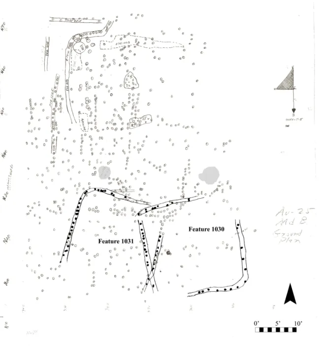
Feature 1030. This structure was square in shape with wall trenches that had closed
corners on at least two sides. The structure measured 22.7 feet on a side, with postmolds a median 6.1 inches in diameter. Postmolds were spaced a median 11.3 inches apart. Given a lack of evidence for any interior features, including roof supports, this building was likely of bent-post construction, given relatively narrow bent-posts and spacing within one foot. . The date of the structure is uncertain, as with most features at this site. There was not evidence of a hearth within the structure. A pot, filled with refuse upon excavation, Feature 1043, was dug right outside the structure and may be associated (Whitmer 1987:Table 16).
Feature 1031. This structure, also nearly square in shape, was built after Feature 1030, as
it intruded upon the other structure’s wall trench to the east. This structure was of similar size to Feature 1030, measuring 21.2 feet in one direction and an estimated 21 feet in the other (this dimension, about north-to-south, is unclear, as the southern wall of the structure does not survive). Postmolds were set within wall trenches with widths an average 5.7 inches across and spacing averaging 6.9 inches. These metrics, which indicate similarities to Feature 1030, strongly indicate bent-post construction. A pit (Feature 1039) also lies just outside of this structure
(Whitmer 1987:Table 16), and, being at about the same elevation, may be associated.
Village
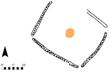
uncovered. As a result, I can only provide a description of the shape, dimensions, and presence or absence of a wall trench for the structures found in this part of the site. Structures mostly appeared to be bent-post in construction, because each appeared to feature relatively small postholes closely spaced about an interior that featured no sign of support posts. Except in places where structures intrude, it is difficult to understand the relative chronology of each structure’s construction, and, without greater analysis of the site’s ceramics, it is difficult to place the structures within an absolute time of construction. Two hearths (fire basins) were found at the periphery of the structures, along with a variety of pit features.
Feature 45. This structure was open-cornered and square. It featured wall trenches and
had dimensions of about 23 by 21 feet.
Feature 167. This was an open-cornered square structure with wall trenches, with
dimensions about 21 by 18 feet. A pit is closely associated to the west.
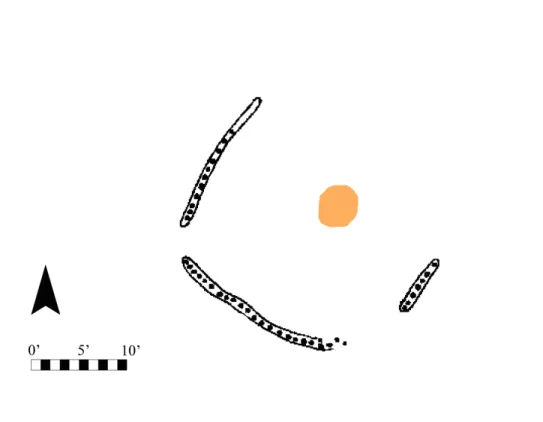
Feature 169. This structure was an open-cornered square structure with wall trenches,
with dimensions about 23 by 22 feet. It intrudes upon the north of Feature 167. Image analysis of the low quality map resulted in a tentative post diameter of 14.56 inches. This was found to be outlandishly high for such a small structure with closely spaced posts (evident from the map). Given the imprecision inherent in the low-resolution image, further image analysis was foregone. Because the resolution was so small that it was impossible to precisely differentiate between each individual postmold within the wall trench of this structure, analysis of median postmold spacing was not attempted. A pit is overlies part of the southern wall trench and therefore postdates the structure.
Feature 427a. This was a circular wall trench structure with a diameter of about 28 feet.
Depending on the chronology of construction, it may be associated with a pit to the south.
Feature 427b. This was a circular wall trench structure (the wall trench was partially
Feature 514. This was a circular wall trench structure with a diameter of about 22 feet.
Feature 515. This was a wall trench that intruded upon Features 514 and 516, and
connects to the wall trench of Feature 517. Interpretation of this feature is impossible without more information.
Feature 519. This was a circular wall trench structure with a diameter about of about 29
feet, which circumscribed Feature 514. The wall trenches of the structure overlap on the east end.
Feature 517. This was a square wall trench structure with closed corners and dimensions
about 25 by 24 feet.
Feature 540. This was a circular structure with no distinguishable trace of a wall trench.
It measured about 27 feet in diameter. Within the structure is a pit feature.
Feature 1296. This was a rectangular wall trench structure with closed corners (two are
apparent). It seems to have been intruded upon by another wall trench structure in the north wall. The wall trench was not found on the southeastern wall of the structure, and the western wall was barely evident. It had approximate dimensions of 29 feet by 24 feet.