Developing Road Infrastructure Route Planning:
Increasing Feasibility of Toll Road Project
Mohammed Ali Berawi
1*, Teuku Yuri Zagloel
1, Perdana Miraj
1,2, AbdurRohim Boy Berawi
1,
Wellsi Titaheluw
1, and Saipol Bari Bin Abd Karim
31. Department of Civil Engineering, Faculty of Engineering, Universitas Indonesia, Depok 16424, Indonesia 2. Department of Civil Engineering, Faculty of Engineering, Universitas Pancasila, Jakarta 12640, Indonesia
3. Department of Quantity Surveying, Faculty of Built Environment Building, University of Malaya, 50603 Kuala Lumpur, Malaysia
*e-mail: [email protected]
Abstract
Indonesian government attempts to improve connectivity and to increase regional activities in Sumatera Island through the development of Trans Sumatera Toll Road (TSTR). However, despite its benefits to local economic development in Sumatera, the project shows low feasibility due to a low amount of investment. It can be attributed from the lack of planning in the initial phase to produce a comprehensive route that considers the various potentials of the regions. Thus, this research aims to investigate alternative route planning of Trans Sumatera Toll Road particularly in this paper for Central Sumatera by studying Gross Regional Domestic Product (GRDP), population and other significant factors. This research exposes cities and districts in Riau, West Sumatera, and Jambi which potentially contribute to the regional economy. Each selected towns and districts will be integrated with the intermodal system and connected to other functions to establish the Trans Sumatera Toll Road project in Central Sumatera. Compared to existing estimation of investment from public records, this alternative route has generated a competitive cost of investment which is estimated around 118,053,400,074,696 rupiahs. The research findings are expected to become the basis to improve other similar infrastructure toll road project development.
Abstract
Pembangunan Perencanaan Rute Infrastruktur Jalan: Meningkatkan Kelayakan Proyek Jalan Tol. Pemerintah Indonesia berupaya untuk meningkatkan konektivitas dan meningkatkan kegiatan ekonomi regional di Pulau Sumatera melalui pengembangan Jalan Tol Trans Sumatera (JTTS). Namun demikian, proyek tersebut masih menunjukkan kelayakan rendah yang disebabkan minimnya kelayakan investasi. Hal ini disebabkan kurangnya perencanaan pada tahap awal proyek dalam menghasilkan rute komprehensif dengan mempertimbangkan berbagai potensi daerah. Dengan demikian, penelitian ini bertujuan untuk menghasilkan perencanaan rute alternatif Jalan Tol Trans Sumatera (JTTS) khususnya Sumatera bagian tengah. Hal ini dilakukan dengan mempelajari Produk Domestik Regional Bruto (PDRB), populasi dan faktor signifikan lainnya. Penelitian akan menghasilkan kota dan kabupaten di Riau, Sumatera Barat dan Jambi yang potensinya diintegrasikan dengan sistem intermodal dan terhubung dengan fungsi lain pada proyek JTTS bagian Sumatera Tengah. Dibandingkan dengan estimasi biaya yang tercatat dalam catatan publik, rute alternatif ini menghasilkan biaya yang kompetitif yang mencapai 118.053.400.074.696 rupiah. Luaran penelitian diharapkan dapat digunakan sebagai dasar untuk pengembangan proyek infrastruktur lain di Indonesia.
Keywords: case study, feasibility, Indonesia route planning, toll road
1. Introduction
Sumatera is one of the major islands in Indonesia with abundant natural resources which are potentially generated for the people wellbeing. The important role of Sumatera can be seen from its gross regional domestic products that are placed at the second biggest contributor for the nation with 23.90% [1].
The toll road aims to make seamless traffic in developing areas, improve services in terms of logistic distribution and support economic growth [2]. It also plays a significant role to create job opportunity [3], increase local natural resources, encourage investment and trigger economic activities [4]. Infrastructure will accelerate people and goods mobility with multiplier effects for national economic growth.
Trans Sumatra Toll Road has been planned to stretch from the very north of Sumatera Island in Aceh province to the very south in Lampung province for about 2,788 km, and it is estimated about 340 trillion rupiahs. The research was conducted for the whole route of Trans Sumatera Toll Road [5,6] and this paper’s analysis will focus on the Central Sumatera route planning.
In the context of this paper, Central Sumatera will stretch along Riau, West Sumatera, and Jambi for about 1,150 km and it is estimated to require 143 trillion rupiahs in the period of 2012 [7]. As the investment cost is enormous, the comprehensive study shall be conducted to create robust route selection for the project.
This research will produce alternative route selection by considering various aspects, such as gross regional domestic product (GRDP) for the three provinces, population and featured sectors that can be developed in each city and regencies. The result also generates other functions that are expected to increase the value of Trans Sumatera Toll Road project development.
The research findings also expected can be used as a recommendation for the government and other related stakeholders to create more effective and efficient route planning for Trans Sumatera Toll Road.
2. Methods
This study comprises three stages to achieve the research objectives. Firstly, secondary data were gathered from various sources, such as journals, reports, government policies, and regulations in terms of economic perspectives and domestic population. It aims to provide local features which may be used for toll road route selection. Second, initial costs from the identified route will be investigated through similar toll road project development by con-sidering the topography. It is represented by rupiah per km. The Mountain section will use Kelok 9 in West Sumatera, the Hills section uses Cipularang Toll Road in West Java, the Flatland section uses Kanci – Pejagan Toll Road in West Java, and the Bridges will use Cipada Bridge construction costs [12].
All costs have been converted to the period of 2016 by considering inflation and construction cost index. Evaluation of the proposed route is conducted for its topography and the length to produce the construction
cost only for the toll road (single function). Furthermore, multi – function is defined as the project which serves more than one function for the users. Additional function costs are determined with the similar approach where the construction costs are processed through a benchmarking process.
Last, potential sectors from cities and regencies along the designated route will be determined using the location quotient method. It is expected from those sectors to be able to support regional economy and act as a trigger to use the infrastructure.
Location Quotient method is used to compare the gross regional domestic products (GRDP) of a particular sector/production in a region to GRDP of the overall sector in the region [8,9]. The concept can be visualized in the following formula.
E i E
e i e
i
LQ (1)
Where:
LQi = LQ value for i sector in a district ei = GRDP for i sector in a district e = GRDP whole sector in a district
Ei = GRDP sector i in the province of the district E = GRDP whole sector in the province of the district
LQ will produce coefficient from 0 to immense value. LQ < 1 means the commodity sector in that region has no comparative industrial cluster. LQ = 1 indicates that there is no distinguished feature from one region to another. LQ > 1 shows the investigated sector has a related industrial sector [10,11].
3. Results and
Discussion
Route selection. The route selection that considers GRDP and population produces Bengkalis, Pekanbaru, RokanHilir, Kampar, and Indragiri Hilir as cities/regencies that will be connected by Trans Sumatera Toll Road. Bengkalis has the most significant GRDP (Table 1). Although this regency has low population, its natural
Table 1. GRDP and Population Ranking in Riau Province
City/Regency Ranking
GRDP* Population
Bengkalis 28,038,005 -
Pekanbaru 12,009,280 998,901
RokanHilir 11,672,760 618,179
Kampar 10,762,640 766,232
Indragiri Ilir - 685,530
resources which are distributed to the processing industry in another area might play a significant role in increasing toll Road occupancy.
East – West route to West Sumatera province will pass through the Kampar regency. It ranks 4th for GRDP and 2nd in population for Riau province. Thus, this regency has potential in terms of people and goods mobility as well as production and purchasing power. Meanwhile, North – South route to Jambi province will pass through Indragiri Hilir regency with the potential population rank for the 3rd in Riau province.
Besides, the course also considers Dumai in western part as it has Dumai Port. It will act as intermodal transportation from road to port and it is expected to increase this project added value. The route from Riau Province is shown in Figure 1.
On the other hand, Trans Sumatera Toll Road in West Sumatera province will pass through several cities and regencies. Lima Puluh Kota, Agam, Padang Pariaman, and Padang City are the most contributors in terms of GRDP for West Sumatera province. When connected to Lima Puluh Kota and Agam regencies, two potential cities that also gain benefits from Trans Sumatera Toll Road are Payakumbuh City and Bukittinggi City. The comparison of GRDP and population in West Sumatera province can be seen in the following table.
Figure 1.Riau Province Route Selection
Table 2. GRDP and Population Ranking in West Sumatera Province
City/Regency Rangking
GRDP* Population
Padang 14,516,680 876,678
Agam 3,725,540 466,978
Pdg. Pariaman 3,454,100 400,890
Lima Puluh 3,421,654 -
Pes. Selatan - 440,740
*(In million)
Considering the cities and regencies that potentially connect Trans Sumatera Toll Road, the following figure shows the visualization of the route in West Sumatera province (Figure 2).
Route development of Trans Sumatera Toll Road in Jambi province connects Muaro Jambi, City of Jambi, Tanjung Jabung Timur, and Tanjung Jabung Barat. This rational considers that both Jabung Timur and Tanjung Jabung Barat serve as the highest GRDP for Jambi province. Nevertheless, the city of Jambi and Muaro Jambi Regency are two largest contributors in terms of population.
Therefore, the route of Jambi province from North – South line started from South Sumatera then Muaro Jambi Regency, the city of Jambi, Tanjung Jabung Timur, and Tanjung Jabung Barat consecutively. The following figure will visualize the route selection in Jambi province (Figure 3).
Initial cost. The initial cost of the project reflects other road projects that share similar topography. As the inflation and construction cost index are taken into account, therefore the rupiah/km in each province is different. For instance, the cost of flatland in Riau requires 103 million rupiahs/km. On the contrary, Jambi and West Sumatera have lower construction cost for about 98 million rupiahs and 90 million rupiahs per km respectively. The detail of adjusted costs for each province is determined as follows (Table 4).
Figure 2.West Sumatera Province Route Selection
Table 3. GRDP and Population Ranking in Jambi Province
City/Regency Ranking
GRDP* Population City of Jambi 3,929,213 569,331 Tanjung Jabung Timur 2,814,658 - Tanjung Jabung Barat 2,689,535 -
Bungo 1,521,740 329,934
Muaro Jambi - 376,619
Merangin - 358,561
*(In million)
Legends:
Existing Route
Proposed Route
Legends:
Existing Route
Computational software calculates the slope of the route prior to estimate the cut and fill cost. The result identifies the length and type of topography for each province. The total for construction costs of this project is estimated about 114,982,766,899,458 rupiahs.
Compared to the existing concept where the project only develops for the only toll road, this research produces several additional functions (Table 5). It comprises of the dry port in Pekanbaru, the use of railway in Pekanbaru – Dumai section for about 137,263 km, fiber optic in Pekanbaru for about 193,409 km, as well as service and the rest area in selected locations. The total amount for four additional functions is forecasted around 3,070,633,175,238 rupiah.
As the total of Trans Sumatera Toll Road project that considers toll road and its additional functions, such as dry port, railway integration, fiber optic, and rest area; thus, the forecasted initial cost is about 118,053,400,074,696 rupiah. Mapping of other functions in Central Sumatera can be seen in the following Figure 4.
Figure 3. Jambi Province Route Selection
Location quotient. Following the use of Location Quotient method to compare GRDP for each city and regencies that connect the Trans Sumatera Toll Road, the potential featured sector for three provinces then can be identified.
In Riau province, the featured sector is mostly contributed from mining and quarrying, agriculture, trading as well as services. Meanwhile, West Sumatera province depends on agriculture for their featured sector, followed by trading, hotels, and restaurants. Last, Jambi also shows dependency into agriculture for its featured sectors, then followed by mining and quarrying, and processing industry.
Regencies in Riau province have the highest GRDP compared to others in Central Sumatera region. For instance, Kampar regency as the 4th rank in GRDP has about 10,762,640,000,000 rupiahs which is greater than the 1st position in Jambi province with only 3,929,213,000,000 rupiahs and also the 2nd rank in West Sumatera province with 3,725,540,000,000 rupiahs. It is
Figure 4. Mapping of Additional Functions in Trans Sumatera Toll Road in Central Sumatera
Table 4. The Detail of Adjusted Costs for each Province
Table 5. Additional Function Costs
Additional Functions Length Cost (Rp.)
Dry port - 929,145,068,000
Railway Integration/Km 137,263 8,431,641,522
Fiber Optic/Km 193,409 51,171,186,175
Service and Rest Area - 2,081,885,279,541
Type of Topography Riau
(Billion Rp./km)
Jambi (Billion Rp./km)
West Sumatera (Billion Rp./km)
Flatland 103.59 98.89 90.58
Hills 106.87 102.02 93.45
Mountain 521.33 497.69 455.88
Bridge 495.80 473.31 433.56
Legends:
Existing Route
expected that from the construction of toll road in the central region of Sumatera, other cities and regencies will be able to improve its connectivity and mobility both for the people and for the goods as high as the Riau province.
The government through the Ministry of Public Works previously generated the route for Trans Sumatera Toll Road from Lampung in the southern part of Sumatera to Aceh in the north part of Sumatera. For central Sumatera region in 2012, the forecasted toll road construction required 172,152,933,016,192 rupiahs. In this research, those costs were converted into the 2015 period through the cost construction index and inflation. It will be compared to a single function and multi – functions from the research output (Table 6).
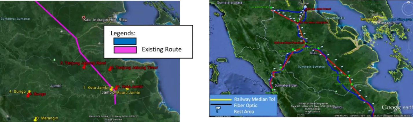
This research has a different direction in Riau province in section Lankobangkuang – Duri – Dumai. The existing route passing through Langkobangkuang – Dumai – Duri stretches for about 250 km. Meanwhile, the proposed route connects Dumai from Duri creates Y-shaped as shown in Figure 5. This selected route can minimize the length of the route into 161.85 km.
This route selection reduces the construction costs significantly for about 56.79% from 30,158,027,660,109 rupiahs to 17,126,759,589,482 rupiahs. Other costs which contribute to the differences between existing route and proposed route are predicted from technical and financial consideration from both calculations. Table 6. Construction Cost Comparison between the
Government and the Proposed Route
Route Construction Costs
in 2015 (Rp.)
Government 172,152,933,016,192
Proposed Route (Single function) 114,982,766,899,458 Proposed Route (Multi-function) 118,053,400,074,696
Figure 5. Comparison of Existing Route (Blue) and Proposed Route (Pink)
As the total, the proposed route create cost efficiency for about 33.21% in a single function and 31.43% in multi functions compared to the existing route. These findings are aligned with similar research by other researchers [13,14,15] that agrees that having better connectivity will stimulate regional's economic growth and furthermore, and creating multi functions infrastructure produces optimum benefits for stakeholders [2,4,5].
LQ analysis in Riau province shows that the mining and quarrying are playing a significant role for the local economic activities. This result is supported by the prospective growth of GRDP where this province ranked as the 5th highest in Indonesia and 1st in Sumatera Island. Moreover, Investment Corporation in Riau is dominated by infrastructure, agriculture, pulp, and paper where 900 companies contribute to the local economy [16]. Although the quantity of mining and quarrying companies is relatively lower than other sectors, they also have a major role in terms of economic growth involvement. According to Gross Regional Domestic Products at 2000 Constant Market Price by Industrial Origin Including Oil and Gas [17], it has the highest value amongst other sectors for about 47,606,738.84 million rupiahs.
On the other hand, West Sumatera depends their economic activities on the agriculture sector, such as raw foods, crops, and fishery. According to Gross Regional Domestic Products at 2000 Constant Market Price by Industrial Origin including Oil and Gas of West Sumatera [18], the sector contributes about 21% to the province GRDP then followed by trading, hotels, and restaurants; and services for 18.48% and 17.46% respectively. The local government currently initiates deregulation and seamless coordination among institutions to improve investors' attractiveness, while the central government supports in terms of promotion, regulation, and policies through related ministries such as the Ministry of Trade, Investment Coordinating Board, and others.
Compared to Riau and West Sumatera provinces, Jambi contribution to the national GDP is fairly low. Most of the province contributes from the agriculture sector (28.25%), particularly annual crops followed by mining and quarrying for about 19.00%. The investment for Jambi province is considered short. It is suggested that the local government accelerates deregulation and coordinates with the central government to promote the agricultural sector. Collaboration with processing industries in Sumatera Island is also part of the option to increase Jambi’s economic activities.
4. Conclusions
Jambi, Tanjung Jabung Timur, Tanjung Jabung Barat and Kota Baru Reteh for Jambi Province then followed by Teluk Kiambang, Pangkalan Kerinci, Pekanbaru, Duri – Dumai and Duri – Langkobangkuang. Moreover, West Sumatera Province is connected from Pekanbaru to Kampar in Riau then Bangkinang, Payakumbuh, Agam, Padang Pariaman, and city of Padang.
Initial costs for toll road as a single function only for transportation require for about 114,982,766,899,458 rupiahs. Furthermore, multi-functions with intermodal transportation of Trans Sumatera Toll Road produce 118,053,400,074,696 rupiahs of investment. Both single and multi–functions reduce construction costs for about 33.21% and 31.43% respectively.
The featured sector in Central Sumatera region ranging from mining and quarrying as well as agriculture. It is suggested to consider multiplier effects from the toll road to regional economic development, particularly in these sectors.
Acknowledgement
This research is fully supported by research grants from Universitas Indonesia and the Ministry of Education of the Republic of Indonesia. Grant No: 1012/UN2.R12/ HKP.05.00/2016
References
[1] Statistical Yearbook of Indonesia, (2015).
[2] M.A. Berawi, A.B. Berawi, I.S. Prajitno, Nahry, P. Miraj, Y. Abdurachman, E. Tobing, A. Ivan, Int. J. Technol. 6/4 (2015) 679.
[3] E. Meijers, J. Hoekstra, M. Leijten, E. Louw, M. Spaans, J. Transport Geogr. 22 (2012) 198. [4] M.A. Berawi, B. Susantono, P. Miraj, A.B. Berawi,
H.Z. Rahman, A. Husin, Procedia Technol. 16 (2014) 1046.
[5] M.A. Berawi, T.Y. Zagloel, A.B. Berawi, Y. Abdurachman, Int. J. Technol. 6/3 (2015) 399. [6] M.A. Berawi, T.Y. Zagloel, P. Miraj, H. Mulyanto,
Sustainable Civil Engineering Structures and Construction Materials (SCESCM) Conference, Bali, 2016.
[7] Ministry of Public Works, Trans – Sumatera Toll Road Report Plan, Jakarta, 2012.
[8] K. Morrissey, Ocean Coastal Manage. 91 (2014) 64.
[9] A.J.C. Trappey, C.V. Trappey, P.H.Y. Liu, C.T. Hsiao, J.J.R. Ou, K.W.P. Chen, Concurrent Engineering Approaches for Sustainable Product Development in a Multi-Disciplinary Environment, Proceedings of the 19th ISPE Internasional Conference on Concurrent Engineering, Springer London, 2013, p.377.
[10] Y-F. Wang, X. Jiang, Issues For. Econ. 6 (2012) 005.
[11] S.B. Billings, E.B. Johnson, Reg. Sci. Urban Econ. 42/4 (2012) 647.
[12] Ministry of Public Works, Unpublished Report, 2015.
[13] P. Sahoo, R.K. Dash, J. Int. Trade Econ. Dev. 21/2 (2012) 252.
[14] R.P. Pradhan, T.P. Bagchi, Res. Transp. Econ. 38/1 (2013) 148.
[15] A. Ansar, B. Flyvbjerg, A. Budzier, D. Lunn, Oxford Rev. Econ. Policy. 32/3 (2016) 390. [16] Investment Coordinating Board, Local and Foreign
Investment in Riau Province, Indonesia, 2015. [17] Statistics Indonesia, Gross Regional Domestic
Products at 2000 Constant Market Price by Industrial Origin including Oil and Gas in Riau Province, Indonesia, 2016.