A quantitative method for evaluating the importance
of marine areas for conservation of birds
Henrik Skov
a,*, Jan Durinck
b, Mardik F. Leopold
c, Mark L. Tasker
d aDHI Water and Environment, Agern Alle 5, DK-2970 Hørsholm, Denmark bMarine Observers, Svankjaervej 6, DK-7752 Snedsted, Denmark
cWageningen-IMARES, P.O. Box 167, Landsdiep 4, NRL-1797 SZ Den Hoorn (Texel), The Netherlands dJoint Nature Conservation Committee, Dunnet House, 7 Thistle Place, Aberdeen AB10 1UZ, United Kingdom
A R T I C L E I N F O Article history:
Received 19 February 2006 Received in revised form 3 December 2006
Accepted 6 December 2006
Keywords:
Marine classification criterion Seabirds
Marine protected areas Identification of concentrations
A B S T R A C T
Objective criteria are needed for ranking marine sites when examining candidate areas for protection measures. We suggest a Marine Classification Criterion (MCC) which allows the application of the widely used Ramsar 1% criterion for wetlands for seabirds with clustered distribution in offshore habitats. The maximum size of an area considered to be interna-tionally important has not been defined by the Ramsar Convention. Terrestrial and coastal sites generally have obvious hydrological or physical boundaries, whereas such boundaries are less obvious at sea. The smallest unit which would pass the demands set by the MCC is 1% of the bio-geographic population of a particular species concentrated in an area (site) supporting a density exceeding a value equivalent of four times the average density of the species in the investigated regional sea. The effect of choosing smaller or larger refer-ence densities is tested. The results indicate that the chosen threshold density is a suitable requirement for the inclusion of the most important areas for seabird species with at least 25% of their bio-geographic population occurring in the studied regions of the North Sea and the Baltic Sea. The test cases indicate that provided the MCC is based on geo-statistical analyses of un-biased survey data the boundaries of areas holding large concentrations of seabirds can be estimated with confidence. The MCC could be used to identify concentra-tions of seabirds and other marine animals of conservation priority and to rank marine areas by their cumulative importance to different species.
Ó2007 Elsevier Ltd. All rights reserved.
1.
Introduction
The IVth World Congress on National Parks and Protected Areas held in Caracas, Venezuela, in 1992 (IUCN, 1993), high-lighted the need for protected areas in marine as well as ter-restrial environments in order to conserve biodiversity. In the following years, scientifically-based methods (e.g. gap and complementarity analysis) for prioritising conservation ef-forts have been developed and tested (Fjeldsa˚ and Rahbek,
1998; Williams, 1998). It has, however, been difficult to define important marine areas, and relatively few marine protected areas and integrated marine management zones exist today. The lack of obvious boundaries, of quantitative information and of jurisdiction has hampered the designation of areas for conservation in offshore habitats. This paper discusses the problems related to identifying and delineating areas for conservation for seabirds, and it proposes a procedure which ranks the conservation value of different marine areas for
0006-3207/$ - see front matterÓ2007 Elsevier Ltd. All rights reserved. doi:10.1016/j.biocon.2006.12.016
*Corresponding author:Tel.: +45 45169220; fax: +45 45169292.
E-mail addresses:hsk@dhi.dk(H. Skov),jan@durinck.dk(J. Durinck),Mardik.Leopold@wur.nl(M.F. Leopold),Mark.Tasker@jncc.gov.uk (M.L. Tasker).
a v a i l a b l e a t w w w . s c i e n c e d i r e c t . c o m
seabirds based on existing quantitative criteria for selecting areas of international importance while taking the size of the areas into consideration. The method is applicable to all organisms for which reliable regional density and population estimates exist, but seabirds were chosen to illustrate the pro-cedure, as these are highly visible organisms for which rela-tively much information is available.
Over the last 15 years, scientifically-based methodologies for identifying and prioritising conservation areas have been developed. These methods define target areas based on spe-cies diversity or rarity, such as analyses of hotspots (Myers, 1990; ICBP, 1992) or more elaborately in analyses of comple-mentarity (Vane-Wright et al., 1991; Fjeldsa˚ and Rahbek, 1998; Williams, 1998). However, these criteria may not be use-ful measures of the potential of sea areas for the conservation of birds, as large numbers of birds can be concentrated in spe-cies-poor marine seascapes such as estuaries and upwelling areas (Summerhayes et al., 1974).Kelleher and Kenchington (1992) proposed a set of general, qualitative criteria to be used for the selection of marine protected areas, but paid no atten-tion to the specific conservaatten-tion requirements of seabirds. Full, effective protection of widely ranging animals like sea-birds needs the co-operation between several countries.
Site-based conservation of birds has a long history in ter-restrial, limnic and coastal ecosystems, and has played an important role in the development of today’s networks of pro-tected areas worldwide. The overarching goal of site-based conservation of birds has been to identify those sites that are exceptionally important for birds at some period during the year, – ones of significance both nationally and interna-tionally, and to try to ensure the conservation of the features that make these areas important. Examples of site-based bird protection systems are the EU network of Special Protected Areas (EU Birds Directive, 1979) and the global series of Impor-tant Bird Areas proposed by BirdLife International (Heath et al., 2001). Quantification of the importance of coastal and inland wetland areas for birds has long been based on a widely agreed set of international criteria under the auspices of the Convention on Wetlands of International Importance especially as Waterbird Habitat (the Ramsar Convention). To be considered internationally important for waterbirds, a wetland site has to meet any one of two criteria (Ramsar Con-vention Bureau, 1988):
1. It regularly supports 20,000 waterbirds.
2. It regularly supports 1% of the individuals in a population of one species or subspecies of waterbird.
The 1% criterion has been particularly useful because it is comparatively easy to count waterbirds, and thereby derive both site counts and global population estimates. There is no biological reason to use 1% of a population as the thresh-old level for establishing international importance of a site. However, this percentage has gained wide acceptance and we see no reason to challenge it. The size of an area consid-ered to be internationally important is, however, not defined. A larger site is by definition likely to contain more birds than a smaller site centred around the same location. Terrestrial and coastal sites generally have obvious hydrological or physical boundaries, whereas such boundaries are less obvious for
marine sites. Another restriction for the application of the Ramsar Convention criteria to the open sea is that ‘wetlands’ are limited to areas that are no deeper than 6 m. Despite these limitations, selection of conservation areas for birds by the application of the Ramsar criteria has taken place in truly marine areas, e.g. EU Special Protection Areas and Ramsar sites in the Danish part of the Kattegat (Jensen, 1993). Other approaches for selection of priority areas for conservation of birds in marine waters include seaward extensions of nation-ally and internnation-ally important breeding colonies (e.g. United Kingdom;Johnston et al., 2002), habitat features related to na-tional marine sanctuary systems (e.g. Stellwagen Bank, USA; http://sanctuaries.noaa.gov/) or analyses of tagging data (e.g. Birdlife International’s ‘‘Ocean Wanderers’’ project (BirdLife International, 2004).
The use of the 1% criterion requires the availability of esti-mates of total population size as well as estiesti-mates of the
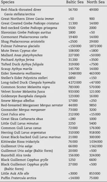
Table 1 – Total estimates of selected seabird species wintering in the Baltic Sea and the North Sea (1987–1995)
Species Baltic Sea North Sea
Red-/black-throated diver
Gavia stellata/arctica
56 700 49 000 Great Northern DiverGavia immer <50 900 Great Crested GrebePodiceps cristatus 11 300 14 000 Red-necked GrebePodiceps grisegena 5500 2000 Slavonian GrebePodiceps auritus 1800 <50
CormorantPhalacrocorax carbo 19 400 14 000
ShagPhalacrocorax aristotelis <2500 29 000 FulmarFulmarus glacialis <150 000 1872 000
Mute SwanCygnus olor 108 000 <1800
MallardAnas platyrhynchos 227 000 <50 000
PochardAythya ferina 31 200 <3500
Tufted DuckAythya fuligula 319 000 <7500
ScaupAythya marila 145 700 14 000
EiderSomateria mollissima 1 048 000 463 000
Steller’s EiderPolysticta stelleri 6850 <150 Long-tailed DuckClangula hyemalis 4 272 000 <47 000 Common ScoterMelanitta nigra 783 000 570 000 Velvet ScoterMelanitta fusca 933 000 121 000
GoldeneyeBucephala clangula 123 000 16 000
SmewMergus albellus 17 000 <250 Red-breasted MerganserMergus serrator 44 000 9850
GoosanderMergus merganser 73 000 3200
CootFulica atra 212 000 <15 000
Great SkuaCatharacta skua <280 1000
Little GullLarus minutus 2250 5400
Common GullLarus canus 72 000 176 000
Herring GullLarus argentatus 310 000 918 000 Great Black-backed GullLarus marinus 21 000 300 000
KittiwakeRissa tridactyla 76 000 1 034 000
GuillemotUria aalge 66 000 1 562 000
GuillemotUria aalge(Baltic form) 20 000 <500
RazorbillAlca torda 156 000 324 000
Black GuillemotCepphus grylle 1250 6600
Black GuillemotCepphus grylle
(Baltic form)
27 000 <500
Little AukAlle alle <3000 853 000
PuffinFratercula arctica <14 000 75 000
Estimates are only mentioned for species occurring in the relevant region in numbers exceeding 1% of the reference biogeographic population.
number of birds of the particular species in the studied area. Population estimates for waterbirds inhabiting coastal envi-ronments have recently been reviewed (Wetlands Interna-tional, 2002), while those for pelagic species of seabirds vary from estimates with confidence limits to educated guesses. Estimates of numbers of birds offshore and their distribution are now becoming available through large-scale surveys using line transect techniques (Tasker et al., 1984; Webb and Dur-inck, 1992). Due to the wide range of marine habitats occupied by birds it is frequently necessary to merge data from multi-ple sources (e.g. counts from land, ships, aeroplanes) in order to obtain a complete description of birds using an area based on unbiased population estimates (e.g.Skov et al., 1995).
2.
Materials and methods
2.1. Study regions and survey data
This paper is based on European work, but the concept should be applicable to all offshore marine areas including oceanic and shelf seas, coastal zones and archipelagos. The method-ology has gradually been developed and tested during a large number of projects from feasibility studies in relation to mar-ine conservation areas within the European Union (Durinck et al., 1994), to analyses of marine important bird areas (Skov et al., 1995, 2000) to designation of potential EU Special Pro-tection Areas (SPAs,Johnston et al., 2002; ICES, 2006). In this paper, the selection procedures used in Skov et al. (1995, 2000) have been refined and updated in order to strengthen their general application. The revised selection procedures have been tested on an international seabird database (ESAS, European Seabirds at Sea database) containing winter distri-butions of waterbirds for the Baltic Sea and year-round sea-bird distributions for the North Sea at large (Stone et al.,
1995). Although the surveys contained in the ESAS database were not specifically designed for this analysis, the use of it made it possible to test the methods on a large, basin-wide database that includes seabird densities in virtually all types of habitats, including all coastal environments. The ESAS data used here were collected by many observers between 1987 and 1995 (1993 in the Baltic Sea) using standard methods ( Tas-ker et al., 1984). Although more recent data have been col-lected in the two regions, comprehensive coverage of both regions was only achieved during the described period. All data collected under relatively calm conditions (Beaufort sea state64) were processed to describe seabird distributions in the Baltic Sea during winter and in the North Sea during the whole year. Approximately 150,000 km of line transect observations is represented in the data used for analysis. In addition to offshore line transect data, information was ob-tained from national databases on birds in near-shore waters during the same periods. These data mainly cover observa-tions made from aerial or land-based surveys in connection with the internationally co-ordinated Wetlands International Midwinter Census of waterbirds. Information on numbers of birds presumed to be associated with the breeding colonies of seabirds in the region were derived from the United King-dom Seabird Colony Register (Lloyd et al., 1991), Grimmett and Jones (1989) and Ha¨lterlein and Steinhardt (1993). No extrapolation from these numbers into waters surrounding the breeding colonies took place.
The distributions of the 30 most common species have been analysed. Some species of seabirds are best surveyed by one type of platform (e.g. aeroplane) while the distribution of others may best be described using a combination of meth-ods from several platforms. Thus, in order to achieve reliable figures for the entire seabird fauna all data were combined using a Geographical Information System (GIS) to produce
integrated maps of bird numbers per unit area. The procedure implied integration of densities obtained from aerial and ship-based line transects with densities converted from total counts (land-based and aerial total counts). Densities were converted from total counts in near-shore areas by assuming a detection range of 1 km during these counts. Densities ob-tained during aerial and different types of ship-based line transects were standardised using correction factors for birds missed in the searched area determined from estimated detection probabilities in the software Distance (http:// www.ruwpa.st-and.ac.uk/distance/).
Comparison of the total numbers of all species of sea-birds occurring in the whole Baltic Sea and the North Sea was made for the winter season (December–February). Dur-ing winter the total number of seabirds in the two regions is of the same order of magnitude (106), but the communities are clearly different (Table 1). The Baltic avifauna is domi-nated by benthic-feeding species (diving ducks), while in the North Sea rather more pelagic-feeding species are dom-inant (fulmar, gannet, gulls and auks). Hence, the two study areas provided a wide range of different habitats to test the criteria on.
Fig. 2 – Example variogram (spherical) used for description of spatial variance for black guillemot (Cepphus grylle) in the Baltic Sea.
Fig. 3 – The effect of choosing different degrees of concentration reflected by density levels on the classification of areas of importance to seabirds in the North Sea (a and b) and the Baltic Sea (c and d). The four graphs show the proportion of the total estimated number of birds at sea covered by the classified areas in the two regions as determined by increasing minimum densities from 2 to 7 times the average regional density of the species in question. The species selected are species for which at least 25% of the total biogeographic population are estimated to occur in the North Sea and the Baltic Sea. In the North Sea, the season has been chosen in which the largest number of birds in the region was found.
2.2. Identification of concentrations
Different species of seabirds show different degrees of cluster-ing within their preferred habitats dependcluster-ing on the scale analyzed. Aggregating seabirds typically occur in few large patches or more commonly in multiple smaller patches. In this study the spatial variation of each species was analysed by applying b-spline approximation techniques (North Sea, see Skov et al., 1995 for details) and interpolations (Baltic Sea, seeSkov et al., 2000for details) using kriging to the data-base of integrated densities from all survey platforms, see (Fig. 1). In the case of multiple patches, our study shows that gradients are found in the density between strata marking the background density of birds and strata in which patches of birds occur frequently at short relative intervals (extended aggregations). The preferred scientific method for stratifying areas of different densities of birds is fine-scale geo-statistical analyses (kriging) and interpolation of sampled densities by application of experimental variograms (Cressie, 1991). The use of variograms allows for a model-based determination of the scale of spatial autocorrelation (variogram range), which can be used to inform about the chord length of extended aggregations. In the analysis of the Baltic Sea the range was also used to set the maximum distance of extrapolation away
from sample points. In this way the obvious danger of using arbitrary borders, e.g. by expanding an area until numbers within it reach 1%, was avoided. Further, the use of variograms as a basis for kriging made it possible to determine nugget ef-fects and the orientation of anisotropies in the data. For most of the species of conservation concern (i.e. divers, grebes, sea-ducks and auks) radial and spherical variograms fitted best to the sampled data, and strong anisotropies were apparent. A sample variogram is depicted inFig. 2.
2.3. Identification of important areas per species – the
Marine Classification Criterion (MCC)
Geo-statistical analyses of the distribution of a seabird spe-cies can be coupled with two further parameters to determine the importance of an area holding an aggregation of that spe-cies: the percentage of the bio-geographic population of the bird living within the area and the degree of concentration displayed by the aggregation. Due to characteristic pattern of dispersal of many of the key marine bird species in the two sea regions (species with more than 25% of the bio-geo-graphic population occurring in either region), only a small number of areas can be considered as of high importance to seabirds and thus the target of conservation efforts. In the
Fig. 4 – Sketch of the GIS-procedure for merging boundaries of selected species areas into priority multi-species polygons. The example is from Pomeranian Bay showing nine species areas meeting the MCC being merged into the multi-national priority area for conservation marked with a blue line. EEZ boundaries for Germany, Poland and Denmark are indicated.
North Sea, the six most important areas together account for 80% of the estimated total importance of areas to seabirds (Skov et al., 2000), and in the Baltic Sea the ten most impor-tant areas, covering less than 5% of the Baltic Sea area, host about 90% of the total estimated number of wintering sea-birds in the region (Durinck et al., 1994). Accordingly, the choice of the critical size of the reference basin-wide density level (4*D,Fig. 3) was determined both by the requirement to secure the inclusion of the globally important aggregation areas and by the need to exclude peripheral areas character-ised by moderate densities dispersed over wide areas.
The two parameters; percentage of the total bio-geo-graphic population and the degree of concentration were combined into a Marine Classification Criterion (MCC) for selecting the most valuable sites. The percentage of the total bio-geographic population living in the area was calculated from figures provided byRose and Scott (1994), Rose and Scott (1997). In order to be considered ‘important’, this proportion needed to be equal to or exceed one percent.
The degree of concentration displayed by the aggregation should exceed four times the average basin-wide (North Sea/ Baltic Sea) density. Accordingly, the MCC can be written as MCC:ðn=NÞP0:01; and d>ð4DÞ
whereNis the total biogeographic population,nis the esti-mated number of birds within the aggregation,Dis the
regio-nal average density anddis the local density of birds within the aggregation.
2.4. Selection of priority areas across species
The boundaries of the combined areas were computed by a GIS procedure which (a) merged the borders of all overlapping specific areas of international importance meeting the MCC and (b) stratified merged areas by their total value calculated as the sum of proportions of the total populations of the spe-cies meeting the MCC. The procedure for merging borders of selected species areas according to the MCC into multi-spe-cies priority areas is outlined inFig. 4.
3.
Results and discussion
Extended aggregations in the North Sea and the Baltic Sea typically measured more than 500 km2 (Table 2). The total number of birds within each stratum was estimated. The amount of aggregation displayed by species of seabirds win-tering in the Baltic Sea and the North Sea is indicated inTable 3. Contrary to common belief, benthivorous species like sea-ducks were generally not found to be more concentrated than offshore, pelagic species. Species showing a high degree of clustering were found among a wide range of groups from di-vers to auks and seaducks.
Table 2 – The proportion (%) of selected species of wintering seabirds in the Baltic and North Seas estimated to occur within areas of different categories of size
Species <500 km2 500–1000 km2 1000–3000 km2 3000–10 000 km2 >10 000 km2
Baltic Sea
Red-/black-throated diver 42.97 11.46 42.32 3.25 0.00
Great Crested Grebe 86.21 0.00 13.79 0.00 0.00
Red-necked Grebe 13.80 31.65 17.20 37.35 0.00 Slavonian Grebe 7.10 55.46 0.00 37.43 0.00 Eider 1.76 0.64 8.81 80.03 8.76 Long-tailed Duck 1.15 31.71 7.95 45.01 4.19 Common Scoter 20.91 6.54 5.25 67.30 0.00 Velvet Scoter 47.09 2.86 47.43 2.61 0.00 Common Gull 1.04 10.88 7.57 40.71 39.80 Herring Gull 1.33 0.78 4.70 19.24 73.96
Great Black-backed Gull 1.06 1.47 12.93 46.25 38.29
Razorbill 21.52 0.67 46.99 23.52 7.30
Guillemot 0.00 34.31 0.00 30.93 34.76
Black Guillemot, Baltic 44.78 22.57 5.76 17.42 9.47
North Sea
Red-/black-throated diver 8.59 22.31 22.89 21.31 24.90
Great Northern Diver 85.23 14.77 0.00 0.00 0.00
Great Crested Grebe 30.17 0.00 0.00 69.83 0.00
Shag 68.99 1.13 20.09 9.79 0.00
Fulmar 0.50 0.00 0.13 0.67 98.70
GannetMorus bassanus 0.00 2.09 33.90 17.54 46.47
Eider 19.11 2.60 1.09 57.31 19.89
Common Scoter 10.16 6.18 31.23 51.99 0.43
Common Gull 0.11 12.61 20.55 38.29 28.44
Herring Gull 0.00 0.00 15.57 18.25 66.18
Great Black-backed Gull 0.00 0.00 12.99 9.08 77.94
Kittiwake 0.21 0.86 8.15 9.95 80.83
Razorbill 0.00 0.00 72.23 21.50 6.27
Guillemot 0.26 0.56 5.32 13.87 79.99
InFig. 3it can be seen that the selection of key areas to many of the globally important species with their main occur-rence in offshore waters (red-/black-throated diver,
long-tailed duck in the Baltic Sea; great skua and common guille-mot in the North Sea) are sensitive towards the application of higher reference density levels than four times the regional density. During the selection process it was further evident that the 20,000 birds criterion (Ramsar Convention criterion 3a) is generally inapplicable in marine habitats, as any larger unit of area within our study regions proved to meet the cri-terion at any one season!
Our study in the North Sea and the Baltic Sea showed that most areas are of value to more than one species. The ranking of selected marine areas in the North Sea by total conserva-tion value is shown inFig. 5a and for the Baltic inFig. 5b.
The classified marine areas in the Baltic Sea and North Sea cover large proportions (30% and 34% respectively,Fig. 5a and b of the studied regions. Yet, of the 9.19 million seabirds found wintering in the Baltic Sea the selected areas cover 8.40 million birds, – equivalent to 91.4%! In the Baltic Sea, the ten most important areas covered only 5% of the region. For the species with clustered distribution of high regional importance found wintering in the Baltic Sea more than 70% of the estimated total number of individuals occur within the proposed areas, and in the North Sea more than 40–80% of key species occur within the proposed areas. Another striking general feature about the selected areas is that for the major-ity of species, more than half of the cumulated sum of propor-tions is held within the top four (Baltic Sea) or five (North Sea) areas. In addition, more than 75% of the cumulative sum of proportions is held within the top ten areas in both regions. Thus, the case studies indicate that the areas selected on the basis of the Marine Classification Criterion possess large conservation potentials. This is corroborated by Ha¨gerha¨ll and Skov (1998) who showed that a satisfactory level of pro-tection of many seabird species in the Baltic Sea may be accomplished by conserving a smaller part of the classified areas which overlaps coherent concentrations of other preda-tors or other biota. It should be noted however, that our anal-yses refer to complete basins and do not take national jurisdictions into account. Obviously, within an international sea, important seabird areas may not be distributed equally over the respective waters of the different countries around that sea. Although from a biological perspective, selecting the most important areas within a whole basis, or even within larger, coherent biogeographical regions is clearly defendable, this approach is currently not followed by the EU Bird Direc-tive, which only considers national jurisdictions.
Our analysis did not include assessments of the fine-scale temporal variability of selected areas or the distributions of individual species. Although not a requirement for selection of potential areas for conservation of seabirds, analysis of the variability of the number of birds related to the selected areas between seasons and years would form an important prerequisite for drafting detailed management plans for these areas.
In spite of the fact that the suggested Marine Classification Criterion (MCC) is a modified version of the MCC criteria implemented by Skov et al. (1995, 2000)the differences in the resulting selection of areas are minor. Most areas selected using the early version of the MCC were retained during this analysis, and the boundaries were only modified slightly as an effect of adding or deleting the boundary of a few
concentra-Table 3 – The table shows the intensity of aggregation among species of seabirds distributed in the Baltic Sea and the North Sea during winter
Species Intensity of aggregation
Baltic Sea Red-/black-throated diver 8.15 Razorbill 12.14 Cormorant 17.29 Common Scoter 18.12 Long-tailed Duck 18.35 Scaup 21.97 Smew 24.38 Steller’s Eider 25.00 Guillemot 25.06 Velvet Scoter 28.30 Tufted Duck 29.89 Mute Swan 30.49 Pochard 31.42 Coot 32.84 Black Guillemot 35.90 Eider 37.32 Mallard 47.59
Great Crested Grebe 51.54
Red-breasted Merganser 54.62 Goosander 56.19 Herring Gull 56.27 Goldeneye 62.71 Common Gull 73.44 Red-necked Grebe 83.81 Little Gull 84.43
Great Black-backed Gull 84.79
Slavonian Grebe 92.83 North Sea Razorbill 9.5 Little Auk 12.7 Velvet Scoter 19.4 Common Scoter 23.7 Fulmar 30.5 Goldeneye 31.4 Cormorant 51.2 Kittiwake 52.0 Red-breasted Merganser 58.8 Herring Gull 59.5 Scaup 59.5 Shag 63.0 Guillemot 66.6
Great Crested Grebe 71.8
Gannet 72.8
Eider 74.2
Great Black-backed Gull 76.5
Common Gull 76.5
Red-/black-throated diver 83.7
The intensity of aggregation is calculated as the proportion (%) of the area of the sea surface inhabited by the 75& of the total number of the species compared to the area of the sea surface which embraces the total range of the species in the two regions. In other words the measure of the intensity of aggregation increases as the part of the range occupied by 75% of the popula-tion increases. The species are ranked by (descending) degree of concentration.
Fig. 5 – The location and extent of areas of international importance for seabirds selected on the basis of the MCC in (a) the North Sea and (b) the Baltic Sea. The numbers refer to the priority ranking of the areas based on the sum of proportions of total populations of seabirds supported.
tions of moderate importance. As can be seen inFig. 3, adjust-ments of the acceptance criteria for defining a concentration of seabirds (2–7*D) have only a limited impact on the selection of the top ten areas to seabirds in both study regions. This re-flects the fact that the gradients in area importance and thus in seabird densities play a significant role in shaping the boundaries of the selected areas. It should be underlined, however, that picking a value of four times the average den-sity has been based on practical site selection processes rather than scientific approaches. Hence, this element of the MCC follows the history of selection of wetlands of inter-national importance, in which an arbitrary 1% criterion has proven a practical tool in wetland management.
The MCC was developed in view of the protected areas sys-tems and seabird databases available or potentially available for shallow shelf seas, like the North Sea and the Baltic Sea. Thus, although the MCC is applicable for similar environ-ments provided seabird line transect data are available, for most marine areas, and certainly the deeper parts of the ocean outside the shelf seas the MCC needs to be supple-mented by techniques like habitat modeling based on track-ing data. With the recent development of spatial prediction modeling methods and the increasing electronic access to vast sets of oceanographic and occurrence records from satel-lite tracking and other seabird telemetry studies, as illus-trated by the Birdlife International’s ‘‘Ocean Wanderers’’ project (BirdLife International, 2004), the potential for achiev-ing reliable estimates of gradients in some seabird distribu-tions for vast expanses of ocean is rapidly increasing. Novel habitat modeling methods, including both data-driven and machine-learning methods, have the capacity to use pres-ence-only records as tracking data and clearly outperform more established statistical methods for eco-geographical predictions (Elith et al., 2006). Thus, an application of the MCC in ocean areas might be developed for tracking data using statistics on time budgets rather than bird densities.
In 1990, BirdLife International launched the Dispersed Spe-cies Project with the aim of developing wide-scale habitat conservation measures for European bird species that are in need of conservation action. Seabird species of conservation concern were identified byTucker and Heath (1994)and strat-egies for the integration of habitat conservation and manage-ment have been drawn up for these species (Tasker and Canova, 1997). Ours and other studies show that although seabirds have large or very large ranges of occurrence at sea, only a minority of species show truly dispersed distribu-tions throughout their range, at least in shelf seas. The size of aggregations and the difficulty of enforcement in offshore waters, however entail that rather than establishing networks of strict reserves, a realistic goal would be to develop net-works of integrated management zones.
Acknowledgements
A significant part of the field work on which the initial MCC tests were based was carried out within the frames of the EPAS (Establishment of a Protected Areas network at Sea) pro-ject, funded through the European Union Directorate General XI, ACE Contract No. 2242/90-09-011994. Additional funding came from Netherlands Institute for Sea Research, the Nordic
Council of Ministers and the National Environmental Re-search Institute, Denmark. The study on the ESAS database was funded by BirdLife International.
The EPAS surveys were undertaken by Ornis Consult A/S, Netherlands Institute for Sea Research and the National Envi-ronmental Research Institute, Denmark, in collaboration with the following coordinators of seabird surveys in the Baltic and North Seas: Leif Nilsson and Per Andell, University of Lund, Sweden, Martti Hario, Finnish Game and Fisheries Research Institute, Finland, Andres Kuresoo, Institute of Zoology and Botany, Estonia, Patrick Meire, Belgium Institute of Nature Conservation, Antra Stipniece, Institute of Biology, Latvia, Saulius Svazas, Institute of Ecology, Lithuania, Wlodzimiers Meissner, University of Gdansk, Poland, Hans Wolfgang Nehls, Rostock Zoological Garden, Germany and Jan Meissner, University of Kiel, Germany. We greatly acknowledge their help and support during the whole project. The surveys would not have been possible without the support from hundreds of observers participating in the International Waterfowl Census around the Baltic Sea. Furthermore, a number of ornitholo-gists from most Baltic and southern North Sea countries took part in the air and ship surveys. We thank them all for their great effort during the long and often cold surveys. We also acknowledge the assistance and support from Wetlands International.
The North Sea data were kindly supplied by the European Seabirds at Sea database (ESAS) Danish National Environ-mental Research Institute, The Dutch National Institute for Coastal and Marine Management, Norwegian Institute for Nature Research, University of Lund, Sweden, Institut fu¨r Vogelforschung, Germany, Free University Brussels, Belgium, Institute for Nature Conservation, Belgium, Netherlands Institute for Sea Research, Joint Nature Conservation Com-mittee, Central Institute for Waterfowl Research and Wet-land Protection, Germany, Ligue pour la Protection des Oiseaux, France, Office National de la Chasse, France, The Wildfowl & Wetlands Trust, United Kingdom, Samenwerk-ende Organisaties Vogelonderzoek Nederland (SOVON), The Netherlands and Institut fu¨r Meereskunde an der Universita¨t Kiel, Germany.
An early version of the manuscript was improved by Pro-fessor Jon Fjeldsa˚, Zoological Museum, Copenhagen and Ole Norden Andersen, Danish Forest and Nature Agency.
R E F E R E N C E S
BirdLife International, 2004. Tracking ocean wanderers: the global distribution of albatrosses and petrels : results from the Global Procellariiform tracking workshop, 1–5 September, 2003, Gordon’s Bay, South Africa, Cambridge.
Cressie, N.A.C., 1991. Statistics for Spatial Data. John Wiley and Sons Inc., New York.
Durinck, J., Skov, H, Jensen, F.P., Pihl, S., 1994. Important Marine Areas for Wintering Birds in the Baltic Sea. EU DG XI research contract no. 2242/90-09-01. Ornis Consult Report.
Elith, J., Graham, C.H., Anderson, R.P., Dudik, M., Ferrier, S., Guisan, A., Hijmans, R.J., Huettmann, F., Leathwick, J.R., Lehmann, A., Li, J., Lohmann, L.G., Loiselle, B.A., Manion, G., Moritz, C., Nakamura, M., Nakazawa, Y., Overton, J.McC.,
Peterson, A.T., Phillips, S.J., Richardson, K.S., Scachetti-Pereira, R., Schapire, R.E., Sobe´ron, J., Silliams, S., Wisz, M.S., Zimmermann, N.E., 1998. Novel methods improve prediction of species’ distributions from occurrence data. Ecography 29, 129–151.
EU Birds Directive, 1979. Council Directive of 2 April 1979 on the conservation of wild birds (79/409/EEC). Official Journal of the European Communities No. L103, 25-04-1979.
Fjeldsa˚, J., Rahbek, C., 1998. Continent-wide conservation priorities and diversification processes. In: Mace, G.M., Balmford, A., Ginsberg, M. (Eds.), Conservation in a Changing World. Conservation Biology Series, Cambridge.
Grimmett, R.F.A., Jones, T.A., 1989. Important Bird Areas in Europe. International Council for Bird Preservation, Cambridge.
Ha¨gerha¨ll, B., Skov, H. 1998. Proposal for offshore Protected Areas (BSPAs). Report to HELCOM EC Nature. Ornis Consult report. Ha¨lterlein, B., Steinhardt, B., 1993. Brutvogelbesta¨nde an der
deutschen Nordseeku¨ste im Jahre 1991 – fu¨nfte Erfassung durch die Arbeitsgemeinschaft ‘‘Seevogelschutz’’. Seevo¨gel 14 (1), 1–5.
Heath, M.F., Evans, M.I., Hoccum, D.I., Payne, A.J., Peet, N.B., 2001. Important Bird Areas in Europe: Priority Sites for
Conservation. BirdLife Conservation Series No. 8. vol. 2. BirdLife International.
ICBP, 1992. Putting biodiversty on the map: priority areas for global conservation. International Council for Bird Preservation, Cambridge.
ICES, 2006. Current approached for identifying offshore seabird aggregations and delineating Important Bird Areas (IBAs) and Special Protection Areas (SPAs). Report of the Working Group on Seabird Ecology (WGSE). ICES CM 2006/LRC:08.
IUCN, 1993. Parks for Life: Report of the IVth World Congress on National Parks and Protected Areas. IUCN, Gland, Switzerland. Jensen, F.P., 1993. EU Special Protection Areas and Ramsar sites.
Danish Ministry of Environment and Energy. Ornis Consult Report (In Danish).
Johnston, C.M., Turnbull, C.G., Tasker, M.L., 2002. Natura 2000 in UK Offshore Waters. JNCC Report 325. Joint Nature
Conservation Committee, Peterborough.
Kelleher, G., Kenchington, R., 1992. Guidelines for Establishing Marine Protected Areas. A Marine Conservation and Development Report. IUCN, Gland, Switzerland.
Lloyd, C., Tasker, M.L., Partridge, K., 1991. The Status of Seabirds in Britain and Ireland. T&AD Poyser, London.
Myers, N., 1990. The biodiversity challenge: expanded hot-spots analysis. Environmentalist 10, 243–256.
Ramsar Convention Bureau, 1988. Convention of Wetlands of Internatinal Importance especially as waterfowl habitat. In: Proceedings of the third meeting of the Conference of the Contracting Parties. Regina, Saskatchewan, Canada; 27 May to 5 June 1987. Ramsar Convention Bureau, Switzerland. Rose, P.M., Scott, D.A. 1994. Waterfowl population estimates.
IWRB Rapport No. 29.
Rose, P.M., Scott, D.A., 1997. Waterfowl Population Estimates, second ed. Springer. p. 44.
Skov, H., Durinck, J., Leopold, M.F., Tasker, M.L., 1995. Important Bird Areas for seabirds in the North Sea, including the Channel and Kattegat. BirdLife International, Cambridge.
Skov, H., Vaitkus, G., Flensted, K.N., Grishanov, G., Kalamees, A., Kondratyev, A., Leivo, M., Luigujo˜e, L., Mayr, C., Rasmussen, J.F., Raudonikis, L., Scheller, W., Sidlo, P.O., Stipniece, A., Struwe-Juhl, B., Welander, B., 2000. Inventory of Coastal and Marine Important Bird Areas in the Baltic Sea. BirdLife International, Cambridge.
Stone, C.J., Webb, A., Barton, C., Ratcliffe, N., Reed, T.C., Tasker, M.L., Camphuysen, C.J., Pienkowski, M.W., 1995. An atlas of seabird distribution in north-west European waters. Joint Nature Conservation Committee. Peterborough.
Summerhayes, C.P., Hofmeyr, P.K., Rioux, R.H., 1974. Seabirds off the southwestern coast of Africa. Ostrich 45, 83–109. Tasker, M.L., Canova, L., 1997. Marine habitats. In: Tucker, G.M.,
Evans, I.M. (Eds.), Habitats for Birds in Europe. BirdLife International, Cambridge, pp. 59–91.
Tasker, M.L., Jones, P.H., Dixon, T.J., Blake, B.F., 1984. Counting seabirds at sea from ships: a review of methods employed and a suggestion for a standardized approach. Auk 101, 567–577.
Tucker, G.M., Heath, M.F., 1994. Birds in Europe: Their
Conservation Status. BirdLife International, Cambridge, UK. Vane-Wright, R.I., Humphries, C.J., Williams, P.H., 1991. What to
protect? – Systematics and the agony of choice. Biol. Conserv. 55, 235–254.
Webb, A., Durinck, J., 1992. Counting birds from ship. In: Komdeur, J., Bertelsen, J., Cracknell, J. (Eds.), Manual for Aeroplane and Ship Surveys of Waterfowl and Seabirds, vol. 19. IWRB Special Publication, pp. 24–34.
Wetlands International, 2002. Waterfowl population estimates. Wetlands International Global Series 12, third ed. The Netherlands, Wageningen, p. 220.
Williams, P.H., 1998. Key sites for conservation: area-selection methods for biodiversity. In: Mace, G.M., Balmford, A., Ginsberg, M. (Eds.), Conservation in a Changing World. Conservation Biology Series, Cambridge.