G
EIST
R
ESERVOIR
,
H
AMILTON
AND
M
ARION
C
OUNTIES
A
QUATIC
V
EGETATION
M
ANAGEMENT
P
LAN
2009-2013
PREPARED FOR:
UPPER WHITE RIVER WATERSHED ALLIANCE
P.O. BOX 2065 INDIANAPOLIS, IN 46206 PREPARED BY: V3COMPANIES 7325JANES AVENUE WOODRIDGE,IL 60517 630.724.9200 MARCH 1, 2010
Executive Summary
V3 was contracted by the Upper White River Watershed Alliance (UWRWA) to develop a five-year aquatic vegetation management plan for Geist Reservoir. The UWRWA is working in cooperation with the Geist Watershed Alliance in the development of this management plan. Funding was provided by the Geist Watershed Alliance and the Indiana Department of Natural Resources (IDNR) through the Lake and River Enhancement (LARE) Program. This management plan is the first LARE project for Geist Reservoir. The purpose of an aquatic vegetation management plan is to identify aquatic weed problem areas, describe management objectives, prescribe management strategies, and determine funding needs and sources necessary for the control of invasive aquatic vegetation. The Geist Reservoir Aquatic Vegetation Management Plan will serve as a tool to track changes in the vegetative community, update action plans and budget, and continue eligibility for future LARE funds for aquatic species control.
Geist Reservoir is a 1,900-acre drinking water reservoir located in Hamilton and Marion Counties, Indiana, near the town of Fishers. The only nuisance exotic species within Geist Reservoir is Eurasian watermilfoil (Myriophyllum spicatum). Aquatic vegetation is an important component of lake ecosystems in Indiana; however as a result of many factors, aquatic vegetation can develop to a nuisance level. Nuisance quantities of aquatic vegetation are described as plant growth that negatively impacts lake uses such as swimming, boating, and fishing. Exotic species typically reach nuisance quantities as they outcompete native species and proliferate rapidly.
A Tier II vegetation survey was conducted during the Spring of 2009 (May 15 to June 15), and summer of 2009 (July 15 to August 30) to assess the vegetative communities within Geist Reservoir. The Tier II survey data is used to document the vegetative community composition at different times throughout the growth season. All surveys followed IDNR Tier II Aquatic Vegetation Survey Protocol.
V3 conducted the spring survey on June 9, 2009. The spring survey identified 4 species within Geist Reservoir, 3 of which were native species. Thirty-four of the 100 sampling locations were vegetated; however, native species were only represented at three sampling locations. The Spring secchi disk depth measurement was 4 feet. Eurasian watermilfoil was present at 31% of sampling locations sites at depths ranging from 1 to 6 feet during the June 2009 survey. Three native species were collected during the June survey which included coontail (Ceratophyllum demersum), chara (Chara sp.), and elodea (Elodea canadensis).
Aquatic Control completed two treatments on Geist Reservoir in 2009 for control of Eurasian watermilfoil. The June treatment was a total of 2.09 acres and the July treatment was a total of 5.25 acres. Renovate OTF was used in June, and Renovate3 was used in July. Treatments were completed with a target triclopyr concentration of 1.5 ppm within treatment areas. ASAP Aquatics treated 5 acres of Eurasian watermilfoil within the Intracoastal Marina using 7 gallons of Reward diquat on June 23, 2009. They also treated 1.25 acres in the Breakwater Marina of Geist reservoir using Reward diquat and copper sulfate. ASAP Aquatic’s Breakwater Marina treatments were conducted on June 23 and August 19 of 2009.
V3 performed the summer Tier II vegetation survey on August 18, 2009 and collected 5 species up to a depth of 8 feet. Vegetation was present at 26 of the 100 sampling locations; however
The goals outlined in this management plan were created based on the results of vegetation surveys and interaction with the Upper White River Watershed Alliance, Veolia Water, Watershed Stakeholders and IDNR biologists. The Geist Reservoir Vegetation Management Plan was created as a proactive measure to effectively propose exotic species management and to help reach the management goals established by the IDNR for all public lakes in Indiana. The three IDNR goals for all Indiana Public Lakes are listed below:
1. Develop or maintain a stable, diverse aquatic vegetative community that supports a good balance of predator and prey fish and wildlife species, good water quality, and is resistant to minor habitat disturbances and invasive species;
2. Direct efforts to preventing and/or controlling the negative impacts of aquatic invasive species; and
3. Provide reasonable public recreational access while minimizing the negative impacts on plant and wildlife resources.
It is important to note that all management actions proposed are related to invasive exotic species within Geist Reservoir. The 2009 Tier II results have identified Eurasian watermilfoil as the only exotic species currently present within Geist Reservoir and is really the only vegetation providing any sort of habitat structure currently. Based on these findings, our next step for the Geist Reservoir Vegetation Management Plan is to provide no treatment or management at this time. It should be noted that the Geist Reservoir/Upper Fall Creek Watershed Management Plan is in the process of being completed with an expected approval date of late summer 2010. Establishing water quality improvements that will reduce the amount of sediments and nutrients entering the reservoir along with a solid public education program will assist in decreasing the invasive species and increasing the native species in the reservoir. Selective mechanical removal is already taking place within the reservoir and will continue on an as needed basis in the high recreation areas and areas deemed necessary by Veolia for drinking water purposes.
At this time, based on the use of the reservoir, status of the existing aquatic vegetation, competition with blue-green algae and ongoing preparation of the Watershed Management Plan no action is the recommended management for the existing vegetation in the reservoir. The exotic vegetative species abundance may remain stable, or it may increase from year to year. This uncertainty coupled with the known issue of blue-green algae in the reservoir leaves the recommendation of no action as the appropriate plan.
Acknowledgements
We would like to acknowledge Angela Sturdevant and Greg Biberdorf with IDNR’s LARE program for providing funding and assistance in completion of this study. We would like to recognize Rhett Wisener, IDNR District Fisheries Biologist, for consultation and information. We would like to acknowledge the Upper White River Watershed Alliance as the local sponsor that provided assistance and guidance including: Jill Hoffman and Lenore Tedesco. We would like to recognize Nathan Long of Aquatic Control and Ryan Schowe with ASAP Aquatics for their mapping, recommendations and consultation. Finally, we would like to acknowledge V3 staff involved in the research, sampling, and document preparation including: Scott Brejcha, Carrie Pintar, Jessica Spurlock, Amy Halsall, Phil Rezin, Nick Vansomeran, and Jessica Dunn.
Table of Contents
Executive Summary
... i
Introduction and LARE Background
...1
Watershed Characteristics
...4
Water Body Characteristics
...6
Water Body Uses
...8
2009 V3 Water Quality Data
...10
Geist Reservoir Fisheries
...12
Summary of the Geist Reservoir 1983 Fish Management Report
...13
Problem Statement
...14
Aquatic Vegetation Management Goals and Objectives
...15
Exotic Species Management Efforts at Geist Reservoir
...17
Tier II Sampling Methods
...21
Tier II Sampling Methodology
...24
Tier II 2009 Sampling Results
...25
Results of Spring Tier II Survey- June 9, 2009
...26
Results of Late Summer Tier II Survey- August 19, 2009
...32
Threatened and Endangered Species
...35
Aquatic Plant Management Alternatives
...36
Public Involvement and Education
...41
Action Plan
...46
Project Budget
...46
Timeline for LARE Grant Applications
...47
Monitoring and Plan Updates
...48
Additional Funding Sources
...48
List of Exhibits
Exhibit 1. Geist Reservoir Vicinity Map
Exhibit 2. Geist Reservoir/Upper Fall Creek Watershed Land Use Map Exhibit 3. Geist Reservoir Priority Use Areas
Exhibit 4. Aquatic Control 2009 Eurasian watermilfoil Herbicide Treatment Locations Exhibit 5. ASAP Aquatics 2009 Eurasian watermilfoil Herbicide Treatment in Intracoastal
Marina
Exhibit 6. ASAP Aquatics 2009 Eurasian watermilfoil Herbicide Treatment within Breakwater Marina
Exhibit 7. Geist Reservoir 2009 Tier II Sampling Locations
Exhibit 8. Spring Eurasian watermilfoil Distribution and Abundance
Exhibit 9. Spring Distribution and Abundance of Chara, Coontail, and Elodea Exhibit 10. Spring Water Willow Distribution and Abundance
Exhibit 11. Late summer Eurasian watermilfoil Distribution and Abundance
Appendices
Appendix I. Data Sheets, Tier II Latitude/Longitude
Appendix II. Threatened and Endangered Species within Hamilton and Marion Counties
List of Figures
Figure 1: Seawall at Geist Reservoir.
Figure 2: Educational signage on preventative actions for the spread of exotic species. Figure 3: Geist Reservoir Bathymetric Map (Courtesy of Sportsman Connection).
Figure 4: Stand of water willow being utilized as cover by waterfowl.
Figure 5: Shallow areas within Geist Reservoir provide productive wildlife areas. Figure 6: Summary totals from the 2009 Waterbody Use Survey.
Figure 7: Illustration of Hydrilla compared to native elodea. (Illustrations provided by Michigan Sea Grant)
List of Tables
Table 1: Geist Reservoir/ Upper Fall Creek Watershed Landuse.
Table 2: Existing studies for Geist Reservoir and the surrounding watershed. Table 3. Surface Water Quality Data in 2009 at Geist Reservoir.
Table 4. Fisheries data from July 5 – 12, 1983 fisheries survey at Geist Reservoir. Table 5. Herbicide treatments at Geist Reservoir for Eurasian watermilfoil in 2009. Table 6. Sample Size Requirements for Tier II Sampling (IDNR 2007).
Table 7. Vegetation Abundance Ratings for Tier II Sampling.
Table 8. Scientific and common names of species collected or observed for both June and August Tier II vegetative sampling within Geist Reservoir.
Table 9a: Geist Reservoir Spring Tier II survey results all depths (0 – 15 feet). Table 9b: Geist Reservoir Spring Tier II survey results 0 to 5 foot depth zone. Table 9c: Geist Reservoir Spring Tier II survey results 5 to 10 foot depth zone. Table 10a: Geist Reservoir Late summer Tier II survey results all depths (0 – 20 feet). Table 10b: Geist Reservoir Late summer Tier II survey results 0 to 5 foot depth zone. Table 10c: Geist Reservoir Late summer Tier II survey results 5 to 10 foot depth zone.
Introduction and LARE Background
V3 was contracted by the Upper White River Watershed Alliance (UWRWA) to develop a five-year aquatic vegetation management plan for Geist Reservoir. The UWRWA is working in cooperation with the Geist Watershed Alliance in the development of this management plan. Funding was provided by the Geist Watershed Alliance and the Indiana Department of Natural Resources (IDNR) through the Lake and River Enhancement (LARE) Program. This management plan is the first LARE project for Geist Reservoir. Items covered within this management plan include watershed characteristics, water body uses, 2009 vegetation control efforts, 2009 Tier II vegetation survey results, a summary of the public meeting, discussion of management options and an action plan. The Geist Reservoir Aquatic Vegetation Management Plan will serve as a tool to track changes in the vegetative community, update action plans and budgets, and continue eligibility for future LARE funds.
Geist Reservoir is located in Hamilton and Marion Counties, near Fishers, Indiana (Exhibit 1). Construction of Geist Reservoir was completed in 1944. The primary purpose of the reservoir was to provide a consistent source of water supply to the Indianapolis Water Company’s Fall Creek Water Treatment Facility. In the early 1980’s real estate development began around the reservoir, resulting in development along most of its 35 miles of shoreline. The reservoir has a maximum depth of approximately 48 feet, a storage capacity of 6.9 billion gallons, and a surface area of approximately 1,900 acres. In addition to water supply, Geist Reservoir is currently widely used for recreation purposes including swimming, boating, and fishing.
Geist Reservoir has a large watershed that can affect the chemical and biological characteristics of the water body as it has the potential to receive more pollutants such as sediments, nutrients, and pesticides. Geist Reservoir has a large watershed to water body ratio as the reservoir represents 1% of the total watershed size. In response to toxic blue green algal blooms during the summer of 2007, a number of concerned residents came together to form the Geist Watershed Alliance (GWA). As a means for achieving the goals of public awareness and improved water quality, the GWA is operating in partnership with the UWRWA, and other community watershed groups for the development of the Geist Reservoir Watershed Management Plan which is currently being developed.
Native aquatic vegetation provides fish habitat, stabilizes the shoreline, and prevents the establishment and/or spread of exotic species. Eurasian watermilfoil (Myriophyllum spicatum) is the only exotic vegetative species within Geist Reservoir. The purpose of this aquatic vegetation management plan is to identify aquatic weed problem areas, describe management objectives, develop management strategies, and determine funding needs and sources necessary for the future control of exotic aquatic vegetation.
The following actions were taken during the development of the Geist Reservoir Vegetation Management Plan.
♦ June 8, 2009; 2.09 acres of Eurasian watermilfoil were treated by Aquatic Control near the Geist Marina
♦ June 9, 2009; V3 conducted spring Tier II aquatic vegetation survey
♦ June 23,2009; 1.25 acres of Eurasian watermilfoil in the Breakwater Marina and 5 acres of Eurasian watermilfoil in the Intracoastal Marina were treated by ASAP Aquatics
♦ July 17, 2009; 5.25 acres of Eurasian watermilfoil were treated near the Geist Marina by Aquatic Control
♦ August 17, 2009; V3 conducted late summer Tier II aquatic vegetation survey
♦ August 19, 2009; 1.25 acres of Eurasian watermilfoil in the Breakwater Marina was treated by ASAP Aquatics
♦ January 27, 2010; Public meeting to discuss 2009 treatment, aquatic vegetation survey results, and recommended 2010 management strategy
The overall goal of the LARE program is to ensure the continued viability of public-access lakes and streams by utilizing a watershed approach to reduce non-point source sediment and nutrient pollution of Indiana's and adjacent states' surface waters to a level that meets or surpasses state water quality standards. To accomplish this goal, the LARE program provides technical and financial assistance to qualified projects. These include: a) studies, management plans, sediment removal, and design and construction activities involving specific lakes and streams; b) land treatment practices or management plans for designated watersheds; and c) management plans and control of exotic plants and animals in targeted lakes. Funding for the LARE program is provided by an annual fee charged to Indiana boat owners.
Upper White River Watershed Alliance 723 West Michigan Street
StreetMap USA
Geist Reservior Vicinity Map
Geist Reservoir Aquatic Vegetation Management Plan 2009 - 2013
09006 1
1 1
TITLE: PROJECT:
PROJECT NO.: EXHIBIT:
SHEET: OF:
BASE LAYER: CLIENT:
QUADRANGLE: DATE: SCALE:
§
¨
¦
69t
u
36U
V
234U
V
238U
V
37 Fall Creek Fall Creek Geist Reservoir Geist Reservoir M Muu d dCCrreeeekk N NoorrtthhFFoorrkk S S aa n n d d C C rree ee kk T Thhoorr p peeCCrr e eee k k M u d C re ek M u d C re e k V3 Companies 7325 Janes Avenue Woodridge, IL 60517 630.724.9200 phone 630.724.9202 fax±
Fall C reekFishers
XWatershed Characteristics
Geist Reservoir is part of the Geist Reservoir/Upper Fall Creek Watershed which has its origins in northwest Henry County and flows southwest through Madison, Hamilton, and Marion Counties (Exhibit 2). The watershed also encompasses portions of Delaware and Hancock Counties. The Geist Reservoir/Upper Fall Creek Watershed consists of approximately 140,194 acres of mixed land use of which approximately 70% consists of cultivated crops (Table 1). Approximately 140.5 linear miles of cumulative waterways are contained in the Geist Reservoir/Upper Fall Creek Watershed. The principal bedrock formations in the Geist Reservoir/Upper Fall Creek Watershed are associated mainly with rocks of Silurian and Devonian age, and consist mainly of limestone and dolomites with some shale or argillaceous zones, whereas the Silurian material consists of limestone, dolomite, and much more argillaceous material than in the Devonian age rock. The topography of Upper Fall Creek, which lies in the Tipton Till Plain physiographic unit, consists of a flat to slightly rolling plain.
The Geist Reservoir/Upper Fall Creek Watershed is divided into nine subwatersheds. Geist Reservoir is located in the eastern portion of the Thorpe Creek Subwatershed (HUC 12 – 051202010809) and is approximately 22,170 acres (Exhibit 2). Landuse within the Thorpe
Creek Subwatershed consists primarily of agricultural uses, however significant development is also present in the subwatershed. Medium and high intensity development concentrated in the western portion of the subwatershed is associated with Indianapolis, Fishers, McCordsville, and Lawrence. In the early 1980’s, residential development began around the reservoir. Currently, the majority of the 42.92 miles of Geist Reservoir’s shoreline consists of residential development.
Table 1: Geist Reservoir/ Upper Fall Creek Watershed Landuse (NLCD, 2001).
Landuse Classification Acres Percentage
Open Water 2,194 1.56%
Developed, Open Space 12,771 9.11%
Developed, Low Intensity 8,066 5.75%
Developed, Medium Intensity 1,553 1.11%
Developed, High Intensity 698 0.50%
Barren Land 6 0.005% Deciduous Forest 9,010 6.43% Evergreen Forest 7 0.005% Shrub/Scrub 273 0.19% Grassland/Herbaceous 3,125 2.23% Pasture Hay 4,790 3.42% Cultivated Crops 97,199 69.33% Woody Wetlands 292 0.21% Emergent Herbaceous 210 0.15%
Upper White River Watershed Alliance 723 West Michigan Street
N/A
Geist Reservoir/Upper Fall Creek Watershed Land Use Map
Geist Reservoir Aquatic Vegetation Management Plan 2009 - 2013
09006 2
1 1
TITLE: PROJECT:
PROJECT NO.: EXHIBIT:
SHEET: OF:
BASE LAYER: CLIENT:
QUADRANGLE: DATE: SCALE:
DELAWARE COUNTY DELAWARE COUNTY HENRY COUNTY HENRY COUNTY MADISON COUNTY MADISON COUNTY HANCOCK COUNTY HANCOCK COUNTY HAMILTON COUNTY HAMILTON COUNTY M A RI ON COU N TY M A RI ON COU N TY V3 Companies 7325 Janes Avenue Woodridge, IL 60517 630.724.9200 phone 630.724.9202 fax
±
Legend County BoundaryThorpe Creek Subwatershed (22,170 acres) NLCD 2001 Land Classification
Open Water (2,194 acres)
Developed, Open Space (12,771 acres) Developed, Low Intensity (8,066 acres) Developed, Medium Intensity (1,553 acres) Developed, High Intensity (698 acres) Barren Land (6 acres)
Deciduous Forest (9,010 acres) Evergreen Forest (7 acres) Shrub/Scrub (273 acres) Grassland/Herbaceous (3,125 acres) Pasture Hay (4,790 acres) Cultivated Crops (97,199 acres) Woody Wetlands (292 acres)
Emergent Herbaceous Wetlands (210 acres) HUC-12: 051202010809
Water Body Characteristics
Geist Reservoir is a 1,900-acre reservoir that is used as a drinking water resource within the Central Indiana region. Geist Reservoir was formed by an impoundment of Fall Creek. Fall Creek flows from the reservoir at the southwestern end and empties into the White River, 17.6 miles downstream (Newhouse and Stahl, 2000). The tributaries for Geist Reservoir are Thor Run, Thorpe Creek, Mount Zion Branch, Bee Camp Creek, Bills Branch, North Fork, Middle Fork and Dry Branch. Geist Reservoir has a maximum depth of 48 feet, an elevation of 785.41 with water level fluctuates based on water supply needs. The Indianapolis Water Company provides a daily water level reading of the reservoir and can be accessed at the following link: http://www.indianapoliswater.com/check-reservoir-levels.html. The Geist Reservoir dam height is 40 feet above valley, approximately 1,900 feet in length, and 26 feet deep at the dam (Center for Earth and Environmental Science, IUPUI, 2008). The outlet structure for Geist Reservoir is an open crest spillway and tainter gates.
Geist Reservoir has a large watershed that can affect the chemical and biological characteristics of the water body as it has the potential to receive more pollutants such as sediments, nutrients, and pesticides. Geist Reservoir has a large watershed to water body ratio as Geist Reservoir represents 1% of the total watershed size. In response to toxic blue green algal blooms during the summer of 2007, a number of concerned residents came together to form the Geist Watershed Alliance (GWA). As a means for achieving the goals of public awareness and improved water quality, the GWA is operating in partnership with the UWRWA, and other community watershed groups for the development of the Geist Reservoir Watershed Management Plan which is currently being developed. A list of existing studies for Geist Reservoir is provided in Table 2.
Figure 1: Seawall at Geist Reservoir.
Geist Reservoir is characterized as a shallow turbid water body and has an average depth of 11 feet. Geist Reservoir is elongate with many branches representing the tributaries of the former stream or river. Geist Reservoir is a popular recreational lake due to its size and fishing opportunities. There is a privately owned public access with a concrete ramp and large parking lot located on the northeast shore off of Olio Rd (Exhibit 3). This ramp is operated on a daily fee
majority of Geist Reservoir’s shoreline is developed with a concrete, sheet pile seawall, or rock wall utilized for shoreline protection (Figure 1). While seawalls provide erosion control along shorelines, they cannot provide the natural functions of a shoreline plant community. Wave energy that is reflected off seawall structures can create significant turbulence in the shoreline zone which negatively impacts the growth and establishment of aquatic vegetation. A shoreline survey was conducted in June of 2009 and identified areas that were natural or not structurally protected. Shoreline areas that were unprotected were typically undeveloped lakeshore lots (Exhibit 3). Geist Reservoir is a man made water body, as it was formed by an impoundment of Fall Creek, and as such has upland soils that are not typically found as lake bottom substrates which also impacts the ability of aquatic vegetation to establish.
Table 2: Existing studies for Geist Reservoir and the surrounding watershed.
Study Author, Date
Geist Reservoir 1983 Fish Management Report. Kingsley, 1984 Bathymetric Surveys of Morse and Geist Reservoirs in
Central Indiana Made with Acoustic Doppler Current Profiler and Global Positioning System Technology. U.S. Geological Survey Water Resources Division.
Morlock, and Baker, 1996.
A comparison of the Mid-water planktonic invertebrate communities of Eagle Creek, Geist and Morse Reservoirs in Central Indiana using underwater light trapping.
Newhouse and Stahl, 2000
Clean Lakes Program Data Summary Indiana Clean Lakes Program, 2002
Water Quality and Nutrient Cycling in Three Indiana Watersheds and Their Reservoirs: Eagle Creek/Eagle Creek Reservoir, Fall Creek/Geist Reservoir, and Cicero Creek/Morse Reservoir.
Central Indiana Water Resources Partnership Studies (CIWRP) and IUPUI’s Center for Earth and Environmental Sciences (CEES), 2003 Indiana Lake Water Quality Assessment Report for 1994
-1998 School of Public and Environmental Affairs, Indiana University, 2005 303(d) List of Impaired Waters (PCB’s and mercury in fish
tissue). IDEM, 2008
IDEM water quality sampling 1996 – 2009. IDEM, 2009
Geist Reservoir Blue-Green Algae Sampling/Reporting Indiana Department of Environmental Management (IDEM), Center for Earth and Environmental Science (CEES), 2008-Ongoing Geist Reservoir/Upper Fall Creek Watershed
Water Body Uses
Geist Reservoir does not have a motor or speed restriction outside of idle zones which makes it a popular boating site. Aquatic vegetation is sparse throughout the reservoir but fishing is popular in the northern channels. As part of its Central Indiana initiative, the Center for Urban Policy and the Environment surveyed more than 6,400 people from Central Indiana households in the summer of 2000 about their perceptions of outdoor water recreational opportunities. Results indicate that nearly five in 10 households visited a regional water recreation site and that regional water recreation areas attract people from throughout the region. Geist Reservoir was noted as the most popular destination by 4.9% of participants that represented 13 of the 44 central Indiana counties (Center for Urban Policy and Environment, 2000). Dredging boats were also present during both Tier II vegetation surveys in 2009 in the central area of Geist Reservoir (Exhibit 3). Geist Reservoir’s northern area is characterized by emergent vegetation and lotus lily beds that offer wildlife viewing opportunities as it draws a diverse group of avian species.
!
y
N NoorrtthhFFoorrkk M MuuddCCrreeeekk SS aa n n dd CC r ree e e kk M u d C re e k M u d C re e kUpper White River Watershed Alliance 723 West Michigan Street Indiana Data Spatial Portal
2006 Orthophotography
Geist Reservoir Priority Use Areas Geist Reservoir Aquatic VegetationManagement Plan 2009 - 2013
09006 3 11
±
TITLE: PROJECT:
PROJECT NO.: EXHIBIT:
SHEET: OF:
BASE LAYER: CLIENT:
QUADRANGLE: DATE: SCALE:
V3 Companies 7325 Janes Avenue Woodridge, IL 60517 630.724.9200 phone 630.724.9202 fax Legend Stream
!
y
Access Location Natural Shoreline Thor pe CreekGeist Reservoir Dam
O
lio
R
oa
d
Productive Wildlife Area and Emergent Beds
2009 V3 Water Quality Data
Geist Reservoir is rated as eutrophic by the Indiana Department of Environmental Management (IDEM). Eutrophic lakes are characterized by water transparency that is less than 6 feet, high concentrations of nutrients (total phosphorus > 35 μg/L), abundant algae and weeds, and lack of dissolved oxygen in the hypolimnion during the summer (Jones and Medrano, 2006).
Although not specifically required as part of the aquatic vegetation sampling protocol, V3 collected water quality data during the 2009 vegetation sampling. Representative water quality data was collected from the surface waters (1 m) over the deep well-mixed portion of the reservoir. Water quality data was collected in the field using a YSI 63 pH, YSI Model 55 Dissolved Oxygen Meter, conductivity/Salinity/Temperature Meter, LaMotte 2020 turbidity meter, and secchi disk. V3 performed water quality measurements for the following parameters: water temperature, pH, conductivity, specific conductance, salinity, dissolved oxygen, and turbidity (Table 3). The water quality parameter descriptions are provided following Table 3.
Table 3. Surface Water Quality Data in 2009 at Geist Reservoir.
Date H2O Temp.
(°C) pH (μCond. mhos)
SpC (μmhos)
Salinity
(ppt) (mg/L) DO Turbidity (NTU) Secchi (ft) 6/11 24.4 8.66 516 522 0.3 8.24 3.79 4 8/17 27.6 8.7 495 471 0.2 6.47 5.99 2
Temperature. The ecological effects of light and temperature on the photosynthesis and growth of algae are inseparable because of the interrelationships in metabolism and light saturation. One commonly observed change in the rate of respiration of planktonic algae is an increase of the rate with increasing temperature. Additionally, the ability of water to hold oxygen decreases as temperatures increase. When water is oxygen saturated, warmer water has the ability to possess lower amounts of oxygen when compared to colder water that is likewise oxygen saturated. In 2009, the water temperature was 24.4°C in June and increased to 27.6°C in late August.
Conductivity. The conductance of lake water is the reciprocal of its resistance to electrical flow. The resistance of a water solution to electrical current or electron flow is reduced with increasing content of ionized salt. Distilled water has a conductivity of zero. The purer the water is, the lower its conductivity. Temperature also affects conductivity as warm water has a higher conductivity. Some pollution discharges and polluted runoff into water bodies can cause changes in conductivity especially if the pollutants include inorganic dissolved solids. The conductivity at Geist Reservoir ranged from 516 to 495 μmhos.
Specific Conductance. Specific Conductance is the conductance of water at 25ºC. This reading is important because conductivity readings are directly linked to temperature and can change up to 3% for a change of one degree Celsius. Typical conductivity and specific conductance readings for lakes in Indiana are approximately 400 μmhos, with readings over 1,000 μmhos being indicative of excessive metal or salt inputs. The specific conductance ranges for Geist Reservoir in 2009 were 471 μmhos in August and 516 μmhos in June. The specific conductance values for Geist Reservoir taken during Tier II vegetative sampling were considered to be in normal range.
Salinity. Salinity is a measure of the total salts that are dissolved in water, in parts per thousand (ppt). Salinity will be variable based on location and time of year. Plants are adversely affected by high salinity, which can cause stunted growth, leaf burn, and defoliation. The ocean’s salinity is approximately 35 ppt. Urban influences of salt distribution during the winter create unnatural salt inputs in aquatic systems. The most commonly used road salt is sodium chloride (NaCl). NaCl dissociates in aquatic systems into chloride ions (Cl-) and sodium cations (Na+). This
also results in a higher conductivity reading. Elevated sodium and chloride levels create osmotic imbalances in plants, which inhibit water absorption and reduce root growth. Various species of fish, amphibians and aquatic macroinvertebrates are adversely impacted by increased levels of sodium and chloride. Geist Reservoir had a salinity reading of 0.3 ppt in June and 0.2 ppt in August sampling and does not indicate water quality impairment related to salinity.
pH (Acidic and Alkaline). The pH of a water body reflects the concentration of hydroxide (OH-)
in the water body. A low pH signifies an acidic medium (lethal effects of most acids begin to appear at pH = 4.5) while a high pH signifies an alkaline medium (lethal effects of most alkalis begin to appear at pH = 9.5). Neutral pH is 7. The actual pH of a water sample indicates the buffering capacity of that water body. The pH at Geist Reservoir was 8.66 in June and 7.6 in August which is within a healthy range for aquatic systems.
Dissolved Oxygen. Dissolved oxygen is the gaseous form of oxygen and is essential for respiration of aquatic organisms (i.e. fish and plants). Dissolved oxygen enters water by diffusion from the atmosphere and as a byproduct of photosynthesis by algae and plants. Oxygen saturation in water would equal 100% if equilibrium were reached. Values greater than 100% saturation indicate photosynthetic activity within the water. Large amounts of dissolved oxygen in the water indicate excessive algae growth. Dissolved oxygen is consumed by respiration of aquatic organisms and during bacterial decomposition of plant and animal matter. The Indiana Administrative Code lists a minimum standard of 4.0 mg/L for dissolved oxygen. Dissolved oxygen at the surface of Geist Reservoir was 8.24 mg/L in June 2009 and was in normal range for Indiana lakes in August (6.47 mg/L). Fish need at least 3 - 5 mg/L of D.O. to survive.
Turbidity. The waters transparency can be affected by two primary factors: algae and suspended particulate matter. An increase in the density of the phytoplankton or suspended particles signifies an increase in the waters turbidity. The typical range for turbidity is 0 to 173 Nephelometric Turbidity Unit (NTU), with an average turbidity value of 36 NTU. The 2009 turbidity results taken during vegetative sampling were within the typical turbidity range for Indiana lakes. The June 2009 turbidity value was 3.79 NTU and the August turbidity value was 5.99 NTU. Turbidity varies seasonally, and in larger bodies of water with depth, in response to natural and human-caused physical, chemical and biological changes. Turbidity can also be measured using a Secchi disk. A Secchi disk is an 8-inch diameter disk with alternating black and white quadrants that is lowered into the water column until it can no longer be seen from the surface to obtain a water clarity value. Secchi disk depth measurements were taken on June 9 and August 18 of 2009 during Tier II vegetative sampling. The Secchi disk depth measurement was 4 feet in June and 2 feet in August. The low Secchi depths are related to high turbidity within Geist Reservoir.
Geist Reservoir Fisheries
Currently, the Indianapolis Water Company controls the water in Geist Reservoir and its level is determined by municipal needs. The use of Geist Reservoir as a water supply precludes fisheries management techniques such as chemical treatment, drainage or drawdown. Due to the lack of management alternatives and the limited public access, there has been limited fish management by the state at Geist Reservoir. As summarized from personal communications with Rhett Wisener, IDNR District 5 Fisheries Biologist, the IDNR does not actively manage the reservoir because access fees are considered excessive. A fisheries survey was conducted in 1983 at Geist Reservoir and the species results are comparable to what species may currently be in the Reservoir. The species results for the 1983 Fish Management Report by Douglas Kingsley is presented in Table 4.
Table 4. Fisheries data from July 5 – 12, 1983 fisheries survey at Geist Reservoir.
Scientific Name Common Name Number (%) Length Range (inches) Total Weight (pounds) (%)
Dorosoma cepedianum gizzard shad 1,403 47.4 1.5 – 14.5 295.78 30.9
Pomoxis annularis white crappie 477 16.1 4.5 – 13.0 63.93 6.7
Lepomis macrochirus bluegill 462 15.6 1.0 – 7.5 58.33 6.1
Ictalurus punctatus channel catfish 150 5.1 8.0 – 31.0 162.58 17.0
Perca flavescens yellow perch 78 2.6 4.5 – 8.0 8.26 0.9
Lepomis megalotis longear sunfish 74 2.5 2.0 – 7.0 5.78 0.6
Micropterus salmoides largemouth bass 67 2.3 1.5 – 2.1 81.21 8.5
Ameiurus melas black bullhead 61 2.1 7.0 – 11.0 25.11 2.6
Catostomus commersoni white sucker 41 1.4 6.5 – 17.0 43.69 4.6
Poxmois nigromaculatus black crappie 38 1.3 5.5 – 8.0 6.45 0.7
Cyprinus carpio carp 32 1.1 14.0 – 27.5 173.84 18.1
Notemigonus crysoleucas golden shiner 24 0.8 5.5 – 7.0 1.95 0.2
Lepomis gibbosus pumpkinseed 14 0.5 2.5 – 5.5 1.25 0.1
Labidesthes sicculus brook silverside 13 0.4 1.1 – 4.2 0.12 -
Lepomis cyanellus green sunfish 6 0.2 4.0 – 6.0 0.58 -
Minytrema melanops spotted sucker 5 0.2 9.0 – 16.0 7.27 0.8
Carpoides cyprinus carpsucker 4 quillback 0.1 19.0 – 20.5 14.8 1.5
Ictalurus natalis yellow bullhead 3 0.1 7.5 – 9.0 0.87 0.1
Percina caprodes logperch 3 0.1 4.6 – 5.3 0.11 -
Ictiobus cyprinellus bigmouth buffalo 1 - 15.9 2.35 0.2
Moxostoma erythrurum golden redhorse 1 - 17.8 2.27 0.2
Micropterus dolomieui smallmouth bass 1 - 12.2 0.92 0.1
Pylodictis olivaris flathead catfish 1 - 10-.7 0.45 -
Summary of the Geist Reservoir 1983 Fish Management Report
The following is a summary of the IDNR fisheries survey conducted from July 5 – 12, 1983 at Geist Reservoir. V3 would like to thank District 5 Fisheries Biologists Rhett Wisener for providing the fisheries data for this management plan.
The July 5 – 12, 1983 fisheries survey consisted of five hours and 47 minutes of electrofishing, 352 hours of experimental mesh gill netting and 201 hours of trap netting. A total of 2,959 fish were collected which had a combined weight of 957.85 pounds and represented 23 species (Table 4).
Gizzard shad were the most abundant species collected by number and weight. The 1,403 shad collected weighed a total of 295.78 pounds and comprised 47.4% of the sample by number and 30.9% by weight. Scale samples indicated that the gizzard shad were all age II, spawned in 1981. Average weights for gizzard shad were slightly below normal, indicating that competition for food was occurring.
White crappie was the second most abundant species collected with 477 individuals comprising 16.1% of the sample. White crappie were collected from a wide range of sizes 4.5 to 13.0 inches long and weighed up to 1.22 pounds. The population measures all indicated fairly uniform white crappie reproduction and recruitment. Bluegill was the third most numerous species by number (15.6%) and 6th by weight. Growth rates and average weights for bluegill were
average for central Indiana and is important because of the large gizzard shad population. Often times the large populations of gizzard shad will cause for competition for food and space and often causes a decline in growth and average weight of other prey species such as bluegill. The fishery at Geist Reservoir is characterized by an abundance of forage fish such as gizzard shad and bluegill. Gizzard shad accounted for almost half of the species collected and nearly a third of the total pounds collected. Other young and small prey species which provide forage for the reservoir’s predators included: yellow perch, longear sunfish, black bullhead, white sucker, carp, golden shiner, pumpkinseed and brook silverside. Together, these species in addition to the shad comprise approximately 75% of the total sample.
Consideration should be given to a future stocking of top-level predator species as prey species are so abundant. Species considered for stocking at Geist Reservoir should be a pelagic feeder that is capable of surviving high temperature and low dissolved oxygen conditions. The predator species best suited for Geist Reservoir would be White Bass. Stocking 500 – 1,000 adult white bass in the early spring of 1985 was recommended for Geist Reservoir. Despite stocking recommendations, there are no records that the stocking recommended for 1985 occurred at Geist Reservoir.
Problem Statement
Geist Reservoir has low native plant diversity as a result of many factors. Geist Reservoir’s shoreline consists largely of seawalls that reflect wave energy and virtually eliminate the transitional shoreline area where vegetation typically establishes. Geist Reservoir’s bottom substrate is primarily rocky and sandy as it was formed through an impoundment. Water clarity is significantly reduced in Geist Reservoir as a result of sediments and organic matter suspended in the water column. Turbid or cloudy water impacts native species growth as they require higher levels of light for photosynthesis. Geist Reservoir’s primary use is water supply and water levels fluctuate based on municipal water supply needs. In general, a fluctuating water table may expose roots of native species and decrease survivorship. The desirable level of aquatic vegetation varies based on the recreational user. Swimmers and power boaters desire a low amount of aquatic vegetation, whereas anglers favor water bodies with established submergent vegetation as it provides good cover for fish. It is imperative that stakeholders have a realistic expectation of the level of vegetation that is the most sustainable for Geist Reservoir when developing the aquatic vegetation management plan.
Eurasian watermilfoil (Myriophyllum spicatum) is an exotic vegetative species that is abundant throughout Geist Reservoir. Eurasian watermilfoil is typically considered to be a high management priority as it is an aggressive, exotic aquatic species that can have a detrimental effect on the native aquatic plant community. This exotic species grows and spreads rapidly through fragmentation, forming dense weed beds that outcompete native species for light and nutrients. The biology and life cycle of Eurasian watermilfoil provide it with a significant advantage over native species. Eurasian watermilfoil lies dormant during the winter months, instead of dying back completely like many native species. As spring arrives, the dormant Eurasian watermilfoil is able to grow earlier and reach the surface faster than other native species. It then grows horizontally across the water surface to form a canopy and effectively shade out other plants.
Eurasian watermilfoil was collected at 31% of sampling locations from depths ranging from 1 to 6 feet during the spring survey in June 2009. The lack of vegetation is a problem within Geist Reservoir and although Eurasian watermilfoil is an exotic species, it is currently providing the majority of submergent plant structure. The summer Tier II vegetation survey was conducted on August 18, 2009 by V3. Eurasian watermilfoil’s site frequency of 25% in August demonstrates a decrease in abundance from the spring results and is likely in effect of the treatments that occurred. Twenty-six percent (26%) of sampling locations were vegetated during the summer sampling and native vegetation was present at 3 sampling locations.
Aquatic Vegetation Management Goals and Objectives
The following management goals have been established by the IDNR for all lakes applying for LARE funding. Any management practices implemented at Geist Reservoir must facilitate the achievement of these three goals.
1. Develop or maintain a stable, diverse aquatic plant community that supports a good balance of predator and prey fish and wildlife species, good water quality, and is resistant to minor habitat disturbances and invasive species;
2. Direct efforts to preventing and/or controlling the negative impacts of aquatic invasive species; and
3. Provide reasonable public recreational access while minimizing the negative impacts on plant and wildlife resources.
Specific objectives are proposed to facilitate the success of the actions listed below to achieve the overall LARE management goals for Geist Reservoir.
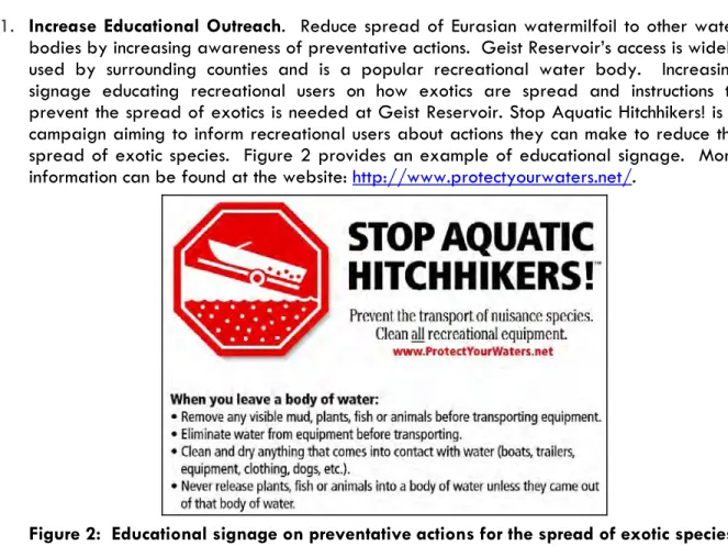
1. Increase Educational Outreach. Reduce spread of Eurasian watermilfoil to other water bodies by increasing awareness of preventative actions. Geist Reservoir’s access is widely used by surrounding counties and is a popular recreational water body. Increasing signage educating recreational users on how exotics are spread and instructions to prevent the spread of exotics is needed at Geist Reservoir. Stop Aquatic Hitchhikers! is a campaign aiming to inform recreational users about actions they can make to reduce the spread of exotic species. Figure 2 provides an example of educational signage. More information can be found at the website: http://www.protectyourwaters.net/.
Figure 2: Educational signage on preventative actions for the spread of exotic species.
2. Maintain and Enhance Diversity of the Native Aquatic Plant Community. Reduce the spread of Eurasian watermilfoil through educational outreach and selective management in high traffic areas should it become a significant impact to recreational use which would
increase the potential for native plants to establish. The type of substrate affects a lake’s ability to support aquatic vegetation. Lakes that have mucky, organic, nutrient-rich substrates have an increased potential for plant growth compared to lakes with gravelly, rocky substrates. The substrate of Geist Reservoir consists largely of sand although areas of muck and clay exist as well. While sandy substrates typically support healthy aquatic plant communities, this is only true when sufficient organic material is mixed in with the sand to provide a nutritional base for the rooted plants. (Giolitto and Olyphant, 2002). In addition to Eurasian watermilfoil reduction, watershed activities to improve the water clarity will benefit the native aquatic plant communities’ ability to establish.
Specific actions are proposed as follows to facilitate achievement of the overall LARE management goals for Geist Reservoir.
1. Promote and Maintain the Diversity of Native Aquatic Plant Species. A diverse native aquatic vegetative community is important in Geist Reservoir as they provide fish habitat, stabilize the shoreline, and prevent the establishment and/or spread of Eurasian watermilfoil and other invasive species. Due to these multiple benefits, one of the specific goals of this plan is to promote and maintain a healthy diversity of native aquatic plant species, while recognizing that some vegetation management may be necessary to provide reasonable public access for recreation. Geist Reservoir has a low native species diversity which is attributed to lack of shoreline, substrate composition and turbid water. Watershed activities to improve the water quality within Geist Reservoir may help promote the growth of native vegetative species. Due to the complexities of the watershed and its relationship to the reservoir with regards to algae and other invasive species, no treatment actions are proposed for management at this time.
Exotic Species Management Efforts at Geist Reservoir
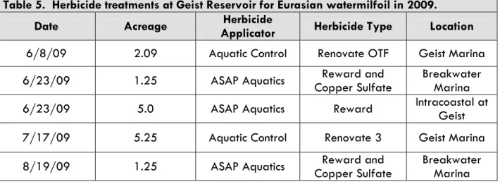
Herbicide treatments have primarily been privately funded and conducted within the coves and shoreline areas of Geist Reservoir over the past ten years. Treatments have been applied as a measure for lake front access. Geist Reservoir 2009 treatment records were obtained through the IDNR and herbicide application details are provided in table 5. The total acreage of treatment that occurred in Geist Reservoir in 2009 was 14.84 acres.
Table 5. Herbicide treatments at Geist Reservoir for Eurasian watermilfoil in 2009.
Date Acreage Applicator Herbicide Herbicide Type Location
6/8/09 2.09 Aquatic Control Renovate OTF Geist Marina
6/23/09 1.25 ASAP Aquatics Copper Sulfate Reward and Breakwater Marina
6/23/09 5.0 ASAP Aquatics Reward Intracoastal at Geist
7/17/09 5.25 Aquatic Control Renovate 3 Geist Marina
8/19/09 1.25 ASAP Aquatics Copper Sulfate Reward and Breakwater Marina Aquatic Control completed two treatments on Geist Reservoir in 2009 for control of Eurasian watermilfoil (Exhibit 4). The June treatment was a total of 2.09 acres and the July treatment was a total of 5.25 acres. Renovate OTF was used in June, and Renovate3 was used in July. Treatments were completed with a target triclopyr concentration of 1.5 ppm within treatment areas. Treatments effectively controlled targeted Eurasian watermilfoil within 14 days and little to no re-growth was recorded in late summer to early fall. Treatment area 2 received complaints in September due to the influx of native vegetation, primarily coontail (Ceratophyllum demersum). ASAP Aquatics treated 5 acres of Eurasian watermilfoil within the Intracoastal Marina on June 23, 2009 using 7 gallons of Reward (diquat) (Exhibit 5). In addition to the Intracoastal Marina treatment, ASAP Aquatics completed two treatments in the Breakwater Marina of Geist reservoir for a total of 1.25 acres. The June 23, 2009 Breakwater Marina treatment required 2 gallons of Reward diquat and 25 lbs of copper sulfate (Exhibit 6). The second Breakwater Marina treatment was conducted August 19, 2009 and required 1.5 gallons of Reward diquat and 15 lbs of copper sulfate.
Indiana Data Spatial Portal 2006 Orthophotography
Aquatic Control 2009 Eurasian watermilfoil Herbicide Treatment Locations
Geist Reservoir Aquatic Vegetation Management Plan 2009 - 2013 09006 4 1 1
±
TITLE: PROJECT:PROJECT NO.: EXHIBIT:
SHEET: OF: BASE LAYER: V3 Companies 7325 Janes Avenue Woodridge, IL 60517
[
_
LegendEurasian Watermilfoil Treatment 6/8/09 Eurasian Watermilfoil Treatment 7/17/09
Area 1: 1.5 Acres
Area 3: 0.59 Acres Area 2: 5.25 Acres
Upper White River Watershed Alliance 723 West Michigan Street Indiana Data Spatial Portal
2006 Orthophotography
ASAP Aquatics 2009 Eurasian watermilfoil Herbicide Treatment in Intracoastal Marina
Geist Reservoir Aquatic Vegetation Management Plan 2009 - 2013 09006 5 1 1
±
TITLE: PROJECT:PROJECT NO.: EXHIBIT:
SHEET: OF:
BASE LAYER: CLIENT:
QUADRANGLE: DATE: SCALE:
V3 Companies 7325 Janes Avenue Woodridge, IL 60517 630.724.9200 phone 630.724.9202 fax www.v3co.com
[
_
Legend Intracoastal TreatmentIndiana Data Spatial Portal 2006 Orthophotography
ASAP Aquatics 2009 Eurasian watermilfoil Herbicide Treatment within Breakwater Marina
Geist Reservoir Aquatic Vegetation Management Plan 2009 - 2013 6 1 1
±
TITLE: PROJECT:PROJECT NO.: EXHIBIT:
SHEET: OF: BASE LAYER: V3 Companies 7325 Janes Avenue Woodridge, IL 60517
[
_
LegendTier II Sampling Methods
Tier II aquatic sampling protocols were established by the IDNR to accurately describe and characterize the aquatic plant community of any particular water body, in a repeatable, consistent and analytical manner. Tier II sampling provides quantitative data on the occurrence, distribution, and abundance of aquatic plants within a water body. This sampling protocol is intended to:
1. Document the distribution and abundance of submersed and floating-leaved aquatic vegetation within selected areas and at a lake-wide scale, and
2. Compare present distribution and abundance of particular aquatic plants with past distribution and abundance within select areas and at a lake-wide scale.
LARE Tier II aquatic plant monitoring consists of a spring and summer sampling effort. Spring sampling is typically conducted between May 15 and June 15, and summer sampling typically occurs between July 15 and August 31. Tier II sampling efforts at Geist Reservoir in 2009 were within the designated sampling windows.
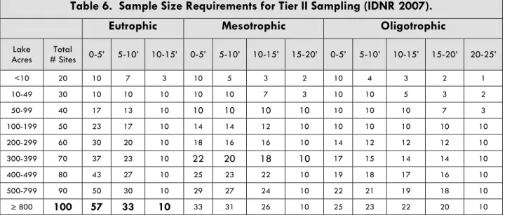
The number and depth of sampling locations are determined by lake size, trophic status and apportioned by depth class (Table 6). The following table was used to determine the number and depths of sampling locations (note: table excludes hypereutrophic status).
Table 6. Sample Size Requirements for Tier II Sampling (IDNR 2007).
Eutrophic Mesotrophic Oligotrophic
Lake
Acres # Sites Total 0-5’ 5-10’ 10-15’ 0-5’ 5-10’ 10-15’ 15-20’ 0-5’ 5-10’ 10-15’ 15-20’ 20-25’
<10 20 10 7 3 10 5 3 2 10 4 3 2 1 10-49 30 10 10 10 10 10 7 3 10 10 5 3 2 50-99 40 17 13 10 10 10 10 10 10 10 10 7 3 100-199 50 23 17 10 14 14 12 10 10 10 10 10 10 200-299 60 30 20 10 18 16 16 10 14 12 12 12 10 300-399 70 37 23 10 22 20 18 10 17 15 14 14 10 400-499 80 43 27 10 25 23 22 10 19 18 17 16 10 500-799 90 50 30 10 29 27 24 10 22 21 19 18 10 ≥ 800 100 57 33 10 33 31 26 10 25 23 22 20 10
Geist Reservoir has a surface area of 1,900 acres and is rated as eutrophic, therefore, 100 sampling locations were required at the depth distribution shown in bold in Table 6. Approximate sample site locations were randomly spaced on a bathymetric map based on the depth categories (Figure 3). The blue shaded areas with a corresponding number in Figure 3 represent areas that Sportsman Connection identified as a productive fishing location. Pre-designated sample site locations were navigated to based on visual markers. The depth category in the vicinity was found using a Humminbird 383c depth finder. The location of each sampling point was recorded using a WAAS-enable GPS unit (estimated accuracy ± 3m) (Exhibit 7).
Aquatic Veget a tion M anagement Plan (200 9-2013) V3 Compan ies Geist Reserv oir, Hamilton and Marion Co unt ies, Ind iana March – 2010 Figure 3: Ge
ist Reservoir Bathymetri
c
Map (Courtesy of Spor
! ( !( !( ! ( ! ( ! ( ! ( ! ( ! ( ! ( ! ( ! ( ! ( ! ( ! ( ! ( ! ( ! ( ! ( ! ( ! ( ! ( ! ( ! ( ! ( ! ( ! ( ! ( ! ( ! ( ! ( ! ( ! ( ! ( ! ( ! ( ! ( ! ( ! ( ! ( ! ( ! ( ! ( ! ( ! ( ! ( ! ( ! ( ! ( ! ( ! ( ! ( ! ( ! ( ! ( ! ( ! ( ! ( ! ( ! ( ! ( ! ( ! ( ! ( ! ( ! ( ! ( ! ( ! ( ! ( ! ( ! ( ! ( !( !( ! ( ! ( ! ( ! ( ! ( ! ( ! ( ! ( ! ( ! ( ! ( ! ( ! ( ! ( ! ( ! ( ! ( ! ( ! ( !( ! ( ! ( ! ( ! ( ! ( 9 8 7 6 5 4 2 1 99 98 97 96 95 94 93 92 91 90 89 88 87 86 85 84 83 82 81 8079 78 77 76 75 74 73 72 71 70 69 68 67 66 65 64 63 61 60 59 58 57 56 55 54 53 52 51 49 48 47 46 4544 43 41 40 39 38 37 36 35 34 33 32 31 30 29 28 27 26 25 24 23 22 21 20 12 15 19 18 17 16 14 13 11 10 100
Upper White River Watershed Alliance 723 West Michigan Street Indiana Data Spatial Portal
2006 Orthophotography
Geist Reservoir 2009 Tier II Sampling Locations Geist Reservoir Aquatic VegetationManagement Plan 2009 - 2013
09006 7
1 1
±
TITLE: PROJECT:
PROJECT NO.: EXHIBIT:
SHEET: OF:
BASE LAYER: CLIENT:
QUADRANGLE: DATE: SCALE:
V3 Companies 7325 Janes Avenue Woodridge, IL 60517 630.724.9200 phone 630.724.9202 fax www.v3co.com Legend !
Tier II Sampling Methodology
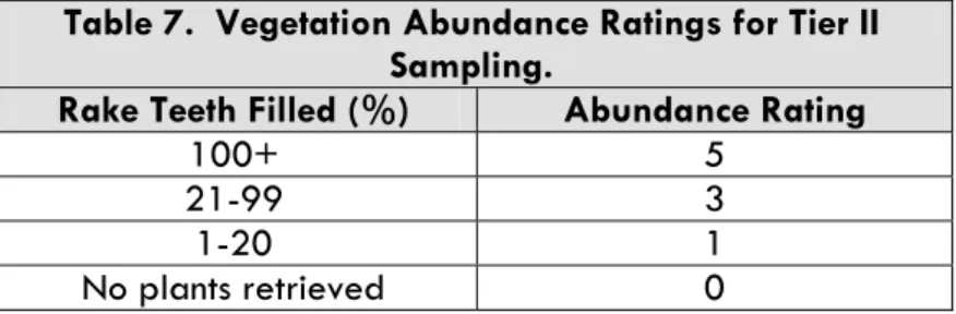
A double-headed thatch rake with attached nylon rope was used to sample the aquatic vegetation at each sampling location. The rake was lowered to the bottom of the reservoir, and an extra ten feet of slack was let out in the rope as the boat drifted. Then the rake was dragged along the reservoir bottom for a few feet and pulled up through the water column. All vegetation retrieved on the teeth of the rake was gathered into the boat and separated by species. Plants of each species were piled onto one side of the rake for a score of 1-5, based on the following table (Table 7). Visible “holes” in the rake teeth were filled without overly packing plants onto the rake. In addition to recording the density of each species, the overall density was recorded of all plants at a sampling location.
Table 7. Vegetation Abundance Ratings for Tier II Sampling.
Rake Teeth Filled (%) Abundance Rating
100+ 5 21-99 3 1-20 1
No plants retrieved 0
After the Tier II data was collected, it was imported into a Microsoft Excel spreadsheet to calculate plant community metrics used by IDNR (IDNR 2007). Site frequency measures how often a species was collected at the Tier II sampling locations. It is calculated by the following equation: Site Frequency = (# of sites where the species was collected) X 100
Total # of sample sites
Relative density is calculated as the sum of the rake scores for a species divided by the total number of sample sites in the survey. In contrast, mean density measures the abundance of a species in areas where it is growing. These values are calculated by the following equations: Mean Density = (Sum of all rake scores for a species)
(Total # of sites where the species was collected) Relative Density = (Sum of all rake scores for a species)
(Total # of sample locations)
The dominance index of each species is a metric that combines the frequency of occurrence and relative density to reflect the relative dominance of a species within the aquatic plant community. It is calculated as:
Dominance Index = (Sum of all rake scores for a species) X 100 (Total # of sample locations X 5)
Tier II 2009 Sampling Results
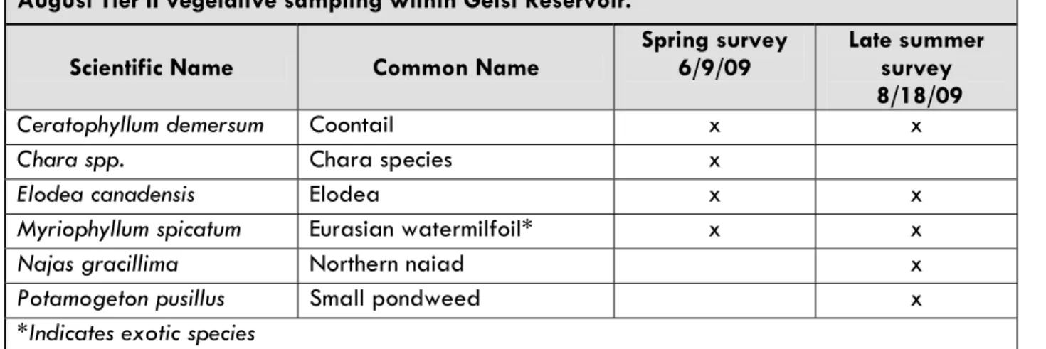
The Tier II Aquatic Vegetation Survey Protocol, designated by the IDNR, serves as a standardized method to document the occurrence, distribution, and abundance of aquatic vegetation. Spring and late summer Tier II vegetation surveys were conducted on Geist Reservoir in 2009. The information collected is useful to monitor changes in the vegetative community over time and identify success or failure of the exotic species control techniques implemented. A table outlining the scientific and common names of species collected or observed during the 2009 sampling surveys in Geist Reservoir is listed below (Table 8).
Table 8. Scientific and common names of species collected or observed for both June and August Tier II vegetative sampling within Geist Reservoir.
Scientific Name Common Name Spring survey 6/9/09 Late summer survey 8/18/09
Ceratophyllum demersum Coontail x x
Chara spp. Chara species x
Elodea canadensis Elodea x x
Myriophyllum spicatum Eurasian watermilfoil* x x
Najas gracillima Northern naiad x
Potamogeton pusillus Small pondweed x
Results of Spring Tier II Survey- June 9, 2009
A total of 4 species were identified up to a maximum depth of 6 feet. The secchi disk depth measurement was 4 feet during the June Tier II survey. Emergent species observed during the sampling effort include spatterdock (Nuphar advena), white water lily (Nymphaea oderata), and water willow (Justicia americana). Water willow is the most dominant emergent species throughout Geist Reservoir and is able to establish near seawalls. Geist Reservoir’s spring sampling results from depth ranges of 0 to 10 feet are provided below (Table 9a – 9c). The depth range of 10 to 15 feet was excluded as plants were not retrieved at these depths.
Table 9a: Geist Reservoir Spring Tier II survey results all depths (0 – 15 feet).
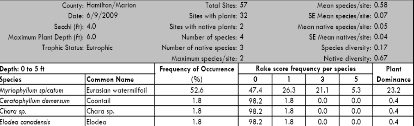
Hamilton/Marion 6/9/2009 4.0 6.0 Eutrophic Common Name Eurasian watermilfoil Coontail Chara sp. Elodea
The Tier II results for the depth range of 0 to 15 feet identified Eurasian watermilfoil at the highest percentage of sample sites (31%). Distribution and abundance of Eurasian watermilfoil is presented in Exhibit 8. Eurasian watermilfoil was present at depths ranging from 1 to 6 feet. Eurasian watermilfoil was collected with a rake score of 1 (1-19% rake teeth filled) at 16 sampling locations, a rake score of 3 (20-100% rake teeth filled) at 12 sampling locations, and a rake score of 5 (+100% rake teeth filled) at three locations. Eurasian watermilfoil was observed within the vicinity of 3 sampling locations. The maximum number of species collected at a sampling location was 2 and the average number of species collected was 0.35. Three native species were collected during the spring survey which included coontail, chara, and elodea (Exhibit 9).
The 0 to 5 foot depth zone represented all species collected during the spring survey effort. The 0 to 5 foot depth zone had vegetation at 32 of the 57 sampling locations. Native species were collected at 2 sampling locations. The maximum number of species collected at a sampling location was 2 with an average of 0.58 species per site. The most dominant species within this depth zone was Eurasian watermilfoil and occurred at 52.6% of sampling locations. Coontail, chara and elodea all had a frequency of occurrence of 1.8% and were collected with a rake score of 1.
Two species were collected within the 5 to 10 foot depth zone. Vegetation was present at 2 of the 33 sampling locations within this depth zone. The maximum number of species collected at a sampling location was 1 and the average number of species collected at a sampling location was 0.06. Eurasian watermilfoil and coontail had the same frequency of occurrence (3.0%) and were collected with a rake score of 1. Eurasian watermilfoil has a lower light requirement compared to native species but does not appear to be dominating the deeper zone of Geist Reservoir.
Water Willow (Justicia americana) is an emergent aquatic species that is not included in the Tier II Survey Protocol. Its presence throughout Geist Reservoir was noted during spring sampling due to the lack of vegetative structure present within Geist Reservoir (Figure 4). This species is common throughout Geist Reservoir and provides vegetative cover for many aquatic species and is an important native species to protect (Exhibit 10).
Figure 4: Stand of water willow being utilized as cover by waterfowl.
! ( !( !( ! ( ! ( ! ( ! ( ! ( ! ( ! ( ! ( ! (
!
(
! ( ! ( ! ( ! ( ! ( ! (!
(
! (!
(
! ( ! ( ! ( ! ( ! ( ! ( ! ( ! ( ! (!
(
! ( ! (!
(
! (!
(
!
(
! ( ! (!
(
! ( ! (!
(
! (!
(
!
(
! ( ! ( ! ( ! ( ! ( ! (!
(
! ( ! ( ! ( ! ( ! ( ! (!
(
! ( ! ( ! ( ! ( ! ( ! ( ! ( ! ( ! ( ! ( ! ( ! ( !( !( ! ( ! ( ! ( ! ( ! ( ! ( ! ( ! ( ! (!
(
! (!
(
! ( ! ( ! ( ! ( !( ! (!
(
!(!
(
! ( ! ( ! ( ! ( 9 8 7 6 5 4 3 2 1 99 98 97 96 95 94 93 92 91 90 89 88 87 85 84 83 82 81 8079 78 77 76 75 74 73 72 71 70 69 68 67 66 65 64 63 61 60 59 58 57 56 55 54 53 52 51 50 49 48 47 46 4544 43 41 40 39 38 37 36 35 34 33 32 31 30 29 28 27 26 25 24 23 22 21 20 12 15 19 18 17 16 14 13 11 10 100Upper White River Watershed Alliance 723 West Michigan Street Indiana Data Spatial Portal
2006 Orthophotography
Pre-treatment Eurasian watermilfoil Distribution and Abundance
Geist Reservoir Aquatic Vegetation Management Plan 2009 - 2013 09006 8 1 1
±
TITLE: PROJECT:PROJECT NO.: EXHIBIT:
SHEET: OF:
BASE LAYER: CLIENT:
QUADRANGLE: DATE: SCALE:
V3 Companies 7325 Janes Avenue Woodridge, IL 60517 630.724.9200 phone 630.724.9202 fax www.v3co.com Legend
Eurasian watermilfoil Abundance
!
( No Plants Retrieved !
( 1-19% Rake Teeth Filled
!
(
20-100% Rake Teeth Filled!
(
+100% Rake Teeth Filled!
!
(
!
(
!
(
#
*
!
y
9 8 7 6 5 4 3 2 1 31 30 10Indiana Data Spatial Portal 2006 Orthophotography
Pre-treatment Distribution and Abundance of Chara, Coontail, and Elodea
Geist Reservoir Aquatic Vegetation Management Plan 2009 - 2013
09006 9 1
±
TITLE: PROJECT:
PROJECT NO.: EXHIBIT:
SHEET: OF: BASE LAYER: V3 Companies 7325 Janes Avenue Woodridge, IL 60517 Legend
!
y
access#
*
Elodea!
(
Chara!
(
Coontail *All vegetation recorded with 1-19% Rake Teeth Filled! ( ! ( ! ( ! ( ! ( ! ( ! ( ! ( ! (
! ( !( ! ( ! ( ! ( ! ( ! ( ! ( ! ( ! ( ! ( ! ( ! ( ! ( ! ( ! ( ! ( ! ( ! ( ! ( ! ( ! ( ! ( ! ( ! ( ! ( ! ( ! ( ! ( ! ( ! ( ! ( ! ( ! ( ! ( ! ( ! ( ! ( ! ( ! ( ! ( ! ( ! ( ! ( ! ( ! ( ! ( ! ( ! ( ! ( ! ( ! ( ! ( ! ( ! ( ! ( ! ( ! ( ! ( ! ( ! ( ! ( ! (
!
(
!
(
! ( ! ( ! ( ! ( ! ( ! ( ! ( ! ( !( !( ! ( ! (!
(
! ( ! ( ! ( ! ( ! ( ! ( ! ( ! ( ! ( ! ( ! ( ! ( ! ( ! ( ! ( ! ( !( ! ( ! ( ! ( ! ( ! ( 9 8 7 6 5 4 3 2 1 99 98 97 96 95 94 93 92 91 90 89 88 87 86 85 84 83 82 81 8079 78 77 76 75 74 73 72 71 70 69 68 67 66 65 64 63 62 61 60 59 58 57 56 55 54 53 52 51 50 49 48 47 46 4544 43 42 41 40 39 38 37 36 35 34 32 31 30 29 28 27 26 25 24 23 22 21 20 12 15 19 18 17 16 14 13 11 10 100Upper White River Watershed Alliance 723 West Michigan Street Indiana Data Spatial Portal
2006 Orthophotography
Pre-treatment Water Willow Distribution and Abundance
Geist Reservoir Aquatic Vegetation Management Plan 2009 - 2013
09006 10 11
±
TITLE: PROJECT:
PROJECT NO.: EXHIBIT:
SHEET: OF:
BASE LAYER: CLIENT:
QUADRANGLE: DATE: SCALE:
V3 Companies 7325 Janes Avenue Woodridge, IL 60517 630.724.9200 phone 630.724.9202 fax Legend
Water Willow Abundance
!
( No Plants Retrieved
!
( 1-19% Rake Teeth Filled
!
(
20-100% Rake Teeth Filled!
Results of Late Summer Tier II Survey- August 19, 2009
A total of 5 species were identified up to a maximum depth of 8 feet among the 100 Tier II sampling locations during the August 19, 2009 survey. Geist Reservoir’s sampling results from depth ranges of 0 to 15 feet are provided below (Table 10a – 10c). The secchi disk depth measurement was taken after completion of vegetation sampling efforts and was recorded at 2 feet. The depth range of 10 to 15 feet was excluded as plants were not retrieved at these depths.
Table 10a: Geist Reservoir Late Summer Tier II survey results all depths (0 – 20 feet).
Table 10b: Geist Reservoir Late Summer Tier II survey results 0 to 5 foot depth zone.