M
ANAGEMENT
P
LAN
for E. C. Manning
Provincial Park and
Cascade Recreation Area
November, 2004
Ministry of Environment Environmental Stewardship Division
E. C. Manning Provincial Park and
Cascade Recreation Area
M
ANAGEMENT
P
LAN
Prepared by
Environmental Stewardship Division
Okanagan Region
Library and Archives Canada Cataloguing in Publication Data
British Columbia. Environmental Stewardship Division.
E.C. Manning Provincial Park and Cascade Recreation Area management plan.
Cover title: Management plan for E.C. Manning Provincial Park and Cascade Recreation Area.
“November 2004”
Available also on the Internet. ISBN 0-7726-5416-6
1. E.C. Manning Park (B.C.). 2. Cascade Recreation Area (B.C.). 3. Provincial parks and reserves - British Columbia - Management. 4. Recreation areas - British Columbia - Management. I. Title. II. Title: Management plan for E.C. Manning Provincial Park and Cascade Recreation Area.
FC3815.M35B74 2005 333.783’097115 C2005-960182-5
Vision Statement
E. C. Manning Park has significant conservation and recreation values that will continue to draw large numbers of tourists and residents, particularly from the southwestern part of the province. The park will be managed to protect its natural values and provide a range of all-season intensive and backcountry recreation
opportunities on a long-term sustainable basis. Management emphasis will increasingly be on protecting conservation values. Much of the park’s recreation potential has been realized. Demand will continue to grow placing increasing pressure to expand facilities or to introduce new opportunities. Future expansion will be evaluated in terms of its environmental impact, sustainability and cost/benefit to the park and limited to that which has little impact on existing use and poses no serious threat to the conservation values. Visitor capacity limits, innovative
management techniques and appropriately developed facilities will be needed to ensure use does not exceed physical carrying capacity, particularly in the backcountry.
The Cascade Recreation Area continues to be managed as a remote wilderness area with limited facilities requiring the user to be self-reliant as much as possible. Its significant conservation and recreation values have resulted in its reclassification to Class A park status.
Table of Contents
Executive Summary ... iv
Introduction... 1
THE MANAGEMENT PLANNING PROCESS...1
BACKGROUND SUMMARY...1
RELATIONSHIP WITH OTHER LAND USE PLANNING...1
Management Issues ... 4
MANAGEMENT OF PROTECTED AREA VALUES...4
LEVEL OF DEVELOPMENT...4
ACCESS MANAGEMENT...4
PROVISION OF BACKCOUNTRY RECREATIONAL FACILITIES...5
GIBSON PASS RESORTS INC. ...5
FIRST NATIONS INTERESTS...5
GRIZZLY BEAR RECOVERY...5
TENURES...6
Role of the Park and Recreation Area ... 7
PROVINCIAL AND REGIONAL CONTEXT...7
SIGNIFICANCE IN THE PROTECTED AREAS SYSTEM...7
PROTECTED AREA ROLES...8
Conservation...8
Tourism and Outdoor Recreation ...8
Cultural Heritage ...9
VISION STATEMENT...9
RELATIONSHIP WITH FIRST NATIONS...10
Protected Area Zoning ... 11
INTRODUCTION...11
INTENSIVE RECREATION ZONE...11
NATURAL ENVIRONMENT ZONE...11
SPECIAL FEATURE ZONE...12
WILDERNESS RECREATION ZONE...12
WILDERNESS CONSERVATION ZONE...12
Natural and Cultural Heritage Values Management ... 17
INTRODUCTION...17
GEOLOGY,SOILS AND LANDFORMS...17
WATER...18
VEGETATION...18
WILDLIFE...20
CULTURAL HERITAGE...21
LANDSCAPE SETTING AND FEATURE VALUES...22
LAND USES,TENURES AND INTERESTS...23
Access Management ...23
Existing Tenures, Alienations and Encumbrances Management...24
Gibson Pass Resorts Inc. ...25
Outdoor Recreation Opportunities Management... 27
INTRODUCTION...27
OUTDOOR RECREATION OPPORTUNITIES AND FACILITIES...27
Vehicle-Accessible Day Use Activities...28
Camping ...28
Boating ...29
Hiking, Mountain Biking, Horseback Riding ...30
Fishing and Hunting ...31
COMMERCIAL RECREATION OPPORTUNITIES...33
MANAGEMENT SERVICES...33
Communications ... 34
INTRODUCTION...34
MARKETING AND PROMOTION...34
AWARENESS AND PRE-TRIP PLANNING...35
ORIENTATION INFORMATION...35
NATURAL AND CULTURAL HERITAGE EDUCATION...35
Plan Implementation ... 37
Appendix I – Conservation Data Centre List of Red and Blue-listed Species ... 38
Appendix II – BC Parks Management Planning Zoning Framework ... 40
Appendix III - Protected Areas Strategy (PAS) Goals and Guiding Principles and BC Parks’ Conservation and Recreation Goals ... 42
List of Figures Figure 1 – E. C. Manning Park and Cascade Recreation Area Regional Context………. 2
Figure 2 – E. C. Manning Park and Cascade Recreation Area Features……… 3
Figure 3 – E. C. Manning Park and Cascade Recreation Area Zoning……….………….. 12
Figure 4 – Acceptable Activities/Uses/Facilities in E. C. Manning Park and Cascade Recreation Area………… 13
Executive Summary
This management plan provides strategic direction for the long-term management of E. C. Manning Provincial Park and Cascade Recreation Area.
These two protected areas contribute an impressive variety of provincially significant conservation, recreation and cultural heritage values to the protected areas system. E. C. Manning Provincial Park and Cascade Recreation Area contain the following attributes:
• A broad range of year-round front and backcountry outdoor recreation opportunities.
• A large representative example of the Hozameen Range Ecosection.
• Representation of 5 of the 14 biogeoclimatic zones in the province and 9 subzones and variants due to the park’s location in the transition zone between the temperate, wet coastal environment and the harsher, drier interior.
• A large number of red- and blue-listed species and 2 record trees.
• Provincially significant historic trails including the Dewdney Trail.
The vision is for these very popular areas to continue to accommodate increasing numbers of visitors. This will require careful management of the resources with an emphasis on protecting the natural and cultural heritage values. New recreational facilities or uses will only be considered after a rigorous examination to ensure that no serious threat to the protected area values results.
The highway corridor, Lightning Lakes/Gibson Pass area and Blackwall Road are zoned Intensive Recreation where management actions will meet user demand while protecting natural values. Outstanding natural features within the highway corridor are zoned Special Feature. Natural Environment Zone covers the Flash Lake-Castle Creek area, the Cambie Creek area and the Granite Mountain area, the latter to allow snowmobiling. Most of the backcountry is zoned either Wilderness Recreation or Wilderness
Conservation.
The plan recommends:
• Pursuing the reclassification of Cascade Recreation Area to Class A Park status. If reclassification occurs, existing uses, other than cattle grazing and mining, will be permitted to continue.
• Reviewing and updating Gibson Pass Resorts Inc. park use permit # OK9710046 for Manning Park Resort (lodge and ski area)
• Supporting a First Nation traditional use inventory
• Working with other interests to protect sensitive viewing areas and restore roadside disturbances
• Completion of an ecosystem plan with sub-components for vegetation management, fish and wildlife management (including species at risk), fire management and disease and insect management
• In consultation with, and with the assistance of, affected interests, removal of mountain pine beetle infested trees in high priority areas to reduce the hazard to the public, removal of trees to establish large fuel breaks in critical areas and the use of prescribed fire to restore the ecosystem and reduce the potential for catastrophic wildfire.
• Working with the North Cascades Grizzly Bear Recovery Team and stakeholders to implement the approved Recovery Plan for Grizzly Bears in the North Cascades in a manner consistent with the management goals and objectives for the Park and Recreation Area
• Working with the Spotted Owl recovery team to assist in the protection and recovery of this specie within the Park and Recreation Area.
• Preparing a recreation plan with a trail plan sub-component
• Establishing wilderness campsites and vehicle camps for horse users
• Continuation of motorized use on the Tulameen-Whipsaw Road through the northeast corner of the recreation area
• Prohibiting off-road motorized recreation activities (e.g. heli-hiking, heli-skiing, snow-cat assisted activities, powered water-craft, 4x4s, motorcycles, quads or other ATVs) except snowmobiles (only in the Granite Mountain area)
Introduction
The Management Planning Process
A management plan is a strategic document that identifies the protected area’s
conservation, recreation and cultural heritage roles, its long-term vision, zoning, and sets out objectives, strategies and priorities for management actions. The process for
preparing a management plan involves a rigorous analysis of protected area information in consultation with various interests and the general public.
Background Summary
E. C. Manning Park, established in 1941 with adjacent protected areas added in subsequent years, consists of 70,844 hectares of rugged, forest-clad mountains, deep valleys, alpine meadows, lakes and fast-moving rivers. The park contains a large number of scenic, historic, floral and faunal attractions and provides a wide range of both summer and winter recreational opportunities.
Bisected by Highway 3, the park is one of the most popular destination areas in the province. Its popularity stems from its inherent landscape diversity, its four season recreation opportunities, easy access and location within a 3 hour drive of nearly 70% of British Columbia’s population.
Cascade Recreation Area, containing 11,858 hectares, is adjacent to the northwest portion of E. C. Manning Park. The recreation area is roadless except for the
Whipsaw-Tulameen Road which passes through its northeast corner. The recreation area was established in 1987 after considerable public discussion, first through the Cascade Wilderness Study and finally by the Wilderness Advisory Committee. As a result of the recommendation from the Protected Areas Strategy Table for the Lower Mainland Region, the Snass River drainage portion of the recreation area was upgraded to Class A park status and added to E. C. Manning Park in 1999. Along with such features as
Paradise Meadows and the Punch Bowl, the recreation area contains a network of historic trails found in a wilderness setting.
Relationship with Other Land Use Planning
The management plan has taken into consideration management direction for the Skagit Valley Park as well as input from managers of contiguous areas in the United States and British Columbia. The management plan also reflects discussions with many groups and individuals that have been consulted over the years.
Management Issues
The following issues require management action.
Management of Protected Area Values
The protected areas contain an abundance of provincially significant conservation and cultural features that are the backbone of thier recreation opportunities. The high level of front country and backcountry use occurring in the park could threaten these values. Protection of conservation and cultural values must be a management priority if quality recreation opportunities are to continue to be provided.
Mountain Pine Beetle
In recent times, mountain pine beetles, a natural part of all pine forests in the province, have spread extensively throughout much of the Similkameen Valley within the park. This has created a serious increase in the fuel load which, combined with the absence of major fires in recent history, has increased the risk of a high intensity wildfire in the park. Management direction is needed to guide ecosystem restoration and reduce the wildfire hazard to park values, facilities and users as well as nearby residents.
Level of Development
E. C. Manning Park has had a long history of facility development. This is most evident in the highway corridor and the Pinewood Flats/Gibson Pass area. The park and
recreation area also have an extensive trail system providing access to most backcountry areas. There is a limit to the amount of development the protected areas can
accommodate without affecting conservation and recreation values. There is a need to provide guidelines on how to deal with increased use as well as future demand for more facilities or the provision of new recreation opportunities.
Access Management
Management of road and trail access is the key to the provision of recreation
opportunities and the protection of natural and cultural heritage values. Opinions often differ widely within and between user groups. In the case of backcountry vehicle access, some want retention of roads or expanded vehicle access to and in the recreation area, while others want partial or total road closure to create a buffer to ensure a recreation experience free of motorized activity. Among trail users, there is a great deal of interest in more access particularly for horse riding, mountain biking, snowmobiling, ski touring
and groomed nordic skiing. Provision of access for one group could have an impact on other users. The management plan will provide overall direction regarding access management that recognizes the need for continued access to the protected areas and adjacent lands in a manner that does not threaten the primary objective of protecting the natural values.
Provision of Backcountry Recreational Facilities
There is a lack of backcountry facilities such as designated campsites in the protected areas and formal camping areas for horse users at the trailheads. Such facilities are needed to meet user needs and protect natural values.
Gibson Pass Resorts Inc
.
Gibson Pass Resorts Inc. is a private company holding a fifty year park use permit, with a 50 year renewal option, issued in 1984 for the use of parklands in the ski hill area, the Manning Park Lodge area and their employee-community base. Future plans for facility development and upgrading of recreational opportunities by the resort must be
synchronized with park conservation and recreational goals.
First Nations Interests
The Constitution Act,1982 and recent court decisions recognize and affirm aboriginal rights. Little is known of First Nation interests in the protected areas or how park management might affect those values.
Grizzly Bear Recovery
The North Cascade grizzly bear population was selected as a pilot project for recovery planning work under the Provincial Grizzly Bear Conservation Strategy. The large areas of high suitability habitat in the park and recreation area are expected to contribute towards the recovery effort for this population. The southern boundary of E. C. Manning Park adjoins the North Cascades National Park in the United States. Skagit Valley Provincial Park is adjacent to the western boundary of E. C. Manning. Together these protected areas form a large block of habitat which may help to sustain the North Cascades grizzly bear population, which is present on both sides of the US-Canadian border.
Tenures
The protected areas contain mineral claims, road, highway facility, grazing, guide
outfitting, and trapping tenures. Tenured activities have the potential to create impacts on the natural and cultural values and require close cooperative working relationships
between the tenure holders, park management and other agencies that have legislative authority for these tenures.
Role of the Park and Recreation Area
Provincial and Regional Context
E. C. Manning Provincial Park and Cascade Recreation Area are part of a system of more than 800 protected areas in the province. Other parks in the region include Skagit Valley Provincial Park, North Cascades National Park and Pasayten Wilderness in Washington state and a number of smaller protected areas.
The park’s and recreation area’s range of wet coastal to dry interior forests contribute to the conservation of plant and animal populations and biodiversity in the region.
The park and recreation area are located mid-way between the Lower Mainland and the Okanagan and within 3 hours of 70% of the provincial population. The presence of a wide range of year-round recreation opportunities and the privately-owned Manning Park Resort make the protected areas important regional and provincial tourism destinations.
Significance in the Protected Areas System
• E. C. Manning is one of the few major tourist destination parks offering a full range of year-round outdoor recreation opportunities and is one of the most popular parks in the protected areas system
• The park and recreation area protect more than half of the Hozameen Range Ecosection; the only large block of protected area in the ecosection
• The protected areas contain 5 of the 14 biogeoclimatic zones in the province and 9 subzones/variants1
1
The Biogeoclimatic Ecosystem Classification (BEC) system divides the province into 14 different biogeoclimatic zones. Zones are identified through a unique combination of soil types, plant species, moisture and climate. The subzone is the basic unit within the BEC system. Subzones are then grouped into zones to represent similar types of climatic factors over large geographical areas, or they can be divided into variants based on geographical changes in plant communities. Further detail on the BEC system is available from the Ministry of Forests website at http://www.for.gov.bc.ca/hre/becweb/
Biogeo-climatic Zone, Subzone, Variant Hectares within Province Hectares within all existing protected Areas % within all existing protected areas Hectares protected within Manning-Cascade % of protected area representation within Manning-Cascade % of provincial occurrence within Manning-Cascade Atunp 18232031 3795757 20.8% 12491 0.3% 0.1% CWHms1 499538 58613 11.7% 8628 14.7% 1.7% ESSFdc2 237976 16218 6.8% 7274 44.9% 3.1% ESSFdcp2 6270 685 10.9% 685 100.0% 10.9% ESSFmw 387265 143675 37.1% 45062 31.4% 11.6% ESSFmwp 5193 694 13.4% 694 100.0% 13.4% IDFdk2 352859 9795 2.8% 2615 26.7% 0.7% IDFww 133083 39905 30.0% 678 1.7% 0.5% MSdm2 353737 12736 3.6% 5592 43.9% 1.6%
• Protects approximately 31.4% of the protected areas system representation of ESSFmw, and over 10% of the ESSFdcp2 and ESSFmwp subzones, which are relatively rare in the province. E. C Manning contains the only representation of these latter two biogeoclimatic units in the protected areas system; contributes almost half of ESSFdc2 and MSdm2, two poorly represented biogeoclimatic units in the protected areas system
• Hosts a large number of rare plant and wildlife species significant in the province (6 red-listed species, 22 blue-listed species and 2 record trees as shown in Appendix I)
• With Skagit Valley Provincial Park, the US North Cascades National Park, and Pasayten Wilderness, forms the largest block of protected area at the northern terminus of the Cascade Mountains and protects important habitat for a range of wildlife including grizzly bear
• The longest protected section of the historic Dewdney Trail, a major coast-interior route of commerce until the early 1900s
Protected Area Roles
Conservation
The primary roles of E. C. Manning Provincial Park and Cascade Recreation Area are to protect:
• the range of elements and ecosystem functions representative of a large portion of the Hozameen Range Ecosection and smaller examples of the Eastern Pacific Ranges and Okanagan Range ecosections
• the many rare and endangered plant and animal species/communities and
• the spectacular natural features such as the sub-alpine meadows of the Blackwall Peak/Three Brothers area, Snass Mountain and the alpine larch on Mount Frosty The protected areas contribute significantly to the ecological integrity and viability of the region and management of these areas will support the implementation of the Recovery Plan for Grizzly Bears in the North Cascades. This may include use of habitat in the park and recreation area to support the translocation of grizzlies from other locations, if such action is approved pursuant to the Recovery Plan. The areas will also be managed to support the implementation of the approved recovery plan for spotted owl.
Tourism and Outdoor Recreation
The park is one of the most important providers of outdoor recreation in the region and contributes significantly to tourism in the area. The recreation role of the park is:
• in the Highway 3 corridor and Lightning Lakes area, to provide a range of vehicle-accessible attractions and services (public and commercial) including overnight and
day use opportunities (swimming, non-motorized boating, nature study and a broad range of trail-related summer and winter outdoor recreation activities) and
• in the backcountry, to provide low-impact opportunities in sub-alpine and forested settings for nature study, camping, hiking, horseback riding, mountain biking, cross-country skiing, ski touring and snowmobiling.
The recreation area’s recreation role is focused on providing remote recreation opportunities for horseback riding, hiking, ski-touring and camping.
Cultural Heritage
The cultural heritage role of the protected areas is to protect and interpret First Nations’ traditional use and resources, such as the culturally modified trees in the park and the history associated with the Dewdney, Hope Pass and Whatcom trails.
Vision Statement
E. C. Manning Park has significant conservation and recreation values that will continue to draw large numbers of tourists and residents, particularly from the southwestern part of the province. The park will be managed to protect its natural values and provide a range of all-season intensive and backcountry recreation
opportunities on a long-term sustainable basis. Management emphasis will increasingly be on protecting conservation values. Much of the park’s recreation potential has been realized. Demand will continue to grow placing increasing pressure to expand facilities or to introduce new opportunities. Future expansion will be evaluated in terms of its environmental impact, sustainability and cost/benefit to the park and limited to that which has little impact on existing use and poses no serious threat to the conservation values. Visitor capacity limits, innovative
management techniques and appropriately developed facilities will be needed to ensure use does not exceed physical carrying capacity, particularly in the backcountry.
The Cascade Recreation Area continues to be managed as a remote wilderness area with limited facilities requiring the user to be self-reliant as much as possible. Its significant conservation and recreation values have resulted in its reclassification to Class A park status.
Relationship with First Nations
The Upper Similkameen Band and the Sto:lo First Nation both include a part of or all of E. C. Manning Provincial Park and Cascade Recreation Area as part of their traditional territory. Other First Nations may also have an interest in the protected areas.
BC Parks has limited information on the values of the park and recreation area resources and features as they relate to First Nations’ culture and heritage. Increased knowledge of traditional uses and further consultation with First Nations people are required.
Once formal agreements or treaties have been reached with the First Nations, this management plan will be reviewed to determine whether it is in compliance with them. If it is not in compliance, then this management plan will be revised accordingly. Changes will be done through an open public review process so everyone understands what these changes mean to the park and recreation area, and their use and management.
Protected Area Zoning
Introduction
BC Parks uses zoning to assist in the planning and management of a provincial park. In general terms, zoning divides a park into logical units to apply uniform and consistent management objectives based on natural, cultural and recreational values. It also takes into account existing and projected patterns of access and recreation use in relation to specific conservation goals. The zones reflect the intended land use, the degree of human use, and the level of management and development. At one end of the spectrum, the Intensive Recreation Zone permits high levels of recreation and facility development. At the opposite end, the Wilderness Conservation Zone provides the highest level of
protection for natural and cultural values with minimal human presence. Between these, there are three additional zones: Natural Environment, Special Feature and Wilderness Recreation, providing a range of conservation and recreation priorities. These zones are summarized in Appendix II.
As indicated by Figure 3, all 5 zones are present in the zoning plan for E. C. Manning Park and the Cascade Recreation Area.
Intensive Recreation Zone
The Intensive Recreation Zone objective is to provide for a variety of readily accessible facility-oriented outdoor recreation opportunities. This zone may be intensely developed for user convenience. Facilities may include campgrounds, picnic areas, parking areas and other day use facilities. This zone also includes the Gibson Pass Resorts Inc. ski hill, lodge and community related facilities. The management intent of this zone is to
accommodate vehicle-based users in as natural a setting as possible.
In E. C. Manning Park, the highway corridor and the Gibson Pass/Lightning Lakes area are zoned as Intensive Recreation. The primary management concern will be to meet user demand while protecting natural values and maintaining a quality outdoor recreation experience. The Intensive Recreation Zone covers 9.6 per cent of E. C. Manning Park.
Natural Environment Zone
The objective of this zone is to protect scenic values and to provide for backcountry recreation opportunities in a largely undisturbed natural environment. This zone will have relatively low use but is moderately developed for user convenience. Facilities may include walk-in campsites and trails for hiking, horseback riding, mountain biking and cross-country skiing.
Three Natural Environment zones have been delineated: the Flash Lake–Castle Creek and Cambie Creek areas in the park and the Granite Mountain area in therecreationarea,
the latter being the only place in the park and recreation area where snowmobiling will be permitted. 13.9 per cent of E. C. Manning Park and 13 per cent of the Cascade
Recreation Area fall into the Natural Environment Zone.
Special Feature Zone
The objective of the Special Feature Zone is to protect and present significant natural or cultural resources, features or processes because of their special character, fragility and heritage values. Management is oriented toward maintaining a high-quality recreational and interpretive experience with limited, low impact facility development.
Special Feature zones, covering 0.4 per cent of the park, encompass a number of park features including Strawberry Flats, Sumallo Grove, Frosty Mountain larch,
Rhododendron Flats and Dry Ridge.
Wilderness Recreation Zone
The objective of the Wilderness Recreation Zone is to protect a remote, undisturbed natural landscape and to provide unassisted backcountry recreation opportunities
dependent on a pristine environment where no motorized activities will be allowed. Very low use is intended to provide solitary experiences and a wilderness atmosphere. Use may be controlled to protect the environment. Facilities are kept to a minimum and may include trails and primitive campsites.
The greater part of both the Cascade Recreation Area and E. C. Manning Park are zoned Wilderness Recreation, amounting to 73 for the park and 80 per cent for the recreation area. Most of the park north of Highway 3 and large blocks to the south as well as most of the recreation area are zoned Wilderness Recreation.
Wilderness Conservation Zone
The Wilderness Conservation Zone objective is to protect a remote, undisturbed natural landscape and to provide backcountry recreation opportunities dependent on a pristine environment. Very low use levels are intended to provide solitary experiences and a wilderness atmosphere and only non-mechanized means of access is permitted. No facilities are permitted.
The area south of Snass Mountain between Snass Creek and Skaist River, totaling 3.1 per cent of the park, is zoned Wilderness Conservation to protect an undisturbed natural landscape with pristine scenic values which has low use.
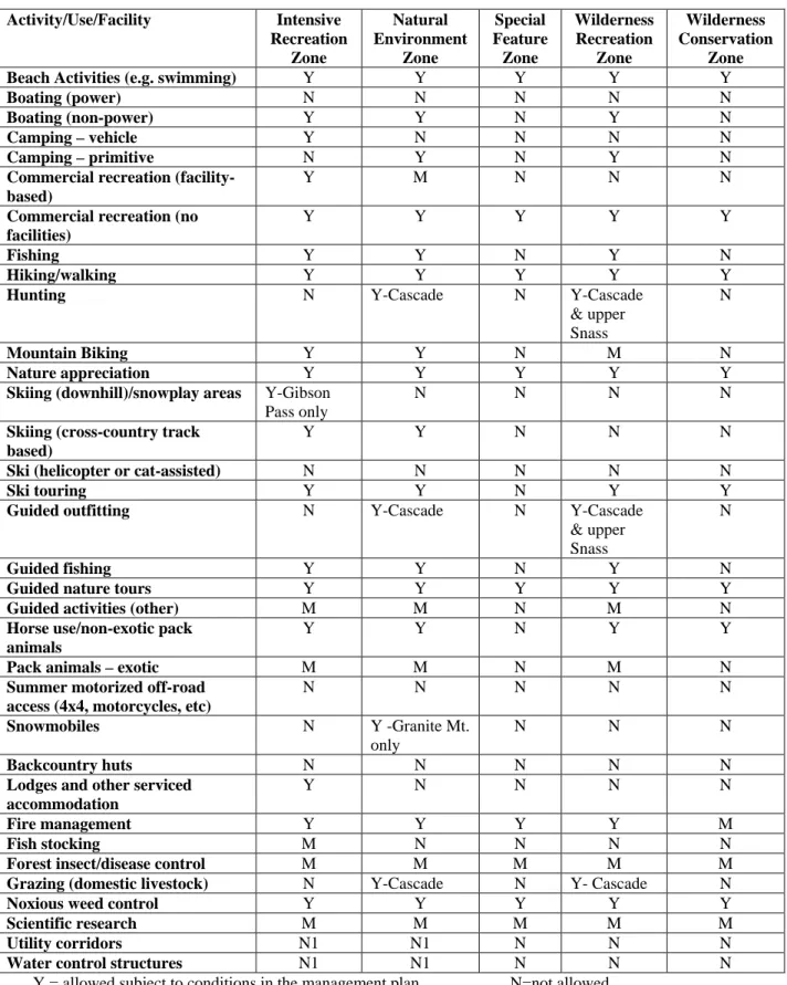
Figure 4 – Acceptable Activities/Uses/Facilities in E. C.
Manning Provincial Park and Cascade Recreation Area
Activity/Use/Facility Intensive Recreation Zone Natural Environment Zone Special Feature Zone Wilderness Recreation Zone Wilderness Conservation Zone
Beach Activities (e.g. swimming) Y Y Y Y Y
Boating (power) N N N N N
Boating (non-power) Y Y N Y N
Camping – vehicle Y N N N N
Camping – primitive N Y N Y N
Commercial recreation (facility-based)
Y M N N N
Commercial recreation (no facilities)
Y Y Y Y Y
Fishing Y Y N Y N
Hiking/walking Y Y Y Y Y
Hunting N Y-Cascade N Y-Cascade
& upper Snass
N
Mountain Biking Y Y N M N
Nature appreciation Y Y Y Y Y
Skiing (downhill)/snowplay areas Y-Gibson Pass only
N N N N
Skiing (cross-country track based)
Y Y N N N
Ski (helicopter or cat-assisted) N N N N N
Ski touring Y Y N Y Y
Guided outfitting N Y-Cascade N Y-Cascade & upper
Snass
N
Guided fishing Y Y N Y N
Guided nature tours Y Y Y Y Y
Guided activities (other) M M N M N
Horse use/non-exotic pack animals
Y Y N Y Y
Pack animals – exotic M M N M N
Summer motorized off-road access (4x4, motorcycles, etc)
N N N N N
Snowmobiles N Y -Granite Mt. only
N N N
Backcountry huts N N N N N
Lodges and other serviced accommodation
Y N N N N
Fire management Y Y Y Y M
Fish stocking M N N N N
Forest insect/disease control M M M M M
Grazing (domestic livestock) N Y-Cascade N Y- Cascade N
Noxious weed control Y Y Y Y Y
Scientific research M M M M M
Utility corridors N1 N1 N N N
Water control structures N1 N1 N N N
N1= allowed for expressed management purposes only M= may be permitted if compatible with protected area objectives; authorization required; may be subject to limitations note: Should Cascade Recreation Area be re-classified as a Class A Park, existing uses, except cattle grazing and mining, will continue to be permitted.
Natural and Cultural Heritage Values
Management
Introduction
The park and recreation area conserve important elements of British Columbia’s natural and cultural heritage. The primary goal of park management is to ensure the long term protection and enhancement of the park and recreation area’s natural and cultural values.
Geology, Soils and Landforms
As part of the Cascade Mountains, E. C. Manning Provincial Park and Cascade
Recreation Area are composed of two main bedrock groups. On the west side are folded, faulted sedimentaries and volcanic rocks of Mesozoic/Paleozoic origin; on the east are igneous intrusives of the late Mesozoic origin. The western section is more rugged and sharp, while the eastern part is more rounded.
The geologic history of the protected areas is one of deposition, uplift and erosion. The present landforms are the result of marine sedimentation and volcanic activities on the Cordilleran Geosyncline during Paleozoic and Mesozoic times.
A period of mountain buiding, including granitic intrusion, during the Jurassic and Cretaceous periods was followed by periods of stream erosion and uplift. Later glacial modification resulted in the present mountains and valleys. The glaciers deposited the mantle of colluvium.
Fossil beds laid down during the Mesozoic period are significant features of the park. The beds were the result of deposition during periods when oceans covered much of the area.
Humo-ferric Podzols and Dystric Brunisols soils are present with the podzols making up the majority of the protected areas.
Objectives Strategies
• To protect the geologic values • Manage recreational activities to avoid impacts on fossil beds
Water
E. C. Manning Park and the Cascade Recreation Area play an important role in protecting the headwaters of the Similkameen, Skagit and Tulameen river systems. Also present are the Lightning Lakes chain, Poland, Nicomen, Snowshoe, Punchbowl, and Grant lakes and many other small lakes, ponds and riparian areas that help to sustain the wildlife in the area.
The main stems of the Similkameen, Sumallo and Skagit rivers are paralleled by Highway 3 and much of the park development occurs within this corridor.
Objectives Strategies
• To protect and maintain the natural qualities of aquatic resources and their ecological processes within the
protected areas
• Maintain a high standard of water quality within the protected areas by working with the Ministry of Transportation, Ministry of Forests, forest companies, Gibson Pass Resorts Inc. and the regional districts
• Ensure proper location and maintenance of park facilities to minimize erosion
• Ensure high standards of design and maintenance of sanitation facilities
• Encourage proper disposal of human waste in the backcountry
• Minimize degradation of riparian habitat from cattle grazing in the recreation area
Vegetation
The protected areas contain an unusual range of vegetation because of their location in the transition zone between the temperate and wet coastal environment and the harsher, drier interior regime and their large range of elevational gradient.
The park and recreation area have extensive forests with lush coastal growth on the west side giving way to dry-land stands of pine and an occasional stand of larch such as found at Mt. Frosty. One of the more prominent features is the sub-alpine meadows in the Blackwall Peak/Three Brothers Mountain area. Other interesting plant communities include the Rhododendron Flats, Strawberry Flats and the Rein Orchids. A large number of rare and endangered species occur (see Appendix I).
Populations of mountain pine beetle (MPB), a natural part of any lodgepole pine forest, have been expanding recently in the Similkameen Valley portion of the park. As
elsewhere in the province, the proliferation of MPB populations is creating a build-up of fuel and an environment suitable for naturally occurring wildfire. This is occurring in the
more developed parts of the park which contain much of the vehicle access camping and day use facilities, Gibson Pass Resorts Inc. resort area and staff community, as well as the private development at East Gate adjacent to the park.
From 1981-1999, efforts were made to control the spread of the beetle in the park. The recent expansion of MPB numbers limits the options available for successful beetle control and ecosystem restoration in the park.
Objectives Strategies
• To maintain or restore natural plant communities and processes
• Complete and implement an ecosystem plan that includes sub-components covering fish and wildlife, vegetation, and insect, disease and fire
management that addresses:
⇒ the role of fire including the use of prescribed fire for ecosystem
restoration and to reduce fuel loading,
⇒ the strategy for dealing with insect and disease infestation (e.g. mountain pine beetle),
⇒ impact of recreational development and use in sensitive areas and
⇒ the management of vegetation for wildlife
• Retain trees and snags for bird and animal species
• Assess the impact of cattle grazing in the recreation area
• Initiate prescribed fire for ecological restoration purposes throughout the park that results in a vegetation mosaic of different ages and types appropriate to the forest and grassland ecosystems
• To reduce the hazard to the park users and surrounding communities from potential high intensity wildfires and hazard trees
• To remove beetle infested trees and manage the fuel hazard in high priority areas such as campgrounds and in the resort area
• In consultation with, and with the assistance of, the East Gate community, Ministry of Forests, Gibson Pass Resort, Ministry of Transportation, BC Hydro and the Upper Similkameen Indian Band, establish large fuel breaks in critical areas inside and outside of the park
Objectives Strategies
• To protect and support recovery of rare, endangered and vulnerable native plant communities and species
• Identify and protect sensitive vegetation from adverse impacts of recreational and other land uses
• Implement restoration activities as identified through recovery planning
• To prevent the establishment of non-native species
• Assess, monitor and control noxious and other invasive weed species through biological, mechanical or chemical means
• To improve knowledge of the vegetation
• Encourage scientific research
Wildlife
The varied topography, different climates and diverse plant communities combine to create a wide variety of habitats, which support one of the more diverse collections of wildlife in the province. The park and recreation area are home to large mammals such as black bear, grizzly bear (blue-listed), deer, elk and moose, as well as smaller mammals including marmot, mink, muskrat and beaver. Many bird species inhabit the park in all seasons. The western portion of the park has spotted owl (red-listed) habitat. Bull trout (blue-listed) are found in the Sumallo River and rainbow trout are present in the
Similkameen, Skagit, Sumallo and Tulameen rivers and many of the lakes, including the Lightning Lakes chain, and Nicomen and Poland lakes.
For many species, the protected areas contain only part of their required habitat. An integrated approach to their management is essential. The protected areas will play an important role in the preservation of key habitats, for example, in the recovery of the North Cascade grizzly bear population. The protection of wildlife from human activities should be an important management consideration, recognizing the significant recreation role the protected areas play in British Columbia.
Objectives Strategies
• To conserve viable populations of the fish and wildlife species associated with the protected areas
• Integrate management of fish and wildlife in the protected areas with regional fish and wildlife management strategies
• Conduct on-going fish and wildlife population and habitat inventories
• Monitor impact of recreation use on fish and wildlife populations and habitat; take
management action if necessary
• To protect and support recovery of rare, endangered and vulnerable species
• Monitor the condition of critical habitats; implement habitat protection and restoration measures as required
Objectives Strategies
• Support implementation of the Recovery Plan for Grizzly Bears in the North Cascades, by ensuring the continued availability of suitable bear habitat and by cooperating with the proposed initiative to translocate bears into the Park and
Recreation Area, should such action be approved.
• Work with the North Cascades Grizzly Bear Recovery Team to identify and implement human-bear conflict management and hazard abatement actions to support recovery of Grizzly bear populations. These actions may include public education, improved waste management practices, trail and campsite relocation or temporary closures, and vegetation management.
• Support implementation of the approved recovery plan for Spotted Owls
• To encourage public appreciation of fish and wildlife values
• Develop interpretive information on fish and wildlife features and values
Cultural Heritage
The park and recreation area have been traditionally used by First Nations. First Nations members have traditionally hunted and gathered in the area. Part of a trading route connecting the Interior to the Fraser River area passed through the park along the Similkameen, Skagit and Sumallo rivers. There is a small known site containing culturally modified trees along the Sumallo River within the park.
The park and recreation area are also rich in post-contact history. Several trails/roads passed through to the Interior including the Engineer’s Road and the Dewdney, Hope Brigade and Whatcom trails. Remains of ranches, trapping cabins and mining shafts and buildings are evidence of early resource uses. The original lodge in Pinewood Flats predates the park establishment.
Objectives Strategies
• To protect and present the cultural heritage values of the protected areas
• Work with First Nations to increase the cultural knowledge of the area
• Support completion of a First Nation traditional use inventory
Objectives Strategies
Joe Lookout, Monument 83 Fire Tower and the historic trails
• Encourage recognition of the heritage value of the former Parks personnel building which is owned by Gibson Pass Resorts Inc.
• Document the early European history of the park area
Landscape Setting and Feature Values
The visual values of the park and the recreation area are a fundamental component of the visitor experience. The main valley’s forested slopes form the scenic backdrop for Highway 3 travellers and park visitors. The beautiful Hozameen Mountains are a lasting impression whether hiking or stopped at the Blackwall viewpoint. The outstanding subalpine meadows and the Big Buck/Three Brothers mountains are a critical part of the Dry Ridge experience.
Management of these scenic resources and careful attention to facility development are essential to the retention of these visual values.
Objectives Strategies
• To maintain the visual values of the protected areas
• Develop and maintain park facilities to be in harmony with the surrounding visual values
• Work with Gibson Pass Resorts Inc. to retain and improve the visual values of the Pinewood Flats area; e.g. encourage development that is architecturally compatible with the surrounding park visual values
• Work with the ministries of
Transportation and Forests and others to maintain or restore the scenic
landscapes along Highway 3; e.g. phase out gravel and borrow pits, rehabilitate roadside disturbances, weed control
• To encourage retention of critical viewscapes external to the protected areas
• Work with Ministry of Forests, forest licensees, Ministry of Energy and Mines, mineral tenure holders and other resource users by providing input into planned resource activities that may
Objectives Strategies
impact protected area visual values
• Particular attention will be given to the Silver Daisy area, provincial Crown land lying south of the highway between E. C. Manning Park and the Skagit Valley Park.
Land Uses, Tenures and Interests
Access Management
Access is the means for users to enjoy the protected areas. Inappropriate access can endanger the natural, cultural and recreational values that users seek. It is critical to manage the access within and to the protected areas to protect these values.
Highway 3, which bisects the park, forms the base of the access network for most use of the park and recreation area. The highway corridor contains most of the park and commercial facilities and is the access point to the extensive trail system.
A mining road under a park use permit passes through the south side of the park
‘panhandle’ to access the Silver Daisy Mountain area. The Ministry of Forests also has a permit to use this road for timber harvesting purposes.
Logging roads approach the north side of the recreation area from a number of directions including the Podunk, Tulameen and Whipsaw drainages. The Whipsaw-Tulameen Road which passes through the northeast corner of the recreation area plays an important role not only for protected area access but also provides access to the land adjacent to the recreation area in the Granite Mountain area for a variety of motorized and non-motorized recreation activities.
Protected area access management, particularly in the park ‘panhandle’ and in northern portions of the protected areas, is dependent on cooperative efforts on the part of adjacent resource users. The planned gas pipeline, forest harvesting in Copper Creek and interest in accessing timber in the 18/20 Mile Creek area adjacent to the park ‘panhandle’ all have serious implications for recreational access and conservation management.
Objectives Strategies
• To manage access to protect park and recreation area values
• Develop no new roads in the protected areas
• Restrict new trail development, particularly in presently inaccessible areas and in sensitive areas such as those where grizzly bears have been or
Objectives Strategies
may be translocated,
• Limit upgrading of primitive trails in low use areas
• Review the present trail system to ensure that it is compatible with
protected area conservation and cultural values and is user compatible
• Continue motorized use of the portion of the Whipsaw-Tulameen Road that passes through the northeast corner of the recreation area
• Do not permit off-road motorized use in the protected areas, except
snowmobiling, which is restricted to the Granite Mountain portion of the recreation area
• Prohibit helicopter-assisted or other aircraft-assisted access
• Participate in access management planning for areas adjacent to the protected areas and encourage deactivation/control measures where required
Existing Tenures, Alienations and Encumbrances Management
There are a variety of park use permits in the park and recreation area. In the park, permits are in place for commercial recreation activities, radio repeater sites, power lines, gravel pits, research, hydrological and meteorological stations, a highway maintenance yard, the road through the ‘panhandle’ to the Silverdaisy Mountain area and the Gibson Pass Resorts Inc. ski hill and Manning Park Lodge complex. A single mineral claim remains near Rhododendron Flats.
In the recreation area, permits allow for a variety of activities including grazing, trapping, big game guiding, recreation guiding and a stewardship arrangement with the BC
Backcountry Horsemen to assist with the management of the recreation area. Should re-classification of the recreation area to Class A park status proceed, existing uses, except cattle grazing and mining, will be permitted to continue.
Objectives Strategies
• To acquire the remaining trap line in the protected areas
• To acquire and restore any borrow
• Purchase trap line on willing buyer-willing seller basis, if opportunity arises
Objectives Strategies
pits or other alienations held by the Ministry of Transportation that are no longer required for highway
maintenance
• Acquire the mineral claim in the park
• Honour existing commitments for access to resources beyond the protected areas
identify and acquire unnecessary borrow pit sites
• Purchase mineral claim on willing buyer-willing seller basis as opportunity arises
• Maintain access to the Silver Daisy Mountain area until no longer required for mining or forest harvesting and silviculture purposes
Gibson Pass Resorts Inc.
The resort owns the ski hill, lodge facilities, a community of staff accommodation and infrastructure including maintenance buildings and self-contained water, sewer and electrical utilities. In 1984 the resort was issued a fifty-year park use permit for the parkland occupied by these facilities which has a 50 year renewal option. There are two areas of parkland under permit, the ski hill and an area on the north and south side of the highway where the lodge complex (south side) and ‘community’ (north side) are located. The resort has a major investment in the park and contributes significantly to the
recreational amenities available for use by park visitors. Development in the park and on the resort’s permit land each can have significant impacts on the other if not done in a coordinated manner.
Over the years, the resort, in consultation with BC Parks, has added infrastructure and amenities to meet visitor needs and plans to do further development as permitted by their park use permit. Under the park use permit, the resort has the ability to expand its lodge-based facilities including additional accommodation. Options for the development of the additional facilities and a better reconfigurationof existing facilities are restricted by the availability of space in the lodge area. Within the boundaries of the current park use permit area, additional accommodation will likelyhave to be multi-storied, which could have a significant impact on how well the complex fits into its park location.
The visual impact of the resort development could be significantly lessened and the development reconfigured to improve its ability to meet user needs if the permit area boundary in the lodge area were revised to include adjacent land. To ensure that the permit area size is not increased, a comparable amount of land in the vicinity of
Blackwall Road could be deleted from the permit area. This would allow removal of the staff housing along Blackwall Road, providing a more natural entrance to Blackwall Peak, a major attraction of the park.
Objectives Strategies
Objectives Strategies
planning and development in the park and by the resort
complete a resort master plan for all parklands under permit
• Work cooperatively with the resort to ensure their plan fits with the objectives of the park management plan
• Provide continued opportunities for the resort to have input into park planning and management
• To ensure the resort’s park use permit meets the current park and permittee’s needs
• In consultation with Gibson Pass Resorts Inc., review and revise the language and provisions of the permit so that it reflects current needs of the park and the resort
• As part of the permit review, explore an amendment to the lodge area permit boundary that would add land to the lodge area and remove a comparable amount of land in the ‘community’ area that would meet park and resort needs. The review should include an impact assessment to determine if any significant park values would be adversely affected by the permit area boundary adjustment
Outdoor Recreation Opportunities
Management
Introduction
E. C. Manning Park is a four-season vacation destination offering a variety of year round outdoor recreation opportunities. Due to its proximity to 70 percent of the province’s population and its diverse physical and recreational features, the park is one of the most heavily used in British Columbia. Annual visitation exceeds 950,000, of which 80 percent are day users. Intensive recreational use is concentrated in the Highway 3 corridor while backcountry areas provide a more isolated experience.
Cascade Recreation Area is a mostly roadless area that offers a range of recreational uses. The difficult access protects the natural environment and provides opportunities for non-motorized, wilderness recreation in a natural setting, with the exception of the Granite Mountain area, where snowmobiling is permitted.
Outdoor Recreation Opportunities and Facilities
Recreation is an important part of visitor enjoyment and appreciation of protected areas. Over the years, facilities have been developed to meet the demand for an evolving range of recreational activities. Much of the recreational potential has been developed but it is anticipated that the protected areas will experience demand for new opportunities. The provision of recreational opportunities must be managed in harmony with the natural and cultural values for which the park was created. In considering possible new facilities or recreational opportunities, the emphasis will be on protecting the natural values and minimizing the impact on other users. In addition, each new recreational opportunity will be evaluated on the basis of its capability, long-term sustainability and cost/benefit to the park/recreation area.
Objectives Strategies
• To provide a range of front country and backcountry outdoor recreation opportunities without threatening the natural and cultural heritage values
• Monitor impacts of recreational use on the natural and cultural heritage values; if impacts necessitate, undertake management actions to protect these values such as closures, limits or quotas as required
• Develop a recreation plan to manage commercial and public recreation activities
• Review proposals for new activities or
developments to ensure there is no serious threat to natural, cultural or recreational values; complete an impact assessment as part of the review
Vehicle-Accessible Day Use Activities
Highway 3, the Gibson Pass/Lightning Lakes and Blackwall Road areas and the many roadside stops and associated trails provide a variety of easily accessible outdoor recreation opportunities in the park. Visitors can experience such activities as
sightseeing, wildlife viewing, nature and cultural heritage study, fishing, swimming, and picnicking as well as a range of trail-dependent activities.
Much of the day-use potential has been realized by the present facilities. Further development into presently inaccessible areas could have a significant impact on the natural values of the park.
Objectives Strategies
• To maintain opportunities for vehicle accessible day-use outdoor recreation activities while protecting the natural and cultural values
• Make optimum use of the existing facilities to meet various user needs in a user compatible and low impact manner
• Determine the best option for maintaining public access to the Blackwall Peak subalpine area
• Avoid developing facilities in new areas
• Do not consider road development in areas presently unroaded
• Continue motorized use of the
Whipsaw-Tulameen Road through the recreation area
• Prohibit off-road motorized use in the protected areas (except snowmobiles in the Granite Mountain area)
Camping
Camping opportunities are the cornerstone of park enjoyment for many visitors. In the summer, four campgrounds, at Hampton, Mule Deer and Coldspring along Highway 3 and at Lightning Lake, offer a total of 355 vehicle campsites. Group
camping is also available at Lightning Lake. Informal camping for horse users occurs at the Monument 78/83 and Cascade Recreation Area parking areas. Backcountry camping in the park only occurs at designated camping areas (Strike Lake, Frosty Creek,
Monument 78, Pacific Crest, Poland Lake, Mowich, Buckhorn, Kicking Horse and Nicomen Lake). Informal backcountry camping occurs in a number of locations in the recreation area.
In winter, informal camping is permitted at the Cambie Creek parking lot, RV and tent camping occurs at Lone Duck group campground and self-contained camping is provided at the Lightning Lakes day-use area. Gibson Pass ski area also has an RV site.
Objectives Strategies
• To provide a variety of vehicle-accessible and backcountry camping opportunities
• Limit vehicle camping to the present locations; review possible expansion of camping at Lightning Lake
• Develop small capacity horse camps at the Monument 78/83 and Cascade Recreation Area (Snass Creek) parking areas
• As part of the recreation plan, examine the need for formalized summer overflow and winter camping at the Cambie Creek parking area
• Designate backcountry campsites at Flash Lake in the park and at
appropriate locations in the recreation area as determined by direction in the recreation plan,the ecosystem plan and the Recovery Plan for Grizzly Bears
Boating
Canoeing at Lightning Lake is the most popular boating activity in the park.
Canoe/kayak/small boat rentals and a car top boat launch at the day use area encourage non-motorized boating in the Lightning Lakes chain.
Objectives Strategies
• To provide safe non-motorized boating opportunities at Lightning, Flash and Strike lakes
• Prohibit motorized water craft use
• Continue the power boat ban in the park
• Maintain the launch
• Promote water safety and education
• Continue to provide a
canoe/kayak/small boat rental opportunity
Hiking, Mountain Biking, Horseback Riding
Hiking and horseback riding have occurred for many years in the park and recreation area. Mountain biking is a more recent activity.
The protected areas have an extensive trail system with access via the Highway 3 trailheads in the park, Skagit Valley Provincial Park, the United States, and surrounding lands with most of the use originating from the Highway 3 trailheads.
A number of trails lead out of the Similkameen and Skagit valleys into the park and recreation area. The Skyline Trail from the Skagit Valley and the Monument 83 Trail form the major east-west link through the park and are part of the Centennial Trail system.
Heather Trail, undulating over the sub-alpine environment of the Three Brothers
Mountains, is one of the most popular trails in the park system. The famous international Pacific Crest Trail, which starts in Mexico and continues through the United States, crosses into E. C. Manning Park at the 49th parallel and continues through the park, terminating at Highway 3.
Some of the trails are used by all of the user types. Others are dedicated to one use or exclude a user type. Hiking is permitted on all of the 290 km of trails. The 120 km of designated horse trails include those in the recreation area as well as the park’s
Similkameen and Monument 78 and 83 trails. Designated for bicycling are the Similkameen, Monument 83, and North and South Gibson/Poland Lake trails.
The only major backcountry structure associated with the trail system is the BC Parks ranger cabin at Snass Creek camp on the Dewdney Trail in the recreation area. The rangercabin ispresently used exclusively in the summer months by the Backcountry Horsemen Society of BC, who have a stewardship arrangement that requires the group to have people in the area and to assist with the maintenance of facilities in the recreation area. The cabin is left open for public use at other times of the year. The exclusive arrangement prevents other users from using this public facility during the summer months.
Some of the trails such as the Dewdney are situated in high value bear habitat. The potential for interactions between park visitors and black and grizzly bears is a concern.
Objectives Strategies
• To provide opportunities for hiking, mountain biking and horseback riding in a manner that is compatible with conservation and cultural heritage values
• Develop a trail system plan as a sub-component of the recreation plan; the trail plan should identify the desired trail system, designate the type(s) of trail use and prioritize trail construction activities
Objectives Strategies
• Monitor mountain bicycle use to determine if additional trails should be designated
• Complete an assessment of the Snass Creek ranger cabin to determine the future need for the structure.
• Establish no new public huts or shelters
• Monitor annually the impacts on the natural and cultural values and, if required, implement management actions such as temporary closures, site hardening and visitor education
Fishing and Hunting
Fishing is a major activity in several rivers and lakes within the park. The Similkameen, Skagit, and Sumallo rivers are popular with anglers, especially those areas that are easily accessed from the highway. Lightning and Strike lakes are also productive for rainbow trout. The Tulameen River and a number of lakes including Nicomen, Poland, Burr, and Bodie provide backcountry-fishing opportunities. Many of the lakes have been stocked over the years.
Hunting is allowed in the recreation area and the upper Snass Creek drainage, formerly part of the recreation area before being added to the park. The remainder of the park is closed to hunting.
Objectives Strategies
• To maintain a variety of fishing
experiences for park and recreation area visitors
• Develop a fish management plan to better understand the population dynamics and habitat and provide direction for fish stocking where stocking supports appropriate
recreation while posing least risk to the natural environment
• To maintain the natural processes in the high elevation lakes
• Eliminate stocking of the backcountry lakes
• To maintain hunting in the recreation area and the upper Snass Creek drainage
• Monitor hunting activities and wildlife populations
Winter Recreation
Winter recreation activities have traditionally played a significant part in the overall recreational use of the park. The recreation area receives a low level of ski touring and snowmobiling, the latter restricted to the Granite Mountain area.
From November to April a wide range of opportunities exists in the park for alpine and nordic skiing, ski touring, and snowshoeing. The alpine skiing is located in the Gibson Pass Ski Area. The more than 20 km of nordic ski trails between Manning Park Lodge and Strawberry Flats are groomed by Gibson Pass Resorts Inc. under permit.
Backcountry ski touring occurs on the Monument 78 and 83 trails, in the Windy Joe area, on Blackwall Road, into Poland Lake and most popularly, into the Three Brothers area via the Cambie Creek-Fat Dog Creek. Overnight shelters are limited to the Windy Joe lookout and the A-frame at the Blackwall parking lot.
Snowmobiling, like other recreational activities, has the potential to impact the grizzly bear population. The concern is greatest when the bears are leaving their dens. Sufficient scientific information is not available to evaluate the possible impact of snowmobiling on the grizzly bears. This information may be available as part of the grizzly bear recovery work or from other research.
Objectives Strategies
• To provide a variety of winter recreation opportunities that are compatible with conservation and recreation values
• Encourage Gibson Pass Resorts Inc. to upgrade the alpine ski area to current industry standards
• The trail plan will review the nordic and ski tour trail system in the
Similkameen River-Monument 78/83 area to determine if a new groomed nordic ski trail should be established
• Manage winter recreation activities to ensure wildlife values are not
negatively impacted
• Permit and monitor snowmobile use in the designated area; revisit the
management of snowmobiling should conflicts with grizzly bears be
Commercial Recreation Opportunities
The park and recreation area have a variety of commercial recreation operations. Gibson Pass Resorts Inc., owner of the ski hill and Manning Park Lodge, is the principal commercial recreation provider. The ski hill is directed mainly toward family skiing and snowplay and has a day lodge and ski school. Manning Park Lodge’s services include accommodation, food and beverage services, general retail, a recreation centre, a tennis court, canoe rentals at nearby Lightning Lake, a nordic centre and grooming of nordic ski trails. The resort has a community with employee accommodation and an infrastructure of buildings and utilities that supports the provision of commercial recreation
opportunities.
Other commercial recreation users include the horse riding centre near Manning Lodge, a guide-outfitter and a recreational guide who offers guided horse trips into the recreation area.
Objectives Strategies
• To encourage commercial recreational opportunities that have minimal impact on the conservation, recreation and cultural values of the park and
recreation area and are compatible with the long-term vision
• Emphasize low impact, non-facility based operations
• Explore new commercial opportunities that tie into the present park/private infrastructure
• Monitor annually to ensure permit compliance
• Encourage Gibson Pass Resorts Inc. to complete a resort master plan
• Work with Gibson Pass Resorts Inc. to complete a review of the boundary of the lodge complex area and determine boundary adjustments to the resort’s park use permit area
Management Services
E. C. Manning Park and the Cascade Recreation Area are administered by the Okanagan Region of the Environmental Stewardship Division, Ministry of Water, Land and Air Protection. Its central administration office is located in Penticton. A park
administration office is located one kilometer east of the Manning Park Lodge.
A Park Facility Operator (PFO), Gibson Pass Resorts Inc., has a 10 year park use permit to manage the campgrounds and day use areas from their Pinewoods Service Area. The PFO is responsible for collecting fees, providing security, maintaining the campsites and day use areas, cleaning park facilities and providing general information to park visitors.
Communications
Introduction
Communicating information about E. C. Manning Park, Cascade Recreation Area and the surrounding park areas is an important component of the implementation of this plan. Increased public awareness provides support for the protection, use and management of these areas.
This overall awareness will be achieved through a public/private partnership involving BC Parks, Gibson Pass Resort Inc., the park facility operator and other private and public efforts in marketing and promotion, pre-trip planning, orientation and natural and cultural resource information.
E. C. Manning Provincial Park is one of the most popular destination areas in the province and is heavily used throughout the entire year. The numerous facilities and information programs in this park create an ideal introduction to outdoor recreation for visitors who are not familiar with wilderness travel.
In contrast, the Cascade Recreation Area is relatively inaccessible and used by experienced backcountry travelers.
Marketing and Promotion
E. C. Manning Park is already well known to the public on both a regional and provincial scale. Due to its many natural features and recreation opportunities, the park also attracts many international visitors.
Marketing and promotion can affect the type of visitor attracted to the park and the type and level of use. Such efforts must be consistent with the vision and objectives for the park.
Objectives Strategies
• To maintain the level of marketing of the park
• Encourage Gibson Pass Resorts Inc. and other interests to include the park in their marketing efforts
• To market and promote the park in ways consistent with the recreation and conservation objectives for the park
• Work with Gibson Pass Resorts Inc., Tourism BC and other interests to encourage marketing and promotion partnerships that are appropriate for the park