San Dieguito EIR/EIS
ES-1
EXECUTIVE SUMMARY
1
INTRODUCTION
2
Intended Use of the EIR/EIS
3
The San Dieguito River Valley Regional Open Space Park Joint Powers Authority (JPA) and the
4
U.S. Department of the Interior, Fish and Wildlife Service (USFWS) have determined that the San
5
Dieguito Wetland Restoration Project is subject to both the California Environmental Quality Act
6
(CEQA), the National Environmental Policy Act (NEPA), and the adopted local CEQA guidelines
7
for the JPA, the City of Del Mar, and the City of San Diego. The need for numerous state and local
8
permits makes the project subject to CEQA, while compliance with NEPA is required where there
9
is federal involvement in a project. In this case, NEPA would apply to the future issuance of a 404
10
Permit from the U.S. Army Corps of Engineers, as well as to the future granting of federal funds
11
for various aspects of project implementation. To address the requirements of both CEQA and
12
NEPA, the JPA and USFWS have prepared this joint Environmental Impact Report/Environmental
13
Impact Statement (EIR/EIS) for the San Dieguito Wetland Restoration Project. Because NEPA and
14
CEQA are somewhat different with regard to procedural and content requirements, the document
15
has been prepared to comply with whichever requirements are more stringent. The JPA is the lead
16
agency for compliance with CEQA, while USFWS is the lead federal agency for compliance with
17
NEPA. In accordance with both CEQA and NEPA, the lead agencies have the responsibility for
18
the scope, content, and legal adequacy of the document. Therefore, all aspects of the EIR/EIS
19
scope and process are being coordinated between the two agencies.
20
This joint EIR/EIS is an informational document intended to inform both the decision makers and
21
the public of the potentially significant environmental effects associated with the design,
22
construction, and long-term maintenance of a coastal wetland restoration project at the San
23
Dieguito Lagoon. The EIR/EIS also addresses potential impacts associated with the
24
implementation of a park master plan for the lagoon area that is proposed by the JPA. Approval of
25
this park master plan will establish the planning framework for the overall restoration and
26
interpretation of the westernmost portion of the San Dieguito River Valley. In addition to tidal
27
wetland restoration, the plan addresses upland and non-tidal wetland restoration, public access
28
and trails, interpretation features including a visitor center, and the potential future uses of
29
designated disposal sites intended to receive excavated/dredged materials generated from
30
proposed tidal restoration activities.
31
The proposal to restore the coastal wetlands and upland areas surrounding the San Dieguito
32
Lagoon, as well as the public access and interpretation components of the project, are part of the
33
vision for the larger San Dieguito River Valley Regional Open Space Park. This open space park
34
planning effort extends from Volcan Mountain near Julian westward along the San Dieguito River
35
drainage to the ocean at Del Mar. The proposals for coastal wetland and upland restoration near
36
the lagoon, the Coast to Crest Trail, and other trail and interpretive concepts were adopted as part
37
of the San Dieguito River Park Concept Plan (San Dieguito River Park JPA 1994a), by the JPA in
38
1994. In association with the processing of the Park Concept Plan, the JPA also prepared and
39
certified the San Dieguito River Park Concept Plan Program EIR (San Dieguito River Park JPA
40
1994b). This Program EIR is incorporated by reference into the current EIR/EIS.
41
Executive Summary
ES-2
San Dieguito EIR/EISProject Location
1
The San Dieguito Wetlands Restoration planning area encompasses approximately 440 acres at the
2
western end of the San Dieguito River Valley and generally includes the public lands located
3
between El Camino Real on the east, the Pacific Ocean on the west, Via de la Valle on the north,
4
and the northern edge of the Carmel Valley planning area on the south. The project site, which is
5
situated entirely within the coastal zone, is located within incorporated boundaries of the cities of
6
Del Mar and San Diego in San Diego County, California.
7
Project Background
8
The San Dieguito Lagoon was once the largest of the six San Diego coastal lagoons. Restoration of
9
the San Dieguito coastal wetlands has been a stated goal of the Cities of Del Mar and San Diego,
10
local citizens, and the organizers of the San Dieguito River Park JPA for over two decades. In the
11
late 1970s, the City of Del Mar and the State Coastal Conservancy prepared a plan for revitalizing
12
and managing what remained of the lagoon and surrounding areas west of Interstate 5 (I-5) near
13
the mouth of the river. As a result of that effort the City of Del Mar adopted the San Dieguito
14
Lagoon Resource Enhancement Program in 1979 as part of its General Plan. In 1983, a portion of
15
the enhancement program was implemented using a grant from the Coastal Conservancy. This
16
restoration program involved dredging a new tidal basin on 70 acres of land acquired by the
17
California Department of Fish and Game as an Ecological Reserve and located in the southern
18
corner of the historic wetlands just west of I-5. The river mouth was also opened, thus restoring
19
tidal influence, at least temporarily, to the entire coastal wetland.
20
Since this initial restoration effort was completed, the restoration goal has been expanded to
21
address both the west and east sides of I-5, with the stated goal of restoring what remains of the
22
historically significant San Dieguito Lagoon system. In the early 1990s, efforts began to direct
23
coastal wetland mitigation proposals to San Dieguito. One possible mitigation project was
24
identified when the California Coastal Commission (CCC) in July 1991 adopted new permit
25
conditions for the San Onofre Nuclear Generating Station (SONGS) Units 2 and 3. These
26
conditions required Southern California Edison (SCE) to create or substantially restore 150 acres of
27
tidal wetland as mitigation for impacts to the marine environment caused by the construction and
28
operation of SONGS Units 2 and 3. The CCC identified eight wetlands, including San Dieguito, in
29
Southern California that could be evaluated for suitability as the required mitigation site. By June
30
1992, the CCC had approved San Dieguito as the site for the required mitigation.
31
The San Dieguito Wetland Restoration Project addressed by this EIR/EIS includes the proposal to
32
restore wetlands as mitigation for impacts caused by SONGS Units 2 and 3. This aspect of the
33
restoration project would be implemented by SCE, as the managing owner of SONGS. SCE has
34
identified a preferred alternative, the Mixed Habitat Alternative, for implementing the
35
requirements of the CCC. This alternative is one of six (including the No Action Alternative) that
36
is analyzed in this EIR/EIS. The proposed tidal wetland restoration component of this project, in
37
addition to addressing CCC permit conditions, also includes tidal wetland restoration acreage to
38
fulfill the conditions of a compromised settlement between SCE and Earth Island Institute, Inc.
39
The restoration plan recommended for approval and/or permitting by the lead agencies will be
40
analyzed by the CCC to determine the amount of wetland credits being provided to address the
41
CCC permit conditions. To make this determination, the CCC will consider the standards and
42
criteria set forth by the CCC staff for defining “created or substantially restored” tidally influenced
43
Executive Summary
San Dieguito EIR/EIS
ES-3
salt marsh. As stated previously, the permit conditions require SCE to submit a plan that includes
1
a total of 150 acres of credit, including the creation and/or substantial restoration of 115 acres of
2
tidal wetland. The SONGS permit states that up to 35 acres of enhancement credit will be given for
3
permanent, continuous tidal maintenance if the final restoration plan provides for enhancement of
4
at least 126 acres through tidal maintenance. The 35 acres of enhancement credit is based upon the
5
determination that 126 acres of existing wetlands at San Dieguito will be enhanced by 28 percent if
6
the tidal flows are maintained continuously. If less than 126 acres are enhanced, then the amount
7
of enhancement credit awarded will be equal to 28 percent of the total number of existing tidal
8
wetland acres that are enhanced by tidal maintenance. In order to calculate acreage credits
9
pursuant to the SONGS coastal development permit, the CCC staff provisionally has defined the
10
upper boundary for created or restored high tidal salt marsh as +4.5 feet National Geodetic
11
Vertical Datum of 1929 (NGVD). This elevation was determined by CCC scientific staff based on
12
data collected at several existing wetland sites.
13
The tidal hydraulics of the restored system under alternative restoration designs have been
14
modeled in a series of studies by Jenkins and Wasyl (1998, 1999a-d). The resulting “hydroperiod
15
functions” that relate tidal inundation/exposure frequencies to elevations on the shore lead to a
16
predicted upper boundary of high salt marsh that is in the range of +4.7 feet to +4.9 feet NGVD,
17
but differs slightly between alternatives. This EIR/EIS recognizes that in nature there is not
18
generally a sharp demarcation between tidally influenced wetlands and adjacent non-tidal
19
wetlands or uplands, but rather a transition zone of diminishing tidal influence with increasing
20
elevation. In addition, there is not necessarily universal agreement among specialists concerning
21
the upper boundary of salt marsh that is substantially free of upland species. Accordingly, in
22
evaluating the creation of wetlands by the different restoration alternatives, the EIR/EIS treats +4.5
23
feet NGVD as the upper limit of high tidal salt marsh, but recognizes as transitional wetland
24
habitat the area between +4.5 feet NGVD and the upper limit predicted by the hydroperiod
25
function. This approach provides the information needed by the public, the agencies, and the
26
decision makers, including the CCC, to make informed decisions about the project.
27
It is not the purpose or intent of this EIR/EIS to evaluate either the adequacy of the CCC permit
28
conditions as mitigation for impacts from SONGS Units 2 and 3, or the effectiveness of the
29
proposed mitigation plan in meeting the minimum standards and objectives set forth for wetland
30
mitigation in the CCC Permit for SONGS Units 2 and 3. The determination as to whether or not
31
the SCE restoration plan meets the approved permit condition is the sole responsibility of the CCC.
32
The proposal to restore coastal wetlands is one element, albeit the predominant element, of a larger
33
restoration and public access plan for all of the public open space lands within the San Dieguito
34
River Valley that lie between El Camino Real on the east and the Pacific Ocean on the west.
35
Various adopted planning documents, including the San Dieguito River Park Concept Plan and the
36
City of Del Mar San Dieguito Lagoon Enhancement Program, include goals for restoring both
37
coastal wetlands and adjoining upland and freshwater wetland habitats and providing for
38
compatible public access and resource interpretation. All of these components have been
39
incorporated into the various wetland restoration alternatives, as well as the accompanying draft
40
park master plan for this area.
41
Executive Summary
ES-4
San Dieguito EIR/EISPurpose of and Need for the Project
1
Historically, the San Dieguito Lagoon and its adjoining coastal wetlands occupied much of the
2
western San Dieguito River Valley and included a mosaic of vegetated salt and brackish marsh,
3
with associated tidal embayments, sloughs, and mudflats. The San Dieguito wetlands have
4
experienced extensive filling and alteration, beginning as early as the late 1800s. Today, less than
5
half of the historic wetlands remain intact. During the same period that the lagoon and marshland
6
were being filled, the surrounding area was also being developed for a variety of commercial and
7
residential uses. Consequently, the historical context of the tidal marsh ecosystem components
8
and the regular influence of the ocean tidal waters have been seriously diminished. The portion of
9
the historical marsh system that still exists at the San Dieguito Lagoon continues to be viewed as
10
significant, despite the degradation that has occurred over the years to its wetland and aquatic
11
functions.
12
The primary purpose of the proposed project is to restore the habitats that historically occurred
13
within this coastal area, taking into consideration the constraints now imposed by existing adjacent
14
land uses. In light of permanent losses of adjacent wetlands and aquatic areas in addition to
15
permanent hydrologic modifications, and urbanization surrounding San Dieguito over the last
16
century, complete restoration of wetland and aquatic functions to historical levels is probably not
17
possible. However, there is opportunity for the creation and/or substantial restoration of large
18
portions of the area that historically supported coastal wetlands. In addition, recent public
19
acquisitions of the western river valley’s floodplain areas and surrounding uplands provides many
20
opportunities for restoration of native grasslands, coastal sage scrub, and other upland habitats, as
21
well as freshwater habitats including freshwater marsh and southern willow scrub. Finally, the
22
project offers opportunities for public access and interpretation/education.
23
Scope of the EIR/EIS
24
This EIR/EIS contains the full range of topics required under both CEQA and NEPA, including a
25
table of contents, summary, purpose and need for the proposed action, description of alternatives,
26
environmental setting, environmental impact analysis for short- and long-term, direct and indirect
27
impacts, as well as cumulative impacts, mitigation measures and monitoring, growth inducing
28
impacts, and significant irreversible changes associated with the project. The document presents a
29
range of alternatives, which are all evaluated at the same level of detail in the environmental
30
consequences section, as required under NEPA. A number of technical studies were conducted in
31
association with the development of project alternatives and the preparation of this document.
32
These studies are summarized in the body of the EIR/EIS and are provided as appendices, as
33
deemed appropriate.
34
Required Permits and Approvals (Federal, State, and Local)
35
The following actions and approvals are anticipated to be required:
36
•
San Dieguito River Park JPA
— Approval by the JPA Board of Directors of a final
37
restoration plan and associated Park Master Plan and certification of the Final EIR/EIS.
38
•
City of Del Mar
— Permit for grading and possible Amendment to the City of Del Mar’s
39
General Plan and LCP and Coastal Development Permit.
40
Executive Summary
San Dieguito EIR/EIS
ES-5
•
City of San Diego
— Land Development and Sensitive Lands Permit, possible Coastal
1
Development Permit, Conditional Use Permit for the nature center, right-of-entry and
2
possible encroachment permit for various trail segments.
3
•
U.S. Army Corps of Engineers
—Individual 404 and Section 10 Permits.
4
•
U.S. Fish and Wildlife Service
— Section 7 Consultation.
5
•
California Department of Fish and Game
— Streambed Alteration Agreement and
6
possible Encroachment Permit.
7
•
Caltrans, District 11
— Encroachment Permit.
8
•
North County Transit District
— Possible Encroachment Permit.
9
•
Regional Water Quality Control Board
— 401 Certification and/or Discharge Permit.
10
•
San Diego County Air Pollution Control District
— Permit to Operate for Dredge.
11
•
22nd District Agricultural Association
— Approval to utilize portions of the District
12
property for the project.
13
•
California State Lands Commission
— Possible Lease of State Lands.
14
•
California Coastal Commission
— Approval of the Final Restoration Plan and Coastal
15
Development Permit(s).
16
•
California Public Utilities Commission
— Approval of the relocation of San Diego Gas &
17
Electric Company’s 69 kV electric transmission line Circuit TL 667 and 12 kV distribution
18
underbuilds.
19
Project Description
20
The San Dieguito Wetland Restoration Project includes restoration and enhancement of tidal
21
wetlands, the development of native upland habitat on the public properties surrounding the
22
proposed wetlands, and the enhancement and expansion of several freshwater and seasonal
23
coastal wetland areas. Another important element of the project is the implementation of a public
24
access and interpretive plan for the project area that includes proposals for a regional trail, nature
25
trails, a nature/interpretive center, trail staging areas, and an interpretive program. In accordance
26
with the adopted San Dieguito River Park Concept Plan, a Park Master Plan for this portion of the
27
San Dieguito River Valley has also been drafted to address all of these project components.
28
A major component of this planning effort is a tidal restoration proposal to (1) restore the aquatic
29
functions of the lagoon through permanent inlet maintenance and expansion of the lagoon’s tidal
30
prism, and (2) create subtidal and intertidal habitats on both the east and west sides of I-5. Tidal
31
restoration would involve modifications to the existing drainage pattern, excavation of the tidal
32
inlet to promote continual tidal exchange, excavation/dredging of sediments on up to 247 acres to
33
create/restore coastal wetlands, construction of three berms (two for the Reduced Berm
34
Alternative) along the river to maintain existing flood flows and direct sediment transport to the
35
Executive Summary
ES-6
San Dieguito EIR/EISocean, and identification of appropriate disposal sites for excavated/dredge material generated
1
from the project. Five nesting sites, which would provide 13.7 acres of flat nesting area for the
2
California least tern, western snowy plover, and other shorebirds, are also proposed in the
3
restoration plan.
4
The draft EIR/EIS analyzes six project alternatives including the Mixed Habitat, Maximum Tidal
5
Basin, Maximum Intertidal, Hybrid, Reduced Berm, and No Action alternatives. All but the
6
Reduced Berm and No Action alternatives have the same restoration footprint. Each of five action
7
alternatives proposes a different mix of tidally-influenced habitat types and require a different
8
grading plan, with those alternatives that would create larger areas of subtidal and low salt marsh
9
requiring more excavation than those alternatives that would create intertidal mudflats and high
10
marsh. Excavation generated from these alternatives would range from 1.2 million to 3 million
11
cubic yards.
12
PROJECT IMPACTS
13
The significant environmental impacts of the five project alternatives (with the exception of the No
14
Action Alternative) are summarized in tables ES-2 through ES-5 by resource, along with proposed
15
mitigation measures and level of significance after mitigation. Potentially significant
16
environmental impacts have been identified in the areas of land use, landform alteration/visual
17
quality, hydrology/water quality, traffic circulation, noise, air quality, geology and soils, public
18
utilities, biological resources, public health and safety, and natural resources. The project includes
19
measures to mitigate some potential impacts, while other mitigation will be made conditions of
20
subsequent permits. Cumulative impacts are not addressed in these tables but are described in
21
Chapter 6 of this EIR/EIS.
22
The project has beneficial impacts, as well, including:
23
•
Helping to restore aquatic functions by opening the tidal channel and maintaining tidal
24
exchange between the ocean and lagoon/wetlands, thereby improving water quality and
25
health of wetland habitat.
26
•
Restoring habitat and improving existing habitat values, thereby benefiting threatened and
27
endangered species (least tern, snowy plover, and Belding’s savannah sparrow).
28
•
Increasing acreage of all tidal habitats with beneficial impacts on associated species.
29
•
Improving functions and values of existing tidal habitats with beneficial impacts on
30
associated species.
31
•
Enhancing functions and values of seasonal wetlands with beneficial impacts on associated
32
species.
33
•
Restoring native uplands with beneficial impacts on associated species.
34
•
Enhancing fresh and brackish water marsh, riparian
woodland and scrub habitats.
35
Executive Summary
San Dieguito EIR/EIS
ES-7
•
Creation of nest sites would benefit least tern and snowy plover and other waterbirds that
1
may use these sites and would contribute to the restoration of ecosystem functions and
2
values.
3
•
Preserving the site in open space and restoring a number of filled and otherwise degraded
4
areas with native vegetation, thereby improving the overall aesthetic qualities of the site.
5
•
Providing additional recreational opportunities in areas currently closed to public use
6
through the design and implementation of a regional trail, nature trails, a
7
nature/interpretive center, trail staging areas, and an interpretive program.
8
RECOMMENDATIONS
9
In accordance with Section 15126.6(e)(2) of the CEQA Guidelines, the lead agencies have reviewed
10
the alternatives presented in this document in order to determine the environmentally superior
11
alternative. In making this selection, the agencies are required to consider the short- and long-term
12
environmental impacts and benefits of each alternative. The very nature of the proposal, the
13
restoration of native wetland and upland habitats, makes this a difficult task. As developed, each
14
of the restoration alternatives would provide important but somewhat different benefits to the
15
environment. Therefore, for the purpose of selecting the environmentally superior alternative, the
16
lead agencies did not attempt to rank these benefits; rather, all of the restoration alternatives were
17
viewed as having similar environmental benefits. The alternatives were then ranked in terms of
18
their overall impacts on the environment. Based on this analysis, the Maximum Intertidal
19
Alternative is considered the environmentally superior alternative. Implementation of this
20
alternative would require the least amount of excavation of the four major restoration alternatives
21
(Mixed Habitat, Maximum Tidal Basin, Maximum Intertidal, and Hybrid). Reduced grading
22
would result in reduced impacts to air quality, traffic, landform, water quality, and noise. The
23
Reduced Berm Alternative would require significantly less initial grading. However, this
24
alternative was not selected as the environmentally superior alternative because of its greater
long-25
term environmental impacts. These impacts result from the need for more frequent maintenance
26
at the river mouth and in the river channel due to the reduced tidal prism provided by this
27
alternative. Such increases in maintenance would result in greater disruption at the river mouth
28
and on the beach over the life of the project, resulting in more frequent short-term impacts to
29
recreation, visual quality, and noise.
30
Neither CEQA nor NEPA require that the environmentally superior alternative be the same as the
31
“agency preferred” alternative, therefore, it should not be automatically assumed that the
32
environmentally superior alternative will also be considered the agencies’ preferred alternative. In
33
fact, the lead agencies have not yet selected their preferred alternative. This will be done after
34
taking into consideration the public comments received for the draft EIR/EIS. The Final EIR/EIS,
35
which will be made available for public review in accordance with NEPA, will identify the lead
36
agencies’ preferred alternative.
37
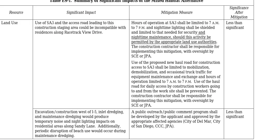
Table ES-1. Summary of Significant Impacts of the Mixed Habitat Alternative
Resource Significant Impact Mitigation Measure Significance After
Mitigation Land Use Use of SA3 and the access road leading to this
construction staging area could be incompatible with residences along Racetrack View Drive.
Hours of operation at SA3 shall be limited to 7 A.M. to 7 P.M. and nighttime lighting shall be shielded and limited to that needed for securityand nighttime maintenance, should this activity be permitted by the appropriate land use authorities. The construction contractor shall be responsible for implementing this mitigation, with oversight by SCE or JPA.
Use of the proposed new haul road for construction access to SA3 shall be limited to mobilization, demobilization, and occasional truck traffic for equipment maintenance and exchange and hours of operation limited to 7 A.M. to 7 P.M. Use of the haul road for daily access by construction workers going to and from the work site shall be prevented. The construction contractor shall be responsible for implementing this mitigation, with oversight by SCE or JPA.
Less than significant
Excavation/construction west of I-5, inlet dredging, and maintenance dredging would produce
temporary noise and night lighting impacts on residential areas along Sandy Lane. Additionally, periodic disruption of beach use would occur during maintenance dredging.
A public outreach/public comment program shall be developed by the applicant and approved by the appropriate affected agencies (City of Del Mar, City of San Diego, CCC, JPA).
Less than significant
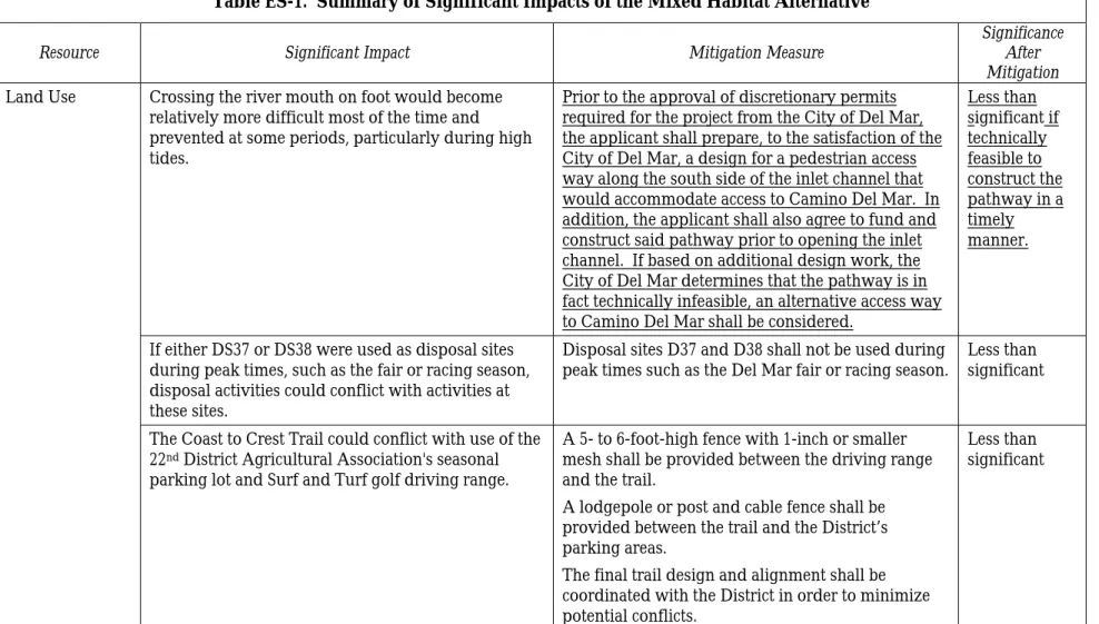
Table ES-1. Summary of Significant Impacts of the Mixed Habitat Alternative
Resource Significant Impact Mitigation Measure Significance After
Mitigation Land Use Crossing the river mouth on foot would become
relatively more difficult most of the time and prevented at some periods, particularly during high tides.
Prior to the approval of discretionary permits required for the project from the City of Del Mar, the applicant shall prepare, to the satisfaction of the City of Del Mar, a design for a pedestrian access way along the south side of the inlet channel that would accommodate access to Camino Del Mar. In addition, the applicant shall also agree to fund and construct said pathway prior to opening the inlet channel. If based on additional design work, the City of Del Mar determines that the pathway is in fact technically infeasible, an alternative access way to Camino Del Mar shall be considered.
Less than significant if technically feasible to construct the pathway in a timely manner.
If either DS37 or DS38 were used as disposal sites during peak times, such as the fair or racing season, disposal activities could conflict with activities at these sites.
Disposal sites D37 and D38 shall not be used during
peak times such as the Del Mar fair or racing season. Less than significant The Coast to Crest Trail could conflict with use of the
22nd District Agricultural Association's seasonal
parking lot and Surf and Turf golf driving range.
A 5- to 6-foot-high fence with 1-inch or smaller mesh shall be provided between the driving range and the trail.
A lodgepole or post and cable fence shall be provided between the trail and the District’s parking areas.
The final trail design and alignment shall be coordinated with the District in order to minimize potential conflicts.
Less than significant
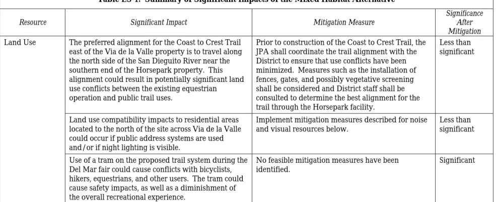
Table ES-1. Summary of Significant Impacts of the Mixed Habitat Alternative
Resource Significant Impact Mitigation Measure Significance After
Mitigation Land Use The preferred alignment for the Coast to Crest Trail
east of the Via de la Valle property is to travel along the north side of the San Dieguito River near the southern end of the Horsepark property. This alignment could result in potentially significant land use conflicts between the existing equestrian
operation and public trail uses.
Prior to construction of the Coast to Crest Trail, the JPA shall coordinate the trail alignment with the District to ensure that use conflicts have been minimized. Measures such as the installation of fences, gates, and possibly vegetative screening shall be considered and District staff shall be consulted to determine the best alignment for the trail through the Horsepark facility.
Less than significant
Land use compatibility impacts to residential areas located to the north of the site across Via de la Valle could occur if public address systems are used and/or if night lighting is visible.
Implement mitigation measures described for noise
and visual resources below. Less than significant Use of a tram on the proposed trail system during the
Del Mar fair could cause conflicts with bicyclists, hikers, equestrians, and other users. The tram could cause safety impacts, as well as a diminishment of the overall recreational experience.
No feasible mitigation measures have been
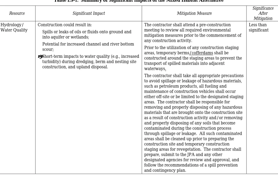
Table ES-1. Summary of Significant Impacts of the Mixed Habitat Alternative
Resource Significant Impact Mitigation Measure Significance After
Mitigation Hydrology/
Water Quality Construction could result in: § Spills or leaks of oils or fluids onto ground and into aquifer or wetlands;
§ Potential for increased channel and river bottom scour;
• Short-term impacts to water quality (e.g., increased turbidity) during dredging, berm and nesting site construction, and upland disposal.
The contractor shall attend a pre-construction meeting to review all required environmental mitigation measures prior to the commencement of any construction activity.
Prior to the utilization of any construction staging areas, temporary berms/cofferdams shall be constructed around the staging areas to prevent the transport of spilled materials into adjacent
waterways.
The contractor shall take all appropriate precautions to avoid spillage or leakage of hazardous materials, such as petroleum products, all fueling and
maintenance of construction vehicles shall occur either off-site or be limited to the designated staging areas. The contractor shall be responsible for removing and properly disposing of any hazardous materials that are brought onto the construction site as a result of construction activity and/or removing and properly disposing of any soils that become contaminated during the construction process through spillage or leakage. All such contaminated areas shall be cleaned up prior to preparing the construction site and temporary construction staging areas for revegetation. The contractor shall prepare, submit to the JPA and any other
designated agencies for review and approval, and follow the recommendations of a spill prevention and contingency plan.
Less than significant
Table ES-1. Summary of Significant Impacts of the Mixed Habitat Alternative
Resource Significant Impact Mitigation Measure Significance After
Mitigation Hydrology/
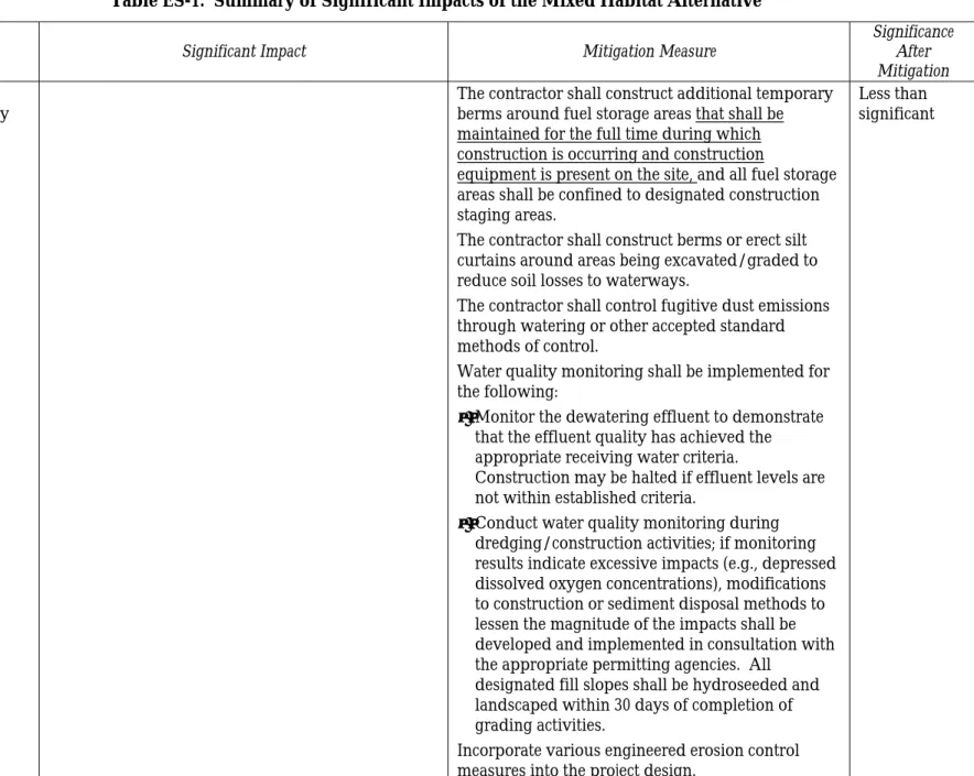
Water Quality The contractor shall construct additional temporary berms around fuel storage areas that shall be maintained for the full time during which
construction is occurring and construction
equipment is present on the site, and all fuel storage areas shall be confined to designated construction staging areas.
The contractor shall construct berms or erect silt curtains around areas being excavated/graded to reduce soil losses to waterways.
The contractor shall control fugitive dust emissions through watering or other accepted standard methods of control.
Water quality monitoring shall be implemented for the following:
• Monitor the dewatering effluent to demonstrate that the effluent quality has achieved the appropriate receiving water criteria.
Construction may be halted if effluent levels are not within established criteria.
• Conduct water quality monitoring during dredging/construction activities; if monitoring results indicate excessive impacts (e.g., depressed dissolved oxygen concentrations), modifications to construction or sediment disposal methods to lessen the magnitude of the impacts shall be developed and implemented in consultation with the appropriate permitting agencies. All
designated fill slopes shall be hydroseeded and landscaped within 30 days of completion of grading activities.
Incorporate various engineered erosion control measures into the project design.
Less than significant
Table ES-1. Summary of Significant Impacts of the Mixed Habitat Alternative
Resource Significant Impact Mitigation Measure Significance After
Mitigation Hydrology/
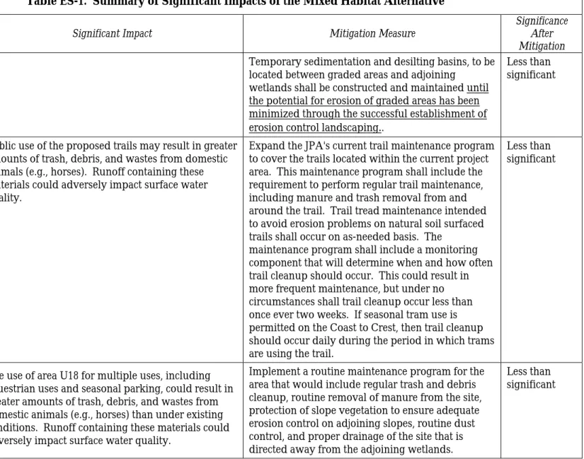
Water Quality Temporary sedimentation and desilting basins, to be located between graded areas and adjoining wetlands shall be constructed and maintained until the potential for erosion of graded areas has been minimized through the successful establishment of erosion control landscaping
.
.Less than significant
Public use of the proposed trails may result in greater amounts of trash, debris, and wastes from domestic animals (e.g., horses). Runoff containing these materials could adversely impact surface water quality.
Expand the JPA's current trail maintenance program to cover the trails located within the current project area. This maintenance program shall include the requirement to perform regular trail maintenance, including manure and trash removal from and around the trail. Trail tread maintenance intended to avoid erosion problems on natural soil surfaced trails shall occur on as-needed basis. The
maintenance program shall include a monitoring component that will determine when and how often trail cleanup should occur. This could result in more frequent maintenance, but under no circumstances shall trail cleanup occur less than once ever two weeks. If seasonal tram use is permitted on the Coast to Crest, then trail cleanup should occur daily during the period in which trams are using the trail.
Less than significant
The use of area U18 for multiple uses, including equestrian uses and seasonal parking, could result in greater amounts of trash, debris, and wastes from domestic animals (e.g., horses) than under existing conditions. Runoff containing these materials could adversely impact surface water quality.
Implement a routine maintenance program for the area that would include regular trash and debris cleanup, routine removal of manure from the site, protection of slope vegetation to ensure adequate erosion control on adjoining slopes, routine dust control, and proper drainage of the site that is directed away from the adjoining wetlands.
Less than significant
Table ES-1. Summary of Significant Impacts of the Mixed Habitat Alternative
Resource Significant Impact Mitigation Measure Significance After
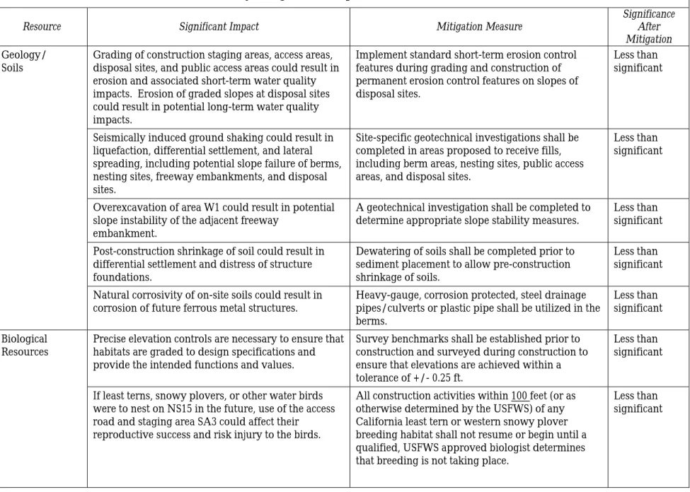
Mitigation Geology/
Soils Grading of construction staging areas, access areas, disposal sites, and public access areas could result in erosion and associated short-term water quality impacts. Erosion of graded slopes at disposal sites could result in potential long-term water quality impacts.
Implement standard short-term erosion control features during grading and construction of permanent erosion control features on slopes of disposal sites.
Less than significant
Seismically induced ground shaking could result in liquefaction, differential settlement, and lateral spreading, including potential slope failure of berms, nesting sites, freeway embankments, and disposal sites.
Site-specific geotechnical investigations shall be completed in areas proposed to receive fills, including berm areas, nesting sites, public access areas, and disposal sites.
Less than significant
Overexcavation of area W1 could result in potential slope instability of the adjacent freeway
embankment.
A geotechnical investigation shall be completed to
determine appropriate slope stability measures. Less than significant Post-construction shrinkage of soil could result in
differential settlement and distress of structure foundations.
Dewatering of soils shall be completed prior to sediment placement to allow pre-construction shrinkage of soils.
Less than significant Natural corrosivity of on-site soils could result in
corrosion of future ferrous metal structures. Heavy-gauge, corrosion protected, steel drainage pipes/culverts or plastic pipe shall be utilized in the berms.
Less than significant Biological
Resources Precise elevation controls are necessary to ensure that habitats are graded to design specifications and provide the intended functions and values.
Survey benchmarks shall be established prior to construction and surveyed during construction to ensure that elevations are achieved within a tolerance of +/- 0.25 ft.
Less than significant If least terns, snowy plovers, or other water birds
were to nest on NS15 in the future, use of the access road and staging area SA3 could affect their
reproductive success and risk injury to the birds.
All construction activities within 100 feet (or as otherwise determined by the USFWS) of any California least tern or western snowy plover breeding habitat shall not resume or begin until a qualified, USFWS approved biologist determines that breeding is not taking place.
Less than significant
Table ES-1. Summary of Significant Impacts of the Mixed Habitat Alternative
Resource Significant Impact Mitigation Measure Significance After
Mitigation Biological
Resources If California least terns or western snowy plovers are breeding, all construction activities within 100 feet (or as otherwise determined by the USFWS) of the active breeding sites shall be postponed until breeding activities have finished (approximately September 15 or as otherwise determined by surveys and the USFWS).
Potential impacts of staging areas and haul routes include the removal of existing vegetation, disruption of wildlife use — including possible nesting on NS15 — alteration of soil and drainage characteristics, and construction-related spills. Although the project commits to restoration of these areas, plans to accomplish this are only generally developed. Final details should be addressed during permitting for the project. Impacts are considered potentially
significant but mitigable by confining ground disturbance, parking, and maintenance/ refueling activities to areas that are of lowest value to wildlife and can most easily be restored following
construction, and by avoiding the use of areas where sensitive bird species are nesting.
Proposed construction staging areas and haul routes shall be located within the footprint of marsh restoration and the overlap of existing wetlands minimized wherever possible. To achieve this, the following modifications to proposed staging areas and haul routes shall be incorporated into the final grading plans:
• The haul route that passes east-west under I-5 shall be located as far to the south as possible to avoid the population of Coulter's goldfields on the west side of the bridge and the existing tidal channel east of the bridge. The haul route and water control structure on the southwest side of I-5 shall be placed in ruderal habitat on the berm west of the bridge.
Less than significant
The water control structure for haul route to DS38 would temporarily disrupt tidal flows and constrict the area of passage for aquatic organisms. Frequent use of the structure by trucks hauling sediment to DS38 would also disturb fish and wildlife in the vicinity.
• Staging Area SA3 shall be reconfigured as close as possible to the toe of the I-5 embankment to avoid existing seasonal wetlands.
• Staging Area SA4 shall be relocated into the W4 wetland restoration footprint and adjacent ruderal habitat, avoiding areas of seasonal wetlands to the west.
Less than significant
Table ES-1. Summary of Significant Impacts of the Mixed Habitat Alternative
Resource Significant Impact Mitigation Measure Significance After
Mitigation Biological
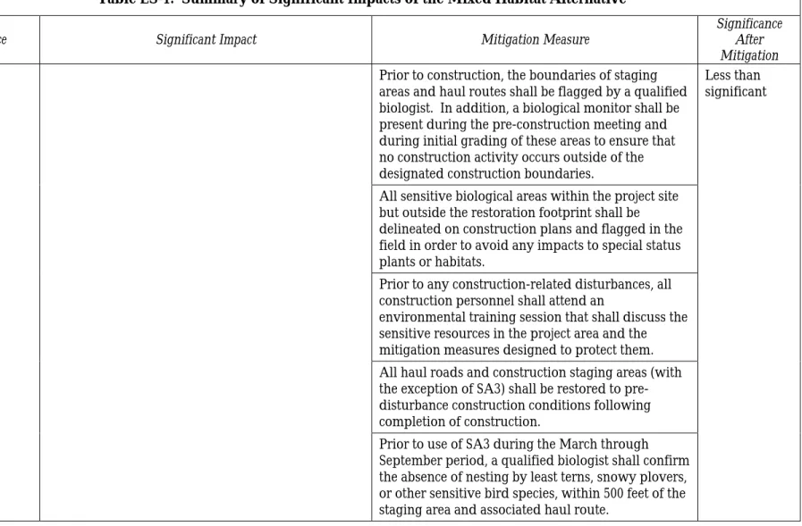
Resources Prior to construction, the boundaries of staging areas and haul routes shall be flagged by a qualified biologist. In addition, a biological monitor shall be present during the pre-construction meeting and during initial grading of these areas to ensure that no construction activity occurs outside of the designated construction boundaries.
Less than significant
All sensitive biological areas within the project site but outside the restoration footprint shall be delineated on construction plans and flagged in the field in order to avoid any impacts to special status plants or habitats.
Prior to any construction-related disturbances, all construction personnel shall attend an
environmental training session that shall discuss the sensitive resources in the project area and the mitigation measures designed to protect them. All haul roads and construction staging areas (with the exception of SA3) shall be restored to pre-disturbance construction conditions following completion of construction.
Prior to use of SA3 during the March through September period, a qualified biologist shall confirm the absence of nesting by least terns, snowy plovers, or other sensitive bird species, within 500 feet of the staging area and associated haul route.
Table ES-1. Summary of Significant Impacts of the Mixed Habitat Alternative
Resource Significant Impact Mitigation Measure Significance After
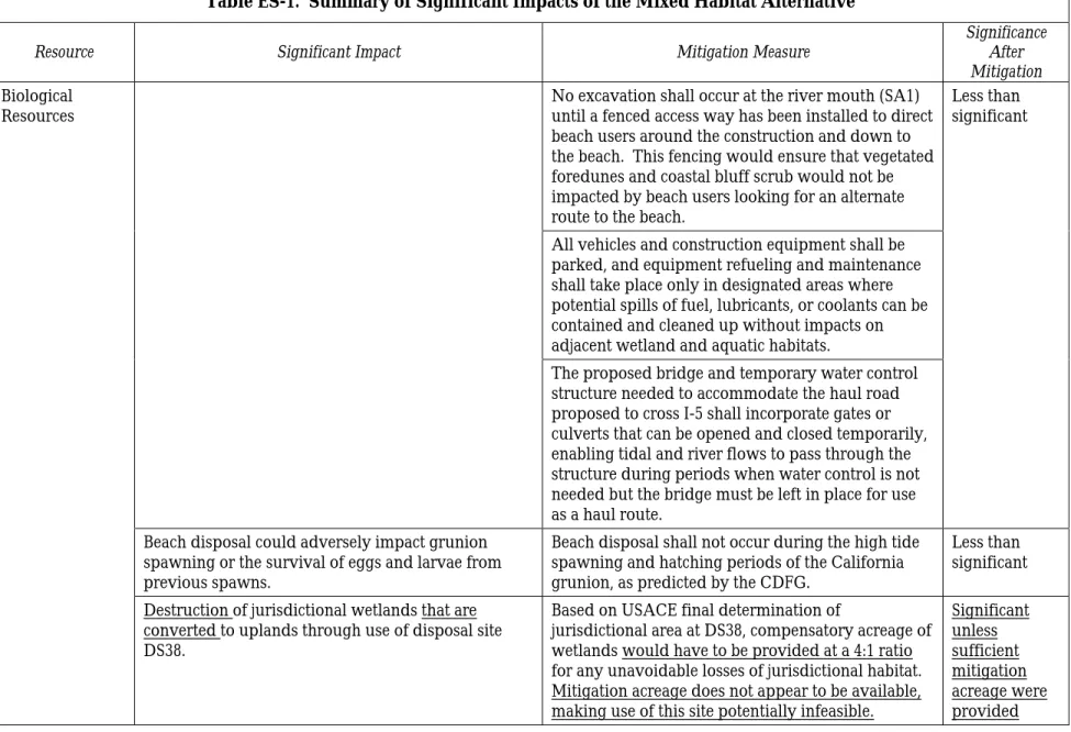
Mitigation Biological
Resources No excavation shall occur at the river mouth (SA1) until a fenced access way has been installed to direct beach users around the construction and down to the beach. This fencing would ensure that vegetated foredunes and coastal bluff scrub would not be impacted by beach users looking for an alternate route to the beach.
Less than significant
All vehicles and construction equipment shall be parked, and equipment refueling and maintenance shall take place only in designated areas where potential spills of fuel, lubricants, or coolants can be contained and cleaned up without impacts on adjacent wetland and aquatic habitats.
The proposed bridge and temporary water control structure needed to accommodate the haul road proposed to cross I-5 shall incorporate gates or culverts that can be opened and closed temporarily, enabling tidal and river flows to pass through the structure during periods when water control is not needed but the bridge must be left in place for use as a haul route.
Beach disposal could adversely impact grunion spawning or the survival of eggs and larvae from previous spawns.
Beach disposal shall not occur during the high tide spawning and hatching periods of the California grunion, as predicted by the CDFG.
Less than significant Destruction of jurisdictional wetlands that are
converted to uplands through use of disposal site DS38.
Based on USACE final determination of
jurisdictional area at DS38, compensatory acreage of wetlands would have to be provided at a 4:1 ratio for any unavoidable losses of jurisdictional habitat. Mitigation acreage does not appear to be available, making use of this site potentially infeasible.
Significant unless sufficient mitigation acreage were provided
Table ES-1. Summary of Significant Impacts of the Mixed Habitat Alternative
Resource Significant Impact Mitigation Measure Significance After
Mitigation Biological
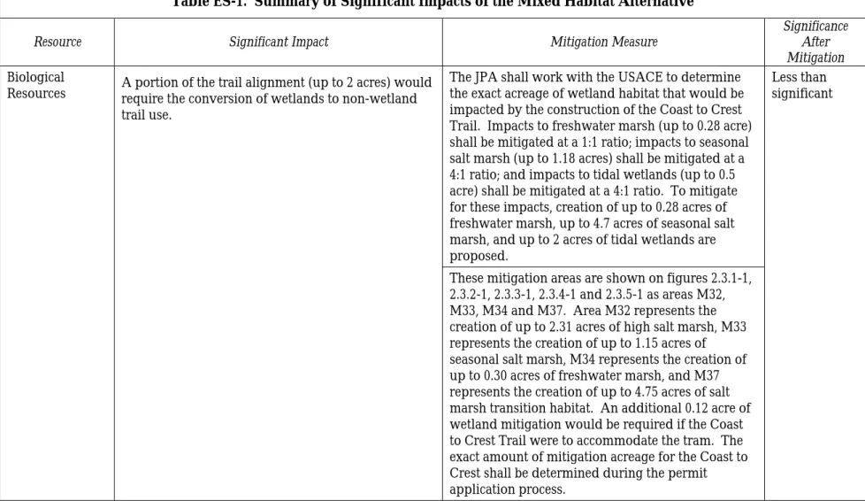
Resources A portion of the trail alignment (up to 2 acres) would require the conversion of wetlands to non-wetland trail use.
The JPA shall work with the USACE to determine the exact acreage of wetland habitat that would be impacted by the construction of the Coast to Crest Trail. Impacts to freshwater marsh (up to 0.28 acre) shall be mitigated at a 1:1 ratio; impacts to seasonal salt marsh (up to 1.18 acres) shall be mitigated at a 4:1 ratio; and impacts to tidal wetlands (up to 0.5 acre) shall be mitigated at a 4:1 ratio. To mitigate for these impacts, creation of up to 0.28 acres of freshwater marsh, up to 4.7 acres of seasonal salt marsh, and up to 2 acres of tidal wetlands are proposed.
Less than significant
These mitigation areas are shown on figures 2.3.1-1, 2.3.2-1, 2.3.3-1, 2.3.4-1 and 2.3.5-1 as areas M32, M33, M34 and M37. Area M32 represents the creation of up to 2.31 acres of high salt marsh, M33 represents the creation of up to 1.15 acres of seasonal salt marsh, M34 represents the creation of up to 0.30 acres of freshwater marsh, and M37 represents the creation of up to 4.75 acres of salt marsh transition habitat. An additional 0.12 acre of wetland mitigation would be required if the Coast to Crest Trail were to accommodate the tram. The exact amount of mitigation acreage for the Coast to Crest shall be determined during the permit application process.
Table ES-1. Summary of Significant Impacts of the Mixed Habitat Alternative
Resource Significant Impact Mitigation Measure Significance After
Mitigation Biological
Resources If inlet maintenance ceases, populations of tidal marsh plants, invertebrates, fish, and wildlife that become established in the restored, fully tidal system could be adversely affected by inlet closure and the resulting deterioration of water quality.
Prior to the approval of the San Dieguito Wetland Restoration project by the JPA, the JPA shall enter into an agreement with SCE that would provide the legal and financial guarantees necessary to ensure that the inlet will be maintained in an open condition in perpetuity and the restored wetland will continue to attain the biological benefits described in section 4.4.
Less than significant
Areas near the river mouth would be disturbed during wetland construction and subjected
intermittently to disturbance in conjunction with inlet maintenance. Disturbance would include both the direct effects of equipment operation and the indirect effects of redirected foot traffic.
Impacts on these sensitive habitats are potentially significant but mitigable by confining activities to areas of lowest biological value and providing public access along pre-existing trails where native vegetation would not be impacted.
Less than significant
A significant increase in the turbidity of the water associated with construction may temporarily reduce foraging success of terns using the lagoon area during the construction period. The disruption of least tern foraging or breeding activities would be a significant impact that could be mitigated by the avoidance of construction activities within 500 feet of nesting birds, and the installation of sediment fencing around work areas and other erosion control
measures (described under the water quality mitigation section) to control erosion and limit turbidity.
See Hydrology/Water Quality above. Less than
Table ES-1. Summary of Significant Impacts of the Mixed Habitat Alternative
Resource Significant Impact Mitigation Measure Significance After
Mitigation Biological
Resources If breeding on the site occurred during construction, least Bell's vireo could be adversely affected. Least Bell’s vireo presence/absence surveys shall be conducted in the spring by a qualified, USFWS approved biologist. Surveys shall take place in the riparian habitat in the southeastern part of the property prior to the commencement of any activities within 500 feet of that area. If this species is present during its breeding season, grading and other intense activity associated with habitat restoration within 200 feet, or as otherwise
determined by the USFWS, of the breeding habitat shall be scheduled to occur outside the least Bell’s vireo breeding season (approximately March 15 through September).
Less than significant
Possible disturbance of Belding's savannah sparrow
during nesting season. Belding’s savannah sparrow presence/absence surveys shall be conducted in the spring by a qualified, USFWS approved biologist in all suitable habitat within the project area. Construction staging, excavation, dredging, disposal sites use, and berm creation shall be scheduled to occur outside the breeding season for Belding’s savannah sparrow (March 1 to August 1) for all activities that would occur in or within 100 feet of habitat known to support Belding’s savannah sparrow breeding. Obtain CDFG incidental take permit as required.
Less than significant
Table ES-1. Summary of Significant Impacts of the Mixed Habitat Alternative
Resource Significant Impact Mitigation Measure Significance After
Mitigation Biological
Resources Predation on least tern or snowy plover nests could be increased, or nesting could be discouraged, by fences, structures, bushes, or public access that is too close to the nest sites.
California least tern and western snowy plover breeding habitat created onsite shall include the following characteristics:
• The nesting sites shall be monitored to address fencing and potential predation issues. If least terns begin using the nesting sites, the nesting attempts shall be monitored to determine if predation is a problem, and if so, whether it is mammalian or avian in origin, and appropriate measures shall be taken to eliminate any future predation.
• Large shrubs or man-made structures that could be used as perches by predators shall not be allowed on the berms near the nest sites.
• Fencing shall not be installed initially around the nesting sites west of the highway, and shall be based on monitoring studies on the incidence of predators following construction.
• The nesting sites shall be monitored to address fencing and potential predation issues. If least terns begin using the nesting sites, the nesting attempts shall be monitored to determine if predation is a problem, and if so, whether it is mammalian or avian in origin.
Less than significant
Table ES-1. Summary of Significant Impacts of the Mixed Habitat Alternative
Resource Significant Impact Mitigation Measure Significance After
Mitigation Biological
Resources If the use of fencing is unavoidable (to exclude mammalian predators), the following measures shall be required as part of the fence installation: fencing shall be installed at the base of elevated breeding habitat or if there is no elevation
difference, at a distance to eliminate vantage sites for avian predators; materials that are mechanical deterrents to perching shall be installed on top of the fence. If these measures do not solve the problem, additional measures shall be used, such as protection of individual nests, and trapping and relocation of problem predator birds.
Less than significant
Public access points (trails or lookouts) shall not be constructed within 100 feet of any tern nest site. Trails or access points shall be temporarily closed if terns nest within that distance.
Possible elimination of local populations of non-listed sensitive plant species (southern tarplant, Coulter's goldfields, Del Mar sand aster, woolly seablite) if restoration activities cannot avoid sites supporting them.
• Non-listed, sensitive plant species shall be avoided to the maximum extent possible. Where impacts cannot be avoided, seed shall be salvaged from impacted plants and an attempt shall be made to reestablish populations in suitable habitat. Restoration efforts onsite shall use seed collected from the site, where feasible.
Table ES-1. Summary of Significant Impacts of the Mixed Habitat Alternative
Resource Significant Impact Mitigation Measure Significance After
Mitigation Biological
Resources A habitat restoration and monitoring plan, including success criteria that recognize the
experimental nature of such transplantation, shall be prepared for any reestablishment effort. This plan shall include the following details for sensitive plant species:
• Restoration efforts shall plan to establish the Southern tarplant populations on spoil disposal areas, as this species appears tolerant of saline compacted soils. The species shall be included in the proposed seed and plant mix for use in freshwater marsh transitional vegetation. In order to obtain viable seed, the plants shall not be impacted until the seed has been allowed to mature.
• Restoration efforts shall plan to establish the Coulter’s Goldfields populations in areas of salt marsh playas and fringing areas that receive seasonal rainwater flushing that reduces soil salinity. The species shall be included in the proposed seed and plant mix for use in upland restoration of the site. In order to obtain viable seed, the plants shall not be impacted until the seed has been allowed to mature.
Less than significant
• Impacts to the red sand-verbena colony onsite would be considered locally significant and therefore, the area occupied by the red sand-verbena shall be fenced to prevent inadvertent impacts to these plants and their habitat.
Table ES-1. Summary of Significant Impacts of the Mixed Habitat Alternative
Resource Significant Impact Mitigation Measure Significance After
Mitigation Biological
Resources • If individual Lewis’s evening primrose plants are impacted, this species shall be included in the proposed seed and plant mix for use in similar habitat on conserved lands; seed shall be collected from Penasquitos Lagoon, which supports the only large population in the County.
• If individual Del Mar Mesa sand aster plants are impacted, this species shall be included in the proposed seed and plant mix to reestablish the plant on a nearby site on suitable habitat containing sandstone. Seed collection from existing plants on site shall occur to support the inclusion of local genotypes of this species in the revegetation seed and plant mix for coastal sage scrub and chaparral.
• Where larger populations of woolly seablite (Suaeda) cannot be avoided, plants shall be salvaged for propagation or transplanted into a suitable protected location.
Disruption of breeding by sensitive non-listed bird
species. To avoid impacts to sensitive bird species that potentially nest in the upland habitat within the project boundaries (including California Species of Special Concern species such as loggerhead shrike, burrowing owl, and northern harrier), surveys shall be conducted by a qualified biologist during the appropriate breeding season for each species. Survey results will determine the need for
construction setbacks from nests to reduce impacts to breeding success.
Less than significant
Table ES-1. Summary of Significant Impacts of the Mixed Habitat Alternative
Resource Significant Impact Mitigation Measure Significance After
Mitigation Biological
Resources Destruction of burrows occupied by burrowing owls. If burrowing owl burrows are disturbed during construction activities suitable (burrow) habitat shall be created. Any impact to occupied burrowing owl burrows would be considered locally significant and shall require the creation of artificial burrows in suitable habitat that is destined for long-term preservation. Burrowing owls shall either be passively relocated or captured and released at the preserved site. Relocation shall occur in the non-breeding season to avoid impacts to eggs, nestlings, or dependent juveniles.
Less than significant
Disruption of nesting by sensitive riparian bird
species. To avoid impacts to sensitive bird species that potentially nest in the riparian or wetland habitat within or near the project boundaries (including California Species of Special Concern species such as yellow-breasted chat, Cooper’s hawk, and tricolored blackbird and Fully Protected species such as the white-tailed kite), surveys shall be conducted by a qualified biologist during the appropriate breeding season for each species. All initial disturbances to riparian or wetland
vegetation within 250 feet of known breeding sites for these species shall occur prior to February 15 or after July 15.
Less than significant
Mortality to sensitive (non-listed) wildlife species
during construction. All wildlife in harm’s way during construction, including individual southwestern pond turtles, shall be collected and relocated to suitable habitat by a biological monitor.
Less than significant
Table ES-1. Summary of Significant Impacts of the Mixed Habitat Alternative
Resource Significant Impact Mitigation Measure Significance After
Mitigation Natural
Resources Use of DS32 would result in the loss of 43 acres of Prime Farmland. The use of DS33, DS34, and DS35 and construction of the 25-car parking lot would impact about 45 acres of land that are under cultivation and about 34 acres of land classified as Farmland of Statewide Importance. The use of offsite disposal area DS36 would displace 24 acres of land that are under cultivation and 26 acres that are classified as Farmland of Statewide Importance.
No feasible measures have been identified. It is only through the selection of an array of disposal site options that do not include DS32, DS33, DS34, DS35, and DS36 that the impacts to important farmland at these sites would be avoided.
Significant
Landform Alteration/ Visual Quality
The filling of DS32, DS33, DS34, DS35, DS36, and DS38 would result in a significant impact to natural landforms (Landform Alteration).
Impacts associated with landform alteration are only mitigable through a redesign of the project to reduce the amount of fill relocated to any one spot within the project boundaries or by eliminating one or more of the disposal sites from the list of
potential options. Unless redesigned or eliminated, the grading proposed at disposal sites DS32, DS33, DS34, DS35, DS36 and DS38 would be considered significant and unmitigated.
Less than significant if project is redesigned
If the parking lot at DS37 were not landscaped in association with resurfacing following disposal, the expanse of asphalt that would be used to resurface the site would be more noticeable from the roadway than that which currently exists (Visual Quality).
The area shall be landscaped in accordance with a landscape plan, approved by the CCC. This landscaping plan shall be implemented in
association with the resurfacing of the parking area.
Less than significant
The stone revetment along the toe of the longest berm (in Area B8) and Stone Revetments 1 and 2 would cause an adverse visual impact (Visual Quality).
Those rocks that would be exposed and visible to the public in Stone Revetments 1, 2, and 3 shall be of a color that will blend in with the natural color of the soils in the area.
Less than significant The articulated concrete block (ACB) mats above the
stone revetment for berm B8 would cause an adverse visual impact (Visual Quality).
The ACB mats and the surrounding area shall be revegetated, as described in section 2.3.1.4.4, and monitored by the CCC in accordance with permit conditions.
Less than significant
Table ES-1. Summary of Significant Impacts of the Mixed Habitat Alternative
Resource Significant Impact Mitigation Measure Significance After
Mitigation Landform
Alteration/ Visual Quality
When considered as a separate project element, all three berms would result in an adverse impact to landforms due to their height and the amount of fill required (Landform Alteration).
It is not feasible from a hydrologic perspective to reduce the amount of grading required to construct the proposed berms.
Significant
Nesting sites NS11, NS12, and NS14 would require more than 2,000 cubic yards of earth and sand per acre and would have an elevation more than 10 feet above the finished grade (Landform Alteration)
.
No feasible mitigation measures have been
identified. Significant
The light-colored plateaus of the new nesting sites (excluding NS15) would contrast noticeably with the surrounding area, particularly when seen from higher elevations (Visual Quality).
No feasible mitigation measures have been
identified. Significant
Earthmoving/construction activities would have an adverse visual impact for between 2 and 4 years until the vegetation is established (Visual Quality).
No feasible mitigation measures have been
identified to reduce impacts during this time period. Significant The Nature/Interpretive Center would be visually
compatible with the adjacent commercial
development, but would restrict views of the river valley from a portion of Via de la Valle (Visual Quality).
The form, mass, and profile of all structures and architectural features shall be designed to blend with the surrounding terrain.
Materials, finishes, and colors of the main building, accessory structures, and any walls or fences shall be compatible with the intent of minimizing the visibility of the project. Colors shall be limited to subtle earthtone hues, with style and texture that reflects traditional/rural character of the river valley. All glass shall be non-reflective.
Less than significant
Table ES-1. Summary of Significant Impacts of the Mixed Habitat Alternative
Resource Significant Impact Mitigation Measure Significance After
Mitigation Landform
Alteration/ Visual Quality
Grading associated with the construction of the Nature Center shall be designed so as to reduce the need for manufactured slopes visible from open space areas.
Parking areas shall be sited and/or landscaped to minimize visibility from major roadways and sensitive viewsheds.
Native species shall be the predominant plant material used in and around park facilities. Night lighting shall be minimized to that required for security/safety purposes.
Structures shall be oriented on the site in a manner that minimizes the blockage of views from adjoining public areas.
Table ES-1. Summary of Significant Impacts of the Mixed Habitat Alternative
Resource Significant Impact Mitigation Measure Significance After
Mitigation Landform
Alteration/ Visual Quality
The use of area U18 for temporary parking, truck trailer storage, show barns and/or practice tracks, and/or uncovered show rings also could block some or all of the views of the river valley from Via de la Valle (Visual Quality).
To mitigate visual impacts from potential use of area U18 by the District, the District shall prepare a site design for the specific use(s) proposed on the site. The site design shall incorporate the above outlined measures described for the
Nature/Interpretive Center. In addition, if the site is to be used for seasonal parking, the District shall prepare a landscape plan that addresses the visual appearance of the parking area during the rest of the season. The land exchange agreement between the District and the JPA, if prepared, shall limit any future use of the property to the specific use(s) stated in the agreement. The specific site design shall be evaluated to fully assess potential visual impacts as part of the subsequent environmental review process that is required to address potential traffic impacts from such uses. The determination of whether or not potential impacts to visual quality from the specific proposal are mitigated to below a level of significance would occur as part of
subsequent environmental review.
Unknown
Traffic/
Circulation During construction periods of heavy truck traffic, in combination with periods of seasonal traffic congestion in the region (during the Del Mar Fair, thoroughbred racing season, or high summer beach use), the project could increase traffic congestion to significant levels within roadways adjacent to the site.
Implement a traffic management plan that would minimize project-generated truck traffic on
roadways adjacent to the site during peak seasonal traffic periods. The traffic plan shall also include measures to accommodate the movement of trucks to and from the project site during periods of intense truck activity, such as using flagmen and installing warning signs to notify motorists of the presence of truck activity.
Less than significant