Original Research Paper
Evaluation of navigation performances of GPS
devices near interchange area pertaining to
wrong-way driving
Mohammad Jalayer
a,*, Huaguo Zhou
b, Beijia Zhang
baCenter for Advanced Infrastructure and Transportation (CAIT), Rutgers, The State University of New Jersey, Piscataway, NJ 08854, USA
bDepartment of Civil Engineering, Auburn University, Auburn, AL 36849, USA
a r t i c l e i n f o
Article history:
Received 24 May 2016 Received in revised form 14 July 2016
Accepted 19 July 2016
Available online 10 November 2016
Keywords: Wrong-way driving Exit ramp Interchange GPS device Navigation app
a b s t r a c t
Based on past studies, exit ramp terminals are the common locations for drivers to enter a physically separated highway in the wrong direction. Currently, many drivers, especially nonlocal drivers, often rely on voice-guided navigation apps and Global Positioning System (GPS) devices to navigate their routes on and off freeways. A few studies have reported that GPS devices sometimes give drivers wrong information and cause wrong-way entry into a freeway, especially at some confusing interchanges, such as partial cloverleaf and com-pressed diamond interchanges. The access points located close to exit ramps may also cause a problem for GPS devices in sending accurate voice-guidance. It is unknown if current GPS devices are capable of properly informing drivers regarding turning move-ments in advance of exit ramp terminals at some common interchanges. The objective of this study is to evaluate the most commonly used GPS devices/navigation apps to identify existing problems and their potential for reducing wrong-way driving (WWD) incidents at interchange terminals. Field experiments were conducted at 10 common freeway in-terchanges or inin-terchanges with nearby access driveways in the state of Alabama. Results show that most GPS devices have difficulty in providing correct guidance when the spacing between an access point and an exit ramp is less than 300 feet. Our comparison of five different GPS devices used on the same routes reveals that navigation apps have more limitations in guiding drivers than stand-alone GPS devices. Recommendations are offered to help GPS mapping companies improve their devices or add new features to reduce the occurrence of WWD.
©2016 Periodical Offices of Chang'an University. Publishing services by Elsevier B.V. on behalf of Owner. This is an open access article under the CC BY-NC-ND license (http:// creativecommons.org/licenses/by-nc-nd/4.0/).
*Corresponding author. Tel.:þ1 312 351 4730.
E-mail addresses:[email protected](M. Jalayer),[email protected](H. Zhou),[email protected](B. Zhang). Peer review under responsibility of Periodical Offices of Chang'an University.
Available online at
www.sciencedirect.com
ScienceDirect
journal homepage:w ww.elsevier.com/locat e/jtte
http://dx.doi.org/10.1016/j.jtte.2016.07.003
2095-7564/©2016 Periodical Offices of Chang'an University. Publishing services by Elsevier B.V. on behalf of Owner. This is an open access article under the CC BY-NC-ND license (http://creativecommons.org/licenses/by-nc-nd/4.0/).
1.
Introduction
Interchanges are critical elements of freeway and highway systems, providing access to nearby urban, suburban, and rural areas. This access stimulates land use developments in close proximity to the interchanges, and as a result, multiple driveways/access points (e.g., hotel, gas stations, and fast food restaurants) appear nearby (Butorac and Wen, 2004). Side streets or access driveways in the immediate vicinity of interchanges may lead drivers to enter exit ramps and drive in the wrong direction. Wrong-way driving (WWD) is defined as movement against the main stream of traffic on physically divided facilities such as interstates, freeways, and expressways and their access points (Baratian-Ghorghi et al., 2015). An analysis of crash data extracted from the Fatality Analysis Reporting System (FARS) from 2004 to 2011 revealed that an average annual total of 359 people were killed in 269 fatal WWD crashes (NHTSA, 2016). The average number of fatalities per WWD fatal crash was 1.33, as compared to the 1.09 fatalities rate for all other fatal roadway crashes (NHTSA, 2016). In order to mitigate the possibility and severity of WWD crashes, many different countermeasures have been implemented by state Departments of Transportation (DOTs) and local agencies. These countermeasures include traffic signs, pavement markings, traffic signals, road geometric design, and intelligent transportation systems (ITS). Although human-related factors are considered as the main contributors to WWD, a previous study showed that some interchange types (e.g., partial cloverleaf) are highly susceptible to WWD (Morena and Leix, 2012). Moreover, proper application of access management techniques (e.g., exit and entrance ramps, frontage roads, and raised medians) in the vicinity of interchanges not only facilitates movement but also improves the safety of road users (Pour-Rouholamin et al., 2014a).
It is now common for drivers to have voice-guided navi-gation apps and Global Positioning System (GPS) units in their vehicles to help navigate their routes, especially nonlocal drivers. A GPS is a satellite-based positional system composed of a network of 24 satellites placed into orbit by the U.S. Department of Defense (Hoffmann-Wellenhof et al., 1994). Based on a national survey conducted in 2013, more than 50 percent of U.S. drivers used GPS devices, smartphones, and tablets to navigate their routes (HIM, 2015). These devices commonly include various features (e.g., mapping and routing, and real-time traffic) and provide turn-by-turn driving directions, but the accuracy of positioning is rapidly becoming recognized as the most severe limitation of GPS performance. Every day, many drivers use GPS devices to navigate movement on and off freeways, but it is not clear how these devices inform drivers audibly on turning movements just before they approach exit ramp terminals.
This paper evaluates the potential of GPS devices and navigation apps that use turn-by-turn voice guidance to warn or mislead drivers in advance of exit ramp terminals. Field data were collected at 10 common freeway interchanges in the state of Alabama. The results of this study provide valuable information for GPS mapping companies to refine their
mapping software and add a new function to GPS systems to promptly send wrong-way warning messages to drivers who go the wrong way. Additionally, this study can help re-searchers and DOTs redesign their access management pol-icies in the vicinity of interchanges to improve the accuracy of commonly used GPS devices.
2.
Literature review
Based on six years of crash data,Zhou et al. (2012b)identified several factors contributing to WWD crashes on Illinois freeways. They concluded that on freeways, most entry points for WWD are exit ramps at interchange areas. Moreover, based on the analysis results, compressed diamond and diamond interchanges were the top two interchange types for wrong-way crash entry points. Previous studies have concluded that driving under the influence, older drivers, and driving fatigue were the primary causes of wrong-way crashes (Copelan, 1989; Moler, 2002; NTTA, 2009). Other studies have shown that poor lighting conditions and insufficient signage and pavement marking at interchanges could also be contributing factors to wrong-way crashes (Braam, 2006; Vicedo, 2006). In a joint study between the Michigan Department of Transportation (MDOT) and the Federal Highway Administration (FHWA),
Morena and Leix (2012) researched the characteristics of WWD crashes on Michigan freeways. The study results determined that partial cloverleaf interchanges were the origination points for 60% of WWD crashes with known entry points but represented only 21% of the total types of interchanges in Michigan. In 2014, the Illinois Department of Transportation (IDOT) published a guideline for reducing wrong-way crashes on freeways to provide guidance for implementing traditional and advanced safety countermeasures, and to achieve a significant reduction in the number of WWD incidents and crashes on freeways. These countermeasures included signs (e.g., DO NOT ENTER signs), pavement markings (e.g., in-line arrows), traffic signals, and geometric design improvements (Zhou and Pour-Rouholamin, 2014). Also in 2014, theAmerican Traffic Safety Services Association (ATSSA), published an executive summary booklet of various case studies to provide transportation practitioners with a good understanding of WWD incidents and emerging safety countermeasures, primarily for exit ramps. These countermeasures were categorized into two major groups: (1) signage, pavement marking, and multiple devices, and (2) geometric design (Zhou and Pour-Rouholamin, 2014). Seitzinger et al. (2016)
evaluated the traffic sign mounted height for preventing WWD using a driver simulator. The study results confirmed that for potential wrong-way left turns, the low-mounted signs improved the drivers' reaction time by 21% and decreased the probability of missing a sign from 19% to 3%. Another study conducted by the Washington State Department of Transportation (WSDOT) revealed that a large proportion of WWD crashes originated from one specific exit ramp on a parclo interchange (Leduc, 2015; Moler, 2002).
GPS devices are widely employed in transportation areas for the purposes of route guidance, vehicle fleet management
and monitoring, mapping of transportation networks, traffic incident management, road network monitoring, and as in-formation systems for ambulance tracking (Mintsis et al., 2004). GPS is an essential element in the future of ITS (GPS, 2016). According to the American Public Transportation Association (APTA), significant WWD issues occur when errant drivers travel on exclusive-use lanes, high-occupancy vehicle (HOV) lanes, counter-flow lanes, bridges or subway portals, or on ballasted railroad tracks instead of pavement. The number of these incursions has risen with the proliferation of automotive GPS navigation systems, which sometimes show a route or a turn onto a roadway that is proximate to an exclusive-use lane or railroad track that a driver takes by mistake, especially when there is a verbal command to“turn right” or“make a U-turn”when a car is on an activated grade crossing (APTA, 2016).
According to the Federal Aviation Administration (FAA) in 2014, the horizontal accuracy of the GPS standard positioning service (SPS) is often within 1 m (GPS Roads and Highways, 2016). Various factors can affect the accuracy of GPS devices, including, but not limited to, the quality of the GPS receiver, satellite positions, and landscape characteristics.Weih et al. (2009) used root mean square error (RMSE) analysis to evaluate the accuracy of seven GPS receivers, including four Garmin and three Trimble devices, at thirty-three ground control points (eleven in a forest landscape, eleven near buildings, and eleven with clear unobstructed sky) in the University of Arkansas in Monticello. The study results showed that the accuracy of the Garmin receivers were consistent, and those of the Trimbles varied between 2.52 and 18.42 m. Based on a recently conducted online survey by Harris Interactive in April 2013, more than 60% of U.S. drivers who used GPS units confirmed that this technology made them confused at least once and pointed them into the wrong direction an average of 4.4 times (HIM, 2015). The analysis results also indicated that 46% of U.S. drivers still use road maps, printed directions, guidebooks, and atlases in their cars to navigate. Moreover, compared to women, male drivers use GPS devices 9% more often to travel to new locations. Geographically, GPS devices are more frequently used by drivers in the Northeast (35%) compared to drivers in the Western U.S. (25%) (HIM, 2015).
Based upon a comprehensive literature review ( Baratian-Ghorghi et al., 2014, 2015; Cooner and Ranft, 2008; Finley et al., 2014a, 2014b; Kemel, 2015; Lathrop et al., 2010; Morena and Leix, 2012; NHTSA, 2016; NTSB, 2012; Ponnaluri, 2016; Pour-Rouholamin et al., 2014a, 2014b; Scaramuzza and Cavegn, 2007; Xing, 2014; Zhou et al., 2012a,b, 2014;Zhou and Pour-Rouholamin, 2014), it can be noted that although there is a considerable number of studies on WWD, especially with respect to safety countermeasures, none have focused on the role of GPS devices in misleading drivers and causing WWD incidents, which we addressed in this paper.
3.
Method and data
Recently, advanced methods have been utilized to gather data in the field of traffic safety (Jalayer et al., 2014; Zhou et al., 2013; Sharifi and Shabaniverki, 2016; Khalilikhah et al., 2016),
traveler and driver behaviors (Sharifi et al., 2015; Baratian-Ghorghi and Zhou; 2016), transportation planning ( Soltani-Sobh et al., 2015a,b; Asgari et al., 2016), and assess manage-ment (Khalilikhah et al., 2016; Gong et al., 2012; Balali and Golparvar-Fard, 2015; Khalilikhah and Heaslip, 2016). In order to quantify the threshold/accuracy of GPS devices, a proper scenario must first be established. For each field test in our study, the final destination was set to be an address located along a driveway next to an exit ramp. A driver may make a wrong-way right turn onto an exit ramp if the GPS device audibly informs drivers to turn right before exit ramps. In this study, a“failure event”is identified as the spacing between the side street/access point and an exit ramp being shorter than the GPS threshold. This threshold, which is measured in the field test, is defined as the distance within which each GPS device informs drivers for the last time regarding turning movements. In other words, a failure event occurs when a GPS device gently announces a turning movement right before the exit ramp, thus leading a driver to go the wrong-way.
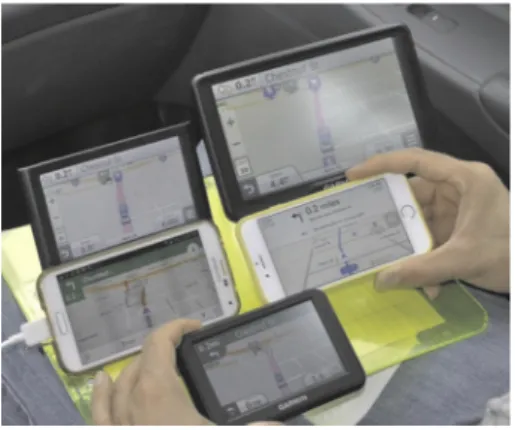
In this study, we evaluated five different GPS devices/ navigation apps, including: (1) iPhone 6 Apple Maps (iOS sys-tem), (2) Garmin Nuvi 2557, (3) Garmin Nuvi 2797, (4) Garmin Nuvi 40, and (5) Galaxy S5 Google Maps (Android system) (Fig. 1). Google launched Google Maps in 2005, and within six months the company's shares increased about 50%, indicating its almost immediate popularity and widespread use. The features in the Google Maps app on Android and iOS systems include, but not limited to, turn-by-turn navigation, street-level view, offline map view, and driving, transit, biking, and walking directions. In 2012, Google Maps was replaced by Apple Maps on all Apple iOS products, which has the capability of providing 3D views. The Galaxy S5 and iPhone 6, which hit the market in 2014, are the most powerful smartphones. Both the Garmin Nuvi 2557 and Garmin Nuvi 2797 are in Garmin's 2013 advanced series, which have some new features including active lane guidance and real directions (GPS Track Log, 2016). The 2557 model shows clearly which exit to take when the device user's vehicle is approaching two different exits, and the 2797 model provides turning directions based on a landmark rather than the name of the street. Garmin Nuvi 40, from Garmin's 2012 essential series, highlights the driver's appropriate lane, using arrow indicators. All of these GPS
Fig. 1eGPS devices/navigation apps evaluated in this
devices, similar to the navigation apps, have the feature of audible turn-by-turn directions and are among the best-selling auto GPS devices (GPS Track Log, 2016), making them as the representatives of current devices in the market.
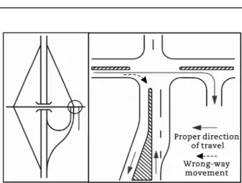
Field observations were conducted at 10 common inter-change terminals in the state of Alabama.Table 1lists all the interchange types/locations and Figs. 2e5 are schematic diagrams of the study interchange types and the possible WWD movements associated with each one. In this study, only wrong-way right-turn movements were considered.
First, we determined the distances between the side streets/ access points and the exit ramps for all 10 locations, using Google Earth software, as shown inFig. 6(a).Fig. 6(b) depicts the driving routes for each direction (northbound and southbound or eastbound and westbound). All the information regarding right-turn movements (voice commands, distances involved) from each GPS device were recorded on pre-prepared worksheets, simultaneously. Potential wrong-way left-turn movements were not tested in this study, since side streets/ access points are located next to the exit ramps and some have no median openings for left-turn movements. It is worth mentioning that, since GPS systems trigger their voice announcements solely based on device distance from the destination, the travel speed may influence the error rate as at a higher speed the driver would have less time to respond and resolve which driveway was being cued; therefore, in this study, the travel speed was set at the posted speed limit. Moreover, some navigation devices allow the road users to change settings regarding the modalities to announce a turning movement, which may also influence the error rate. To overcome this issue, all the studied GPS devices/ navigation apps do not provide users the capability of changing the settings with respect to the modalities of announcing turning movements.
Fig. 2ePossible WWD movement in diamond
interchanges.
Table 1eStudy interchange types and locations.
Interchange number Interchange type Interchange location
1 Half diamond I85/South Union St.
2 Diamond I85/Ann St.
3 Partial cloverleaf I85/Perry Hill Rd.
4 Diamond I85/West Fairview Ave.
5 Half diamond I85/Mulberry St.
6 Modified diamond I85/Eastern Blvd. 7 Modified diamond I85/Taylor Rd.
8 Diamond I85/Ryans Rd.
9 Diamond I65/West South Blvd.
10 Half diamond I85/Forest Ave.
Fig. 3ePossible WWD movement in partial cloverleaf
interchanges.
Fig. 4ePossible WWD movement in half-diamond
interchanges.
Fig. 5ePossible WWD movement in modified diamond
4.
Results and discussions
As defined above, in order to identify a“failure event”, it is necessary to determine the distance between the exit ramp and adjacent side streets/access points where the GPS devices may provide a “turn right” message before the exit ramp.
Table 2lists information about the study of interchanges and the characteristics of their nearby access points. As shown in the table, a total of 16 access points exists in the vicinity of the studied interchange areas, with distances varying between 115 and 770 feet.
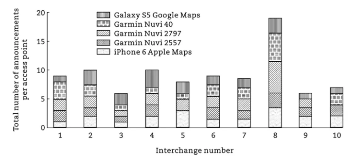
Fig. 7depicts the average number of voice announcements (i.e., turn right, go straight, and arrived) by each GPS device/ navigation app per interchange, for a total of 153 by all devices. The Garmin Nuvi 40 (GPS 4) made more frequent announcements, followed by the Garmin Nuvi 2797 (GPS 3).
Fig. 8 shows the frequency of different types of announcements by each GPS device/navigation app. GPS 3, GPS 4, and navigation app 5 provided the most voice command information regarding“turn right”,“arrived”, and
“go straight”, respectively. Notably, all of this information was delivered at different distance from the final destinations, which were located on the side street/access points, as shown inTable 3andFig. 9.
The frequency of announcements for each field test per access point by each GPS device/navigation app is shown in
Fig. 10. The results reveal that the highest number of
announcements were made at interchanges 8, 2, and 4, respectively, all of which are diamond interchanges.
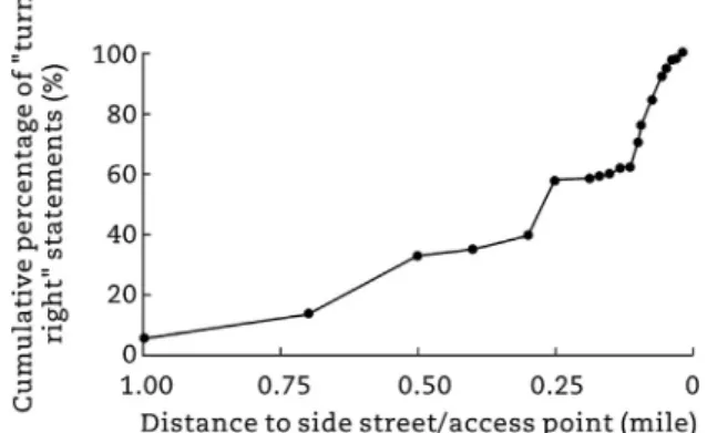
It is worth mentioning that among the three presented voice comments, only “turn right” may be misleading for drivers. FromTable 3, we see that most devices make“turn right”announcements a half mile, quarter mile, and 300e400 feet in advance of a side street or access point (in bold).
Fig. 6eSide streets/access points and exit ramps (image: Google Earth). (a) Spacing between side streets and exit ramps. (b)
Field test driving routes.
Table 2eCharacteristics of studied side streets/access points.
Interchange number
Total number of side streets/access points Distance to near exit ramp (ft) 1 1 270 2 2 160, 220 3 1 540 4 1 240 5 1 190 6 2 580, 670 7 3 250, 550, 770 8 2 260, 340 9 2 160, 225 10 1 115
Fig. 7eAverage number of announcements per
interchange by each GPS device/navigation app.
Fig. 8eNumber of announcements by each GPS device/
Therefore, the results demonstrate that when the spacing between exit ramps and nearby driveways is less than 350 feet, the chance of a misleading statement being made by GPS devices is very high; when the distance is less than one-quarter mile, the chance is high; and when the distance is more than half a mile, the chance is low (Fig. 11).
Table 4summarizes the“turn right”statement thresholds of all the GPS devices/navigation apps in this study that meet the criteria for a “failure event” scenario. As shown in the table, this threshold distance ranges from 100 feet to 200 feet, with 100 feet corresponding to GPS 3 and GPS 4, and 200 feet corresponding to GPS 2 and navigation app 5. This means that if there is any access point within 100 feet from an exit ramp, all the GPS devices/navigation apps evaluated in this study will have difficulty of guiding drivers precisely.
A comparison ofTables 2 and 4reveals which GPS devices/ navigation apps failed to audibly announce final destinations accurately in the vicinity of the study interchanges and may, therefore, lead drivers to go the wrong-way on an exit ramp (Fig. 12).
With respect to GPS 3 and GPS 4, since the spacing between all the exit ramps and nearby access points in this study were greater than 100 feet, no failed attempts were recorded. For navigation app 1, which has a threshold of 150 feet, a failed attempt was recorded at just one interchange with a spacing
Table 3eGPS/navigation apps'voice comments in advance of side streets/access points.
Distance to side street/ access point Turn right Go straight Arrived Total 1.00 mile 5 0 0 5 0.75 mile 10 0 0 10 0.50 mile 25 1 0 26 0.40 mile 3 0 0 3 0.30 mile 6 1 0 7 0.25 mile 24 0 2 26 1000 ft 0 0 1 1 900 ft 1 0 0 1 800 ft 1 0 0 1 700 ft 3 0 0 3 600 ft 0 0 0 0 0.10 mile 11 1 0 12 500 ft 7 0 1 8 400 ft 11 0 1 12 300 ft 10 0 4 14 250 ft 3 0 1 4 200 ft 4 0 5 9 150 ft 1 0 7 8 100 ft 2 0 1 3
Fig. 9eNumber of announcements by GPS devices/navigation apps vs. distance to access points.
of 115 feet. Since both GPS 2 and navigation app 5 have the same threshold of 200 feet, the total number of failed attempts were also the same, including interchanges in which the spacing between exit ramps and access points was less than 200 feet. Additionally, with respect to interchange types, interchange 10, the half-diamond interchange, accounted for the highest total number of failed attempts.
5.
Conclusions and recommendations
In this study, we evaluated a number of GPS devices and navigation apps to identify the potential to reduce wrong-way
incidents at freeway interchanges. In other words, the main contribution of this paper is to identify a serious problem which leads to severe crashes with some possible, not defin-itive, solutions. One of the challenges faced by researchers and state DOTs is to identify WWD entry points and then to implement effective safety countermeasures accordingly. Past studies have demonstrated that exit ramps are the most common WWD entry points. Today, many drivers, especially nonlocal drivers, use GPS units and navigation apps on their smartphones and other devices to navigate their routes on and off freeways. The access points located very close to exit ramps is a problem source for GPS devices in sending accurate voice guidance. The capability of these devices is not clear with respect to properly guiding drivers on turning move-ments just before exit ramp terminals at some common interchanges.
Our research results proved that the commonly used GPS devices/navigation apps we studied do not act similarly in advance of exit ramps. The findings revealed that none of the GPS devices in our study were able to guide drivers precisely when the spacing between the exit ramp and the access point is less than 100 feet. Moreover, the chance of going the wrong way is very high when the distance between an exit ramp and a nearby access point is less than 350 feet, when relying on GPS voice commands. This can increase the likelihood of drivers being involved in WWD crashes with severe injuries. The study results also revealed that, compared to stand-alone GPS devices, navigation apps had more limitations in accu-rately guiding drivers in the vicinity of interchange areas.
The results suggest that GPS companies should improve the accuracy of their mapping software and/or add new fea-tures to reduce the potential for WWD. For example, the de-vices could make an announcement“no turn right/left at next intersection”or“driving wrong-way, please turn back.”This voice command should be in consistent with road signs, such as“no turn”or“wrong-way”signs, which are placed at the intersection or along the exit ramps. To do so, it is first sug-gested to develop a new logic for determining WWD incident and then to create a computer program or app for adding to the existing navigation system. This solution could be economically and feasibly implemented and will make a game-changing impact on the current practice of engineering countermeasures for mitigating WWD activities at national and international levels.
It should be noted that although this study represents one of the early attempts to evaluate the application of GPS de-vices to reduce WWD near interchange area, conducting more research on the technological advances of these devices/apps would be desirable. Given the rapid pace of ongoing research and developments in the GPS technology, it can be expected that more accurate GPS devices could help alleviate the WWD issues in the future.
r e f e r e n c e s
American Public Transportation Association (APTA). Statistical Reports. Available at:http://www.apta.com/resources/statistics/ Pages/OtherAPTAStatistics.aspx(Accessed 1 May 2016).
Fig. 11eCumulative percentage of“turn right”statements
by GPS devices/navigation apps.
Table 4eThresholds of different GPS devices/navigation apps.
GPS device/navigation app
Threshold distance of turn right (ft) 1 150 2 200 3 100 4 100 5 200
Fig. 12eTotal number of failed attempts of GPS devices/
American Traffic Safety Services Association (ATSSA), 2014. Emerging Safety Countermeasures for Wrong-way Driving. ATSSA, Fredericksburg.
Asgari, H., Jin, X., Du, Y., 2016. Examining the impacts of telecommuting on the time-use of non-mandatory activities. In: Transportation Research Board 95th Annual Meeting, Washington, D.C.
Balali, V., Golparvar-Fard, M., 2015. Evaluation of multi-class traffic sign detection and classification methods for U.S. roadway asset inventory management. ASCE Journal of Computing in Civil Engineering, 04015022.
Baratian-Ghorghi, F., Zhou, H., 2016. Effects of photo enforcement cameras on intersection delays and driver behavior. In: Transportation Research Board 95th Annual Meeting, Washington, D.C.
Baratian-Ghorghi, F., Zhou, H., Jalayer, M., et al., 2015. Prediction of potential wrong-way entries at exit ramps of signalized partial cloverleaf interchanges. Journal of Traffic Injury Prevention 16 (6), 599e604.
Baratian-Ghorghi, F., Zhou, H., Shaw, J., 2014. Overview of wrong-way driving fatal crashes in the United States. Institute of Transportation Engineers Journal 84 (8), 41e47.
Braam, A.C., 2006. Wrong-way Crashes: Statewide Study of Wrong-way Crashes on Freeways in North Carolina. North Carolina Department of Transportation, Raleigh.
Butorac, M.A., Wen, J.C., 2004. Access Management on Crossroads in the Vicinity of Interchanges. Project 20-5 FY 2000. Transportation Research Board, Washington DC.
Cooner, S.A., Ranft, S.E., 2008. Wrong-way driving on freeways: problems, issues, and countermeasures. In: The 87th Annual Meeting of Transportation Research Board, Washington DC, 2008.
Copelan, J.E., 1989. Prevention of Wrong-way Accidents on Freeways. FHWA/CA-TE-89-2. California Department of Transportation, Sacramento.
Finley, M.D., Venglar, S.P., Iragavarapu, V., et al., 2014a. Wrong Way Driving Countermeasures. 0-6769-S. Texas A&M Transportation Institute, College Station.
Finley, M.D., Venglar, S.P., Iragavarapu, V., et al., 2014b. Assessment of the Effectiveness of Wrong Way Driving Countermeasures and Mitigation Methods. FHWA/TX-15/0-6769-1. Texas Department of Transportation, Austin.
Gong, J., Zhou, H., Gordon, C., Jalayer, M., 2012. Mobile terrestrial laser scanning for highway inventory data collection. Computing in Civil Engineering 545e552.
GPS Roads and Highways. Available at: http://www.gps.gov/ applications/roads/(Accessed 1 May 2016).
GPS Track Log. Available at:http://gpstracklog.com/(Accessed 1 May 2016).
Harris Interactive for Michelin (HIM). Survey: Most Drivers Using GPS Says It Has Led Them Astray. Available at:http://www. prnewswire.com/news-releases/survey-most-drivers-using-gps-say-it-has-led-them-astray-211818721.html (Accessed 1 May 2015).
Hoffmann-Wellenhof, B., Lichtenegger, H., Collins, J., 1994. GPS: Theory and Practice, third ed. Springer-Verlag, New York City.
Jalayer, M., Zhou, H., Gong, J., Hu, S., Grinter, M., 2014. A comprehensive assessment of highway inventory data collection methods. Journal of the Transportation Research Forum 53 (2), 73e92.
Kemel, E., 2015. Wrong-way driving crashes on French divided roads. Journal of Accident Analysis and Prevention 75, 69e76. Khalilikhah, M., Heaslip, K., 2016. Analysis of factors temporarily impacting traffic sign readability. International Journal of Transportation Science and Technology. http://dx.doi.org/ 10.1016/j.ijtst.2016.09.003.
Khalilikhah, M., Heaslip, K., Hancock, K., 2016. Traffic sign vandalism and demographics of local population: a case
study in Utah. Journal of Traffic and Transportation Engineering (English Edition) 3 (3), 192e202.
Lathrop, S.L., Dick, T.B., Nolte, K.B., 2010. Fatal wrong-way collisions on New Mexico's interstate highways, 1990e2004. Journal of Forensic Sciences 55 (2), 432e437.
Leduc, J., 2015. Wrong-way Driving Countermeasures. Available at:http://www.cga.ct.gov/2008/rpt/2008-r-0491.htm(Accessed 1 May 2015).
Mintsis, G., Basbas, S., Papaioannou, P., et al., 2004. Applications of GPS technology in the land transportation system. European Journal of Operational Research 152 (2), 399e409.
Moler, S., 2002. Stop. You are going the wrong way! Public Roads 66 (2), 24e29.
Morena, D.A., Leix, T.,J., 2012. Where these drivers went wrong. Public Roads 75 (6), 33e41.
National Highway Traffic Safety Administration (NHTSA). Fatality Analysis Reporting System (FARS) Encyclopedia. Available at:
http://www-fars.nhtsa.dot.gov/main/index.aspx (Accessed 1 May 2016).
National Transportation Safety Board (NTSB), 2012. Highway Special Investigation Report: Wrong-way Driving. NTSB/SIR-12/01. NTSB, Washington DC.
North Texas Tollway Authority (NTTA), 2009. Keeping NTTA Roadways Safe: Wrong-way Driver Task Force Staff Analysis. NTTA, Plano.
Ponnaluri, R.V., 2016. The odds of wrong-way crashes and resulting fatalities: a comprehensive analysis. Accident Analysis&Prevention 88, 105e116.
Pour-Rouholamin, M., Zhou, H., Jalayer, M., et al., 2014a. Application of access management techniques to reduce wrong-way driving near interchange areas. In: Access Management Theories and Practices, Shanghai, 2014.
Pour-Rouholamin, M., Zhou, H., Shaw, J., et al., 2014b. Overview of safety countermeasures for wrong-way driving crashes. Institute of Transportation Engineers Journal 84 (12), 31e38.
Scaramuzza, G., Cavegn, M., 2007. Wrong-way drivers: extent-interventions. In: The European Transport Conference, Noordwijkerhout, 2007.
Seitzinger, R., Fries, R., Qi, Y., et al., 2016. A driving simulator study evaluating traffic sign mounting height for preventing wrong-way driving. In: The 95th Annual Meeting of Transportation Research Board, Washington DC, 2016.
Sharifi, M.S., Shabaniverki, H., 2016. Modeling crash delays in a route choice behavior model for two way road networks. Journal of Geotechnical and Transportation Engineering 2 (1).
Sharifi, M.S., Stuart, D., Christensen, K.M., Chen, A., 2015. Traffic flow characteristics of heterogeneous pedestrian stream involving individuals with disabilities. Transportation Research Record: Journal of the Transportation Research Board 2537, 111e125.
Soltani-Sobh, A., Heaslip, K., El Khoury, J., 2015a. Estimation of road network reliability on resiliency: an uncertain based model. International Journal of Disaster Risk Reduction 14, 536e544.
Soltani-Sobh, A., Heaslip, K., Bosworth, R., Barnes, R., 2015b. Effect of improving vehicle fuel efficiency on fuel tax revenue and greenhouse gas emissions. Transportation Research Record: Journal of the Transportation Research Board 2502, 71e79.
Vicedo, P., 2006. Prevention and management of ghost drivers incidents on motorways: the French experience the contribution of ITS to immediate detection and optimum management of ghost drivers incidents. In: The 13th ITS World Congress, London, 2006.
Weih, R.C., Gilbert, M., Cross, J., et al., 2009. Accuracy assessment of recreational and mapping grade GPS receivers. Journal of the Arkansas Academy of Science 63, 163e168.
Xing, J., 2014. Characteristics of wrong-way driving on motorways in Japan. IET Intelligent Transport Systems 9 (1), 3e11.
Zhou, H., Jalayer, M., Gong, J., Hu, S., Grinter, M., 2013. Investigation of Methods and Approaches for Collecting and Recording Highway Inventory Data. FHWA-ICT-13e022. Illinois Department of Transportation, Rantoul.
Zhou, H., Pour-Rouholamin, M., 2014. Guidelines for Reducing Wrong-way Crashes on Freeways. FHWA-ICT-14-010. Illinois Department of Transportation, Rantoul.
Zhou, H., Wang, L., Gahrooei, M.R., et al., 2012a. Contributing factors to wrong-way driving crashes in Illinois. In: ITE Mid-Western District Conference and TRB 4th Urban Street Symposium, Chicago, 2012.
Zhou, H., Zhao, J., Fries, R., et al., 2012b. Investigation of Contributing Factors Regarding Wrong-way Driving Crashes on Illinois Freeways. FHWA-ICT-12-010. Illinois Department of Transportation, Rantoul.
Mohammad Jalayer, PhD,is a research asso-ciate at the Center for Advanced Infrastruc-ture and Transportation (CAIT), Rutgers University. He received a doctorate of philos-ophy in Civil Engineering-Transportation En-gineering from Auburn University. He has nine years of experience in traffic engineering and been deeply involved in research work related to traffic operations and safety, Intelligent transportation systems, and access manage-ment. He is a member of ASCE and ITE.
Huaguo Zhou, PhD, P.E., is an associate professor in the Department of Civil Engi-neering at Auburn University. He earned a doctorate of philosophy degree in civil engi-neering from the University of South Florida. He is a fellow of ITE and a licensed profes-sional engineer in Florida.
Beijia Zhang is a doctoral student in the Department of Civil Engineering at Auburn University. Her primary research interests include transportation engineering, and traffic operations and safety. She is a student member of ITE.