2019 International Conference on Information Technology, Electrical and Electronic Engineering (ITEEE 2019) ISBN: 978-1-60595-606-0
The Design and Implementation of a Geographical Information System
Applying to Orienteering Competition
Guo CHENG
*, Qi-ming XING and Qi-sheng WANG
Academy of Military Instruction, National University of Defense Technology
Changsha, 410072, Hunan Province, China
*Corresponding author
Keywords: Geographical information system, Orienteering, Data analysis.
Abstract. Recently, Orienteering has become a popular sport among civilian, and Orienteering competitions have become very popular events in China. In order to solve the problems emerging in an Orienteering competition such as cheating, injury, pertinency training and organizing burden, we develop a Geographical Information System named as Cinton. There are three parts in Cinton, i.e., Communication Server for data management, Competitor Client for competitors and Referee Client for referees. There are four key functions, i.e., anti-cheating that prevents fake finding control points, fast rescue for injury, field preparation that helps referees setting control points, and data analysis that discover valuable knowledge. By demonstrating the usage flow of each part in detail, we can see that Cinton can provide with practical help to competitors, coaches and referees in Orienteering competition.
Introduction
In the late 19th century in Sweden, Orienteering was originally a training exercise in land navigation for military officers [1]. By now, Orienteering has become a group of sports that requires navigational skills using a map and compass to navigate from point to point in diverse and usually unfamiliar terrain whilst moving at speed [2]. Among all kinds of orienteering sports, Foot Orienteering is the oldest and the most popular one that is a timed sport in which participants start at staggered intervals, are individually timed, and are expected to perform all navigation on their own feet. The control points are shown on the orienteering map and/or described with specified information such as location coordinates and marker description, and must be found in the specified order [3]. Standings are determined first by successful completion of finding all control points, then by shortest time reaching destination. In this paper we use Orienteering as the abbreviation of Foot Orienteering, because that is also what people call it nowadays.
These years, Orienteering has become very popular in China. Numbers of universities and high schools have set up some courses named like Orienteering Skills and Orienteering Rules. Many Organizations have held Orienteering activities and events now and then. Orienteering is not only a sport but also a competition now. However, there come a series of new problems in formal Orienteering competitions.
(1) Cheating Problem. Competitors are able to cheat in finding control points because the referees cannot follow every competitor from the beginning to the end.
(2) Injury and Rescure. Competitors may have security risks because the Orienteering competition field is normally open and large, and the injury situations are often appeared.
(3) Pertinency Training. Orienteering coaches cannot obtain their competitors’ competition details, therefore the training pertinency is not high after a competition.
In this paper, we develop a Geographical Information System applying to Orienteering competition that can solve the abovementioned problems. We name the system as Cinton, which is Chinese transliteration of stars connection.
Functional Design
Main Functions
According to the problems emerging in Orienteering competitions, Cinton is designed with the following four main functions.
(1) Anti-Cheating. The system can help referees monitor every competitor during the competition, and can help referees judge if control points are trule found.
(2) Fast Rescue. The system can help staff execute emergency rescue in short time, when a competitor is injured during the competition.
(3) Field Preparation. The system can help referees prepare competition field such as seting control points, making tasks, drawing maps and calculating scores.
(4) Data Analysis. The system can provide with data analysis applications which are valuable to competors, coaches, and referees.
Functional Modules
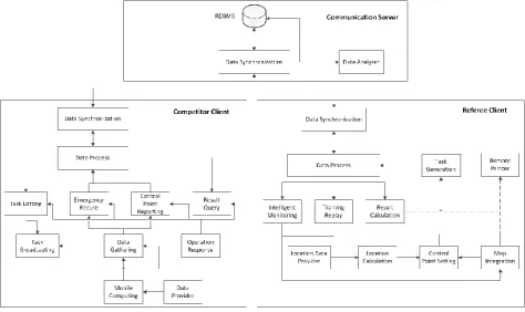
Cinton contains three parts, Communication Server (CS), Competitor Client (CC) and Referee Clients (RC).
CS manages competition data in a Relational DataBase Management System (RDMBS) [7], and provides with several data analysis applications. It is the transfer station between CS and CC.
CC is designed to prevent competitors cheating and rescue them when they are injured during the competition. Figure 1 shows the functional modules and the data flow in CC. The usage of each module explain as follow.
(1) Data Process Module is to store, manage and process data collected from competitors; (2) Task Lotting Module is to lot a train task from Data Process Module;
(3) Task Broadcasting Module is to request task data from Task Lotting Module, and present the information of a task via text and/or audio after data parsing;
(4) Data Provider Module is to sample data periodically including GPS data and time data;
(5) Mobile Computing Module is to calculate the location data from Data Provider Module such as geographic coordinates, planimetric rectangular coordinates, direction, speed;
(6) Data Gathering Module is to collect data from Mobile Computing Module periodically; (7) Control Point Reporting Module is to help competitors report the location and time which are received from Data Provider Module, when finding a Control Point;
(8) Emergency Rescue Module is to report the location received from Data Provider Module, when a competitor is injured or lost during the training;
(9) Result Query Module is to request result data from Data Process Module and present the result after data parsing;
(10) Operation Response Module is to receive and response the operations from students during training, and also control the data flow among all modules;
(11) Data Synchronization Module is to communicate with Data Center Server and make sure the data is synchronized to RDBMS.
RC is designed to help referees reduce the workload, increase the level of Orienteering competitions. Figure 1 shows the functional modules and the data flow in RC. The usage of each module explain as follow.
(1) Map Integration Module is to compose, process and store maps;
(3) Task Generation Module is to generate a task by choose origin, destination, and a series of control points with the data support from Control Point Setting Module and Map Integration Module;
(4) Location Data Provider Module is to export location data periodically;
(5) Location Calculation Module is to calculate the precise coordinates of each control point from the location data support from Location Data Provider Module;
(6) Data Process Module is to store, manage and process all kinds of data sampled from referees during the whole competition;
(7) Intelligent Monitoring Module is to parse the report data from Data Processing Module into time and location information, and thus to monitor competitors whether find correct control points automatically and intelligently, or cheating;
(8) Training Replay Module is to parse the training data from Data Processing Module into training course information such as track, speed and direction, and thus to replay if requested;
(9) Result Calculation Module is to parse the result data from Data Processing Module into training result, and thus to calculate score;
[image:3.595.60.535.303.585.2](10) Data Synchronization Module is to communicate with Data Center Server and make sure the data is synchronized to RDBMS.
Figure 1. Functional modules in competitor client and referee client.
Data Analysis Applications
In this paper, we investigate three data analysis applications to acquire practical knowledge that can help competitors, coaches and referees with respect to Orienteering.
The first application aims at the relationship between control points and their terrain environment, i.e., where a control point is at. The difficult level of each control point can be judged via computing the finding rate of each control point. And then the difficult level of every kind of terrain environment can be acquired. This kind of knowledge is helpful for referees to make plans before Orienteering competition starts.
what the competitor is good at and bad at. This kind of knowledge is helpful for competitors to improve their Orienteering skill.
The last application aims at the comparison of data of all competitors in the same one competition. Different competitors have the same ground but the different result. The features of competitors can be found via the data comparison [8], which is helpful for coaches to improve the targeted training; the common problems can be found via the data statistics, which is helpful for referees to modify the competition plan.
Implementation and Usage Flow
Implementation Conditions
Table 1 shows the details of implementation condition for Cinton. CS is a program running on a workstation with Ubuntu Operating System. CC is an Android application running on a tablet; while RC is an Android application running on a mobile phone. By now we have only developed the Android version because mobile phones of Android OS is much more widespread than iPhones. In the further, we will develop the iOS version for iPhone users.
Table 1. Details of implementation condition.
Communication Server Competitor Client Referee Client
Running
Operating System Ubuntu 11.2 Android 6.0 Android 6.0
Programming
Operating System Ubuntu 11.2 Windows 7 Windows 7
Programming Language Java 7.0 Java 7.0 Java 7.0
Test Hardware Workstation Huawei Tablet Huawei Mobile Phone
Usage Flow
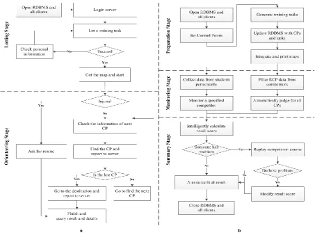
Figure 2.a shows that there are mainly two stages in the usage flow of CC. The lotting stage is before a competition starts. The key step is to draw a task with the help of Task Lotting Module. The lotting is random and all of the tasks should have comparable difficulties. The orienteering stage is a periodic process. Competitors will find each Control Point and report immediately until the last Control Point has been found. When reaching the destination, the last report means the competition is finished and the result will be ready to check in a short time.
Figure 2.b shows that there are mainly three stages in the usage flow of RC.The preparation stage is before the competition. The key step is to set lots of Control Points with the help of Map Integration Module. Another key step is to generate a series of tasks intelligently and automatically with the help of Task Generation Module. The monitoring stage is in the competition. Referees can monitor a specified competitor manually, while the client could judge all the students automatically, which means the cheating will be prevented thoroughly. The summary stage is after the class. The key step is to replay the training course if a student has questioned the result. This step could not only solve the question but also help a student find where the problem is and how to improve effectively.
Summary
Acknowledgments
[image:5.595.71.525.136.474.2]The study of this paper is supported by Educational Reform Program of National University of Defense Technology (No.XJK014CGF001) and the fund of Brilliant Fellow of Academy of Military Instruction.
Figure 2. Usage flow chart of Competitor Client.
References
[1] F. Zhang, Y. Zhu, and Y. F. Wang, Research on the Construction of the Military Colleges’ Orienteering Curriculum. Journal of Military Physical Education and Sports. 34, 3, 2015, pp. 117-119.
[2] "Orienteering". Wikipedia. DOI= https://en.wikipedia.org/wiki/Orienteering
[3] Foot orienteering. Wikipedia. DOI= https://en.wikipedia.org/wiki/Foot_orienteering
[4] H. Xu, Research on the Current Situation and Strategy of Orienteering in ZheJiang Province. Journal of Beijing Sport University. 28, 10, 2005, pp. 1409-1410.
[5] D. Brosset, C. Claramunt, E. Saux, Way finding in natural and urban environments: a comparative study. Cartographica: The International Journal for Geographic Information and Geovisualization, 43, 1, 2008, pp. 21-30.
[6] L. Zentai, New technologies in making orienteering maps. International cartographic conference, 2007, pp. 1-10.
[7] T. Bakuya, M. Matsui, Relational database management system. U.S. Patent 5, 1997, pp. 680,614.