Munich Personal RePEc Archive
Natural hazards and disaster
management in Pakistan
Khan, Himayatullah and Khan, Abuturab
12 October 2008
Online at
https://mpra.ub.uni-muenchen.de/11052/
Natural hazards and disaster management in Pakistan
Himayatullah Khan
Professor, Department of Development Studies COMSATS Institute of Information Technology, Abbottabad
and
Institute of Development Studies NWFP Agricultural University, Peshawar
Email: himmy@ciit.net.pk
Abuturab Khan
Assistant Professor, Department of Development Studies COMSATS Institute of Information Technology
Abbottabad
Email: abuturab@ciit.net.pk
Abstract: The present study explains the various concepts used in disaster management. The concepts explained include: Disaster, Hazard, Vulnerability, Capacity, Risk and Disaster Management Cycle. In addition to the terminologies, the study also seeks to explain various types of disasters. It also gives a detail of various disasters occurred in Pakistan as well their management and mitigation strategies. The paper also discusses disaster management policy at national level as well as disaster management and national plans in Pakistan.
Keywords: Natural Hazards, Disaster Management, Pakistan
JEL classification: I 30, I 00, A10
I. Introduction
Disaster is a sudden adverse or unfortunate extreme event which causes great damage to human beings as well as plants and animals. Disasters occur rapidly, instantaneously and indiscriminately. These extreme events either natural or man-induced exceed the tolerable magnitude within or beyond certain time limits, make adjustment difficult, result in catastrophic losses of property and income and life is paralyzed. These events which occur aggravate natural environmental processes to cause disasters to human society such as sudden tectonic movements leading to earthquake and volcanic eruptions, continued dry conditions leading to prolonged droughts, floods, atmospheric disturbances, collision of celestial bodies, etc. (Joshi, 2008).
natural hazards. The international dimension of disasters was realized and a protocol sought to be established so that when it comes to suffering of humanity, help from the International community flow in right earnest.
Almost everyday, newspapers, radio and television channels carry reports on disaster striking several parts of the world. But what is a disaster? The term disaster owes its origin to the French word “Desastre” which is a combination of two words ‘des’ meaning bad and ‘aster’ meaning star. Thus the term refers to ‘Bad or Evil star’. The United Nations defined Disasters as ‘A serious disruption of the functioning of a community or a society causing widespread human, material, economic and environmental losses which exceed the ability of the affected community / society to cope using its own resources’ (UNDP, nd).
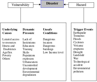
[image:3.612.160.485.422.697.2]A disaster is a result from the combination of hazard, vulnerability and insufficient capacity or measures to reduce the potential chances of risk. A disaster happens when a hazard impacts on the vulnerable population and causes damage, casualties and disruption. Figure 1 gives a better illustration of what a disaster is. Any hazard – flood, earthquake or cyclone which is a triggering event along with greater vulnerability (inadequate access to resources, sick and old people, lack of awareness etc) would lead to disaster causing greater loss to life and property. For example; an earthquake in an uninhabited desert cannot be considered a disaster, no matter how strong the intensities produced. An earthquake is disastrous only when it affects people, their properties and activities. Thus, disaster occurs only when hazards and vulnerability meet. But it is also to be noted that with greater capacity of the individual/community and environment to face these disasters, the impact of a hazard reduces. Therefore, we need to understand the three major components namely hazard, vulnerability and capacity with suitable examples to have a basic understanding of disaster management.
Figure 1: What is a disaster?
Vulnerability Disaster Hazard
Underlying Dynamic Unsafe Causes Pressure Conditions
Limited access Lack of: Dangerous to resources Institutions location Illness and Education Dangerous Disabilities Training buildings
Age/Sex Skills Low Income level Poverty Population
Others explosion Urbanization Uncontrolled development Environmental degradation
Trigger Events
Earthquake Tsunamis Floods Cyclones Volcanic eruptions Drought Landslide War
1.1. What is a Hazard? How is it classified?
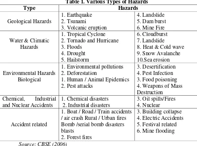
[image:4.612.106.506.279.575.2]Hazard may be defined as “a dangerous condition or event, that threat or have the potential for causing injury to life or damage to property or the environment.” Hazards can be grouped into two broad categories namely natural and manmade. 1. Natural hazards are hazards which are caused because of natural phenomena (hazards with meteorological, geological or even biological origin). Examples of natural hazards are cyclones, tsunamis, earthquake and volcanic eruptions which are exclusively of natural origin. Landslides, floods, drought, fires are socio-natural hazards since their causes are both natural and man made. For example flooding may be caused because of heavy rains, landslide or blocking of drains with human waste. 2. Manmade hazards are hazards which are due to human negligence. Manmade hazards are associated with industries or energy generation facilities and include explosions, leakage of toxic waste, pollution, dam failure, wars or civil strife, etc. The list of hazards is very long. Many occur frequently while others take place occasionally. However, on the basis of their genesis, they can be categorized as follows:
Table 1. Various Types of Hazards
Type Hazards
Geological Hazards
1. Earthquake 2. Tsunami
3. Volcanic eruption
4. Landslide 5. Dam burst 6. Mine Fire
Water & Climatic Hazards
1. Tropical Cyclone 2. Tornado and Hurricane 3. Floods
4. Drought 5. Hailstorm
6. Cloudburst 7. Landslide
8. Heat & Cold wave 9. Snow Avalanche 10.Sea erosion
Environmental Hazards Biological
1. Environmental pollutions 2. Deforestation
1. Human / Animal Epidemics 2. Pest attacks
3. Desertification 4. Pest Infection 3. Food poisoning 4. Weapons of Mass Destruction
Chemical, Industrial and Nuclear Accidents
1. Chemical disasters 2. Industrial disasters
3. Oil spills/Fires 4. Nuclear
Accident related
1. Boat / Road / Train accidents / air crash Rural / Urban fires Bomb /serial bomb disasters blasts
2. Forest fires
3. Building collapse 4. Electric Accidents 5. Festival related 6. Mine flooding
Source: CBSE (2006)
1.2. What is Vulnerability?
Vulnerability may be defined as “The extent to which a community, structure, services or geographic area is likely to be damaged or disrupted by the impact of particular hazard, on account of their nature, construction and proximity to hazardous terrains or a disaster prone area.”
capability of building and structures to resist the forces acting upon them during a hazard event.
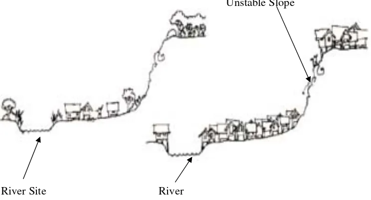
Figure 2 shows the settlements which are located in hazardous slopes. Many landslide and flooding disasters are linked to what you see in the Figure 2. Unchecked growth of settlements in unsafe areas exposes the people to the hazard. In case of an earthquake or landslide the ground may fail and the houses on the top may topple or slide and affect the settlements at the lower level even if they are designed well for earthquake forces.
Unstable Slope
[image:5.612.121.493.176.377.2]River Site River
Figure 2: Site after pressures from population growth and urbanization
1.3. Socio-economic Vulnerability:
The degree to which a population is affected by a hazard will not merely lie in the physical components of vulnerability but also on the socioeconomic conditions. The socio-economic conditions of the people also determine the intensity of the impact. For example, people who are poor and living in the sea coast don’t have the money to construct strong concrete houses. They are generally at risk and loose their shelters when ever there is strong wind or cyclone. Because of their poverty they too are not able to rebuild their houses.
1.4. What is Capacity?
Capacity can be defined as “resources, means and strengths which exist in households and communities and which enable them to cope with, withstand, prepare for, prevent, mitigate or quickly recover from a disaster”. People’s capacity can also be taken into account. Capacities could be classified into physical and socio-economic capacities. Physical Capacity: People whose houses have been destroyed by the cyclone or crops have been destroyed by the flood can salvage things from their homes and from their farms. Some family members have skills, which enable them to find employment if they migrate, either temporarily or permanently.
Hazards are always prevalent, but the hazard becomes a disaster only when the frequency or likelihood of a hazard and the vulnerability of the community increases the risk of being severely affected.
1.5. What is Risk?
Risk is a “measure of the expected losses due to a hazard event occurring in a given area over a specific time period. Risk is a function of the probability of particular hazardous event and the losses it would cause.” The level of risk depends upon:
• Nature of the hazard
• Vulnerability of the elements which are affected
• Economic value of those elements
A community/locality is said to be at ‘risk’ when it is exposed to hazards and is likely to be adversely affected by its impact. Whenever we discuss ‘disaster management’ it is basically ‘disaster risk management’. Disaster risk management includes all measures which reduce disaster related losses of life, property or assets by either reducing the hazard or vulnerability of the elements at risk.
1.6. Disaster Management Cycle
[image:6.612.121.492.366.682.2]Disaster Risk Management includes sum total of all activities, programmes and measures which can be taken up before, during and after a disaster with the purpose to avoid a disaster, reduce its impact or recover from its losses. The three key stages of activities that are taken up within disaster risk management are as follows (See Figure 3):
1. Before a disaster (pre-disaster). Pre-disaster activities those which are taken to reduce human and property losses caused by a potential hazard. For example, carrying out awareness campaigns, strengthening the existing weak structures, preparation of the disaster management plans at household and community level, etc. Such risk reduction measures taken under this stage are termed as mitigation and preparedness activities.
2. During a disaster (disaster occurrence). These include initiatives taken to ensure that the needs and provisions of victims are met and suffering is minimized. Activities taken under this stage are called emergency response activities.
3. After a disaster (post-disaster). There are initiatives taken in response to a disaster with a purpose to achieve early recovery and rehabilitation of affected communities, immediately after a disaster strikes. These are called as response and recovery activities.
The Disaster risk management cycle diagram (DRMC) highlights the range of initiatives which normally occur during both the Emergency response and Recovery stages of a disaster. Some of these cut across both stages (such things as coordination and the provision of ongoing assistance); whilst other activities are unique to each stage (e.g. Early Warning and Evacuation during Emergency Response; and Reconstruction and Economic and Social Recovery as part of Recovery). The DRMC also highlights the role of the media, where there is a strong relationship between this and funding opportunities. This diagram works best for relatively sudden-onset disasters, such as floods, earthquakes, bushfires, tsunamis, cyclones etc, but is less reflective of slow-onset disasters, such as drought, where there is no obviously recognizable single event which triggers the movement into the Emergency Response stage.
According to Warfield (2008) Disaster management aims to reduce, or avoid the potential losses from hazards, assure prompt and appropriate assistance to victims of disaster, and achieve rapid and effective recovery. The disaster management cycle illustrates the ongoing process by which governments, businesses, and civil society plan for and reduce the impact of disasters, react during and immediately following a disaster, and take steps to recover after a disaster has occurred. Appropriate actions at all points in the cycle lead to greater preparedness, better warnings, reduced vulnerability or the prevention of disasters during the next iteration of the cycle. The complete disaster management cycle includes the shaping of public policies and plans that either modify the causes of disasters or mitigate their effects on people, property, and infrastructure.
The mitigation and preparedness phases occur as disaster management improvements are made in anticipation of a disaster event. Developmental considerations play a key role in contributing to the mitigation and preparation of a community to effectively confront a disaster. As a disaster occurs, disaster management actors, in particular humanitarian organizations become involved in the immediate response and long-term recovery phases. The four disaster management phases illustrated here do not always, or even generally, occur in isolation or in this precise order. Often phases of the cycle overlap and the length of each phase greatly depends on the severity of the disaster. o Mitigation - Minimizing the effects of disaster. Examples: building codes and zoning; vulnerability analyses; public education.
o Preparedness - Planning how to respond. Examples: preparedness plans; emergency exercises/training; warning systems.
o Recovery - Returning the community to normal. Examples: temporary housing; grants; medical care.
To analyze the scope of disaster management in the revised context, let us study the cycle of the phenomenon (Figure 4).
[image:8.612.164.476.116.328.2]
Fig: 4 Disaster Management Cycle
Disasters are as old as human history but the dramatic increase and the damage caused by them in the recent past have become a cause of national and international concern. Over the past decade, the number of natural and manmade disasters has climbed inexorably. From 1994 to 1998, reported disasters average was 428 per year but from 1999 to 2003, this figure went up to an average of 707 disaster events per year showing an increase of about 60 per cent over the previous years. The biggest rise was in countries of low human development, which suffered an increase of 142 per cent.
Figure 5 shows the deadliest disasters of the decade (1992 – 2001).
.
45%
16% 14%
12% 10%
3%
Drought/Famine Floods Technological Earthquake Windstorm Miscellaneous R
I
S
K
M
A
N
A
G
E
M
E
N
T
[image:8.612.148.471.464.683.2]Drought and famine have proved to be the deadliest disasters globally (45%), followed by floods (16%), technological disaster (14%), earthquake (12%), windstorm (10%), extreme temperature and others (3%). Global economic loss related to disaster events average around US $880 billion per year (CBSE, 2006).
II. Pakistani Scenario1
Like other South Asian countries, Pakistan continues to suffer from a plethora of natural and human induced hazards that threaten to affect the lives and livelihood of its citizens – natural disasters including floods, earthquakes, landslides, cyclones, and drought to human induced disasters such as fires, civil unrest and terrorism, refugees and internally displaced people, health epidemics, transport accidents, industrial accidents and war. The human impact of natural disasters in Pakistan can be judged by the fact that 6,037 people were killed and 8,989,631 affected in the period from 1993 to 2002 (World Disasters Report 2003).
2.1. Earthquake
Pakistan lies in a seismic belt and therefore suffers from frequent earthquakes of small magnitudes. Earthquakes normally occur along the Himalayas, Karakorums and partly Hindu Kush ranges in the north, Koh-e-Sulaiman range in the west with Chaman fault line along Quetta, and Mekran fault line along the sea coast. Their occurrence is normally associated with the dynamics associated with the Indian plate exerting continuous pressure on the Eurasian land mass. In 1935 an earthquake of above 6.5 on Richter Scale intensity rocked Quetta leaving 35,000 dead. From 1974 to 1990, approximately 5669 people were killed due to earthquakes in the Northern Areas (NA), NWFP and Balochistan. There was a significant earthquake that occurred in February 2004, in NWFP resulting in 24 deaths and over 129,000 people were affected. Pakistan is known to be vulnerable to a wide array of natural and man instigated disasters, but October 2005 earthquake was the worst natural disaster that the nation has experienced in the recent history. Post October 2005 earthquake studies confirm country’s continued vulnerability to the hazard in these regions.
2.2. Tsunami
Past history also shows vulnerability to tsunamiand other sea based hazards along its long coastline. In fact, in 1935 an earthquake of 8.5 on Richter Scale triggered a tsunami along the Baluchistan coastline, killing nearly 4000 along the fishing town of Pasni. Karachi and Gwador were also threatened. The Indian peninsula, luckily shielded Pakistan’s coastline from the disastrous impact of 2004 tsunami.
2.3. Cyclones
Talking of sea borne hazards, the 960 kms costal belt, particularly along Sindh, is occasionally battered by cyclones. In 1999 a cyclone ravaged large tracts in coastal districts of Thatta and Badin causing widespread loss to life and property. These coastal areas are also inundated by torrential rains, as in 2003 with a similar impact. Although not a frequent phenomenon, cyclones can cause large-scale damage to the coastal areas of Sindh and Balochistan. The cyclone of 1999 in Thatta and Badin districts wiped out 73 settlements, and resulted in 168 lives lost, nearly 0.6 million people affected and killing of 11,000 cattle. It destroyed 1,800 small and big boats and partially damaged 642 boats, causing a loss of Rs. 380 million. The losses to
infrastructure were estimated at Rs.750 million. The period between 1971 and 2001 recorded 14 cyclones. The coastal areas of Sindh are most vulnerable and exposed to cyclones.
2.4. Floods
The alluvial plains of the Indus river system have been traditionally vulnerable to recurring floods. The last floods causing considerable damage to life and property occurred in 1992. However, this is one hazard against which an effective protection network of dykes and flood water regulatory infrastructure has been built over the years. Pakistan is one of the five South Asian countries with the highest annual average number of people physically exposed to floods, which occur normally due to storm systems that originate from Bay of Bengal during the monsoon from July to September. The storms originating in Bay of Bengal passing over lower Central India and Rajputana enter Pakistan and continue towards North into Kashmir. The mountain ranges in the extreme north of Pakistan provide a perennial source of inflow into the rivers. Floods particularly hit Punjab and Sindh while hill torrents tend to affect the hilly areas of North Western Frontier Province, Balochistan and the northern federally administered areas. Flood events of 1950, 1992 and 1998 caused many deaths and huge losses to the national economy. According to official sources, floods in Pakistan during the decade 1991 to 2001 caused an estimated damage of over Pak Rs. 78,000 million to property. Table 2 portrays major flood events in Pakistan.
[image:10.612.168.435.409.682.2]Concomitant with the riverine floods during the summer monsoons, flash floods and land slide hazardsoccur frequently in the mountainous north along watersheds. Flash floods also occur in upper plains adjacent to river catchment areas. Rising incidence of loss of life and property indicates relative un-preparedness to such hazards.
Table 2: Major Flood Events in Pakistan
Year Lives Lost Villages Affected
1950 2910 10000
1955 679 6945
1956 160 11609
1973 474 9719 1975 126 8628 1976 425 9150 1978 393 9199
1988 508 1000
1992 1008 13208
1995 591 6852 1998 47 161
2001 201 0.4 million*
2003 230 1.266 million*
2.5. Drought
Drought has become an intermittent problem of the country. In recent years drought is reported to have brought extensive damages to Balochistan, Sindh and Southern Punjab where average rainfall is as low as 200-250 mm. Severe drought periods in 2000 and 2002 affected livelihoods, resulted in human deaths, pushed tens of thousands people to migrate, and killed large numbers of cattle. This drought led to 120 deaths and affected 2,200,000 people. The main arid rangelands are Thar, Cholistan, Dera Ghazi Khan, Tharparkar, Kohistan, and western Balochistan. Except Balochistan, all of these areas are within the range of monsoon rainfall, which, however, is erratic and scattered. Hence, 2 to 3 years in every 10 years in these areas are drought years.
Fewer occurrences of floods seem to be linked, owing to changing regional weather patterns, with prolonged incidence of droughts in the poverty ridden arid regions of the country.
The drought phenomenon was most pronounced during 2000-2003 period when it spread across 68 districts in the four provinces. That was the period when an institutional capacity to deal with hazard was created in the country. However, the drought hazard has taken a massive toll in environment and economic loss dimensions2.
2.6. Viral Diseases
One of the negative fallouts of the globalization phenomenon means vulnerability to a vast array of viral diseases, be it bird avian flu or the dengue virus. We are presently witnessing a widespread occurrence of the latter in the country and efforts to combat the disease are included in this evaluation. Incidence of dengue fever has affected about 4100, mostly in Karachi but also in other parts of the country including some cities of Punjab. About 46 persons have died so far. While an effective media campaign has generated awareness against the disease but vector eradication efforts have been inconclusive. It poses a severe public safety hazard.
Gaining much prominence are hazards associated with the rising incidence of fire, traffic and industrial accidents. These are those hazards which cause the maximum harm and against which we have shown little corrective resolve be it in terms of social awareness, legislative support or quality functional practices. Emergency services require much reorganization and capacity building.
Pakistan is also a nuclear capable country though it claims enforcement of satisfactory nuclear safety standards. It is our basic fault lines or dynamic pressure exerted by socio-economic poverty, rising population stress on finite resources, poor state of environmental health, unplanned development multiplying hazard impact and a poor awareness of hazard prevention that enhance our vulnerabilities. The chart produced below profiles losses to natural hazards3.
2 Pakistan Metrological Department and Norstar Norway, Seismic hazard analysis for the Cities of Islamabad and Rawalpindi, pp16-18, 2006.
3 National Disaster Management Authority, Draft National Disaster Management Framework, pp
Table 3: Major Natural Disasters in Pakistan (Loss in terms of human lives)
Disaster Date Died Affected Damage $
(000)
Earthquake May 31, 1935 35,000 _ _ Earthquake
(Tsunami)
Nov. 27, 1945 4,000 _ _
Earthquake Dec. 28, 1974 4,700 _ 3,255 Earthquake Jan. 31, 1991
Earthquake Oct. 8, 2005 73,338 2,869, 142 5,000,000
Total 117,038
Flood 1950 2,900
Flood August 1976 5,556,000 505,000
Flood July 1978 2,246,000
Flood July 1992 1334 12,324,024 1,000,000
Flood 1994 92,000
Flood August 1996 1,300,000 _
Flood June 1997 848 _ _
Flood March 1998 1,000 _ _
Flood February 2005 7,000,450
Flood July 2001 246,000
Flood July 2003 1,266,223
Total 6082
Drought 2000-02 2,200,000 247,000
Windstorm 15 Dec 1965 10,000 Windstorm 14 Nov 1993 609
Grand Total 133,728
Source: EM – DAT Emergency database. http//www.em.net/disasters/pr
III. Disaster Management Policy at National Level4
Disaster management policy in Pakistan exhibits following features:
1) Disaster management in Pakistan basically revolves around flood disasters with a primary focus on rescue and relief. After each disaster episode the government incurs considerable expenditure directed at rescue, relief and rehabilitation.
2) Applied disaster management policy sometimes carries strategic biases that are aimed at protecting locations and infrastructure of greater economic, political and strategic significance at the cost of areas and communities with lesser influence and importance.
3) Within disaster management bodies in Pakistan, there is a dearth of knowledge and information about hazard identification, risk assessment & management, and linkages between livelihoods and disaster preparedness. Disaster management policy responses are not generally influenced by methods and tools for cost-effective and sustainable interventions.
4) There are no long-term, inclusive and coherent institutional arrangements to address disaster issues with a long-term vision. For instance, the Emergency Relief Cell is mandated to deal only with post-disaster scenarios.
5) Disasters are viewed in isolation from the processes of mainstream development and poverty alleviation planning. Some of the large-scale development projects are bringing new forms of disaster and adding to the vulnerability of at-risk communities. The Left Bank Outfall Drainage (LBOD) project and link canals are significant examples in Pakistan.
6) Disaster management, development planning and environmental management institutions operate in isolation and integrated planning between these sectors is almost lacking.
7) Absence of a central authority for integrated disaster management and lack of coordination within and between disaster related organizations is responsible for effective and efficient disaster management in the country.
8) State-level disaster preparedness and mitigation measures are heavily tilted towards structural aspects and undermine non-structural elements such as the knowledge and capacities of local people, and the related livelihood protection issues.
9) Disaster and relief departments and organizations largely remain under-resourced, untrained, and not given required importance within administrative hierarchy. A dedicated fund for disaster management at the federal level has never been a part of the overall development planning. The officials of two important organizations engaged in disaster management e.g. Emergency Relief Cell and Federal Flood Commission are not provided with adequate training. A great deal of uncertainty prevails among government employees about their stay in any disaster related organization / department, which contributes towards working with less interest and efficiency.
10) Given the frequent incidence of floods during monsoon season the government has taken adequate measures for flood control and management down to district level. The Pakistan Army plays a significant role in flood management by providing search and rescue services and emergency relief in affected areas. Flood Commission commences flood fighting plans every year in April and monitors the discharge of water at strategically important barrages and dams, and maintains a regular interaction with all provincial governments in pre, during and post flood situations. The district, provincial and federal governments prepare flood fighting plans annually and ensure timely dissemination of early warning through indigenous and modern modes of communication.
IV. Disaster Management and National Plans 4.1. National Five years Plans (1955 – 2003)
The Five Years Plans, since 1957, when the National Economic Council (NEC) approved the final version of the First Five-Year plan, the development paradigm in Pakistan has remained oblivious of the preparedness and management of natural calamities. The plans, however, identified the mismanagement and scarcity of water resources, poor health infrastructure, and flood threats at few stages of the planning and implementation during the last three decades. But the proposed strategies and solutions were either relief-driven or event-based without having an integrated disaster management plan.
production, transport etc. For the then East Pakistan, the major purpose to be served through the first plan was to protect large areas from the saline waters of the tides and to improve waterways for inland water transport.
Similarly, the Second and Third Five-Year Plans also follow the objectives set in the First Plan and tend to adopt identical strategies to achieve overall development objectives.
4.3. Fourth Five-Year Plan (1970-75): However, after ten years, the Fourth Five-Year Plan included flood control program for the then East Pakistan and improvement of environment in big cities. Specific targets of the Plan were:
1) To undertake a major flood control program in East Pakistan outside the Fourth Plan
2) To protect the entire population from malaria and small-pox and bring about a major improvement in curative health facilities
3) To launch an Urban Works Program (UWP) to improve the environmental conditions in big cities and to cater to the community needs of the neglected areas. The physical planning and housing component of the Plan recognizes that research in environmental sanitation including air and water pollution needs to be undertaken and results enforced through appropriate standards and legislation.
4.4. Fifth Five-Year Plan (1979-83): The Fifth Plan did not take up the issue of disaster management at any level and the development progress on other fronts also remained disappointing. The on-farm water management program was started during the fifth plan period to reduce the watercourse losses. The Sixth Five-Year Plan (1983-88) identifies that the Fifth Plan period was disappointing, as there was no sufficient long-term investment either in physical infrastructure or in human resource development. This trend created shortages of energy, telephones, water and other infrastructure and resulted in a very low level of educational literacy and poor health facilities.
4.5. The Sixth Five-Year (1983-88): The Plan appears to achieve physical targets in the area of agriculture development. The proposed targets were:
1) Installation of 4312 of fresh and saline ground water tube wells.
2) Replacement of 810 tube wells and construction of 11446 miles of surface and tile drains.
3) The protection of 5.3 million acres including a disaster area of 2.8 million acres.
4) Continuation of the On-Farm Water management program to reduce the watercourse losses.
4.6. Eighth Five-Year Plan (1 993-98): The Plan, which ended up in achieving far less than proposed development targets, dealt with the issues of sustainable environment and management of water resources.
Efforts were made for improving environmental legislation and enforcement of National Environmental Quality Standards (NEQS); initiating Environmental Impact Assessment (EIA) procedures for public and private investments, and incorporating more environment-related investments in all development expenditures.
The Water Resources Development component of the Plan included a specific objective of protecting land and infrastructure from water-logging, salinity, and floods. The strategies adopted for achieving the objective were neither comprehensive nor integrated and water-logging, salinity, and floods, thus, continued to affect the poor and vulnerable sections of the society.
it incorporates environmental issue in a more harmonized manner as compared to the previous efforts at State level.
Based on the performance indicators, gaps and weaknesses of the Eighth Five-Year Plan, following are the specific objectives for water sector development during the Ninth Five-Year Plan:
i. To make more effective use of the surface and ground water. ii. To achieve equitable and assured distribution of water.
iii. To store and use river water flood surpluses through storage /carry-over dams. iv. To reduce the extent of waterlogged lands.
v. To carry out water-related research studies.
vi. To utilize flood flows including harnessing of hill torrents for augmenting water availability for irrigation.
vii. To augment investments in flood control management, including flood warning and forecasting systems.
4.7. Ten-Year Perspective Development Plan (2001-2011): By adopting strategies to reach the Millennium Development Goals (MDGs), the Ten-Year Perspective Development Plan was launched into operation on 1st July, 2001. Its total size has been fixed at Rs. 11 ,287 billion in current prices out of which Rs.8,747 billion have been envisaged as the investment of private sector and Rs.2,540 billion as Public Sector Development Program (PSDP).
4.7.1. Water Resources Development: The Plan recognizes the severity of drought in Sindh and Balochistan and the subsequent shortage of water that has aggravated the ongoing water crises. The major goal of policy formulation and sectoral planning in water resources sector during the Ten-Year Perspective Development Plan is to uplift the agro based economy on the national level by maximizing crop production. This will be achieved through progressively increasing surface water supplies using the latest technologies available and protecting land and infrastructure from water logging, salinity, floods and soil erosion.
The strategy to achieve these goals comprises:
1. Augmentation and conservation measures to overcome the scarcity of water 2. Drainage and reclamation program to protect the disastrous area
3. Flood Control and Protection
4. Rehabilitation of irrigation system of Punjab and Sindh and modernization of barrages in Punjab
The Plan gives high priority to the construction of medium and large dams and canals to meet water requirements in the future. The total outlay for the Federal Ten-Year Development Plan for Water Sector amounts to Rs.418 billion out of which Rs.63 billion has been proposed for the Three-Year Program (2002-05).
In addition, small irrigation schemes will be started, construction of 303 spurs and 1101 kilometers of flood embankments and improvement of flood warning systems will be carried out. During the three-year program (2002-05), 240 and 68 kilometers of flood embankments will be constructed to safeguard life and property.
V. Conclusions
rise was in countries of low human development, which suffered an increase of 142 per cent.
Pakistan continues to suffer from a plethora of natural and human induced hazards that threaten to affect the lives and livelihood of its citizens. The human impact of natural disasters in Pakistan can be judged by the fact that 6,037 people were killed and 8,989,631 affected in the period from 1993 to 2002. More than 80,000 people died and 3.5 million lost homes in the earthquake in 8th October 2005 earthquake. In addition to earthquakes, other natural hazards that occurred in Pakistan include Tsunami, cyclones, floods, drought, viral diseases, etc.
Disaster management in Pakistan basically revolves around flood disasters with a primary focus on rescue and relief. After each disaster episode the government incurs considerable expenditure directed at rescue, relief and rehabilitation. Within disaster management bodies in Pakistan, there is a dearth of knowledge and information about hazard identification, risk assessment and management, and linkages between livelihoods and disaster preparedness. Disaster management policy responses are not generally influenced by methods and tools for cost-effective and sustainable interventions.
There are no long-term, inclusive and coherent institutional arrangements to address disaster issues with a long-term vision. Disasters are viewed in isolation from the processes of mainstream development and poverty alleviation planning. For example, disaster management, development planning and environmental management institutions operate in isolation and integrated planning between these sectors is almost lacking.
Absence of a central authority for integrated disaster management and lack of coordination within and between disaster related organizations is responsible for effective and efficient disaster management in the country. State-level disaster preparedness and mitigation measures are heavily tilted towards structural aspects and undermine non-structural elements such as the knowledge and capacities of local people, and the related livelihood protection issues.
Given the frequent incidence of floods during monsoon season the government has taken adequate measures for flood control and management down to district level. The Pakistan Army plays a significant role in flood management by providing search and rescue services and emergency relief in affected areas. Flood Commission commences flood fighting plans every year in April and monitors the discharge of water at strategically important barrages and dams, and maintains a regular interaction with all provincial governments in pre, during and post flood situations. The district, provincial and federal governments prepare flood fighting plans annually and ensure timely dissemination of early warning through indigenous and modern modes of communication.
References
Central Board of Secondary Education (CBSE), (2006), Natural Hazards and Disaster Management. Delhi: Preet Vihar.
National Disaster Management Authority (NDMA) (2006), Draft National Disaster Management Framework, pp 14-17.
Pakistan Metrological Department and Norstar Norway, (2006), Seismic hazard analysis for the Cities of Islamabad and Rawalpindi, February.
United Nations Development Programme (UNDP) (2008), Disaster Management- Preparedness Methodology In Assam. http://data.undp.org.in/dmweb/Article-DRM%20Assam.pdf (accessed on March 25, 2008)
Warfield, Corina, (2008) The Disaster Management Cycle.
http://www.gdrc.org/uem/disasters/1-dm_cycle.html (accessed on March 25, 2008).
WCDR (2005) A R e v i e w o f Disaster Management Policies and Systems in Pakistan, Islamabad, January 2005.