© 2019, IRJET | Impact Factor value: 7.211 | ISO 9001:2008 Certified Journal | Page 2201
Rural Road Design and Development
Vrushali Farde
1, Shreya Sawakhande
2, Sheetal Patil3, Pooja Tarmale
4,
Assistant Prof. Milind Tapsi
51,2,3,4
BE, Dept of Civil Engineering,
DRIEMS, Neral, Maharastra, India
5
Assitant Prof., Dept. of Civil Engineering,
DRIEMS, Neral, Maharastra, India
---***---Abstract -
The number of rural road networks is createdrecently in developing countries are reviewed in this report. The main objective of this study is to reduce the time of transportation, planning of road alignment and its formation. Road development in a remote area is a tedious job and requires a lot of gathered experience. In this report the study area at villege called Avlote locality Padgha, it is a small village in bhiwandi taluka, Thane district is located. Traveling to Avlote by road is very difficult and tedious work current situation, as the road is narrow, risky, hard rock patches & that region comes under the forest department. In the preliminary investigation has been carried out in the current study, the villagers are facing acute problems such as road transportation. The roads are increases social and economic benefits in rural areas.
The material required for the construction of the road is soil and aggregate. Most important thing is that all the material is locally available, and due to which it becomes most economical for road construction. To overcome all the issues we have to design a new model of the road for Avlote village.
Key Words:road alignment, formation, hard rock patches, soil, aggregate.
1. INTRODUCTION
Road transport is Quicker, more convenient and more flexible. It is particularly good for short distance travel for movement of goods. Motor vehicles can easily collect passengers and goods from anywhere and take them to wherever they want to be dropped. Door-to-door collection and delivery are possible in the case of road transport. Rural connectivity turn a censorious composing in the sociology-saving elaboration of rural nation by afford accessibility to creature comforts like education, health, supplies, etc. It has been established that investments in rustic roads lift rustic community above the need line. The proof also discovers that as the rural roads connectivity reproves, the rural springiness direct come down.
2. LITERATURE REVIEW
In the year 2012 Asif Faiz, Aysha Faiz, Wei Wang, and Christopher Bennett utility methodology categorized roads that girdle the globe, closely all unsealed roads and an estimated 85% of paved roads are low-volume roads (LVRs)
© 2019, IRJET | Impact Factor value: 7.211 | ISO 9001:2008 Certified Journal | Page 2202
horticultural and forest produce gets wasted because ofeither inadequate rural road network or poor condition of roads, which creates an impedance for transporting such commodities for the user needs. Rural road accounts for 60 percent of the total road length in India. While the total rural road length was only 3, 54,530 kilometers in 1970-71, it has increased to about 24,50,559 kilometers in recent times and concluded that these statistics corroborate the importance given to the development of rural roads as part of the overall development of the country. Furthermore, research suggests that public investment in infrastructure, specifically in the rehabilitation of rural roads, improves the local community and market development. Studies on rural road development in several countries reported the rise in male agricultural wages and aggregate crop indices (Bangladesh), increase in the availability of food, the completion rates of primary school and the wages of agricultural workers (Vietnam), etc. However, studies on Indian rural roads are almost non-existent. Against this backdrop, the present study analyses some past trends and present practices related to rural transport in India. In addition, the study investigates the impact of rural road infrastructure development on socio-economic conditions of the rural population including the overall contribution to the nation. In the year 2016 Wolfgang Kuhn used the methodology of Guideline for new building work are of limited value for upgrading roads and approval for exceptions is common; so driver simulation is needed to help the design process. Using virtual journeys (automatically defined driver profiles or simulation using driving simulators), expected driving behavior can be assessed using characteristic feature graphs and the derived quantitative parameters. Zwickau University has developed a new multi-stage methodology for the complex design process of upgrading rural roads. In the year 2017 Jhonsan k. Appiah, Victo N. Berko-Boateng and Trinity A. Tagbor used methodology This paper forms part of research to solve two main problems in Ghana: firstly,the management of municipal solid waste (MSW), particularly with regards to used plastics which have overwhelmed major cities and towns; secondly, the formation of potholes on roads due to excessive traffic and axle weight. This study examines the effect of blending waste thermoplastic polymers, namely High-density polyethylene (HDPE) and Polypropylene (PP) in Conventional AC-20 graded bitumen, at various plastic compositions. The plastics were shredded and blended with the bitumen ‘in-situ’, with a shear mixer at a temperature range of 160 C–170 C. Basic rheological parameters such as penetration, ring & ball softening point and viscosity tests were employed to determine the resulting changes from base bitumen. FTIR spectroscopy was also employed to study the chemical functionalities present in the bitumen composite. The properties of the unmodified bitumen were found to be enhanced with the changes recorded in the rheological properties of the polymer modified bitumen (PMB). It was observed that polypropylene polymer, showed the profound effect on homogeneity and compatibility with slight linear increment in the viscosity, softening and
penetration values as against relatively high changes for HDPE modified bitumen. The viscosity of unmodified bitumen was enhanced with the addition of the polymers and the thixotropic effect was observed for both HDPE and PP at 60 C. For all modified binders prepared, the penetration values decrease as polymer bitumen ratio increases whiles softening temperature generally increases as polymer ratio increases. The most compatible and incompatible blends for HDPE were respectively observed at 2% and 3% polymer loading. The most enhanced, a homogenous blend is achieved with PP at 3% polymer loading. Three prominent peaks were identified in the spectrum of the unmodified bitumen, occurring at the 3000– 2850 cm1 IR frequency range, typical of aliphatic –C-H symmetrical and asymmetrical stretches in alkanes. CH2 and CH3 bends were also observed at the characteristic frequencies of 1465 cm1 and 1375 cm1 respectively. A low-intensity peak was observed within the 2400 cm1–2100 cm1 range, indicating the presence of a very weak CRC- or CRN group with an absorbance of precisely 0.12. The use of waste commodity plastics in binder modification carries the advantage of a cheap and effective means of enhancing conventional bitumen binder performance characteristics and is an alternative way to utilize plastic waste. In the year 2018 Nisarga K. and Vinoda Amate used methodology AutoCAD Civil 3D is a software application used by civil engineers and professionals to plan and design the projects. This paper lavishes on a total geometric design of rural road using AutoCAD Civil 3D software. AutoCAD Civil 3D associate design and production drafting, greatly reducing the time it takes to implement design changes and assess multiple sets of circumstances. The main aim of this project is to exemplify the proposed road alignment in a comfortable way using AutoCAD Civil 3D. Tabular columns for curves, profile section will generate automatically and concluded Total station is nifty for importing the points in AutoCAD Civil 3D which is in the form of x, y, z co-ordinates that is latitude, longitude, and elevation. These coordinates of the ground will generate and helps to design the alignment in the AutoCAD.
3. OBJECTIVES
I. Reduce the cost of road design and development. II. Effective utilization of waste material in the
construction of low volume roads.
III. Economic analysis based on the extent of utilizing the waste materials in comparison to new road construction.
IV. Increase the road life.
V. Development of the habitant-economically, socially, culturally.
VI. Identification of the habitant based on utility value.
© 2019, IRJET | Impact Factor value: 7.211 | ISO 9001:2008 Certified Journal | Page 2203
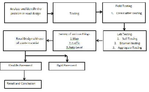
4. METHODOLOGY
The methodology adopted would be studying and identifying with the existing conditions. We had studied map, auto level survey and traffic survey then we have done the soil test in lab as well as on field then we have design the road flexible pavement.
5. STUDY AREA LOCATION
[image:3.595.43.290.195.348.2]Avlote is a small village it comes under ‘Group Gram Panchayat Pundas’ Bhiwandi of district Thane, Maharashtra. Nearest railway station from Avlote is Khadavli. Distance of Khadavli from Avlote is 10 km. The transportation of Avlote is risky, hard rock patches. That region comes under forest area.Avlote is an village in Padgha, District-Thane, State-Maharashtra. Popular language in Avlote is Marathi; income source of Avlote is farming. Crop production is Rice, Vegetables and Groats.Avlote is a medium village which is connected with other villages such as Vadacha Pada, Marathe Pada, Shelar Pada, Latyacha Pada, Koshimbe etc, and all this villagers required this road for transportation facility.
Figure 1 – Satellite Image of Selected Area of the Project
6. DATA COLLECTIONS
Collecting the data and quantifying the information from a survey in the field or the study area in a systematic path in order to get proper and scrupulous picture of an area
of interest, also to analyze and evaluate the outcomes and retort to the research problems.
6.1 Surveying
Surveys are carried out before starting the project such as Map study, Reconnaissance survey, Preliminary survey, Final location. Map study is to have a rough idea of the field. Reconnaissance survey is to visit the site and scrutinize the main features of the area but not in detail. The data derived from the reconnaissance surveys are normally utilized for planning and programming the detailed surveys and investigations and few possible alignments can be chosen for any alteration or changes. In Preliminary surveys, survey specialists and party perform field surveying duties using a total station and collects all data which are necessary like latitude, longitude, elevation and other required measurements and data in the alternate alignments proposed. At last, final locating the center line of the ground.
6.2 Traffic Volume count
To decide the number of lanes and roadway width, pavement design, economic analysis traffic surveys are conducted. The main focus of traffic survey is to determine vehicle composition in traffic stream which helps to design geometric features of the road.
Cumulative ESAL applications over 10 years @ 6% growth rate,
Where,
T˳ = ESAL per day = number of commercial vehicles per day in the year of opening × VDF
L = Lane distribution factor = 1 for single lane / intermediate lane
Assuming a uniform annual growth rate “r” of 15% over the design life (n) of 10 years
Cumulative ESAL applications (N) over the design life can be computed by substituting the values,
N= 1550453
Therefore, ESAL = 155045
© 2019, IRJET | Impact Factor value: 7.211 | ISO 9001:2008 Certified Journal | Page 2204
7. DESIGN OF FLEXIBLE PAVEMENT FOR 10 YEARS ASPER IRC: SP: 72-2015 Data,
1. Single lane two carriageway = 1 2. PCU = 4514
3. No. of commercial vehicles as per last count (P) = 45 CVPD
4. Traffic growth rate per annum (r) = 15% 5. Design life (n) = 10 years
6. Vehicle damage factor (F) = 3.50 7. CBR of subgrade soil = 8% 8. Lane distribution factor (D) = 1
9. Initial Traffic in the year of completion of construction in Terms of the number of commercial vehicles per day (A)
A=52
Calculations of MSA is given formula,
N=2.59
For traffic category “T9” obtained from traffic analysis, Design crust for 3 msa based on pavement design catalogues for gravel/ gravel bases and sub-bases as per code is tabulated as below.
8. OUTPUT OF DESIGN
Drawings are the ensue possess for the discourse pathway and simultaneously tabular pillar are procreate automatically with dope.
We will get the confirmation direct, misfortune portion, turn inside information along with the enlightenment of intensity of carve and fill (Earthwork greatness) for the whole design expand.
Graph 1- Proposed Design of ground level
9. CONCLUSIONS
Basic needs: Medical facility in the village, food supply Education facility and living lifestyle of the villages.
Social Needs: Transportation facility will reduce the time travel required for travelling purpose, enhancing the agriculture as well as Industrialization hence the financial ability of the village.
Economy Needs: The construction cost reduced by using naturally available material.
REFERENCES
[1] Nisarga K. and Vinoda Amate, “Geometric Design of Rural Road using Auto CAD Civil 3D,” IRJET, vol.: 5, Issue:7, ISSN:2395-0072.
[2] Jhonsan k. Appiah, Victo N. Berko-Boateng and Trinity A. Tagbor, “Use of waste plastic material for road construction in Ghana”, Science direct, Case Study in Construction Materials 6.
[3] Wolfgang Kuhn, “All round methodology for upgrading existing rural roads that are prone to accidental using virtual driving simulation” transportation Research Procedia 25 (2017).
[4] Pradeep Kumar Samanta, “development of Rural Road Infrastructure in India” Pacific Business Review international, Vol-7, Issue-11, May-2015.
[5] Pawan D. and Sunil S., “Design and Construction of Low Volume Rural roads using Reclaimed Materials”, National Conference on Recent Research Advances in Civil Engineering, Osmania University, 7– 8 November, 2014.
[6] Asif Faiz, Aysha Faiz,Wei Wang and Cristhopher Bennett, “Sustainable rural roads for livelihoods and livability,” Social behavioral Science 53-2012.
BIOGRAPHIES
© 2019, IRJET | Impact Factor value: 7.211 | ISO 9001:2008 Certified Journal | Page 2205
Shreya C. Sawakhande perusingBachelor’s Degree from Dilkap Research Institute of Engineering & Management Studies.
Sheetal B. Patil perusing Bachelor’s Degree from Dilkap Research Institute of Engineering & Management Studies.
Pooja K. Tarmale perusing Bachelor’s Degree from Dilkap Research Institute of Engineering & Management Studies.