Identification of Indian Road Distress with Ruleset
using Image Processing
Suwarna Gothane1, Dr. M. V. Sarode2, Dr. V.M. Thakre3
1
Associate Professor, CSE Dept, CMR Technical Campus, Hyderabad, India, Research Scholar, Sant Gadge Baba Amravati University, India.
2
Head of CSE Dept, Government Polytechnic, Yavatmal, India.
3
Professor, Sant Gadge Baba Amravati University, India.
Abstract: Cracks are a growing threat to road conditions and have drawn much attention to the construction of smart transportation systems. Automatic road crack detection has been challenged because of the intense inhomogeneity along the cracks, the topology complexity of cracks, the inference of noises with similar texture to the cracks, and so on. However, the difficult nature of pavement images, the small size of defects lead to the fact that inspection in this area is done mostly manually. Further cracks can lead to potholes and causes obstacles for smooth driving. In this paper, we defined ruleset based on extracted parameter for road images for identification of cracks, patches and potholes.
Keywords: road distress, cracks, potholes, patches, Ruleset.
I. INTRODUCTION
Survey of roadway conditions is significant job to assure road safety. The purpose is to detect surface problem, initially raveling and cracking, for planning effective road maintenance with sustainability .The most common type of surface distress is cracking. Cracks on the road surface slow down the performance on road and hence demands for the road safety[1]. Much of the efforts have been made by Governments for developing quality road network. Road maintenance systems vital step includes as major role crack detection. Earlier manual road crack detection techniques was time-consuming, dangerous, labor-intensive and subjective [2]– [5].Detecting a crack manually is a very intricate and time consuming process. As science and technology evolved more focus reached towards automation to identify cracks with cleverness. Automated approach shown benefit in terms of time and cost reduction for detecting the cracks with accuracy.
Various algorithms have been proposed and are used as an automated systems to detect cracks. Manual inspection gradually shifted towards automatic source of data collection at high speed using cameras on vehicles [6]. Data processing and surface condition monitoring and collecting history of the imaging devices in [7]. Charge-Coupled Device, attainment techniques provided better results for occurrence of cracks by pixel intensities.
Emerging 3D imaging technology from past years found beneficial based on the elevation data. Giving priority to safe driving suitable plan of maintenance and analysis of the road distress is required.
The major hurdle on road are potholes compromise result in vehicle damage. Timely repairing potholes is crucial in ensuring the safety, quality of driving, and reducing the cost of vehicle maintenance. Pavement condition assessment is vital with emergent road network maintenance work. To the larger extent data collection process becomes automated where as road disease identification such as cracks, potholes, etc. is more often performed manually, which is labour-intensive and time-consuming. Obtainable approaches move toward a high equipment and working out expensive. Pothole are one of the primary cause of accidents, hence detection and classification is crucial. Potholes though seem inconsequential, may cause accidents resulting in loss of human life. Road performance can be monitored by observing its structural and functional performance or predicting the serviceability of a road from its initial service time to the desired evaluation time.
Generally, road condition can be evaluated on the basis of four aspects i.e. riding quality, surface distress, structural capacity and skid resistance.
II. RELATED WORK
Yong Shi et.al [8] developed automatic road crack detection using random structured forests technique called CrackForest, with intensity inhomogeneity approach. Author generated a high performance crack detector, identified arbitrarily complex cracks and characterize them effectively. Method found is faster and easier than parallel work. Nouha Ben Cheikh et.al.[9] developed Automatic Crack Detection From Using Fuzzy Thresholding implemented in a Matlab prototype, trained and tested on 330 real pavement images. The results show that this method can detect a crack in pavement images with reasonable accuracy. Rabih
Amhaz, [10] developed Automatic Crack Detection on Two-Dimensional Pavement Image based on Minimal Path Selection
algorithm. An approach used the photometric and geometric characteristics of pavement images. An intensive validation is performed on both synthetic and real images (from five different acquisition systems), with comparisons to five existing methods. The proposed algorithm provides very robust and precise results in a wide range of situations, in a fully unsupervised manner.
Amila Akagic et al. [11] worked on Pothole Detection with unsupervised Vision Based Method Using RGB Color Space Image Segmentation. The method is tested on online image data set captured from different cameras and angles, with different irregular shapes and number of potholes. Margaret Velse Thekkethala et al. [12] proposed pothole detection and volume estimation using stereoscopic cameras. In the proposed method, an image is first resized and converted to grayscale. It is then histogram equalized. This is followed by thresholding and basic edge detection using the Sobel filter. Morphological operations such as dilation and eroding are performed and median filtering removes excess noise.
A logical addition of the results obtained till then, results in a relative pothole shape. A structuring element allows for the pothole to be defined and opened and a skeleton of the pothole is formed.
A bifurcation process is applied so as to remove any branches. Subsequently, the result of this operation is used for multiplying image matrices and the pothole is extracted.
This methodology has been implemented in a MATLAB prototype and tested on 24 pavement images. The stereoscopic camera technique is used to improve accuracy and to determine the depth or volume of the pothole. The volume of the pothole may be used to estimate the amount of asphalt material required to fill it. The results indicate that this method can detect potholes in asphalt pavement images with reasonable accuracy.
Vigneshwar. K[13] worked on Detection and Counting of Pothole using Image Processing Techniques. From the results the K-Means clustering based segmentation was preferred for its fastest computing time and edge detection based segmentation is preferred for its specificity. Manisha Mandal et al. [14] worked on automated management of pothole related disasters using image processing and geotagging. An automated system to efficiently manage the potholes in a ward by deploying geotagging and image processing techniques that overcomes the drawbacks associated with the existing survey-oriented systems.
Image processing is used for identification of target pothole regions in the 2D images using edge detection and morphological image processing operations.
A method is developed to accurately estimate the dimensions of the potholes from their images, analyze their area and depth, estimate the quantity of filling material required and therefore enabling pothole attendance on a priority basis.
This will further enable the government official to have a fully automated system for effectively managing pothole related disasters.
Ankita Khatri et al. [15] worked on Image Processing techniques for maintenance of roads by observing its structural and functional performance or predicting the serviceability of a road from its initial service time to the desired evaluation time.
III. PROPOSED WORK
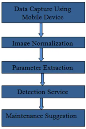
Proposed framework consider goal to perform most accurate detection of cracks, potholes and patches. Here capture device is used to capture images of road surface. In order to reduce noise we have applied preprocessing step on input images. We have extracted parameters from the images dataset which is available in [16].This work make use of results of earlier work of Suwarna et al. Henceforth, after noise removal, parameter extraction, we have perform detection of the cracks, potholes and patch works. This information can be further useful for maintenance of road distress.
The proposed framework is shown in Fig.1
Fig.1: Proposed Technique for Road Distress Detection
IV. IMPLEMENTATION
We have implemented results in Matlab. Here we defined Ruleset to identify cracks, patches and potholes and identified maximum and minimum range. And finally perform classification of defect into Ruleset 1 for cracks, Rule set 2 for patches, Ruleset 3 for potholes.
Classification of defects and rule based classification engine is shown in [Table -1].
Rule Set - 1 (Cracks)
Parameters Min Range Max Range
longSlope 1.47 -0.63
perpendicularSlope -0.68 1.59
Number of Objects 1 1
Max distance between Objects 295.11 623.71
Perpendicular distance at midpoint 120.64 321.14
Average perpendicular width 92.97 222.99
Rule Set - 2 (Patches)
Parameters Min Range Max Range
longSlope 0.88 0.14
perpendicularSlope -1.14 -7.06
Number of Objects 1 1
Max distance between Objects 172.9 384.81
Perpendicular distance at midpoint 77.16 54.36
Average perpendicular width 49.83 61.93
Rule Set - 3 (Potholes)
Parameters Min Range Max Range
longSlope 0.55 0.5
perpendicularSlope -1.83 -2.02
Number of Objects 1 1
Max distance between Objects 756.75 1314.82
Perpendicular distance at midpoint 222.79 650.43
[image:3.612.239.379.95.303.2]Average perpendicular width 187.72 522.15
V. CONCLUSION
In this work we defined ruleset to identify cracks, patches and potholes and identified maximum and minimum range. We considered parameters long slope, perpendicular slope, number of objects, maximum distance between objects perpendicular distance of midpoint, average perpendicular width and identified minimum and maximum range for the cracks, patches and potholes.
REFERENCES
[1] H. Oliveira and P. L. Correia, “Automatic road crack segmentation using entropy and image dynamic thresholding”, in Proc. 17th EUSIPCO, , pp. 622–626, Aug. 24–28, 2009.
[2] H. Cheng, J.R. Chen, C. Glazier, and Y. Hu, “Novel approach to pavement cracking detection based on fuzzy set theory”, J. Comput. Civil Eng., vol. 13, no. 4, pp. 270–280, Oct. 1999.
[3] H. Cheng et al., “Novel approach to pavement cracking detection based on neural network”, Transp. Res. Rec., J. Transp. Res. Board, vol. 1764, pp. 119–127, 2001.
[4] P. Subirats, J. Dumoulin, V. Legeay, D. Barba, “Automation of pavement surface crack detection using the continuous wavelet transform”, in Proc. IEEE Int. Conf. Image Process., pp. 3037–3040, 2006.
[5] T. S. Nguyen, M. Avila, S. Begot,“Automatic detection and classification of defect on road pavement using anisotropy measure”, in Proc. Eur. Signal Process. Conf., pp. 617–621, 2009.
[6] M. Ahmed and C. Haas, “The potential of low cost close range photogrammetry towards unified automatic pavement distress surveying”, presented at the Transportation Research Board Meeting, Washington, DC, USA, 2009.
[7] M. Gavilán et al.,“Adaptive road crack detection system by pavement classification”, Sensors, vol. 11, pp. 9628–9657, 2011.
[8] Yong Shi, Limeng Cui, Zhiquan Qi, Fan Meng, and Zhensong Chen, “Automatic Road Crack Detection Using Random Structured Forests”, IEEE Transactions On Intelligent Transportation Systems, pp. 3434-3445, Vol. 17, No. 12, December 2016.
[9] Nouha Ben Cheikh Ahmed1,Samer Lahouar, Chokri Souani, Kamel Besbes, “Automatic Crack Detection From Pavement Images Using Fuzzy Thresholding”,ICCAD’17, Hammamet - Tunisia, January 19-21, 2017.pp.528-533,IEEE 2017.
[10] Rabih Amhaz, Sylvie Chambon, Jérôme Idier, Member, IEEE, and Vincent Baltazart, “Automatic Crack Detection on Two-Dimensional Pavement Images: An Algorithm Basedon Minimal Path Selection”,IEEE Transactions On Intelligent Transportation Systems,pp.2718-2729, Vol. 17, No. 10, October 2016. [11] Amila Akagic, Emir Buza, Samir Omanovic, “Pothole Detection: An Efficient Vision Based Method Using RGB Color Space Image
Segmentation”,MIPRO2017,Opatija, Croatia.pp.1104-1109, May 22- 26, 2017.
[12] Margaret Velse Thekkethala, Reshma S, Sebin Jacob Varughese, Vaishnavi Mohan, Geevarghese Titus, “Pothole Detection And Volume Estimation Using Stereoscopic Cameras”, International Journal of Industrial Electronics and Electrical Engineering, ISSN: 2347-6982 Volume-4, Issue-5, May 2016.
[13] Vigneshwar. K, “Detection and Counting of Pothole using Image Processing Techniques”, 2016 IEEE International Conference on Computational Intelligence and Computing Research IEEE, 2016.
[14] Manisha Mandal, Madhura Katageri, Mansi Gandhi, Navin Koregaonkar, Sharmila Sengupta, “Automated Management Of Pothole related Disasters Using Image Processing And Geotagging”, International Journal of Computer Science & Information Technology (IJCSIT) Vol. 7, No 6, December 2015.
[15] Ankita Khatri,Umesh Sharma, “Image Processing techniques for maintenance of roads”, Int'l Journal of Research in Chemical, Metallurgical and Civil Engg. (IJRCMCE) Vol. 3, Issue 2 (2016) ISSN 2349-1442 EISSN 2349-1450, 2016.
[16] Suwarna Gothane, M.V.Sarode, V.M.Thakre,“An Automatic Framework for Parameter Extraction from Road Images with Potholes”, 2018.
AUTHORS PROFILE
Suwarna Gothane is presently working as an Associate Professor in CMR Technical campus, Hyderabad, Telangana, India. She is pursuing Ph.D. from Sant Gadge Baba Amravati University. She received her M.E (CSE) degree from P.R.M.I.T & R, Amravati in the year 2012. She received B.E. (CSE) degree from H.V.P.M C.O.E & T, in the year 2006. Her areas of interests are Data Mining, Image Processing, Machine learning etc.
Dr. Milindkumar Sarode currently working as HOD. GovernmentPolytechnic, Yavatmal, India. He has completed his