1189
©IJRASET: All Rights are Reserved
Advanced Road Safety for Ghat Roads at Amboli
Prof. A. S. Manjarekar
1,Rushikesh Majale
2, Preetkumar Patel
3, Indrajeet Patil
4, Prajakta Dudhal
5, Dhanashri Chavan
61Assistant Professor, Civil Engg. Department, 2, 3, 4, 5, 6Student of Final Year B. E. Civil Sanjay Ghodawat Institutions, Atigre,
ShivajiUniversity, Kolhapur, India
Abstract: According to Government of India, Ministry of road transport and highway transport research wing, New Delhi, the regions of western ghat starting from Gujarat, Maharashtra, Goa, Karnataka, Kerala comes under accidents above 30,000 per year (2016). Among which, Amboli located in Sindhudurg district of Maharashtra has extreme curved ghat section, resulting in maximum number of accidents. This study is based on the actual minimization of accidents, from the study area Amboli ghat. We tried to study the theoretical road accidents, increase in rate of road accidents. We are giving the problems which were identified by us. Also we are suggesting the theoretical based solutions, which we are going to work practically to make Amboli ghat safer to drive.
Keywords: Head on collision, collision on gurad rail, road design parameters, retaining structure
I. INTRODUCTION
Road traffic accidents and deaths caused by them are most critical issue now-a-days. It also impact in countries economy mostly in hilly areas. Ghat Roads are access routes into the mountainous with number of hairpin bends, which is very risky as compare to normal routes. So chances of accidents in ghat section is more because of narrow road width, sharp bends, improper camber, valley side etc. Accidents due to poor development of national highways and hazard zone. In India rate of accidents in ghat section increasing day by day. These study includes important issues like road accidents and their impacts, causes of these accidents, effects of accidents, prevention and control that we can improve this situation. Also it is not safe now a days to cross the ghat while having any long journey. As we know rate of accidents on ghat roads is increasing day by day. Number of reasons are there for these types of accidents such as speed, improper design of hilly roads, and width of road. While driving on roads at ghat section many drivers faces accident which results them into serious injuries or even death the main reason behind this accident is curves and bends of roads while turning in Ghats. It becomes difficult to see vehicles coming from other lane and turning drivers usually have to assume a way for turning at such critical section this creates a great risk of life other reason for accident in ghat section is that only one vehicle can turn at turnings at a time. So it is first important to control this scenario and have some safety measures in ghat area. This project includes some solutions and ideas to improve safety in ghat areas. While driving on roads at ghat section many drivers faces accident which results them into serious injuries or even death the main reason behind this accident is curves and bends of roads while turning in Ghats. It becomes difficult to see vehicles coming from other lane and turning drivers usually have to assume a way for turning at such critical section this creates a great risk of life other reason for accident in Ghat section is that only one vehicle can turn at turnings at a time. While driving on roads at ghats section many drivers faces accidents which result them into serious injuries or even death. The main reason behind this accidents is curves and bends of road while turning in ghats. It becomes difficult to see vehicle coming from other lane at turning. If two vehicles comes face to face while turning it creates a chance of accidents and it becomes difficult to handle. At night, due to no streetlights it becomes a difficult task of driving on ghats and especially while turning. It becomes more difficult at night to make a turn as vehicle coming from another side of road is not visible due to obstruction and darkness. Severity of this accidents are non-reparable. Road traffic accidents (RTA) are responsible for 1.2 million deaths worldwide each year. So it is first important to control this scenario and have some safety measures in ghat area. This project includes some solutions and ideas to improve safety in ghat areas.
II. OBJECTIVE
In present programme the performance of Amboli ghat road is studied with various parameters for the improvement of road conditions and minimisation of road accidents. This programme is planned to study the following objective
1) To carry out preliminary survey of Amboli ghat area.
2) To study the accidental data of ghat section.
3) To check various design parameters of roads and retaining structures in ghat section.
4) To provide remedial measures for current accidental problems such as modification of roads and its parameters.
5) To design retaining structures for ghat section as per requirement.
1190
©IJRASET: All Rights are Reserved
III.STUDYAREA
According to state highway accidental records of Maharashtra region Amboli comes under Western Ghats with extreme curves and valley side road as, results in maximum number of accident per year. Valleys in area are non accessible, sliding roads due to heavy rainfall, low vision and lightning issues, improper arrangement of road markings, and low strength of guard rails are some reasons for increase in rate of accidents; to resolve these issues Amboli is selected as a study area.
Historically, Amboli village came into being as one of the staging posts along the road from Vengurla port to the city of Belgaum, which was extensively used by the British to supply their garrisons in south and central India.
The sources of Hiranyakeshi River lies in the hills around Amboli village, and an ancient Shiva temple sits at the cave where the water emerges. The main attraction for tourists is the in credibly- high rainfall (7mm average, per year.) and the numerous waterfalls and mist during the Monsoons. Legend has it that there are 108 Shiva temples in and around Amboli, of which only a dozen have been uncovered, one as recently as 2005.
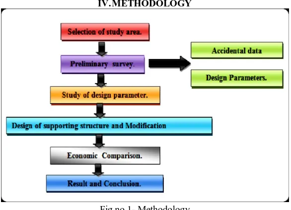
[image:2.595.152.445.264.476.2]IV.METHODOLOGY
Fig no.1- Methodology
Activities which are taken grouped to prepare the detailed project report as shown in fig 1.The data collected from preliminary survey including secondary sources have been collected, compiled and analysed. The designs solutions on predefined proposed route are provided to make safe drive.
A. Steps Of Methodology
1) Step I: Selection of study area: First, after analysing different roads, traffic conditions, flow of traffic, causes of accidents we choose the Amboli ghat as our study area (which is from Amboli to Danoli is 13.8 km)
2) Step II: Preliminary survey: We divide the preliminary survey in 2 phases
a) Accidental data
b) Design parameters.
i) Accidental data- for collecting this data we took the interviews of local, tourists, security officials and also collect data about
accidents from police station.
ii) Design parameters- for this we conduct actual survey on existing road and design parameters. We check are as follows;
superelevation, camber, gradient, available visibility by eye estimation etc.
3) Step III: Study of design parameters: After collecting the data from the field we check the parameters by comparing with standard given by IRC from that we come to know present condition of the road and what are the modifications required.
4) Step IV: Design of supporting structure and modification: After analysing the condition of road, present condition of guard rail, retaining structure over there we find out that guard rail, retaining structure are not properly maintained, Road sign boards are also not in good condition some are in good conditions but some required to be properly maintain
1191
©IJRASET: All Rights are Reserved
V. WORKING
[image:3.595.95.497.178.335.2]After studying the analytical part of project, we decided to carry out the preliminary survey which would give us a brief idea about the problems faced by road users. We prepared a questionary sheet according to analysed problems. This survey gave an idea that modification of road would be required. So we carried out detail survey i.e. design parameters of road and retaining wall structures.
Fig no.2- Study parameters
1) Preliminary Survey
1) Theoretical information collection: After selection of study area we collect some information about the Amboli Ghat from that
we come to know that we have to perform preliminary survey over there. The basic aim of conducting preliminary survey is that to set direction of our project, and for getting information about the road condition, weather condition, traffic problem, facilities available, road parameters such as visibility on road, curves present on road, shoulder width available, parking available on road etc. for preliminary survey we decided to take personal interviews of peoples who are the residential of that area , always visit that place, and the persons who maintain that road. To fulfil that purpose we prepare questionary local peoples, security officials, and tourist.
Current Situations
a) Condition of Road: - Potholes are formed due to repetitive action of vehicles and rutting effect. Due to heavy transportation of
vehicle, rutting may cause which lead to form potholes. As we know Amboli ghat comes under the category of heavy rainfall zone, due to heavy rainfall these is corrosion of the road which may causes undulation of roads.
b) Road Marking and Signs: - Sign boards in ghat section are kept at a low height so that it cannot be visible to all the drivers.
Some sign boards are obstructed by branches of the trees, and also are not in proper conditions, driver may have chance to meet can accident. Road markings are also not visible to know the alignment and side margins of the lane. Sign that have fallen or cannot be seen because of over grown foliage.
c) Traffic and Parking Problems: - Amboli is a ghat which connects Kolhapur and Sawantwadi. Due to transportation these is huge
traffic. Amboli waterfall is a tourist attraction which is present in Amboli ghat itself. Due to this reason there is heavy traffic in the ghat. The width of road does not satisfy the traffic problems. Overtaking is near to impossible in ghat section due to less width of road. Shoulders are present nearly about 80% of the ghat section, but remaining 20% of ghat section is without shoulders. At the time of emergency it may lead accidental problems.
d) High Speed collision on guard rail: - In case of Amboli accidents cause due to the low strength of existing guard rail. Material
used for guard is not strong enough to take impact. Most of the guard rail is covered with algae, which is not acceptable. Guard rail must be strong but at Amboli guard rails are not well maintain mostly made up of ‘chira’ and stone masonry.
e) Accident Due to Head on Collision: - Main causes for head on collision re accident may cause due to the improper geometric
design of road such as less shoulder width available, heavy curves, low maintenance, less visibility or sight distance available, proper super elevation is not present, second main cause behind accident due to head on collision is current road not satisfies the great traffic load.
f) Landslide zone:- Indiahasthehighestmountain chain on earth. The landslides which are occurred due to continuous stress on
1192
©IJRASET: All Rights are Reserved
2) Problem Identification
After studying various conditions in ghat wedecided to divide our study as per accidental issues in Amboli ghats and other issues in
Amboi ghat
According to the accidental issues it is further classify as accident due to the,
1) Accident Due To Head On Collision: Main causes for head on collision re accident may cause due to the improper geometric design of road such as less shoulder width available, heavy curves, low maintenance, less visibility or sight distance available, proper super elevation is not present, second main cause behind accident due to head on collision is current road not satisfies the great traffic load. The existing road is having less capacity than required. It should be made to meet high traffic. Physical and mental conditions of the driver- Due to mental condition such as, anxiety, stress, and fatigue problem driver may face accidents. Also according to local people interviews we come to know that main cause behind the accident is human problem like drunk and drive cases. Rules are not followed by the tourist peoples. At waterfall more security should be provided during the rainy season. According to our preliminary survey if the count of accident is taken then accidents due to human problems, because of negligence are more.
2) High Speed Collision On Guard Rail: Guard rail are mainly provided to prevent collapse of vehicle in valley side or slopping side, so that guard rail must be strong enough to take the impact of vehicle in case of accident. It should prevent falling of vehicle in the valley. In case of Amboli accidents cause due to the low strength of existing guard rail. Material used for guard is not strong enough to take impact. Most of the guard rail is covered with algae, which is not acceptable. Guard rail must be strong but at Amboli guard rails are not well maintain mostly made up of ‘chira’ and stone masonry and not well maintain. If we saw the area of Amboli heavy rainfall is there due to this proper maintenance is required.
3) Detailed Survey
1) Need of Detailed survey: After 1st survey collecting the information we come to know that detail survey of Amboli is required.
a) To check various geometric parameters of road such as super elevation, width, shoulder, sight distance.
b) To compare existing parameters of road with standards.
c) To find out any modifications if possible.
d) To provide all over safety while riding over that road.
2) Geometric parameters: Detailed survey included by width of carriage way, super-elevation, shoulder width, latitude and
longitude by ‘GPS essential’ app. Sight distance by eye vision, strength of retaining wall and guard rail by Rebound hammer.
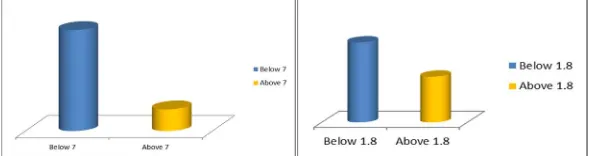
a) Width of carriage way:-Width of carriage way was measured at an every interval of 0.5 km. At also at curves. By using
[image:4.595.146.441.513.591.2]measuring tape, it was measured in to in distance between side margins of road in metric unit. As per IRC 52-2001 carriage width for NH double lane is min 7 m, but in Amboli there was very much variations.
Fig no.3- Variation of carriage way width Fig no.4- Variation of shoulder width
b) Super-Elevation: Super-elevation was measured by using Auto-level and reading staff. At the end of width of the road, two consecutive staff reading were taken with the help of Auto-level. The difference between the two staff reading is the super-elevation. As per IRC recommendations super elevation is 0.65 m.
c) Width of Shoulder: Width of shoulder was measured with the help of measuring tape. Width of the shoulder was measured from the outer side of the side margin. As per IRC 52-2001 it is min 1.8 m.
d) Latitude and Longitude: By the use of GPS Essential mobile application latitude and longitude of the each curve was noted. This mobile application was used because this application don’t require the internet connection, as there is poor network in Amboli ghat. This app only requires GPS system.
e) Strength of retaining wall and guard rail: - By the use Rebound hammer we conducted NDT test. Strength of the RCC retaining
1193
[image:5.595.221.374.110.220.2]©IJRASET: All Rights are Reserved
Fig no.5- Guard rail strength
VI.MODIFICATIONS&SOLUTIONS
For provision of solution we categorized this ghat into 3 stages, based on risk factor and vision factor. The risk zones are divided on the basis of various factors such as physical road conditions, intensity of curve i.e. sharp curve or smooth curve, critical points in ghat sections like waterfall, sunset point etc. There are total 107 curves are present in that some curves are critical as like hairpin bend and some are less critical.
Vision zones are also be divided. In some part of the ghat section there are obstacles are present. Trees branches are grows across the road also in rainy season due to smog and foggy environment vision problems are arrived.
[image:5.595.92.269.349.449.2]For Amboli ghat road this is made us easy to provide separate and different solution & such separation will lead to achieve economy of project.
Fig no.6- Risk factor Fig no.7- Vision factor
Possible modifications and solutions-
A. Design parameters modification
1) Width increment with shoulder modification
2) Super elevation changes
B. Modification based on vision factor
1) Provision of mirrors, speed limits, speed retarders, lights provision, etc.
C. Modifications for road marking and sign boards
1) Provision of cat eyes, digital or radium based regulatory, informative, warning sign boards.
D. Other solutions
1) improvement of tourist stations base on security and parking problems
2) Provision of virtual security( speed check cameras, alcohol check cameras, recording cameras ) and Stand by unit facility
(ambulance, fire station, cranes)
3) Retaining and drainage provision
4) Control room linked with police, forest, medical departments and stand by units.
E. Provision of sensor type guard rail.
1) W- beam (metal crash barrier) for low risk zone
2) Pre-stressed cable barrier for medium risk zone
[image:5.595.336.506.350.447.2]1194
©IJRASET: All Rights are Reserved
VII. CONCLUSION
From this study we conclude by providing above modification, we can make Amboli ghat safe for traveling. Also from data collection we came to know that accidents occurs in Amboli are mostly because of carelessness of driver having no information about the road, drunk and drive cases. For that awaring the people and also providing check post at suitable location is best solution. As Amboli receives max rainfall so that the wear and tear of road is happened for that it is necessary to periodic maintenance of road, use standard quality material so that road can provide service for longer time. In this study we try to provide best solutions so that accidents can be reduce with economy and people feel safe while using the road.
REFERANCES [1] IRC 51-2001 Recommendations about the alignment survey and geometric design of hill road.
[2] Abdul Rahool, Bipin Kumar Singh, civil Engineering department,NMS University Rajasthan India publish a paper on “Road safety and Road Safety Audit in India: A review’’. In International jorunal paper ISSN:2347-4718 Volume 4 issue on 7 March 2017
[3] R.Arulmozhi & T.Subramani Tamil Nadu Highways Department, Salem, Tamil Nadu, India Department of Mining Engineering, publish a paper on “Ghat Road Alignment in Palamalai Hills,Tamil Nadu, India using Ghat Traces, GPS & GIS .”In Indian journal of Geo-Marine Science PP-1162-1171 Volume 45(9), issue on September 2016
[4] Ranganathan.B.A ,Associate Professor, Dept.of Civil Engineering ,New Horizon College of Engineering Bengalure publish a paper on “Road Safety & Accident Prevention” in India in International Research journal of Engineering & Technology e-ISSN-2395-0056, P-ISSN:2395:0072 Volume 3 issue on 6 June 2016
[5] Nicholas S. Johnson & Hampton C. Gabler Graduate Research Engineer, and Professor, Mehanical and Biochemical Engineering Virginia Tech publish a paper on Injury “Risk in Frontal Crashes With Guardrail and Guard Rail End Terminals” submitted to 93 Annual Meeting of The Transporation Research Board on 15 Nov 2013
[6] S. P. Bhumkar, V. V. Deotare, R. V. Babar. Sinhgad Institute Of Technology, Lonavala, Pune, India publish a paper on “Accident Avoidance and Detection on Highways” in International Journal of Engineering Trends and Technology-Volume-3, Issue2- 2012
[7] Hitransh Srivastava, Nikhil Acharya, Fervez Jaffer B. M. , Sachin Bhat. Manipal University, Visvesvaraya Technological University, Visvesvaraya Technological University, Reva University publish a paper on “Implementation of Collision Avoidance System for Hairpin Bends in Ghats using Proximity Sensores” in Volume-3, Issue-11, 2016
[8] Basim K. Jrew T. Abdl Razzak, Ziboona and Deleen Mohamed Saleh, Evaluation of the Use of Remote Sensing Techniques for Highway Alignment Layout, Jordan Journal of Civil Engineering, 2 (2) (2008).
[9] R. S. Rakul S. Ravia K. N. Thirukkuralkani, “Implementation Of Vehicle Mishap Averting System Using Arduino Microcontroller”, International Journal of Engineering Research and Technology, Volume- 5, Issue-04, April-2016.