Multi-layered Annotation of Non-textual Data for Spatial Information
Kiyong Lee
Korea University, Department of Linguistics
Seoul, Korea
[email protected]
Abstract
Spatial and spatio-temporal information is of-ten carried by non-textual data such as maps, diagrams, tables, or pictures, both still and moving, either embedded in a text or stan-dalone. The annotation of nontextual data raises the following questions: (i) what are the markables and how should they be coded? (ii) how should relevant information be inferred which is implicit in the data? We answer these questions with a multilayered approach.
1 Introduction
Non-textual data such as maps, figures, or pictures, either still or moving, are powerful media that carry spatial or spatio-temporal information. This paper concerns the annotation of such data, whether they are embedded in a text or presented alone. As its basic annotation scheme, it followsISO-Space, a se-mantic annotation scheme which was proposed by Pustejvosky et al. (2012) for the annotation of spa-tial information in natural language. It is claimed thatISO-Spacecan be adequately applied to the an-notation of non-textual data as well as text data in natural language.
Section 2 presents partial specification of ISO-Space, section 3 discusses making references to markables, section 4 deals with understanding con-ventions, section 5 illustrates multi-layered annota-tion, and section 6 makes concluding remarks.
2 Partial Specification of
ISO-Space
Given a text (fragment) tL of a language L, the
annotation scheme ASisoSpace of ISO-Space can
be defined formally as a quadruple<M, E, R,@>, whereM is a nonempty finite set of (some selected)
segments oftL, calledmarkables,Ea nonempty
fi-nite set of elements, calledbasic entities, which are either atomic or composite,Ran n-ary (basically
bi-nary) relation overE, and@a set of functions from a set of attributes to a set of values for each ele-mente inE and each relation r in R. One
partic-ular attribute is an attribute, named@target, that anchors a basic atomic entitye inE to a markable
m in M. For the general formulation of an
anno-tation schemeAS, we basically follow Lee (2012), which is slightly different from that of Bunt (2010) or Bunt (2011).
The setM of markables consists of all the
expres-sions, i.e., sequences of tokens or words intL, that
refer to all of the basic entities of each of the types defined byE. These entities include (1) spatial
enti-ties, tagged asPLACEandPATHor (2) entities that are not genuinely spatial, but involve spatial enti-ties, tagged asEVENT, MOTION, SPATIAL NE
(named entity) or SPATIAL SIGNAL. The
setR of n-ary links overE include (1) qualitative
spatial link, (2) orientation link, (3) movement link, and (4) metric link tagged asQSLINK, OLINK, MOVELINK, andMLINK, respectively.
The specification of sets of attribute-value pairs for each of the basic entity types and the links re-quires a complex listing. Each basic entity e in E and each linkr inR has a unique ID, specified with the attribute@xml:idin XML representation. Each basic entityeis anchored to a markable inM,
iftLis atokenizedtext. Note that there are two types
of basic entities,atomicandcomposite. Atomic ba-sic entities are simply anchored to a markable in
M, whereas composite basic entities are anchored
to other basic entities as well as to markables. The entity typePLACE, for instance, is anatomicentity type, while the entity typePATHis acomposite en-tity type, for the latter is anchored toPLACEs.
Instead of presentingASisoSpaceas a whole as is
formally defined, we may introduce it only partially and also in an informal way with some illustrations. For this, consider the following text:
(1) Mia drove to Jeju International Airport yester-day.
This sentence contains 8 tokens including a punctu-ation mark. Out of them,ISO-Spaceselects 6 tokens and treats them as four markables, “Mia”, “drove”, “to”, and “Jeju International Airport”, as shown be-low:
(2) Miatoken1 drovetoken2 totoken3 Jejutoken4 Internationaltoken5Airporttoken6yesterday.
Corresponding to the four markables, four basic entities are introduced: SPATIAL NE, MOTION, SPATIAL SIGNALandPLACE. A link is also in-troduced:<MOVELINK>. Each of them is specified with a list of appropriate attribute-value assignments with some modifications on the current list of ISO-Space, as is represented in XML as follows:1
(3) <isoSpace>
<SPATIAL NE xml:id="sne1" target="#token1" type="PERSON" form="NAME"/>
<MOTION xml:id="m1" target="#token2" motion type="MANNER"
motion class="MOVE EXTERNAL"/> <SPATIAL SIGNAL xml:id="s1" target="#token3"/>
<PLACE xml:id="pl1"
target="#(token4,token6)"
1We have introduced attribute-value pairs such as type=
"PERSON"for the annotion of “Mia”, and alsotype="FAC"
andsubtype="AIRPORT"for that of “Jeju International Air-port”.
type="FAC" subtype="AIRPORT" form="NAME"/>
<MOVELINK xml:id="mvl1" trigger="#m1" goal="#pl1"
mover="#sne1" goal reached="YES"/> </isoSpace>
This annotation is then understood as conveying the information that there are four types of basic entities involving spatial information: spatial named entity, motion, spatial signal, and place, and that there is a relation of linking among these entities. Each entity is further specified with information provided by the assignment of a value to each relevant attribute. The place “Jeju International Airport” is, for instance, specified as FAC (facility type) being an airport. With the attribute@targetspecified as above, each of the four basic entity types <PLACE>, <MOTION>, <SPATIAL SIGNAL>, and <SPATIAL NE> refers to some markable (sequence of tokens) in the text.
The annotation given above then introduces one link, namely<MOVELINK>, among those four ba-sic entities. This link is triggered by the motion (m1) of driving to its goal, the airport (pl1) named “Jeju International Airport”, with its agent (driver) being a person (sne1) named “Mia”. The link, as is anno-tated here, thus fully represents the information con-veyed by the sentence given above. The annotation as a whole can be formally interpreted in first-order logic, as below:
(4) ∃{x, y, e}[person(x) ∧ named(x, M ia) ∧
airport(y) ∧ named(y, JejuInt.Airport) ∧
move external(e)∧agent(x, e)∧goal(y, e)∧
reach(x, y)]
3 Making References to Markables
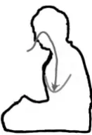
Figure 1: Deep BreathingcGhang Lee
annotation of non-textual data requires techniques more than simply segmenting a text.
Consider Figure 1:Deep Breathing. This figure is introduced as part of a guidebook for teaching how to breathe deep down to the abdomen by expand-ing the diaphragm durexpand-ing the Zen meditation. This figure cannot be segmented into character offsets or tokens, for it contains no characters at all. It rather consists of several geometric objects: (1) an area to-tally enclosed with a boundary line and an open area outside of it, (2) a curved line located within the en-closed area, and (3) a directed line, namely, arrow entering the upper part of the enclosed area and then reaching that curved line located at the lower part of the enclosed area.
The description of these objects may have to be more explicit for the purposes of computing, per-haps requiring the use of such notions as pixels, co-ordinates, orientations or topological properties to make them referable as markables. From ordinary linguistic points of view, however, such a specifica-tion seems to go beyond the level of semantic repre-sentation. It is too complicated to focus on relevant information from the given figure. Instead, we can propose a conventionally more acceptable linguistic technique. Namely, it is to assign a unique name to each of these geometric objects, thus making them uniquely identifiable within a restricted domain and producing a figure such as Figure 2: Deep Breath-ing Annotated. Such a naming technique is espe-cially plausible because the original figure is accom-panied by a title that tells what is being depicted. Be-cause of its titleDeep Breathing, we can conjecture that the figure depicts the process of deep breath-ing, sometimes calleddiaphragmatic breathing, that undergoes the expansion of the diaphragm or the
ab-Figure 2: Deep Breathing AnnotatedcGhang Lee
domen.
With such knowledge, we can give names to (1) the two spatial areas: the enclosed area is named
THE HUMAN BODY, that represents the shape of
the human body with a sitting posture, whereas the open area outside it is named THE AIR; (2) the
three relevant points: the first point is named NOS -TRILS, which lies on the upper left boundary of
the enclosed area, the second point, namedLUNGS,
which is located at the left middle part of the en-closed area, and the third point, named ABDOMEN,
which is located at the mid-lower part of the same enclosed area; and (3) the two lines: the arrow is named IN PATH, which starts from THE AIR area,
goes through theNOSTRILSand theLUNGSand
ter-minates at theABDOMEN, whereas the other line is
namedDIAPHRAGM, which is shown to be stretched
to the ABDOMEN. We should also be able to
rec-ognize two motions: one motion is that of an ob-ject named air which follows through IN PATH,
and the other motion is that of theDIAPHRAGMthat
expands from the LUNGSdown to the ABDOMEN.
Here, two moving objects, air and DIAPHRAGM
can be treated of typeSPATIAL NE, named entities
involving motions in space.
With all these names specified as above, ISO-Space can now be applied to the annotation of the whole figure, as represented inXLMbelow . Besides
introducing two spatial named entities (sne1) and (sne2), it annotates two big areas, one enclosed (pl1) and the other open (pl2), the four places or points (pl3, pll4, pl5, pl6) in the enclosed area as parts of the HUMAN BODY, and a path (pl) from the open
area (pl2), namedTHE AIR, to theABDOMEN(pl6)
involving aMOVE INmotion of air (sne1). There are
[image:3.595.375.450.130.225.2]each of the four places as well as the path to theHU -MAN BODY (pl1) and (2) twoMOVELINKs, one of which (mvl1) annotates the process of breathing air down to theABDOMEN(pl6), while the other (mvl2)
annotates the streching of theDIAPHRAGM(pl5) to
theABDOMEN(pl6).
(5) <isoSpace xml:id="a2"> <SPATIAL NE xml:id="sne1" target="#figure2:air"
type="NATURAL" subtype="AIR"/> <SPATIAL NE xml:id="sne2" target="#figure2:DIAPHRAGM" type="NATURAL"/>
<PLACE xml:id="pl1"
target="#figure2:HUMAN BODY"/> <PLACE xml:id="pl2"
target="#figure2:THE AIR area"/> <PLACE xml:id="pl3"
target="#figure2:NOSTRILS"/> <PLACE xml:id="pl4"
target="#figure2:LUNGS"/> <PLACE xml:id="pl5"
target="#figure2:DIAPHRAGM"/> <PLACE xml:id="pl6"
target="#figure2:ABDOMEN"/> <PATH xml:id="p1"
target="#figure2:ARROW figure" beginPoint="#pl2" midPoint="#pl3,#pl4" endPoint="#pl5"/> <MOTION xml:id="m1" motion type="PATH"
motion class="MOVE INTERNALLY"/> <MOTION xml:id="m2"
motion type="MANNER" motion class="MOVE"/> <QSLINK xml:id="qsl2"
figure="#pl2" ground="#pl1" relType="EC(Externally connected)"/>
<QSLINK xml:id="qsl1"
figure="#pl3" ground="#pl1" relType="TTP(tangential proper part)"/>
<QSLINK xml:id="qsl2"
[image:4.595.319.512.105.231.2]figure="#pl4" ground="#pl1" relType="NTTP(non-tangential
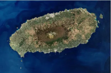
Figure 3: Jeju Island
proper part)/IN"/> <QSLINK xml:id="qsl2"
figure="#pl5" ground="#pl1" relType="NTTP(non-tangential proper part)/IN"/>
<QSLINK xml:id="qsl2"
figure="#pl6" ground="#pl1" relType="NTTP(non-tangential proper part)/IN"/>
<MOVELINK xml:id="mvl1" trigger="#m1" source="#pl2" goal="#pl6" mover="#sne1"
pathID="#p1" goal reached="YES"/> <MOVELINK xml:id="mvl2"
trigger="#m2" source="#pl5" goal="#pl6" mover="#sne2" goal reached="YES"/> </isoSpace>
As is discussed in Mani and Pustejovsky (2012), the relation types such asEC,TTP, andNTTPof
qual-itative spatial link (QSLINK) are defined by the Re-gion Connection Calculus 8 (RCC-8) (Randell et al., 1992) and (Galton, 2000).2 This annotation is then understood as stating that air goes into the abdomen in the human body through the nostrils and the lungs by stretching the diaphragm, as claimed by medita-tion teachers.
Consider another non-textual dataset, Figure 3: Jeju Island.3 This is an aerial photograph of the is-land. Again from the title of the figure, we under-stand that the oval shape refers to Jeju Island. With
2Here,NTTPmay be replaced withIN.
[image:4.595.80.277.209.739.2]Figure 4: Sistine Chapel
plane geometry, we may be able to define the given elliptical region or (near) convex hull and talk about its center or peripheral areas. With some knowledge of reading geographic photographs, we may also be able to derive some geographic information about its mountainous regions, surrounding oceans, attached small isles, and populated areas. We can also refer to each of those areas by drawing (Cartesian) coor-dinate lines, both horizontal and vertical, as detailed as necessary, over the whole photographed area, thus relying on other than linguistic knowledge or tech-niques such as word segmentation.4
In ordinary conversations, as was just claimed, we may prefer to talk about some areas with their specific names rather than their coordinate values. Naming is an important aspect of the ordinary use of language: for instance, naming places with street number, often framed in mapping coordinates, is found very useful especially when we travel to lo-cate places. Knowing directions is also important. But photographs like Figure 3 do not have any place names or street numbers at all. It also fails to tell which is north or south and which is east or west, although they may allow us to measure a distance from one location to another. In section 5, we dis-cuss multi-layered annotation, showing how such an approach combines various types of information, whether non-linguistic or linguistic, to enrich the an-notation of non-textual data such as figures or maps. Note again that one particular layer deals with nam-ing.
Here is a third example, Figure 4:Sistine Chapel. It is again an aerial photograph of St. Peter’s
Basil-4If we are using a Google earth map, then we can simply
rely on the geo-coordinate information provided by it.
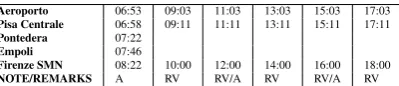
Table 1: Train SchedulecSociet Aeroporto Toscano 2002 - 2008
Aeroporto 06:53 09:03 11:03 13:03 15:03 17:03
Pisa Centrale 06:58 09:11 11:11 13:11 15:11 17:11
Pontedera 07:22
Empoli 07:46
Firenze SMN 08:22 10:00 12:00 14:00 16:00 18:00
NOTE/REMARKS A RV RV/A RV RV/A RV
A= Except on Sundays and Bank Holidays,RV= Fast Regional Connections
ica in the Vatican with some of its surrounding build-ings, one of which is the Sistine Chapel. The pho-tograph itself would not show which building is the Sistine Chapel. The name of the chapel was later printed on the roof of its building in the photograph, Figure 4. We can thus identify the chapel as being located in the upper center of the photograph, stand-ing just next to a smaller dome on the right of the main dome of the basilica when you enter it. Never-theless, we still do not know how to enter it, except guessing that we might be able to enter it through the basilica. (Yes, you can, if you are a Vatican guard or dignitary.) As is again to be discussed in section 5, this photograph with the name of the des-tination can provide an important clue for entering the chapel only when it is annotated with other lay-ers of information.
4 Understanding Conventions
While presenting information in a visually accessi-ble mode, non-textual data such as maps or figures, or even textual data in a tabular form often fail to provide detailed information unless contextual in-formation supplements them. In this section, we discuss how conventional knowledge helps interpret non-textual data.
Consider Table 1: Train Schedule.5 Schedules for transportations such as trains, buses, ships, and planes are very often presented in a tabular form with columns and rows each identified. To be able to read them, however, one must know some con-ventions to interpret them. On the first (left-most) column five train stations are listed in order from the Aeroporto station to the Firenze SMN station, the times on each row list the departure or arrival times of trains at each station, and so on. The 09:03 train from Aeroporto stops at Pisa Central, but runs di-rectly to Firenze without stopping at the other two
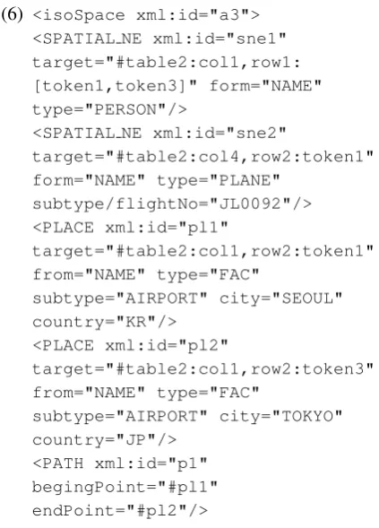
[image:5.595.312.512.125.168.2]Table 2: Flight Schedule
Ms Mia Lee
Gimpo-Haneda (11/30, Fri, 2012) 12:10-14:15 JL0092 Haneda-Gimpo (12/02, Sun, 2012) 15:30-18:05 JL0093
stations in between. One gets all this information if he or she knows how to read the schedule. If one does not know about the convention of presenting such schedules for transportation, she or he may fail to get necessary information.6
Here is another example: a flight schedule given in a tabular form, provided by a travel agent. Know-ing some conventions of printKnow-ing out flight sched-ules, we get proper information about (1) the cus-tomer Ms Mia Lee, who was traveling from Gimpo Airport to Haneda Airport and then from Haneda back to Gimpo, (2) the respective departure and ar-rival dates and times of the on-going and return flights, and (3) the names of the carriers.
With such knowledge, we can annotate this table withISO-Space, as shown below.
(6) <isoSpace xml:id="a3"> <SPATIAL NE xml:id="sne1" target="#table2:col1,row1: [token1,token3]" form="NAME" type="PERSON"/>
<SPATIAL NE xml:id="sne2"
target="#table2:col4,row2:token1" form="NAME" type="PLANE"
subtype/flightNo="JL0092"/> <PLACE xml:id="pl1"
target="#table2:col1,row2:token1" from="NAME" type="FAC"
subtype="AIRPORT" city="SEOUL" country="KR"/>
<PLACE xml:id="pl2"
target="#table2:col1,row2:token3" from="NAME" type="FAC"
subtype="AIRPORT" city="TOKYO" country="JP"/>
<PATH xml:id="p1" begingPoint="#pl1" endPoint="#pl2"/>
6Strcitly speaking, these tables are only partially non-textual. They are non-textual in the sense that they are laid out differently from the ordinary text data.
<MOTION xml:id="m1" motion type="MANNER" motion class="LEAVE"/> <MOTION xml:id="m2" motion type="MANNER" motion class="REACH"/> <MOTION xml:id="m3" motion type="MANNER"
motion class="MOVE EXTERNAL"/> <MOVELINK xml:id="mvl1"
trigger="#m1,#m2" mover="#sne1" means="#sne2" source="#pl1" goal="#pl2" goal reached="YES" pathID="#p1"/>
</isoSpace>
Here three<MOTION>elements are not anchored at all, but only understood through some conventional knowledge involving air flights. These elements should be introduced in order to be able to annotate the departure and arrival-related spatio-temporal in-formation provided in the second and third rows of table 2.
As can be noted very easily, ISO-Space deals with spatial information only. To annotate tempo-ral information, it should be applied jointly with ISO-TimeML (2012). We can then make the ex-ample more interesting and sensible, by annotating various quantitative information of spatio-temporal measurements such as time amount, durations, fre-quency, distance, and also the tense and modal prop-erty of motions or events in general. Lee (2012) has already argued that such a joint application is pos-sible because bothISO-SpaceandISO-TimeMLare designed to be interoperable.
5 Multi-layered Annotation
[image:6.595.76.288.408.703.2]seman-Figure 5: Deep Breathing seman-Figure SegmentedcGhang Lee
tic information, all the information may be too tan-gled up to be retrieved. LAF (2012) thus requires standoff annotation, as opposed to in-line annota-tion, while allowing multi-layered annotation of lin-guistic information. Accordingly, we also argue that a multi-layered approach is not only suitable, but re-quired for the annotation of non-textual data as well as textual data.
For illustration, consider again the figures of deep breathing. In section 3, we have discussed two fig-ures, Figure 1:Deep Breathing and Figure 2:Deep Breathing Annotated. We have then argued how ISO-Spacecan be adequately applied to annotate the figure of deep breathing by making references to the entity names specified in the second figure. Never-theless, one may argue that naming alone is not fine-grained enough to identify regions and other spa-tial entities for some technical applications such as drawing cartoons or architectural designs or even an-notating them. In addition to the technique of nam-ing, we thus propose another technique as providing an additional layer of making it possible to refer to markables in both textual and non-textual data.
This technique is a well-known technique of seg-menting data, whether textual or not, into smaller constituents. Just like maps with geo-coordinates, each (two-dimensional) figure in a text is to be treated like a Cartesian plane, divided into small areas with their coordinates specified.7 Then the character strings and some defining points of the re-gion or its parts such as the nostrils, the lungs, the
7Geo-coordinates or other map reading coordinates are
[image:7.595.326.526.131.266.2]par-ticular instances of the Cartesian coordinate.
Figure 6: Jeju Island-annotated
diaphragm, and the abdomen should be identified strictly in terms of those coordinates, just as a text is segmented into tokens based on character offsets. This technique can be illustrated with the figure of deep breathing. In addition to those two fig-ures, introduced in 3, we can introduce one more figure, Figure 5:Deep Breathing Figure Segmented. This third figure treats the whole region as a two-dimensional Cartesian plane, segmented into 5 x 5 areas with unequal sizes.8 Horizontal and verti-cal lines are drawn in such a way that some rel-evant points can be identified with some of their intersections. The position of the nostrils, for in-stance, is identified with the point (1,4). The non-stretched diaphragm can also be identified as a line segment from (2,2) to (4,2), while its mid-point is being stretched to the point (3,1). Likewise, all of the relevant areas can also be identified by drawing additional lines, if necessary, that segment the whole area into much smaller areas. This then requires an-other layer of representing the whole figure.
For another illustration, consider the following map of Jeju Island, Figure 6:Jeju Island-annotated.9 Unlike the aerial photograph of Jeju, Figure 3, this new figure has names for several locations: (1) Mt. Halla for the mountain located in the center of the island, (2) Jeju City, Seogwipo, and Jungmun Re-sort for three populated areas, and Jeju International
8Quantative information is irrelevant for this particular
ex-ample.
9This file is copyrighted by Jeju Special Self-Governing
[image:7.595.101.238.131.271.2]Figure 7: Jeju Google Earth
Airport for the airport, and Pyeonghwa Route for a highway mostly connecting the airport and Jungmun Resort. The two figures offer different types of geo-graphic information: Figure 3 shows the elevation of each part of the island, while Figure 6 provides in-formation more for traveling around the cities on the island. In Figure 6, there is a little arrow on the left-most upper corner pointing to the north, providing directional information. With this information, we know that the airport is located in the north central boundary of the island. Combined together, these two figures can provide a lot of information that we may or may not be able to derive from a text alone.
Here is a map of the same island, Figure 7 Jeju Google Earth10, with the old romanized name “Cheju do” of the Jeju Province.11 Besides some place names printed on it, the map contains a lot of tiny buttons, either square-shaped or camera-shaped. As any of the buttons is kept being clicked, it keeps displaying different layers of the map with more de-tailed information, texts or photos. The Google earth map is thus a typical example of displaying informa-tion in layers.
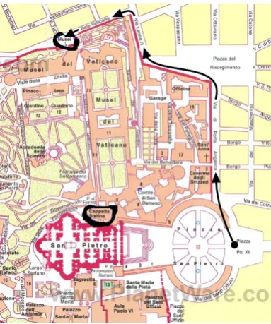
Finally, consider a map for the Sistine Chapel in the Vatican, Figure 8: How to Get to the Sistine Chapel.12This map guides one from Piazza Pio XII,
10Created by U.S. Department of State Geographer, c2013
Google, c2009 Geo-Basis-DE/BKG, DATA SIO, NOAA, U.S. Navy, NGA, GEBCO.
11The place name “Jeju-do” is ambiguous: it may mean
ei-ther theislandor theprovinceof Jeju. The name “Jeju” itself is also ambiguous: it may refer to either thecityor theprovinceof Jeju.
12Except for the paths to the entrance to the Vatican
[image:8.595.70.291.106.238.2]Museums marked by the author, this map is provided by PlanetWare.com with the following note: Use this map
Figure 8: How to Get to the Sistine Chapel
which is just at the entrance to Piazza San Pietro, to the Vatican Museums following the sequence of the arrows going through the roads, namedVia di Porta Angelica, Via Leone IV, andViate Vaticano. There she could enter the museums and all the way to the chapel, namedCapella Sistinain Italian.
6 Concluding Remarks
This paper applies ISO-Space to the annotation of non-textual data such as maps and figures or even some textual data presented in a tabular form be-cause spatial information is very often carried by such data. In annotating such data, one difficulty was how to anchor such basic entities asPLACEand PATHto parts of the data, since pictures and figures, unlike texts, cannot be tokenized. Another difficulty arose from the understanding of various symbols or conventional cues in visual data. A non-location en-tityMOTION ofISO-Space, for instance, is seldom mentioned explicitly, but only expressed implicitly
on your web site - copy and paste the code below: <a href="http://www.planetware.com/map/ vatican-city-map-scv-vat ce.htm"> <img src ="http://www.planetware.com/i/map/SCV /vatican-city-map.jpg" width="1200"
with a little pointed arrow, as in Figure 1 or Fig-ure 8. We have argued that such difficulties can be overcome if different layers of visual data are pre-sented and also if various types of information from those data are combined in a consistent way. We have also proposed two conventional techniques for the treatment of markables in annotation: one is to name relevant elements in non-textual data and an-other is to segment figures in a referable way, for instance, with coordinates. Naming and segmenta-tion are then shown to be providing different layers of annotation, as needs arise.
We have, however, treated these issues simply as technical issues for linguistic purposes only. We have thus avoided discussing any theoretical impli-cations that may go beyond the domain of linguistic annotation, although we have not explicitly demar-cated the line between what is linguistic and what is not. A question still remains whether the an-notation of non-textual data or multimedia is part of linguistic work. For computing purposes, how-ever, more serious questions may be raised. One could ask how non-human agents can annotate such non-textual data for spatial or spatio-temporal infor-mation. Towards answering these questions, more work should be done on multimedia or motion tag-ging, as discussed in Mani and Pustejovsky (2012), and more serious references should be made to some initiatives that exist in GIS(Geographic Information System)-related communities.
Acknowledgements
I own many thanks to Suk-jin Chang, Jae-Woong Choe, Roland Hausser, Hwan-Mook Lee, Ghang Lee, Chongwon Park, and four anonymous review-ers for their very constructive and detailed com-ments that helped improve the paper.
References
Berg, Mark de, Otfried Cheong, Marc van Kreveld and Mark Overmars. 2010. Computational Geometry: Algorithms and Applications, 3rd edition. Springer, Berlin.
Bunt, Harry. 2010. A methodology for designing seman-tic annotation languages exploiting syntacseman-tic-semanseman-tic iso-morphisms. In: A. Fang, N. Ide and J. Webster (eds.)Proceedings of ICGL 2010, the Second
Interna-tional Conference on Global Interoperability for Lan-guage Resources, pp. 29-45. Hong Kong City Univer-sity.
Bunt, Harry. 2011. Introducing abstract syntax + seman-tics in semantic annotation, and its consequences for the annotation of time and events. In E. Lee and A. Yoon (eds.),Recent Trends in Language and Knowl-edge Processing, pp. 157-204. Hankukmunhwasa, Seoul.
Galton, Antony. 2000. Qualitative Spatial Change. Ox-ford University Press, OxOx-ford.
ISO 24612:2012(E) Language resource management -Linguistic annotation framework (LAF), International Organization for Standardizations, Geneva.
ISO 24617-1:2012(E) Language resource management - Semantic annotation framework - Part 1: Time and events (SemAF-Time, ISO-TimeML). International Or-ganization for Standardizations, Geneva.
Lee, Kiyong. 2012. Towards interoperable spatial and temporal annotation schemes.Proceedings of the Joint ISA-7, SRSL-3, and I2MRT Workshop on Semantic An-notation and the Integration and Interoperability of Multimodal Resources and Tools, a satellite workshop (26-27 May 2012) held in conjunction with LREC 2012. Istanbul.
Mani, Inderjeet, and James Pustejovsky. 2012. Inter-preting Motion: Grounded Representations for Spatial Language. Oxford University Press, Oxford.
Pustejovsky, James, Jessica Moszkowics, and Marc Ver-hagen. 2012. The current status of ISO-Space. Pro-ceedings of the Seventh Workshop on Interoperable Se-mantic Annotation (ISA-7), a satellite workshop held in conjunction with LREC 2012. Istanbul.