ISSN 2286-4822 www.euacademic.org
Impact Factor: 3.4546 (UIF) DRJI Value: 5.9 (B+)
Factors affecting the environment and climate
change in Kanshi watershed area, Pakistan and its
impact on local ecosystem
MOHSAN EJAZ
Center for Integrated Mountain Research University of the Punjab, Lahore, Pakistan
Abstract
Keywords: Environmental degradation, River discharge, Agricultural practices, Hazards, Floods, Soil erosion, Sedimentation.
1. INTRODUCTION
Climate change refers to any significant change in measures of climate (such as temperature, precipitation or wind) lasting for an extended period (decades or longer), (United States Environmental Protection Agency) [1]. Climate change is extremely noticeable and varies worldwide in its strength. However, it happens in the perspective of numerous factors, such as land-use, anthropogenic activities, developments and deforestation etc. The process of development has significantly affected the value of ecological landscape variations and social–cultural changes in ecosystems, which has disturbed the human interaction with nature. The focus of this study is to identify the major factors that are affecting the environment and climate in Kanshi river basin and impact of these on the socio-ecological patterns and land-uses in Kanshi watershed area.
In developing countries, widespread land cover change driven by socio-economic development results in pervasive environmental degradation, particularly landscape fragmentation [2]. Forest cover change, for example, due to human activities has resulted in a net carbon flux to the atmosphere [3] [4], which in turn has contributed to global climatic change [5]. It was reported that climate change scenarios are non-linear, highly vulnerable and uncertain. In closed loop, these uncertainties are result of climate change which might be the result of continued land change. Forest conversion into agriculture land is a source of peak flows in water channel which increased the erosion [6].
latitudes, and an increase in the magnitude and intensity of life-threatening precipitation events [8]. Shakir et al. (2010) [9] reported that climate change was resulted as variations in river flows in Pakistan which was the result of uncertain precipitation trends. There studies predicted that water flows in river were decreased by about 2.4% in northern Pakistan. Uncertain precipitation due to climate change can generate high runoff volumes that can erode the soil and result into the sedimentation of facilities such as dams.
Hanif et al. (1990) [10] conducted a research on run-off and sedimentation issue in Kanshi watershed. They reported that there were severe erosion problems in the study area and during monsoon season the Kanshi watershed produced high run-off, resulting high sedimentation rate due to erosion activity which was reduced by watershed restoration program. They also reported that above the Mangla reservoir over-exploitations of watershed lands were adversely affecting the reservoir due to accelerated erosion.
Apart from forest degradation and land conversion, increasing urbanization is of global concern in altering the climatic patterns and environmental degradation. Since urban expansion onto rural lands significantly affects energy flows, biogeochemical cycles, biodiversity and climatic conditions at local and/or regional levels [11]. Urbanization causes substantial reduction of arable lands [12], habitat destruction [13], species extinction [14] and landscape degradation by patch fragmentation and ecological change [2] [15]. All these changes are identified as decisive factors attribute to global change which would negatively impact the humans [16]. Present study is focused on the direct or indirect impacts of environmental degradation and climate change on Kanshi river basin.
2. STUDY AREA
The study area consists of three distinct portions according to general configuration. The first portion consists of Potohar. In the plain of Potohar which includes the whole of Gujar Khan tehsil except a small corner on the east traversed by the hills on the bank of Jhelum and south east portion of the Kahuta tehsil. Second portion consists of Murree, Kotli-Sattian and northern portion of Kahuta. The third portion is Rawalpindi tehsil extending through Kahuta up to the west bank of the Jhelum and down into the Gujar Khan till it reaches the northern border of Jhelum district (Population Census Report 1998). Kanshi watershed is sub-watershed of Mangla watershed which is situated in tehsil Gujjar Khan and tehsil Kahuta of Rawalpindi district. Har, Kurri, Missa, Guliana, Phahna, Gulin streams and some other small streams of Kanshi which after joining Kanshi drain into the Jhelum River at 33°14'54.59"N Latitude and 73°36'24.21"E longitude. Fig. 1 shows the location of Kanshi sub-watershed with reference to Mangla watershed. Kanshi River originates from Kahuta and Gujar khan. It’s the only sub-watershed of Mangla which is situated in Punjab. Gujjar khan and Kahuta are highly erodible regions.
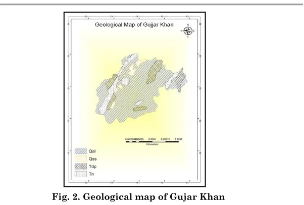
2.1.Geological Setting
Fig. 2. Geological map of Gujar Khan
(a) Surficial Deposits (Qal)
Unconsolidated pebbles, gravels, sand, silt and clay deposits of recent origin occupy stream beds. Old stream deposits are comprised of boulders, cobbles, pebbles of sandstone and limestone, early recent to recent age.
(b) Soan Formation (QSS)
Mainly compact, massive conglomerate with sub-ordinate interbeds of varicolored sandstone, siltstone and clay stone are Soan formation. It is poorly fossiliferous, dis-conformable contact with Dhoke Pathan formation marked by sharp coarsening clastic and by the appearance of massive, deeply packed conglomerate, late Pleistocene to early Pleistocene age.
(c) Dhok Pathan Formation (TDP)
A monotonous cyclic alteration of light grey, gleaming white or reddish brown, thick bedded, calcareous soft, cross bedded sand stone and orange, brown, dull red, calcareous and sandy clay, conglomerate lenses in upper part is observed.
(d) Nagri Formation (TN)
2.2.Climate
Kahuta and Gujar Khan encompass a hot summer and moderate winter. According to census report 1998, average rainfall in these areas is 913 millimeter per annum .The coldest month is January while the mean maximum temperature is 17.7 degree centigrade and minimum 2.6 degree centigrade. From February to May, the temperature rises at the rate of 5.06 degree centigrade per month. The highest temperature is observed in June when the temperature may raise up to 45 degree centigrade. The monsoon rains start in July. Temperature ranges between 5 to 45 degree centigrade and this immense range of temperature is responsible for making the climate healthy and bracing.
3. MATERIALS AND METHODS
Present study is focused on identifying the factors affecting the environment and climate of Kanshi water shed area and their direct or indirect impacts on ecosystem of Kanshi river basin. Mostly social research methods were used including surveys, questionnaire, interviews, and observations by interacting with the local community. However, to digitize the study area maps and to perform the quantitative analysis on the data Arc GIS and Arc hydro software were used. Data about the study area was collected from relevant authorities e.g. study area maps, satellite images, development patterns, hydrological and geological data, soil formations etc. Field visits were also conducted to observe the actual on ground conditions of the study area.
4. ANALYSIS AND DISCUSSION
precipitation, extreme or very low rainfall, temporary drought conditions and river flow patterns and discharge of river.
As per results of surveys and field observations the major factors that have affected the climate of Kanshi river basin include anthropogenic activities, urbanization, development, wrong agricultural practices and deforestation. The present status of the study area suggests significant role of anthropogenic activities in contribution to climate change. According to survey, 85% of local population are in support of the opinion that the change in overall climate is the result of anthropogenic activities.
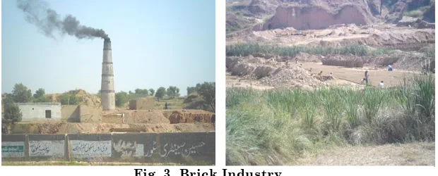
Brick business is most commonly observed in Gujar khan. Travelling from Gujar Khan to onwards Qazian-Jabber and from Guliana to onward Missa Keswal, people are involved brick business to sustain their livelihood. Dozens of brick kilns are present in Qazian, Jabber Guliana and Missa-Keswal. These practices are quite harmful for land, water and air. These kiln are producing tons of smoke and carbon dioxide that is polluting the atmosphere and increasing the greenhouse effect. As the results of this activity, not only air quality is being affected and land is degrading rapidly but it is also affecting the climatic conditions adversely.
Urbanization is another major factor which is mainly responsible for the use of bare land. It is well reported that urban expansion onto rural lands significantly affects energy flows, biogeochemical cycles, biodiversity and climatic conditions at local and/or regional levels. Moreover, urbanization causes substantial reduction of arable lands, habitat destruction, species extinction, the reduction of net primary productivity, and landscape degradation by patch fragmentation and ecological change. Due to no proper controls,
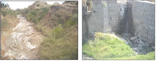
the waste of settlements in the form of sewerage and solids is disposed into channels and cultivating lands which is causing the land and water pollution.
Fig. 4. (a) Chemical deposits in local stream (b) Disposal of waste and sewerage in local Nullah (stream)
In Kanshi river basin, the vegetation cover has significantly decreased as compared to past due to urbanization and infrastructure developments. Urbanization is one of the major causes of flash floods in this area. People are using bare lands for their settlements as the result natural ecosystem sustainability is disturbed and runoff increased causing flash floods in monsoon season. Moreover, deforestation for the purpose of creating agriculture land and economy by cutting and selling the trees has also impacted the green belt of the area. According to survey the major issue related to forest degradation included lack of awareness agriculture, lack of incentives, mismanagement and poverty. Wrong agricultural practices by over consuming the ground water instead of water harvesting and use of various chemicals to increase the crop yield are lowering the water table, polluting the land and water and as a result converting into the barren lands. Water scarcity and polluted soil are also causing the forests degradation and local eco system is being destroyed. Long ago tigers and leopards used to be very common in these forests. These animals have now become more or less extinct. Similarly the many plant species that were previously present have died in the area.
eco-system. All these changes are identified as decisive factors attribute to global climate change, which would negatively impact the humans.
Fig. 5. (a) Embankment erosion (b) Land erosion
Because of uncertain rainfalls due to climate change, the flash floods are common in this area especially in monsoon season. Mostly the geology of study area is soft and consists of surficial deposits, Soan formation, Dhok Pathan formation and Nagri formation. This type of geology supports the erosion activity. Moreover, due to the deforestation and lack of vegetation cover along the banks of channels, these high flow floods cause severe erosion in the area (Fig. 5). These soil erosion by floods not only results in loss of top fertile layer consequently many acres of unproductive land but also accelerates the sedimentation rate in Kanshi river basin. Only Kanshi River contributes more sediment to Mangla dam than that of all tributaries of dam. This climatic variation increased siltation rate has affected and reduced the storage capacity of Mangla dam.
Fig. 6. Discharge of Kanshi River in decade 1990’s and 2000’s
From fig 6, the peak flow for 1990’s is observed in 1992 which was the result of heavy rains in Kanshi catchment. The variations are not uniform in the graph. These values show the uncertainties in rainfall pattern and extreme wet and dry conditions. It can be observed that average discharge during 2001 to 2010 is decreased but the 2010 flow is on its highest value. It represents the abnormal heavy precipitation period of 2010 that also caused flood in region.
5. CONCLUSIONS
destruction. Proper and immediate controls need be applied to minimize the adverse impact of human activities on surround eco-system and environment.
REFERENCES
1. U.S Environmental Protection Agency Basic Terminology. http://www.epa.gov/ climate change/basicinfo.html.
2. Grimm, N. B., Faeth, S. H., Golubiewski, N. E., Redman, C. L., Wu, J., Bai, X., & Briggs, J. M. (2008). Global change and the ecology of cities. Science, 319(5864), 756-760.
3. Houghton, R. A., and D. L. Skole. (1990). Carbon. pp. 393-408. In B. L. Turner, W. C. Clark, R. W. Kates, J. F. Richards, J. T. Mathews, and W. B. Meyer (eds.), The Earth as Transformed by Human Action. Cambridge University Press, Cambridge, U.K. 4. Alves, D. S., & L SKOLE, D. (1996). Characterizing land cover
dynamics using multi-temporal imagery. International Journal of Remote Sensing, 17(4), 835-839.
5. Houghton, Richard & L. Hackler, J & Lawrence, Kira. (1999). The U.S. Carbon Budget: Contributions from Land-Use Change. Science (New York, N.Y.). 285. 574-8. 10.1126/science.285.5427.574.
6. Mango, L. M., A. M. Melesse, M. E. McClain, D. Gann and S. G. Setegn., (2011). Land use and climate change impacts on the hydrology of the upper Mara River Basin, Kenya: results of a modeling study to support better resource management.
7. Inter-governmental Panel on Climate Change (IPCC). 2014. Climate Change 2014: Impacts, Adaptation, and Vulnerability. IPCC Working Group II Contribution to AR5. http://ipccwg2.gov/AR5/
8. Zhuang, D., J. Liu and M. Liu, (1999). Research Activities on Land-use/Land-cover Change in the Past Ten Years in China Using Space Technology.
9. Shakir, A. S., H. Rehman, and S. Ehsan (2010). Climate change impact on river flows of Chitral watershed. Civil Engineering Department, University of Engineering and Technology Lahore. 10. Hanif, M. and F. Subhan, (1990). Watershed restoration reduces
Pakistan's subtropical scrub zone. Pakistan Forest Institute, Peshawar, Pakistan
11. M Green, Douglas & G Baker, Micheal. (2003). Urbanization impacts on habitat and bird communities in a Sonoran desert ecosystem. Landscape and Urban Planning. 63. 225-239.
12. Lopez, E., Bocco, G., Mendoza, M., & Duhau, E. (2001). Predicting land cover and land use change in the urban fringe a case in Morelia City, Mexico. Landscape and Urban Planning, 55(4), 271– 285.
13. Alphan, H. (2003). Land use change and urbanization in Adana, Turkey. Land Degradation and Development, 14(6), 575–586. 14. McKinney, M. L. (2006). Urbanization as a major cause of biotic
homogenization. Biological conservation, 127(3), 247-260.
15. Dewan, A. M., Yamaguchi, Y., & Rahman, M. Z. (2012). Dynamics of land use/cover changes and the analysis of landscape fragmentation in Dhaka Metropolitan, Bangladesh. GeoJournal, 77 (3), 315-330.