Peripato Telematikos: Walking, Cartography and Software Art Submission for the degree: Doctor of Philosophy
School of Communication and the Arts
Faculty of Arts, Education, and Human Development Victoria University
Abstract
Peripato Telematikos began with walking as a means to explore and investigate the places and spaces we inhabit and our relationships with them. The research asked how can peripatetic art practices inform the methodologies used by individuals to (re)present their environs and what media art practices would be suitable to support these (re)presentations? The project sought to provide ways for audiences to engage with these walks in real time through their
documentation by mobile phones. In order for this to happen I created a platform for the reception and viewing of the walks as they occurred. One interpretation of what was created by the documentation of the walks was what I termed a
‘subjective mapping’ of place. As a result, the final viewing interface was constructed with the intent that it would support the creation and viewing of subjective mappings.
In order to understand how the different elements of walking, documentation and interface could be combined I conducted a number of planned, staged walks with groups and individuals using strategies discovered from the research into
peripatetic and media art practices. This developed my understanding of how mobile phones with media capture and transmission capabilities, could be used to document the walks in real time. Media collected by the mobile phones was sent to an internet application prototype as it was collected so that the audience could engage with the walkers as the events took place. The use of mobile phones facilitated the live documentation of the walks and the infrastructure created was able to provide the technology to deliver sms and mms messages from the walkers’ phone to the viewing platform. An experimental interface prototype was developed to support the spatial organisation of mapping the content and has been successfully used in many workshops, staged walks and has been presented at conferences.
This process enabled the participants to discover something new about their environs through walking, documenting, and mapping the walks. Individually, the walks contributed to an understanding of autobiography in and of a particular place.
iii I, Greg Giannis, declare that the PhD thesis entitled 'Peripato Telematikos:
Walking, Cartography and Software Art', is no more than 30,000 words in length including quotes and exclusive of bibliography, references and endnotes. This thesis contains no material that has been submitted previously, in whole or in part, for the award of any other academic degree or diploma. Except where otherwise indicated, this thesis is my own work.
Acknowledgments
Sincere thanks to my supervisors, Professor Mark Minchinton, Dr. Judith Walton and Dr. Marsha Berry, my family for their support and patience and my
colleagues for their assistance. Sincere thanks to Dr. John Hannon and Dr.
Bronwyn Cran for their assistance with the exegesis, and Dr. Stefan Schutt for his proof reading and feedback.
Many thanks to those that assisted with and participated in the workshops, including Jeanette and David Hutchinson, Pia Armitage, the staff at Ur Studio, Adelaide, and the Apple University Consortium.
Thanks to the ISEA 2008 and 2011 selection committees in Singapore and
Istanbul respectively, for the opportunity to present the work at the conferences, and to the galleries that have exhibited the work:
Umbrella Gallery, Townsville, Adelaide Fringe Festival, Adelaide,
The Australian Network for Art and Technology for touring the work to regional galleries around Australia from 2008 to 2010.
Museum of Image and Sound, Sao Paulo (2009) and Rio de Janeiro (2010), Brazil
The Captain, Aphrodite and Theodore for their invaluable assistance and care in Greece.
Greg Giannis
v Table of Contents
Abstract ... ii
Table of Contents ... v
Table of Figures ... vi
Introduction ... 7
Peripatetic Art Practices ... 13
Peripatetic Art and Mapping ... 18
Cartography ... 31
Concerns of Cartographic Discipline ... 37
The Walks ... 42
Reservoir ... 43
Greece ... 51
Collective Walks ... 63
Software ... 80
Software Development ... 80
Software Art ... 81
Interface ... 93
Critical Evaluation of the Interface. ... 102
Interface Research ... 107
Conclusion ... 109
Appendix 1 Logging On ... 117
Appendix 2 Navigating The Interface ... 119
Appendix 3 Townsville Workshop Review ... 120
Appendix 4 VITTA Letter ... 124
Appendix 5 The History Of Agiassos ... 126
Appendix 6 ZUI Research ... 127
Appendix 7 Interface Research ... 136
Appendix 8 Usabilty Tests ... 143
Appendix 9 The Software/Hardware System ... 154
Table of Figures
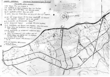
Figure 1 - Pigadakia Mud Map ... 52
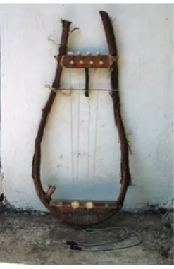
Figure 2 - Constructed Harp ... 54
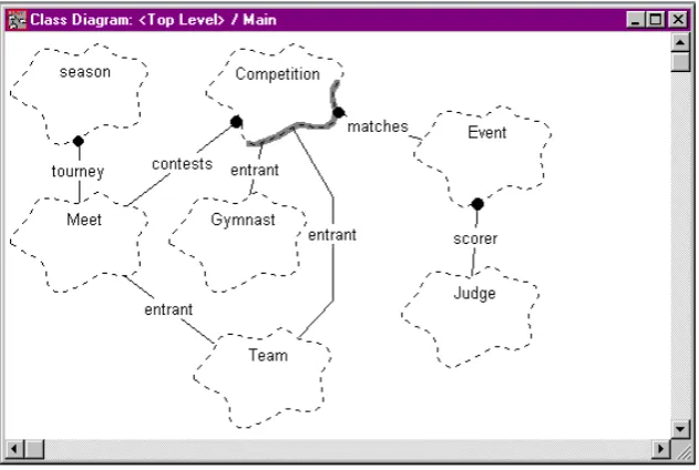
Figure 3 - Class Diagram ... 91
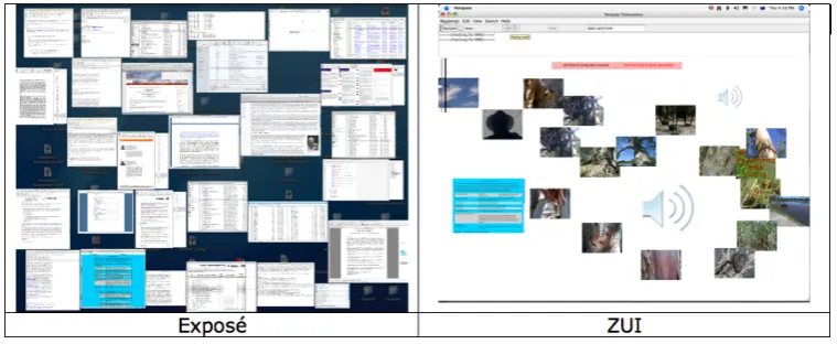
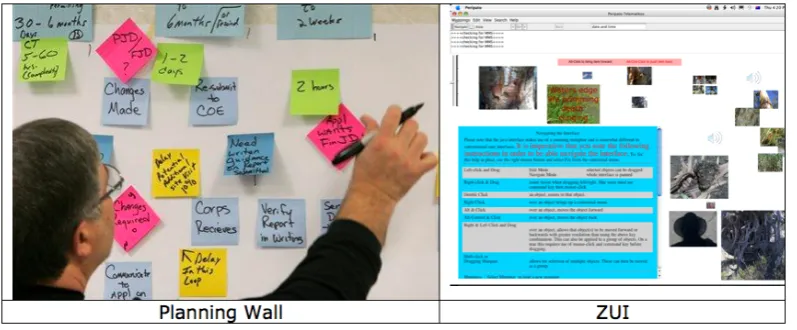
Figure 4 - Exposé and ZUI ... 95
Figure 5 - Planning Wall and ZUI ... 97
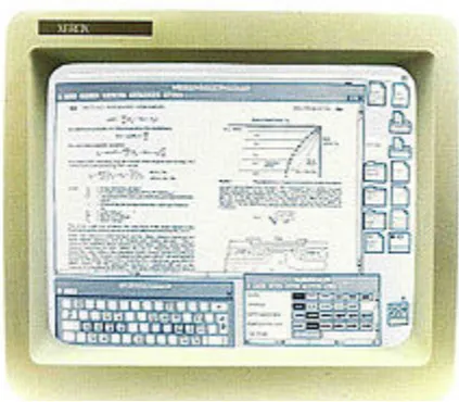
Figure 6 - The Xerox Star Workstation - the first GUI. ... 137
Figure 7 - XanaduSpace with camera rotated 90 degrees ... 140
Introduction
I am a Greek-Australian artist who has a diverse practice, experimenting with many mediums and in many contexts. Past projects include photographic based work, interactive installations, public projections, net.art, participatory works, collaborations with living creatures (e.g. snails) and generative art. I have a background in software design engineering, but moved away from this in the mid 1990s to pursue my interest in art. Since then, I have exhibited and presented papers at many media art exhibitions and several festivals in Australia and overseas. A thread that recurs with my work is the utilisation of
telecommunications systems and software writing to engage the public in
participatory works. This research project applies artistic practice to the research and development of a multi-disciplinary telematic work to explore walking-as-art in order to create representations of place, or subjective mappings, through the integration of the mediums of cartography and the mapping of walks, software design, and media art. The research has built upon past works by combining and syncretising in order to create a work that spans disciplines and practices.
Peripato Telematikos, the title of this work, is a play on the words ‘peripatetic’ and ‘telematic’. Peripato is the Modern Greek term for a ritual evening stroll. These walks were very strictly timed and regulated, and provided the only opportunity for some (especially young) people to socialise, or be in the wider world. Peripatetic has been in English since the Middle Ages. It denotes walking to and fro and connotes travelling or working (in) place-to-place, and, when
capitalised, refers to the philosophy or teaching of Aristotle (OED). Aristotle aside, peripato seemed an appropriate term for a work that engages the world through staged walks devised by a second-generation Greek-Australian.
In this project, I sought to explore spaces through individual and collective walking. But a walking that would result in a subversive mapping. A mapping rendered from the ground up; from the embodied experiences of those that traversed the spaces represented, a means of knowing the world by being in it.
expense. I often don’t know how to get from A to B if I have travelled that route as a passenger. I am usually too busy looking at the in-between, gazing out the window, trying to absorb what flies past. I am accused of having my head in the clouds, of not being attentive to the route. But I would argue that I am being attentive, not to the final destination and how to get there, but to all that is encountered on the route. Choosing walking as the medium for art /performance allows me to experience the journey and all that is encountered along the way.
From Highmore's perspective, walking allows the individual to experience the world at a rhythm which digital technology denies with its constant interruptions and breakdowns (Lavery 2009, p. 47).
The pace of walking (as opposed to cycling or driving) allows a greater
engagement with the route or path and all that it entails. It allows for pauses, giving time for the body to register an internal, visceral sensation of that moving. As Massumi says ‘When I think of my body and ask what it does to earn that name, two things stand out. It moves. It feels. In fact, it does both at the same time. It moves as it feels, and it feels itself moving’ (Massumi 2002, p. ix). We come to know space bodily as well as through the traditional senses of sight, smell, sound and touch. The grade of the land, the texture of the path, the putrid smells of industry or intoxicating home cooking or the crisp air against our skin are all present when walking.
Walking alongside a child adds another dimension to this experience. Walks with my daughter were always slow, and full of unexpected twists and turns. They were local: to the playground, the lake, the shops or often with no particular destination in mind. Everything that caught her eye had to be examined: flowers, rubbish, insects or anything else that lay in her path. Spencer had similar
experiences with his toddler, and reflects, ‘what occurs to the adult walking alongside this blossoming creature is (phenomenologically speaking) a mind-blowing experience’ (Spencer 2004, p. 26). I noticed things I would never have stopped for. Time became irrelevant, we were in the here and now, whilst the world raced uncontrollably around us. I learnt many things from these
Walking was conducted with groups of participants to explore the possibility that a multiplicity of viewpoints can contribute to a richer understanding of place. Strategies were employed to give voice to the participants, and to encourage the breaking of habitual behaviour by leading the walkers into unfamiliar territory. The participants in the collective walks were given a voice in the workshops by not imposing any agenda of my own.
I conducted many walks, reversing the situation described above so that rather than leading a collective through the walking, I became the sole walker. Strong personal threads of reference run through this thesis. They are not to do with autobiographical chronology, but rather with the language and geography of the spaces investigated through walking and the reminiscences they evoked. This is akin to Walter Benjamin’s notion of memoirs. Benjamin differentiates between reminiscence and autobiography.
Autobiography has to do with time, whereas memoirs focus on space (places, fragments) and depth rather than continuity of experience (Benjamin, W. 1979, p. 316).
My solo walks were conducted primarily in two locations: around my home in the suburb of Reservoir, and around my ancestral home, the island of Lesvos, Greece. I endeavoured to walk routes that were not predefined, to not follow ‘tracings’, or traverse paths of extant knowledge. In Reservoir, this led me to follow routes of hidden urban waterways, waterways that have been subsumed by the urban infrastructure and rendered invisible in most instances. In Lesvos, the walking became connected to notions of pilgrimage and life. I walked routes that would have been traversed by my mother’s ancestors, and the hinterlands of my father’s village. I became immersed in the rhythms and rituals of the island people, and walked daily.
The word telematic1, derived from the French telematique, simply refers to a
conjunction of computers and telecommunications systems. The walks in this project were documented in real-time using mobile phones, which transmit content recorded by the walker to a system comprising a networked computer server. The walks are documented and broadcast in this way to give an audience a glimpse of this experience, in order to capture this ‘authentic moment’
1 Telematics is the English language version of the French word telematique -- coined by Simon Nora and Alain
(Abramovic et al., 1979, p. 15), a term used by Marina Abramovic in relation to the moment that an image is taken during the walks conducted by Richard Long and Hamish Fulton. This moment is broadcast in real time so that it can be witnessed as it happens and not after the event, as is usually the case with many peripatetic art works.
A major research question was: is it possible for the walker(s) to engage a geographically dispersed audience during the walks? Might it be possible to capture the ‘authentic moment’ using a medium that allows instant distribution from the actual location of the event? Is it possible for a remote audience to witness the ‘authentic moment’? The research asked what media art practices would be suitable to support these aims? This increased my understanding of issues relating to the use of mobile phones; for example, the type of
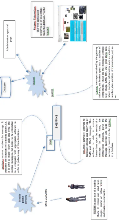
infrastructure, hardware and software needed to enable a walker to transmit media using a mobile phone whilst walking. This led to the development of an SMS/MMS gateway and the ancillary hardware and software required to implement this functionality. This required the development of a custom
software/hardware system, which facilitates the transmission, storage and display of the material generated from the walks. I created a unique on-line context2 and artwork that subverts static cartographic conventions through specialised
software integrated with the required hardware. This custom software and hardware allows for the real-time collection of media contributions/content through the use of SMS and MMS capabilities of mobile phones. An Internet-enabled application was created through which an audience could view this content as it arrived, allowing for a real-time engagement with the walks from anywhere in the world.
The interface is an integral component, written specifically for this project that makes use of an experimental Zooming User Interface (ZUI) paradigm as this was deemed best for viewing mappings. ZUIs are interfaces that tap into man’s inherent spatial organisation abilities, and hence, well suited to mapping
applications.
This interface of the website facilitates the viewing of the subjective mappings, and allows for interactive manipulation of that content, making the subjective mappings mutable for creators of the mappings. A custom written Java
2
application is downloaded to view the works. This application can be downloaded from the site http://www.peripato.net
The intent with the mappings is to subvert static cartographic conventions. Mappings that create a (re)presentation from the view point of ground level are responding to and reacting against the controlling view from above, which has been facilitated by the striation of the earth's surface using a grid of lines which is encapsulated in the contemporary world by the GPS system, referred to by some theorists as the 'Imperial grid' (Holmes 2004). The uncritical adoption of this system has been seen as a return to Cartesianism or the ‘Cartesian tradition’, a return to the controlling view from above. This posed the question: how can we free ourselves from the imperial grid?
As an artist working with software I was interested in the discussions and
theoretical concerns emerging relating to software literacy and subjectivity. This led to the research question: how do we get around the domination of such powerful corporations that determine what and how we do with much computer software? How do we battle the power vested in software? I proposed that one strategy is to make use of open-source software in the development of the software and outline the reasoning behind this decision in the main body of the exegesis.
I investigated peripatetic art practices to inform the methodologies used by individuals and collectives to (re)present their spaces. This included research into media art practices (with a focus on the use of the mobile phone) in order to gain an understanding of related works and to inform this project’s desired aims relating to the use of mobile phones; for example, does the ubiquity of mobile phones facilitate participation? Do the limitations of mobile communications devices hinder or enhance these processes?
This project relies on walking to engage with the world. It has been revealed through experience that this walking has the ability to prompt reminiscent
behaviour. The literature and experiences of others also supports this contention. As author, Rebecca Solnit, who has written extensively about walking, states:
Walking ... is the intentional act closest to the unwilled rhythms of the body, to breathing and the beating of the heart . . . Walking; ideally, is a state in which the mind, the body, and the world are aligned, as though they were three characters finally in conversation together, three notes suddenly making a chord (Solnit 2001, p. 5).
The three major aspects of this project: walking as art, cartography and software are related through their ability to produce a particular type of knowledge. A knowledge that can be highly subjective incorporating: ‘atmospheres, emotions, reflections and beliefs … as well as intellects, rationales and ideologies’ (Anderson 2004, p. 260). Anderson continues to argue that walking is part of a wider post-modern project that endeavours to challenge knowledge that is generated from the outside, and seeks to find ways to create more equitable and collaborative forms of knowledge, as this project does when engaging a collective.
Peripatetic Art Practices
Wandering is the condition of contemporary art(Bordo 1996, p. 202).
I have a strong childhood memory of walking alongside my father. I watched his feet take great, confident strides while I struggled to keep up, alternating
between a fast walk and a slow jog. I knew that one day, I too would be able to take great strides.
Peripato Telematikos looks at walking as an art form and in order to situate the project within an historical, conceptual frame, I will discuss related practices, artists, art movements and theories.
That going for a walk is considered art is not an issue [3…(after three decades of
dematerialisation)…we are well used to the idea that art can simply be a walk] . Long (cited in Spencer 2004, p. iv).
Spencer has summarised the extensive history of walking as art in his thesis ‘Hermes's Gift’ (Spencer 2004, p. iv). Here I focus on a few of the important ideas raised by Spencer and provide some examples pertinent to my project. In
investigating the history of walking and art we can look as far back as Baudelaire’s flâneur (one who strolls) and his exploration of the urban
environment of Paris in the 1850s. Baudelaire conceptualised the flâneur as the artist of the times, who needed to immerse himself [sic] in the metropolis and become in Baudelaire’s phrase ‘a botanist of the sidewalk’ (Tiessen 2007). Baudelaire felt that traditional art was no longer adequate for the new dynamic complications of modern life bought about by the social and economic changes of industrialisation (Baudelaire 1964). So was born the relationship between the pedestrian activity of walking and art. Walter Benjamin, a German-Jewish literary critic, philosopher, social critic, translator, radio broadcaster and essayist
5 Walking about; itinerant; nomadic. From http://en.wiktionary.org/wiki/peripatetic accessed 25/03/2009
subsequently adopted this concept, and his unfinished Arcades Project consists of an enormous collection of writings on city life in Paris and the culture of ‘flânerie’:
[It] was not the great men and celebrated events of traditional historiography but rather the ‘refuse’ and ‘detritus’ of history, the half-concealed, variegated traces of the daily life of ‘the collective’, that was to be the object of study, and with the aid of methods more akin – above all in their dependence on chance ... to the methods of the nineteenth-century rag picker, than to those of the modern historian (Eiland and McLaughlin 1999, p. ix).
Other ‘artistic movements in the 20th century, from Dada and the Surrealists through to Fluxus and the Situationists have explored similar modes of distracted attention in traversing the city’ (Lucas 2004). Most notably, the Situationists, with their work surrounding the use of urban space, ‘from seemingly inconsequential rambles around European cities to relatively rigorous and well documented experimental activity’ (Bonnet 1992, p. 77), developed an agenda extending beyond art alone and have had considerable influence on many contemporary works that examine urban space in some way.
There have been a number of recent conferences (e.g. Walking as Knowing as Making: A Peripatetic Investigation of Place, Conflux) focussing specifically on psychogeography, one of the key concepts of the Situationist manifesto, and a number of artists using the Situationist strategy of more-or-less unplanned walks (or, in Situationist terms, ‘dérives’).
Walk Ways (a traveling group exhibition held in various locations in the U.S. 2002-2004) brings together a selection of works by a diverse group of artists who explore the theme of walking as an action and/or as a metaphor (Frankel 2002).
Many artists have used walking strategies in different environments and forms: sculpture, minimalism, land art, and performance art to name a few. For
example, Careri, author of Walkscapes: Walking as an Aesthetic Practice reports:
practice of walking begins to be transformed into a true autonomous art form (Careri et al 2002, p. 119).
Tony Smith, and many of his contemporaries for example Carl Andre and Richard Long adopted walking as part of their practice, challenging the existing attitudes to sculpture and Minimalism. Their work was a ‘passage from the minimal object to the objectless experience’ (Careri 2002, p. 122), and was seen as a pivotal moment in twentieth century art. Although the dissolution of the ‘object’ was a primary concern of many artists inspired by Tony Smith, for many it required further resolution. Richard Long, a British walking artist, produces ephemeral ‘sculptures’ often from objects found on the walks, whereas Hamish Fulton, another British walking artist, feels that ‘the only thing we should leave are footprints’ Fulton (cited in Careri et al., 2002, p. 145). Long’s A Line Made by Walking (1967) was a seminal work and his practice is discussed throughout this chapter. Many recent walking performances embody this notion of the minimal object for example, the artist He Yun-Chang in his work Touring Round Great Britain with a Rock, ‘… casually selected a rock from a beach on the coast of Northumberland in northeast England, and carried it around the island of Great Britain in a counter clockwise direction, eventually returning it to the exact location from where it was taken’ (Hood 2008).
In contemporary debates about the ethics of public art and ‘social engagement’ (i.e. what public art should be seen to do and not do ‘for’ its audience), walking-as-art has been proposed as a radical method of reconceptualizing the way in which images in and of public space are produced (Phillips 2005, p. 508).
However as performance artist Marina Abramovic comments:
If you talk with Hamish Fulton or Richard Long, the most important part of their work is their walk which nobody witnesses. What they deliver has nothing to do with that process. Particularly not if you take a photograph during the walk. The act of taking the photograph would be the most authentic moment (Abramovic et al., 1979, p. 15).
This raises the question, might it be possible to capture this ‘authentic moment’ using a medium that allows instant distribution from the actual location of the event? Can the ‘most important’ part of the walk be witnessed or
Peripato Telematikos utilises mobile devices for the specific purpose of
documenting the staged walks and thereby facilitating the creation of subjective mappings in real-time and capturing this ‘authentic moment’. The mappings are mostly images, captured and transmitted by/as MMS. However the network operators restrict MMS message size to 100KB meaning that the final images must be compressed considerably in order to be sent. Working with this limitation requires an understanding of the repercussions of digital image compression. Any fine detail in a complex image can be lost. Images with less visual information are better able to retain their integrity, after being processed through the MMS
constraints.4
Since the introduction of mobile phones, media artists in particular have been experimenting with this new medium in a myriad of ways. For example the UK group, Blast Theory, has made extensive use of mobile devices in works such as Day of the Figurines (2006) (Theory 2006b).
Peripato Telematikos uses mobile devices in order for participants to map their environs and to allow audiences to engage in real time with the walking
performances.
Artists are responding to the technical possibilities of location-aware, networked media by asking what can be experienced now that could not be experienced before (Hemment 2004).
In the past, the public's access to walking-as-art events has been limited to the documentation or other by-products exhibited after the event. Mobile devices have the potential to broadcast content during the event allowing an audience to witness something of the event while it is taking place. This project realises that potential of live broadcasting of media through the creation of a custom system that is discussed in greater detail in the Software section.
A limitation of this system is that all communications devices are dependent on the network operators' provision of service. Within these restrictions mobile communication devices have the ability to capture media (images, text, video and
4 (To clarify what is meant by a complex image, a colour field image such as a Rothko painting has less visual
sound), and transmit that media almost instantaneously, enabling their real-time broadcast. Some projects explore these limitations, using the restrictions in creative, experimental ways. For example, Andrew Wilson, an English poet, has explored SMS, which has a restriction of 160 characters, for creating poetry; the results have been published in print and made available for viewing on a
dedicated website (Wilson, 2007). More recently, the Darebin Council Arts Project Coordinator initiated a writing competition, Northern Notes Writers Festival 2008 - SHRT, shrts an SMS Writing Competition that required entries to be submitted by SMS (Forward 2008). These restrictions facilitate new and experimental approaches to existing media forms.
An Australian work that utilised mobile devices to document a walk and engage a remote audience is Void: Kellerberrin Walking (Minchinton 2003) conducted over a period of approximately six weeks in 2003, by Australian artist and academic Mark Minchinton. This performance walk addressed many issues, including Minchinton’s identity and cultural heritage, and involved the use of a mobile device to communicate daily texts, images and GPS readings to the
audience/readers through a web site.
Further examples of artists who have used walking as an art form are Domenico de Clario, an Australian artist (breathing for Biagio walking) and the artists that participated in the Walk – NETS Victoria Exhibition (Peter Corbett, Vicki Couzens, Nicky Hepburn, Brian Laurence, Jan Learmonth, Carmel Wallace, Ilka White, John Wolseley) (Copley 2008).
De Clario walked in the footsteps of an Italian migrant named Biagio, who, after arriving in Perth aboard the same ship that Domenico and his famiy arrived in, set out to walk the remaining distance to Melbourne. Biagio died later outside of Kalgoorlie (de Clario et al., 2007, p. 107).
For the Walk – NETS event, a group of artists were invited to undertake a 250km walk along a section of the western Victorian coastline, known as the Great South West Walk, and produce works in response to this experience:
Peripatetic Art and Mapping
A walk is just one more layer, a mark, laid upon the thousands of other layers of human and geographic history on the surface of the land. Maps help to show this (Long 1980, p. 564).
Artists engaged in walking produce many different and varied outcomes from their walks. One outcome that informs this project is the creation of mappings. According to (Dignazio 2009) this has its origins in the Situationists International (SI) movement previously discussed:
The key contribution from the SI, in relation to cartography, politics, and art, is that they set the stage for 'mapping’ as an activity that was 'performed' through the individual human body in action in public spaces such as streets, parks, and plazas. Not only were artists taking on the role of mapmaker, but they were also taking on the roles of the surveyor, the photogrammetrist, and the data collectors, albeit in iconoclastic, idiosyncratic ways (Dignazio 2009, p. 196).
Following on from the SI, in the late 1960s and 1970s many artists, for whom other forms of expression had reached their limits, became interested in mapping as an art practice. These conceptual artists adopted a less political relationship than the Situationists and ‘focused on the idea of an artwork, on theoretical methodologies of documentation, on site and on performance. These concerns directed their engagement with cartography further towards the processes of mapping’ (Cosgrove 2011, p. 272).
Artists have continued to sustain a critical conversation with cartography to the present day. Many site-specific and performance art works ’map out’ spaces in urban locations, and utilize the interactions between people and space (e.g. Lavery 2009). Contemporary art continues to engage with cartographical images and practice as can be evidenced by a series of major exhibitions in the 1990s and later5.
Many of the artists that walk create mappings as a by-product of their walks. This project uses walking as a means to create a (re)presentation of place which I
have chosen to call subjective mappings. As an artist working with mappings, I have investigated related practices to situate this project. There is a great deal of activity at the intersection of art and mapping, as evidenced by the many texts that survey this field (Harmon & Clemans 2009, Dignazio 2009).
Artists are harking back to the premodern, subjective map that ‘concentrated on geographical meanings’ and offered ‘as full an impression as possible of the lived texture of the local landscape’ (Lippard 1997, p. 81).
Jameson concludes that ‘the political form of postmodernism, if there is any, will have as its vocation the invention and projection of a global cognitive mapping, on a social as well as a spatial scale.’
[…]
There would be virtually no end to a list of every artist, literary critic, critical theorist, art historian, sociologist, or philosopher who globally or locally ‘maps out’ the contemporary cultural landscape (Bosteels 1996, p. 110).
Many performative, activist cartographic practices that have succeeded the SI have multiple influences, and have often been realised without knowledge of the movement. Nevertheless, these practices are related conceptually to the original aims of the SI about the individual or collective body encountering social and political space. These practices concern not only urban space, but also suburban, rural, and uninhabited spaces (Dignazio 2009, pp. 196-199). There are many aspects and trajectories to these works. For example, mapping the radically specific is one such prominent practice which involves mapping the small, hyperpersonal or the overlooked facets of the environment.
Richard Long’s art practice (late-1960s to present), for example, consists of solitary, multiday walks in locations around the world. He considers the walks ‘sculptures’ and documents them via short texts, photographs, and gallery installations using natural materials that measure the individual’s temporal presence up against a vast landscape (Dignazio 2009, pp. 196).
Utilising the global positioning system (GPS) receivers, Teri Rueb’s Choreography of Everyday Movement (2001), maps the everyday activities of dancers. The dancers carry the devices with them in the course of their daily activities,
to map a single city block in New York City (One Block Radius by Glowlab, 2004), a map of pumpkins on porches in the neighborhood of Boylan Heights, NC
(Boylan Heights pumpkin map by Denis Wood, 1982), and a map of silent places in London (Silent London, Simon Elvins, 2005).
Another trajectory of contemporary mapping within art projects is the category of experimental geography. These projects usually take the form of tools that enable particular activities. For example, iSee (2001–present) is a web-based software application created by the Institute for Applied Autonomy, an organisation that provides technologies which extend the autonomy of human activists. iSee
facilitates the path of least surveillance through New York City. Users would enter the start and end points of their journey through Manhattan and the application would generate a map that would allow the user to get to their destination via a route that would expose the traveller to the fewest number of surveillance cameras.
The availability of free mapping tools provided by companies such as Google have faciliated many artists, community groups, and activists to create collectively authored maps (Dignazio 2009, pp. 196-199). This intense activity in ‘locative’6 works and experimentation with mobile-networked media is evidenced by the fact that it has been the theme of major recent media arts conferences (ISEA 2004).
[T]he locative project is in a condition of emergence, an embryonic state in which everything is still up for grabs, a zone of consistency yet to emerge. As an emergent practice locative art - like locative media generally - is simultaneously opening up new ways of engaging in the world and mapping its own domain. This resonates with Deleuze’s and Guattari’s sense of territory, in which there is a blurring of the distinction between real estate and intellectual property, between the mapping of physical space and the production of an artistic or cultural milieu: the territory is constituted by the signature or expressive mark, both in the sense that birds use song to map their domain and that the artist creates a new way of seeing and occupying the world (Hemment 2004).
One interesting example of Situationist-like interventions making use of mobile networked media is the Umbrella.Net project (2004), which ‘uses ad-hoc
networking as a means to connect people who share the same physical space and
6 locative – location-aware, networked media
- t
he term is commonly used to refer to many of these locationwho might engage in similar, yet individual activities’ (Brucker-Cohen and Moriwaki 2005). The creative activity in this field is intense; a great variety of projects have emerged, many tackling issues of urban space and community. Many artists have:
…taken as their focus the idea of connecting people to people or people to information but the really unique feature of mobile wireless networks, the thing they can do that fixed networks cannot, is that they can enable more meaningful connections between people and places – they promise the end of ‘the end of geography’. There is little doubt that the connection of people to the places that they live and work is integral to their sense of belonging and community
(Bresnihan and Doyle 2004).
Similar to the early claims made for the Internet, mobile networks are also being seen as promising the end of geography. This comes as no surprise, as both systems make use of global communications networks that facilitate this dissolution of geography. But the two systems differ in one substantial way: mobile networks overcome some of the limitations of the fixed Internet network. In particular, they have the ability to extend the electronic networks into public spaces, so that engaging with the virtual community of the Internet does not require isolation from the immediate physical communities of the real world. Furthermore, these services can be provided whilst the user is on the move and not tethered to a computer terminal.
Related to this one of the defining claims of locative arts is the ability to raise peoples’ awareness of and intimacy with their local environs, which is being seen as a problem of modern urban society and contributing to a loss of community and civil life. As a result many locative projects attempt to address this through staged interventions:
These new media not so much maintain our connection with a lost place through particulars but they bring the lost place into co-existence with the present. More importantly, they create experiences that defy traditional notions of past, present, or future, and instead embrace the possibility of being in more than one place at the same time or the possibility of different places being experienced in one location (Iverson 2008).
‘time–space compression’ – that technology closes the gap of both space and time through its capacity to transcend the limitations of material communication and bodies (Boler 2007).
Through its ability to connect instantaneously to another place, our notions of geography are transformed, or as proponents of the Internet (somewhat breathlessly) hailed, we have reached ‘the end of geography’ (Rheingold; as a caveat, see the discussion of padded lamp posts below). We can be in one place physically, but at the same time engage with another distant location.
Furthermore, time is distorted, as we are able to communicate instantaneously with others in any time zone. As mentioned previously, similar claims were made in relation to the Internet, and understandably so, as it is the communication systems underlying both technologies that facilitate these experiences. In many regards they are able to provide the same services.
One of the defining claims of locative arts is the ability to raise people’s awareness of and intimacy with their local environs. This claim has also been made for many walking projects. As Hemment points out:
If a precursor to locative media were to be identified within the art world it might be Richard Long, who creates his art by walking through a landscape, annotating the physical environment he encounters with stones or other ambient materials, and documenting augmented space that results in photographs that provide an esoteric other to the objectifying gaze of cartography or satellite photography (Hemment 2004).
Many locative projects attempt to address this through staged interventions. But despite this potential, in some cases the technology can work against these aims. At the Coding Cultures conference (Sydney 2007) I talked with Giles Lane, one of the founders of Proboscis and Urban Tapestries. He described what he considered to be a major conceptual flaw of many projects using mobile phones for
was limited. In subsequent years they made use of very simple technologies, namely SMS.
Media art practices aside, in the everyday world we can witness another related phenomenon that works against engagement with place. How accustomed have we become to the sight of individuals totally lost in the use of their mobile
devices? Oblivious to their surrounds, some are actually injuring themselves! In a rather farcical response to this, in London’s Brick Lane padding has been placed around street poles to protect pedestrians immersed in their portable media from hurting themselves:
Britain's first 'Safe Text' street has been created complete with padded lamp posts to protect millions of mobile phone users from getting hurt in street accidents while walking and texting.
Around one in ten careless Brits has suffered a ‘walk 'n text’ street injury in the past year through collisions with lampposts, bins and other pedestrians.
The 6.6million accidents have caused injuries ranging from mild knocks and embarrassing cuts and bruises through to broken noses, cheekbones and even a fractured skull.
Almost two thirds - 62 per cent - of Brits concentrate so hard while texting that they lose their peripheral vision, researchers found (The Daily Mail 4 March 2008).
This distancing distraction has not gone unnoticed by cultural commentators:
There has been criticism of new media technologies implementing a distancing from our own locations, preventing participation in our local community, isolating us from our surroundings, leading us to ignore our own environment when one is able to access new environments in new spaces. Virilio warns against the loss of geography, arguing that as ‘Space is being continuously devalued’ in an age defined by speed the departure and the destination are now one in the same. ‘With the instantaneous communications media, arrival supplants departure: without necessarily leaving, everything “arrives”. The sedentary voyeur is in a constant state of mediated reception leading to the ‘Growing imbalance between direct and indirect information’ (Ota 2008, pp. 361-362).
This issue of ‘distraction’ is directly related to usability. The ‘[g]rowing imbalance between direct and indirect information’ is strongly related to usability which is a concern with many forms of new technology:
international standard, ISO 9241-11, provides guidance on usability and defines it as: The extent to which a product can be used by specified users to achieve specified goals with effectiveness, efficiency and satisfaction in a specified context of use (UsabilityNet 2006).
The more complex a device is to use, the more it distracts our attention from our immediate surroundings, negating the promise of a greater awareness of and intimacy with our local environs.
The ubiquity of mobile communication devices further motivated their use in this project. Mobile communications devices have seen an unprecedented uptake, extending their reach into many sections of society. It has become by far the most ubiquitous form of electronic communication in the world, reaching many whom in the past may have been excluded from access to such technologies. This penetration has prompted innovative commercial and artistic applications of this medium. This availability and ubiquity increases the potential for public
participation in events that solicit involvement through such devices. For instance, Blast Theory:
draws upon the near ubiquity of handheld electronic devices in many developed countries. Blast Theory are fascinated by the penetration of the mobile phone into the hands of poorer users, rural users, teenagers and other demographics usually excluded from new technologies.
Some research has suggested that there is a higher usage of mobile phones among the homeless than among the general population (Theory 2006a).
Blast Theory has staged many works drawing on this ubiquity. One example, their work Day Of The Figurines relies on SMS for participation, and engaged ‘up to 1,000 players roam[ing] the streets, defining themselves through their
interactions’ (Theory 2006b).
mobile technologies in the classroom (MobilED 2009). The schools being supported in this initiative do not have access to the technology that western schools take for granted: internet connections and computers, nevertheless, cheap mobile phones with an appropriate infrastructure can be leveraged to provide many innovative services to students. In another instance, an art/activist application [Transborder Immigrant Tool]7 makes use of ‘a Motorola i455 phone because it is cheap (around $40), requires no service for GPS functionality and accepts new algorithms’ (Le-Phat Ho 2008) to assist Mexicans negotiating the US-Mexican border by providing them with information necessary for survival e.g., water resources.
My project relied on the user being able to efficiently operate the mobile phone to take an image utilising the inbuilt camera and send this image via MMS to a given number (i.e. the mobile number of the gateway modem). In the workshops I provided the mobile phones. The usability of these phones was critical, as the participants had no prior experience with these particular devices.
Serendipitously, the phones that I had procured for the workshops required a very simple process to take an image and send it via MMS.8
Where participants used their own phones I assumed that they understood their operation, although it turned out this was not always the case, as many people had never used the MMS capabilities of their phones. If the operation of the phones was inefficient, awkward or time consuming then the engagement with place that the walks encouraged would be interrupted. There would also be greater potential for failed submissions and frustration that would all detract from the experience.
7 The project, funded by Arts and Humanities (Transborder Grant 2007-08) at UCSD and winner of the
Transnational Communities Award in 2007, aims to reduce the number of deaths at the US/Mexico border by providing a device that migrants can use to locate resources, such as water caches and safety beacons, as well as situate themselves in the desert. LE-PHAT HO, S 2008) Locative Media as War, post.thing.net, no. 21/05/09.
8 Pressing the central button on the phone’s keypad 3 times allowed the user to frame their picture. Pressing this
Andrea Phillips, writer and art historian has noted, that walking ‘has enchanted us ... because it offers a way of “writing” the landscape that does not seem to be colonial; that does not striate9 (c.f. Deleuze and Guattari)’ (Phillips 2005).
In a special issue of Cultural Geographies, editor David Pinder argues that ‘experimental arts and modes of exploration can play a vital role in the
development of critical approaches to the geographies of cities, where they may challenge norms about how urban space is framed and represented, and where they may help to open up other possibilities’ (Pinder 2005). Although written specifically in relation to urban space and geography, it is these notions of challenging norms and opening up other possibilities that interests me. I extend these ideas in the hope that they may open possibilities for not only geography but for art and other realms that I cannot anticipate.
As Andrea Phillips has noted, all ‘artworks that are either produced or
experienced by walking, sometimes both […] intentionally or not, draw in ancient and modern mythologies of walking – from pilgrimages and diasporas to
flâneurisms and dérives – as part of their effect’ (Phillips, 2005).
Walking was the basic physical act required of all participants engaging with this project. It is through walking that participants investigate and document the chosen locale, in the process creating a subjective mapping.
Indigenous song cycles and dreamings are like invisible interlocking pathways, performed as a walking through landscape. These creation stories link the walker to an enduring sense of land as ancestral body. Heidegger considers the ‘unfolding path’ as a kind of conversation – a measured rhythm that gives the walker a sense of their own place and trajectory. Walking, we become attuned to a particular way of being, variously described as a kind of immersion or loosening (Copley 2008).
Considerable research and planning were required for the walks conducted for the project. Their execution was staged and broadcast in real-time, constituting
9 Deleuze and Guattari’s term ‘striated’ compares sedentary, delimited, regulated space (eg, a field) with ‘smooth’
micro-performances. An important consideration was to disrupt habitual behaviour so that the walks would not cover participants’ familiar routes, hopefully exposing participants to new insights about their locales.
Participants were given maps of the locale and asked to draw a route of
approximately three kilometres. These maps were then handed out randomly so that no participant knew their intended route. The strategy was successful in the sense that the majority of participants returned from their walks invigorated, and despite being in familiar territory, many reported gaining new knowledge as a result of the walk. Some took the instructions so literally that in attempting to follow the routes, they ended up on the third floor of an office building.
The collective strategy differed somewhat to that adopted for my personal walks. As with the collective walks, I sought to disrupt habitual behaviour. I chose to follow routes that did not appear on any current static map, to disrupt the dominant structure, by avoiding its restriction to predefined routes and paths. Hocquard, a French poet, succinctly describes the type of mapping that this project creates through the walking:
A map is never already there, finished, in front of me, at my disposal. I could almost say that I am inside my map, in the sense that I construct it (just as I draw up my shopping list), little by little, by following my needs and my cravings. A map is projective (whoever creates it allows it to evolve depending on his project; especially when the project progresses simultaneously with the map, or when the map and the project are one.) It’s in this sense that Deleuze talks of the map as a performance (Hocquard 2006).
An initial influence was de Certeau’s walker (de Certeau 1984):
In ‘Walking in the City,’ he [Certeau] focuses specifically on spatial practices within a panoptically and cartographically defined urban system, and locates transversal power in the everyday act of walking (Reynolds & Fitzpatrick 1999, p. 74).
But upon closer examination, it seemed that this walker was somewhat
de Certeau's walker and the controlling seventeenth century Baroque theatre of Spain. He points out that in both cases the public is rendered powerless:
In seventeenth century Spain, the Baroque was a time when a multiplicity of individual viewpoints were being asserted, giving rise to social instability. This constituted a threat to the hegemonic aspirations of the then absolutist monarchy, but rather than respond with violent repression of disruptive social forces, the monarchist state established a ‘culture of guidance’. This was a reactionary culture that sought to ‘correct’ the erosion of extant social hierarchies by mediating and directing the agency of the masses.
‘Guidance’ was most effective where the state’s propaganda had the largest audience. In seventeenth century Spain, this was the theatre (Stott 2004, p. 14).
Stott contextualises his argument by way of a critique of the work of the French artist Pierre Joseph who created ‘“memory maps” of Japan and the Parismetro [that] trace an accumulation of trajectories through time, which are remembered in the practice of map-making’:
[F]ollowing those ‘paths’ already inscribed upon the urban landscape by those who maintain, through the authority of their accumulated capital, the (self-proclaimed) capacity to structure it. Furthermore, it might be more a case of re-territorialising rather than de-territorialising … i.e. a case of re-mapping the boundaries of power according to a more fluid rationale rather than subverting the authority of those boundaries and the spaces of power they delineate (Stott 2004, p. 15).
De Certeau’s walker is restricted (as is artist Pierre Joseph, and others) to following ‘tracings’, predefined routes, traversing paths of extant knowledge. Phillips adds:
contingent aspects of pedestrianism, and to see in it a form of protest against the streamlining and de-differentiating, or smoothing out, of urbanization that
Certeau’s ideas, in their championing of weakness and invisibility, emphasize (Phillips 2005, p. 512).
Of greater interest to me was Deleuze and Guattari’s distinction between tracing and mapping. A tracing implies that we are following predefined routes,
traversing paths of extant knowledge, whereas a mapping is created through experience, experimentation and performance, creating paths and connections where they previously did not exist.
[L]ocative media resist easy definition and may be best represented by one of Deleuze and Guattari’s maps:
‘The map is open, connectable in all its dimensions, and capable of being dismantled; it is reversible, and susceptible to constant modification. It can be torn, reversed, adapted to montages of every kind, taken in hand by an individual, a group or a social formation. It can be drawn on a wall, conceived of as a work of art, constructed as a political action or as a meditation...
Contrary to a tracing, which always returns to the “same”, a map has multiple entrances’ Deleuze and Guattari (cited in Galloway and Ward 2005, p. 3).
Theoretically, de Certeau’s walker was an initial influence, but upon closer examination, it became apparent that this walker was somewhat powerless, as her meanderings are restricted to following the routes or ‘tracings’ devised by a greater power, traversing paths of extant knowledge despite the walker's engagement at ground level. Deleuze's notion of tracings and mappings was of greater interest to me. A tracing is that which de Certeau’s walker is confined to, whereas a mapping is created through experience, experimentation and
performance, creating paths and connections and therefore knowledge, where they previously did not exist.
In summary, contemporary art continues to engage with cartographical images and practice as can be evidenced by a series of major exhibitions in the 1990s and later, and the many recent texts that survey this field (Harmon & Clemans 2009, Dignazio 2009). Artists engaged in walking produce many different and varied outcomes from their walks, amongst them the creation of subjective mappings that informs this project. Extending the idea of mapping, the
activity in ‘locative’10 works and experimentation with mobile-networked media. This facility has been harnessed in this project to provide a simple means by which walkers can document their walks and in conjunction with the online environment, provide a means by which an audience may engage with the walkers. One of the defining claims of locative arts is the ability to raise peoples’ awareness of and intimacy with their local environs, and despite this potential, in some cases the technology can work against these aims. This consideration influenced the technology and methodology used with Peripato Telematikos.
10 locative – location-aware, networked media
- t
he term is commonly used to refer to many of these locationCartography
New technologies have the ability to create highly accurate representations of our physical surroundings but they also present us with the opportunity to express location outside of standardised forms and reinstill subjective articulations of space Harvey (cited in Ota 2008, p. XX).
This project creates subjective mappings through the documentation of collective and individual staged walks. The mappings are generated in real-time and consist of media that the walker submits through their mobile recording device. Research into current cartographic thinking on mapping revealed a dilemma in this
discipline. The open access to satellite imagery merged with electronic databases is superseding conventional maps. Abrams and Hall (2006) highlight the
problematics of cartography in their discussion of mapping technology:
In his recent chronicle, The Mapmakers, John Noble Wilford notes that digital technology has brought about a revolution in the way maps are created and used that is without precedent since the Renaissance. [… M]apping technology has split the interface from the database, a split comparable to the liberating effect
photography had on the development of painting. Before the advent of aerial photography, satellite tracking and computerized data-gathering, a map was expected to represent its territory with comprehensive accuracy. Freed of that responsibility, cartographers can manipulate their data into any number of visual representations - an act so potent it has attracted the attention of other
disciplines. As Harley remarked, ‘Maps are too important to be left to cartographers alone’ (Abrams and Hall 2006, p. 12).
Mapping has attracted the attention of the art world, which has been a fertile ground for experimentation with maps, and this has come to the attention of the cartographic discipline. There is so much activity in this area that Woods has remarked:’[T]here is a cresting wave, and it awaits skilled surfers’ (Cosgrove 2006, p. 4).
The art world's response addresses some of the contemporary concerns
surrounding maps and their use. The cartographic community itself, as mentioned previously, is leading a call for experimentation in the visual forms of maps, given that it is now freed of the responsibility to represent space with accuracy.
Furthermore, the cartographic community is acknowledging the inherent subjectivity of maps and, given that accurate representation of space is now accomplished by satellite imagery, is looking to reinstill subjective articulations of space. Historically maps purported to be objective, but their subjectivity is now well understood, and they have served to support imperialist expansion and other forms of control.
As an instance of the ‘microphysics of power’, the imposition of rational order upon space is ‘the minuscule and ubiquitously reproduced move of ‘gridding’ (quadriller) a visible space in such a way as to make its occupants available for observation and ‘information’ de Certeau (cited in Stott 2004, p. 13).
In response to this controlling view of the world from above, mappings are being constructed from the perspective of the person on the street. This raises the possibility of mappings that are created by many, from a multiplicity of
viewpoints, and not by a single, overarching authority. This controlling view from above has been facilitated by the striation of the earth's surface using a grid of lines of longitude and latitude, an inseparable component of maps. This grid is encapsulated in the contemporary world by the GPS system, referred to by some commentators as the 'Imperial grid' (Holmes 2004). In Parables for the Virtual (2002), Massumi argues that if one reduces the systems of meaning to positions on a grid, one denies the very variation and transition inherent to those systems of meaning. The GPS system is one of many technologies that have radically changed contemporary western society, allowing anyone to pin point their position, or the position of others, on the earth's surface with considerable
accuracy. But modern technologies raise other issues for mapmakers. We live in a world characterised by ‘speed, fluidity and ephemerality of contemporary means of transport, communication and media technologies’ (Stott 2004, p. 15). How are these factors to be accounted for in maps of the contemporary world? How can a map incorporate time? How can we free ourselves from the imperial grid?
The mappings for Peripato Telematikos subvert conventional cartographic
of those engaging with the places being mapped; hence they are subjective and constructed from a multiplicity of viewpoints over time, are open-ended, mutable and can be reconfigured by those that create the mappings. This has all been made possible through the software system that is the backbone of this work. Initially the mappings appear as an infinite void waiting to be populated by content generated by participants undertaking guided walks. The empty spaces signify unchartered territory in a similar fashion to the maps of medieval times. Likewise, this work's mappings are blank/empty unless the place that they
purport to represent has been engaged with (walked), and are populated, in close to real time, with content sent by the walkers. As the constituent components of the mappings are received by the system, the mappings are dynamically
generated with minimal to no intervention. If the source of the content is considered trusted then there is no intervention required and the mappings are generated automatically, and in real-time, whereas if the source is not trusted, there is a need to vet the content first (Please note that this was a university ethics requirement)11. If these events (i.e. the transmission of content and the vetting) are synchronised, which the system is capable of supporting, the mappings generated will be created in close to real time.
Many works in this field lumped under the banner of 'locative arts' use existing ‘static’ maps, annotated with subjective material, often including GPS information so that there is a direct association between the content and its location in what has been described as the Imperial grid (Holmes 2004). As noted by some commentators (Broekman, Hemment, Fusco, Lovink), making use of this infrastructure without any critique is akin to complicity with the 'society of control'.
Furthermore, participants engaging with the places being mapped generate the constituent components of the mappings. As a result, as I have written, the mappings are deliberately subjective, in direct contrast to the purported objectivity of conventional maps:
[L]ocative media strives, at least rhetorically, to reach a mass audience by
attempting to engage consumer technologies, and redirect their power. Today this is more important then ever (Tuters and Varnelis 2006).
11 This university ethics requirement works against the real-time aspect of the work. Fortunately, in most
Other important aspects are the mutability and multiplicity of the mappings.
Mutability was an important conceptual consideration as it addresses a
contemporary shortcoming of maps: their static nature. We live in a dynamic and rapidly changing world, and any map that attempts to represent this dynamic world, can become quickly outdated.12 How would it be possible to incorporate time in a map? I have referred to the representations as mappings and not maps. Maps imply a fixed and terminal state, whereas a mapping can be an ongoing process, one that incorporates time through the ability of the mappings to incorporate content over time. The software system supports the creation of open-ended mappings. Constituent components can be added over time, and if so desired, indefinitely.
Multiplicity relates to the collective mappings and the fact that they are generated from many viewpoints resulting in a mapping that is not from the perspective of a single authority. This is in contrast to the single god’s eye view of a static map created by a purported 'objective' authority. If, as noted by many commentators, we are indeed multiple, then even a mapping produced by a single person can be deemed as such.
If, as Deleuze and Guatari argued, we are each actually multiple, than [sic] collaboration exists more as an extension or deepening of that multiplicity, rather than an entirely new mode of working (Craig 2006b).
The ‘locative project’ would not be possible without the provision of GPS13 services and this has been a major factor for many media arts practitioners. Location aware media is enabled through GPS. After some initial experiments, I decided not to utilise GPS information in the mappings. There are a number of reasons behind this decision: relevance, mutability of the mappings, and access.
12 For example, I referred to Google maps (map is dated 2009) for directions to navigate from Melbourne to
Bendigo on 9/5/09. The map was too old to refer to the now existing freeway and so the instructions provided would have been impossible to follow. Is this happening with in-car GPS navigation based systems?
13 The Global Positioning System (GPS) is a U.S. space-based global navigation satellite system. It provides
GPS information — expressed as coordinates of latitude and longtitude, or the now more common UTM coordinates — holds little relevance for the majority of people. It may facilitate navigational systems in automobiles and other transport systems, but even in that case, precise coordinates are of no practical use. Orientation is done visually and spatially in relationship to known landmarks. This made me think about the relevance of longitude and latitude information
appended to the constituent components of this project’s mappings. The mapping elements do not index ‘important’ landmarks, so their absolute location in the imperial grid is irrelevant.
In my own project, as I was not interested in simply appending subjective information to a base map, but to sever the mappings from the base map, GPS information served no real purpose other than to fix aspects of the mappings – precisely what I wanted to avoid. If the mappings were to be truly mutable then any fixing of content was to be avoided.
Additionally, if I had decided to embed GPS information in the mappings I would have severely reduced participants’ access to the project as at the time there were few phones on the market with GPS capabilities. Requiring participants to have GPS enabled phones would have excluded the majority of participants. My concerns aside, the use of a military infrastructure (i.e. the GPS system) in media art works have attracted some criticism from commentators in the field as detailed below. The GPS system allows us to locate ourselves absolutely
anywhere on the earth’s surface through the grid of lines of latitude and longitude. This grid has been instrumental for imperialist expansion, as it has facilitated the clear delineation of geography imperative to the colonial powers program of expansion. Brian Holmes, an art critic, theorist, activist and
translator,proposes that by allowing ourselves to be targeted by a global military infrastructure (the United States Army controls GPS satellites) we are being ‘interpellated into Imperial ideology’ (Holmes 2004). He argues, ‘the questions of social subversion and psychic deconditioning are wide open, unanswered,
seemingly lost to our minds, in an era when civil society has been integrated to the military architecture of digital media.’ For Holmes, engagement with these technologies requires a reflexive approach so as not to inadvertently valorise this new imperialism:
The reluctance of many locative media practitioners to position their work as political has led some theorists such as Andreas Broekman (director of the
of the “society of control”,’ referring to Gilles Deleuze's description of the contemporary regime of power (Tuters and Varnelis 2006).
The uncritical adoption of this system has been seen as a return to Cartesianism or the ‘Cartesian tradition, with its illusion of homogenous three-dimensional space seen with a God’s-eye-view from afar’ (Jay 1988, pp. 16-17). This
philosophical framework has been heavily criticised for many reasons, including ‘its privileging of an ahistorical, disinterested, disembodied subject entirely outside of the world it claims to know only from afar’ (Jay 1988, p. 10). Coco Fusco, a prolific multimedia artist, writer, and professor, adds:
It is as if more than four decades of postmodern critique of the Cartesian subject had suddenly evaporated. […] In the name of a politics of global connectedness, artists and activists too often substitute an abstract 'connectedness' for any real engagement with people in other places or even in their own locale (Fusco 2004).
Despite Fusco’s diatribe being more a criticism of mapping practices than the use of GPS alone, a return to Cartesianism through engagement with location specific technologies is being seen as a step backwards, or at least ‘enslaving us to a new Cartesianism’ (Tuters and Varnelis 2006). These criticisms seem at odds with the optimism surrounding many mapping/locative works, and in the case of Fusco’s critique, may be ill informed. For example, Fusco bemoans the lack of
engagement with people in their own locale, which ignores projects like:
canal*INVISIBLE is a mobile audiovisual communication project, intended for groups without active presence in the main mass media. Mobile phones are given to groups that are deemed marginalised in order for them to create 'mappings' of their lives (megafone.net 2009).
Engagement with people in their own locale is a common thread in many mapping/locative works.
Perhaps we could invoke Guy Debord’s theory of effective radical contestation, (détournement), as a way of unraveling this. This theory argues that merely contesting any force through its negation fails to escape from the original force’s terms. A binary opposition ‘reacts against the construction of an ambiance based on a given metaphysics by constructing an ambiance in the same framework that merely reverses — and thus simultaneously conserves — the values of that metaphysics’ (Craig 2006).
From the above discussion it is apparent that opinions are polarised in relation to mapping practices in media arts. The proponents of this type of work argue `that locative media offers a conceptual framework by which to examine the certain technological assemblages and their potential social impacts [… and] strives, at least rhetorically, to reach a mass audience by attempting to engage consumer technologies, and redirect their power. Today, this is more important than ever. […] Recognizing this, philosopher Alain Badiou referred to the maps of power drawn by artist Mark Lombardi as ‘the creation of a new possibility of art and a new vision of the world. […] Deleuze, too, agrees, writing expressly of the society of control: “There is no need to fear or hope, but only to look for new weapons”’ (Tuters and Varnelis 2006).
Concerns of Cartographic Discipline
As mentioned previously, the cartographic disciplines role in providing accurate maps has been superseded by satellite imagery combined with online databases. Their response has been to encourage a subjective, socially inclusive cartography, to bring to the fore that which has thus far been omitted from maps, to
encourage experimentation with map forms given their emancipation from having to provide accurate representations, and to explore possibilities for mapping to represent a fluid, ephemeral, dynamic world; what static representations are unable to do. As noted by Lippard, this response is not entirely new, and perhaps those that led this call in the sixties, did so in anticipation of the current problems with cartography.