ABSTRACT
SALAMATI, KATAYOUN. Proxy Methods for Quantifying Pedestrian Accessibility at Complex Street Crossings. (Under the direction of Professor Nagui M. Rouphail and Dr. Bastian J. Schroeder).
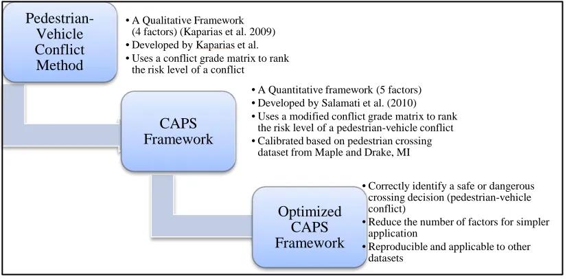
This research intends to introduce three reproducible proxy methodologies to understand the contributing factors and assess safety and accessibility of pedestrians (who are blind). These methodologies are; 1) a field observational study of pedestrian-vehicle conflicts, 2) a controlled field study of driver yielding behavior to pedestrians, and 3) a controlled laboratory study of the effect of different treatments at roundabout approaches to increase driver yielding rate. Each of three proxy methods for evaluating pedestrian accessibility offers its own advantages and shortcomings. This research demonstrates that each of the three methods can be applied to the study of pedestrian access to modern roundabouts, targeting different aspects of accessibility with an emphasis on access to pedestrians who are blind.
Time-to-collision, deceleration rate and lane condition. However the methodology requires more data collection for calibration and error reduction.
The second proxy method aims to identify the contributing factors affecting the likelihood of a driver yielding to pedestrians at two-lane roundabouts approaches. The method contributes a controlled field data collection protocol that provides event-level data on driver decisions, and is evaluated using a logistic regression approach. The logistic regression models developed from the collected data show that the likelihood of a driver yielding at the entry leg of roundabouts is higher than at the exit. Drivers tend to yield to pedestrians carrying a white cane more often than to sighted pedestrians. Drivers traveling in the far lane, relative to pedestrian location, have a lower probability of yielding to a pedestrian. As the speed increases, the probability of driver yielding decreases. At the exit leg of the roundabout, drivers turning right from the adjacent lane have a lower propensity of yielding than drivers coming from other directions. The research enables researchers to explicitly account for these factors contributing to (low) yielding at multilane roundabouts, thus target specific strategies that may improve yielding and thereby accessibility.
(PHB or RRFB) with or without crosswalk relocation, increases driver yielding rates significantly. The results of using an eye tracker on drivers to track their gaze pattern while exiting the roundabout shows that having a beacon installed with crosswalk relocation increases drivers’ attention both on the beacon and the pedestrian along the road. The study suggests the need for a more in-depth field test of crosswalk relocation at multi-lane roundabouts.
The controlled field study and controlled laboratory study are both effective in helping understand the factors that increase crossing opportunities for pedestrians and ultimately increases the accessibility of the intersection. However, the field observational study of pedestrian-vehicle interactions and the CAPS framework enables the researcher to quantify the risk level of crossing decisions made by pedestrians. The simulator study is a highly useful approach for screening potential treatment alternatives prior to filed installation of only the most promising options.
Proxy Methods for Quantifying Pedestrian Accessibility at Complex Street Crossings
by
Katayoun Salamati
A dissertation submitted to the Graduate Faculty of North Carolina State University
in partial fulfillment of the requirements for the Degree of
Doctor of Philosophy
Civil Engineering
Raleigh, North Carolina 2012
APPROVED BY:
________________________________ _____________________________ Dr. Nagui M. Rouphail, Co-Chair Dr. Bastian J. Schroeder, Co-Chair
________________________________ ______________________________
ii
D
EDICATIONThis dissertation is dedicated to my family and the educators I have had the privilege of learning from throughout my life. My entire family has supported me in all of my academic aspirations, for which I am eternally grateful.
To an amazing person and the best husband, Ramin, who provided unwavering support throughout our life together, especially during my graduate education.
To my best childhood friend and my biggest fan, grandma Maheen.
To my parents, Homa and Manouchehr, who always have unconditional love and support, provide guidance throughout my life and try to make me a better person every day.
To my brother Koroush.
iii
BIOGRAPHY
iv
ACKNOWLEDGEMENTS
I would like to express a special gratitude to Dr. Nagui Rouphail and Dr. Bastian Schroeder for their endless support throughout my graduate studies. This dissertation would not have been possible without their abundant assistant and guidance and I am deeply grateful for having the opportunity to learn from them.
Dr. Yahya Fathi and Dr. Joseph Hummer as committee members provided meaningful feedback on my research. I am appreciative for all the lessons I learned from them.
I appreciate the time and effort each of my committee members have demonstrated. I am truly grateful for my experience as a student at NC State, where I have the opportunity to work closely with some of the top transportation researchers in the United States. I am appreciative for the support I have had at the Institute of Transportation Research and Education (ITRE) from my colleagues and supervisors.
I would like to acknowledge the support of Christopher Cunningham, Janet Morgen Barlow, Dr. Richard Long, Dr. Duane Geruschat, Elizabeth Scott, Christopher Vaughan, Dr. Dave Guth and Dr. David Kaber for their assistant with data collection and feedback.
v
the staff from Ergonomics Laboratory at North Carolina State University who helped with the study.
vi
TABLE OF CONTENTS
LIST OF TABLES ... x
LIST OF FIGURES ... xii
1 INTRODUCTION AND MOTIVATION ... 1
1.1 Background ... 3
1.1.1 Pedestrian Safety Analysis of Roundabouts ... 4
1.1.2 Pedestrian Accessibility at Roundabouts ... 6
1.1.3 Current Studies in Accessibility of Roundabouts and Limitations ... 8
1.2 Research Objectives and Contribution ... 14
1.3 Limitations of the Research Approach ... 19
1.4 Dissertation Organization... 20
2 OBSERVATIONAL FIELD STUDY: CONFLICT-BASED ASSESSMENT OF PEDESTRIAN SAFETY (CAPS) FRAMEWORK ... 22
2.1 Introduction ... 22
2.2 Literature Review ... 24
2.2.1 Pedestrian Conflict Study, Safety and Accessibility... 24
2.2.2 Methodology for Vehicle-Pedestrian Conflicts ... 27
2.3 Framework Development ... 29
2.3.1 Development of an Overall Risk Score ... 37
2.3.2 Data Collection ... 39
2.3.3 Results ... 45
vii
2.5 Cluster Analysis ... 50
2.6 Implementation of Clustering to CAPS ... 53
2.6.1 Results of Clustering for CAPS ... 55
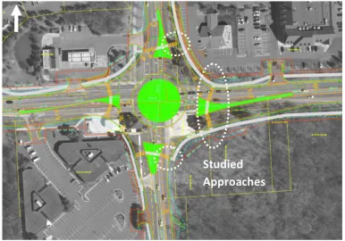
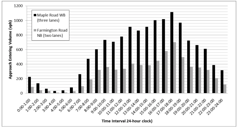
2.7 Validation of CAPS to a Dataset (Maple and Farmington) ... 58
2.7.1 CAPS Conflict Grade Matrix ... 62
2.7.2 Application of Clustering Methods to Dataset 2: Results and Discussion ... 63
2.8 Discussion and Future Work ... 64
3 CONTROLLED FIELD STUDY: DRIVER YIELDING BEHAVIOR TO PEDESTRIANS AT TWO-LANE ROUNDABOUT APPROACHES ... 67
3.1 Introduction ... 67
3.2 Background and Literature ... 68
3.3 Methodology ... 71
3.3.1 Field Data Collection and Parameters ... 74
3.3.2 Site Description ... 79
3.4 Data Analysis ... 81
3.4.1 Descriptive Statistics ... 81
3.5 Model Development ... 85
3.5.1 Modeling Approach ... 85
3.6 Results ... 88
3.7 Discussion ... 92
3.8 Conclusion and Future Work ... 98
4 CONTROLLED LABORATORY STUDY WITH DRIVING SIMULATOR... 101
4.1 Introduction ... 101
viii
4.3 Methodology ... 104
4.3.1 Driving Simulator Study ... 105
4.3.2 Experimental Design ... 107
4.3.3 Driving Simulator Measures of Effectiveness ... 111
4.3.4 Eye Tracker Measures of Effectiveness ... 111
4.4 Experiment Results ... 112
4.4.1 Yielding Rate Results ... 112
4.4.2 Participant Questionnaire Results ... 114
4.4.3 Eye Tracker Results ... 117
4.4.4 Debriefing Questionnaire on Treatment Effectiveness ... 120
4.5 Discussion and Future Work ... 122
5 CONCLUSIONS AND RECOMMENDATIONS ... 126
5.1 Research Motivation and Objectives ... 126
5.2 Summary of Findings ... 128
5.3 Contrast and comparison of the three methods ... 134
5.4 Recommendations for Application ... 138
5.5 Future Research ... 141
6 REFERENCES ... 144
APPENDIX ... 151
APPENDIX A: CONTROLLED FIELD STUDY DATA COLLECTION PROCEDURE AND PHOTOS ... 152
APPENDIX B: REGRESSION MODELS DEVELOPED FOR EACH SITE AND THE CORRELATION RABLES ... 154
ix
x
LIST OF TABLES
Table 1 Thresholds for Factor A, Time to Collision ... 32
Table 2 Thresholds for Factor B, Severity of Evasive Action ... 34
Table 3 Thresholds for Factor D, Distance to Collision ... 35
Table 4 Lane Condition Factor ... 36
Table 5 Modified Conflict Grade Matrix Based on Adding the Lane Condition Factor ... 38
Table 6 Performance measures for Clustering Methodology ... 47
Table 7 Comparison of Different CAPS Model Combinations for Two-Lane Approach, Blind Pedestrian Crossing (n=58 events) ... 48
Table 8 Comparison of Different CAPS Model Combinations for Three-Lane Approach, Blind Pedestrian Crossing (n=83 events) ... 48
Table 9 K-Mode Clustering Results for Maple and Drake Crossings ... 56
Table 10 K-Median Clustering Results for Maple and Drake Crossings ... 56
Table 11 K-Means Clustering Results for Maple and Drake Crossings ... 57
Table 12 Values of the centers of the two safe and dangerous clusters ... 58
Table 13 Original CAPS framework applied to Maple and Farmington Data Set ... 63
Table 14 Validation of selected clustering methodologies to dataset 2 ... 64
Table 15 Traffic Characteristics Collected for Yielding Study ... 76
Table 16 List of the Roundabouts Studied for Driver Yielding Behavior ... 80
Table 17 Yielding Rates and Speed Measurements for Each Site ... 82
Table 18 Descriptive Statistics for Each Site- a) Entry, b) Exit ... 84
Table 19 Results of Logistic Regression for All Sites: ... 89
Table 20 Results of Logistic Regression for All Sites: With Site Dummy Variables ... 90
Table 21 Results of Forward Selection Logistic Regression Model (Final Models) ... 91
Table 22 Latin Square Design for Randomizing the Order of Trials ... 109
xi
Table 24. Subject Attributes Effect on Drivers Yielding Behavior ... 115
Table 25. Eye Tracker Results ... 118
Table 26 Regression Models to test the Effectiveness of Each Treatment ... 118
Table 27 Yield models for entry and exit approach for Carmel Indiana ... 154
Table 28 Correlation table for yielding study variables, Indiana Entry ... 155
Table 29 Correlation table for yielding study variables, Indiana Exit ... 156
Table 30 Yield models for entry and exit approach for Nashville Tennessee ... 157
Table 31 Correlation table for yielding study variables, Nashville Tennessee Entry ... 158
Table 32 Correlation table for yielding study variables, Nashville Tennessee Exit ... 159
Table 33 Yield models for entry and exit approach for Raleigh North Carolina ... 160
Table 34 Correlation table for yielding study variables, Raleigh North Carolina Entry ... 161
Table 35 Correlation table for yielding study variables, Raleigh North Carolina Exit ... 162
Table 36 Yield models for entry and exit approach for Winston-Salem North Carolina ... 163
Table 37 Correlation table for yielding study variables, Winston-Salem North Carolina Entry ... 164
Table 38 Correlation table for yielding study variables, Winston-Salem North Carolina Exit ... 165
Table 39 Yield models for entry and exit approach for Towson Maryland... 166
Table 40 Correlation table for yielding study variables, Towson, Maryland Entry ... 167
Table 41 Correlation table for yielding study variables, Towson Maryland Exit ... 168
Table 42 Yield models for entry and exit approach for Annapolis Maryland ... 169
Table 43 Correlation table for yielding study variables, Annapolis Maryland Entry ... 170
xii
LIST OF FIGURES
Figure 1 Sources of Error in Study of Blind Pedestrian Crossings... 10
Figure 2 Application of Each Methodology to Control for Sources of Error ... 16
Figure 3 Outline of the Research ... 18
Figure 4 Aerial View of Data Collection Site: Intersection of Maple and Drake Rd. West Bloomfield MI Source: http://www.nwconnector.com ... 39
Figure 5 Hourly Distribution of Entering Volumes at Maple and Drake Roundabout ... 41
Figure 6 Screenshot of Composite Video View of Test Site ... 44
Figure 7 Advancement of CAPS Framework ... 54
Figure 8 Process of Optimizing CAPS Framework ... Error! Bookmark not defined. Figure 9 Aerial view of Second Study Location, Roundabout at Maple Rd. and Farmington Rd. MI (Source: http://www.nwconnector.com) ... 59
Figure 10 Hourly Distribution of Entering Volumes at Maple and Farmington Roundabout ... 60
Figure 11 Camera, speed measurement system and speed screen set up for studying driver yielding behavior at two-lane roundabout approaches. ... 75
Figure 12 Sample data collection Sheet for yielding study ... 78
Figure 11 Model Probability Plots for the Base Case with No Site Variable, Entry Only ... 95
Figure 12 Model Probability Plots for the Base Case with No Site Variable, Exit Only ... 95
Figure 13 Model Probability Plots for Across All Sites for, Entry ... 96
Figure 14 Model Probability Plots for Across All Sites for Exit ... 97
Figure 15 Driving Simulator Screen Shot PHB20 Scenario ... 106
Figure 16 Eye Tracker Device Source (http://www.ise.ncsu.edu/ergolab/) ... 107
Figure 17 Participants' Safety Score for each Scenario ... 121
xiii
Figure 20 Seeded pedestrian carrying a white cane standing at the crosswalk, yielding
study ... 153 Figure 22 Driving Simulator STISIM Equipment (Photo Source:
WWW.ise.ncsu.edu/ergolab) ... 173 Figure 23 View of driving simulator environment, no treatment (CTRL20) scenario ... 174 Figure 24 View of driving simulator environment, entry to the roundabout, PHB20
scenario ... 174 Figure 25 View of driving simulator environment PHB20 scenario, beacon turning
yellow while driver approaching the exit crosswalk and pedestrian ... 175 Figure 26 View of driving simulator environment PHB20 scenario, beacon turning red while driver approaching the exit crosswalk and pedestrian ... 176 Figure 27 View of driving simulator environment entry approach, RRFB20 scenario,
RRFB in dark mode ... 176 Figure 28 View of driving simulator environment, exit approach, RRFB20 scenario,
RRFB activated for pedestrian crossing ... 177 Figure 29 ASL Eye tracking System (Source: http://www.s-oliver-associates.com) ... 178 Figure 30 (Eyenal (Eye-Analysis) software interface for ASL series 5000 eye tracking
system, sample of a data set collected during the driving simulator experiment ... 178 Figure 31 Screen Shut of a Fix Plot (eye movement trajectory from the time vehicle
1
1 INTRODUCTION AND MOTIVATION
Pedestrians are vulnerable users of transportation facilities and are subjected to a higher risk than other road users (FHWA 2004). In recent years awareness about the challenges that pedestrians face using different transportation facilities has increased. Therefore, designing multipurpose facilities involves constant trade-offs between safety and efficiency for their users, especially when the user group include pedestrians. Pedestrian facilities must be accessible to all pedestrians, including those with vision or mobility impairments, as required by the American with Disabilities Act (ADA) (DOJ 1990).
Intersections are the type of transportation facility where pedestrians and vehicles directly interact, which may result in conflicts. Signals and other types of traffic control devices (such as roundabouts or stop signs) represent engineering approaches intended to balance the safety and efficiency of different types of users at intersections. These devices prioritize and enforce right-of-way rules for users by controlling the traffic movement, while assuming equal access to pedestrians with vision or mobility impairments.
2
(Schroeder et al. 2011a, Fitzpatrick et al. 2006). Modern roundabouts and channelized right turn lanes are forms of yield controlled unsignalized intersections.
Modern roundabouts represent an intersection form that has demonstrated safety benefits for motorized traffic and further offers significant operational benefits over signalized or stop control intersections in many applications (Rodegerdts et al. 2010). However, due to the mixed priority right-of-way rules at roundabouts, research has documented significant pedestrian accessibility challenges at these intersections (Schroeder et al. 2011a) for pedestrians who are blind. The Schroeder et al. (2011a) research and other prior work (Ashmead et al. 2004, Guth et al. 2005) traditionally focus on filed-based experiments at crossings with and without treatments, often involving blind study participants making supervised crossings or crossing decisions. While such approaches represent a valid and useful data collection approach, results can be subject to various sources of variability and error as described later in this section.
This research focuses on the development of propose proxy methodologies to quantify pedestrian accessibility at complex yield-controlled intersections. The methodologies are based on studies conducted at several multilane roundabouts across the United States or tested in a state-of-the-art driving simulator of multilane roundabout operations. However, all methods are applicable to other complex unsignalized intersections. The primary motivators for this research are:
3
b) Need for methodologies for evaluating different treatments at roundabouts to provide objective empirical performance data and lend decision-support when comparing treatment alternatives.
The motivation for focusing on roundabouts stems from:
a) Increasing interest in building roundabouts in the United States; b) Specific accessibility requirements by ADA for roundabouts
The following sections further explain why roundabouts are chosen as the focal point of this dissertation, offer a definition of accessibility, describe the current state of practice in studying pedestrian accessibility at complex street crossings, and discuss the shortcoming of current research approach. At the conclusion of this chapter, the objectives and limitations of this research are stated.
1.1 Background
4
The National Institutes of Health (NIH), Federal Highway Administration (FHWA), National Cooperative Highway Research Program (NCHRP), and other organizations have sponsored a series of research projects on the safety and accessibility of modern roundabouts for pedestrians, especially those who are blind (for example NIH R01 EY12894-03, TOPR #34 and NCHRP 3-78) .
Accessibility and safety of a transportation facility are not the same, but safety is one component of accessibility. The following sections distinguish safety and accessibility analysis of roundabouts for pedestrians.
1.1.1
The frequency of crashes at an intersection is related to the number of conflict points. “A conflict point is a location where the paths of two motor vehicles, or a vehicle and a bicycle or pedestrian path, diverge, merge or cross each other” (Rodegerdts 2010). Pedestrians at roundabouts face fewer conflict points compared to signalized, two-way stop-controlled and all-way stop-controlled intersections, which would arguably make them a safe intersection form. For those road users; however, the number of conflict points increase as the number of lanes increases at multilane roundabouts.
Pedestrian Safety Analysis of Roundabouts
5
signalized, they can be faced with a multiple threat situation from traffic. A multiple threat situation describes an event where a yielding vehicle in the near lane (relative to the pedestrian) may visually and auditorily mask the arrival of a vehicle in the far lane, while also obscuring the presence of the pedestrian for the driver of that vehicle (PEDSAFE 2012). Further the auditory environment is more complex than other forms of intersections and therefore challenging for blind pedestrians (Schroeder et al. 2009).
Although there have been attempts to develop crash models for roundabouts in the United States, the models are only applicable to vehicular crashes. NCHRP report 572 (Rodegerdts et al. 2007) and NCHRP report 672 (Rodegerdts et al. 2011) successfully calibrated the U.K. roundabout crash models with U.S. data, for vehicles. To date, it has not been possible to model pedestrian crashes at roundabouts in the United States since pedestrian exposures are oftentimes low, and U.S. data therefore have a very small proportion of pedestrian crashes (only 5 crashes as of 2007) (Rodegerdts et al. 2007).
6
benefits of roundabouts compared to other signalized intersections carries over from vehicles to pedestrians as reported by Rodegerts et al. (2011) in NCHRP report 762. British statistics show a 34% decrease in the number of pedestrian crashes per million trips for modern roundabouts than signals (33% and 67% respectively) (Maycock and Hall 1984, Crown 1998). A pedestrian collision study of 181 intersections converted to roundabouts in Netherlands shows a 73% reduction in pedestrian crashes and 89%in pedestrian injury crashes (Schoon and Minnen 1993). A collision study of 59 roundabouts and 124 signalized intersections in Norway shows only 3% of the crashes in roundabouts involved pedestrians versus 20% at signalized intersections (Seim 1991).
1.1.2
According to The Americans with Disabilities Act (ADA) Glossary of Terms,
Accessible “ refers to a site, facility, work environment, service, or program that is easy to approach, enter, operate, participate in, and/or use safely and with dignity by a person with a disability” (US Access Board 2011). Specifically ADA legislation requires that public transportation facilities be “accessible to and usable by” all road users, including pedestrians with vision or mobility impairments. Accessibility of a roundabout implies that all pedestrians, especially those who are disabled, are able to identify safe crossing opportunities, in terms of crossable gaps or driver yielding to pedestrians, with reasonable delays (US Access Board 2011). Therefore a low or zero pedestrian crash rate does not imply that multilane roundabouts are accessible to all pedestrians, because a highly inaccessible location may be perceived as so challenging that actual pedestrian exposure
7
is very low. Crossable gap is the time between arrivals of two consecutive vehicles at the crosswalk which is long enough so pedestrian can safely being crossing and clear the crosswalk before the next vehicle arrives. Values of crossable gap vary based on width of the crosswalk and pedestrian speed.
Several recent studies have shown that roundabouts are not easily accessible by pedestrians, especially those with vision impairments, for three primary reasons: 1) motorists fail to yield to pedestrians where the crossing is not signalized, 2) noise from circulating traffic can make auditory detection of gaps difficult (especially at the exit), and 3) gaps large enough to be aurally detected may be infrequent (Schroeder et al. 2006, Schroeder et al. 2009). As a result, the United States Access Board has drafted guidelines that call for the provision of accessible pedestrian-actuated signals at multi-lane roundabouts to make them accessible (US Access Board 2011). There is concern in the engineering community that such general requirements will unnecessarily increase the cost of this very safe intersection form. Further, research has already identified non-signal treatments that may be adequate in some cases including a raised pedestrian crossing (Schroeder et al. 2011a). The roundabout and accessibility community is in need of more research to evaluate and compare different crossing geometries, as well as the effectiveness of pedestrian crossing treatments.
8
methodologies for quantifying accessibility for pedestrians at complex intersections, discuss the shortcomings and sources of error in the status quo approaches and explain how and where the methods in this document are applicable to fill some of the gaps in research.
1.1.3
The Americans with Disabilities Act (ADA) requires that new and altered facilities be designed and constructed to meet an equivalent ('accessible') standard. The draft Public Rights-of-Way Accessibility Guidelines (PROWAG) set minimum criteria for meeting this legal requirement, thus serving as a safe place for designers (who may pursue other methods that can be shown to provide equivalent facilitative) (US Access Board 2011). The draft PROWAG presently stress the use of accessible pedestrian-actuated signals for multi-lane crossings at roundabouts and channelized turn lanes. There is a need to develop a method or methods that can be used to efficiently and safely evaluate the accessibility of an intersection to various groups of pedestrians, including those with vision impairments. At the same time, the methods should provide detailed data on the interaction of pedestrians and vehicles that are sensitive to variations in pedestrian behavior, traffic operational parameters, and roadway design changes from one intersection to another, including the use of infrastructure-based crossing treatments.
Current Studies in Accessibility of Roundabouts and Limitations
9
maintaining alignment during crossing (Schroeder et al. 2011a). Identifying a crossing opportunity is the matter that is addressed in this dissertation.
NCHRP Report 674, Crossing Solutions at Roundabouts and Channelized Turn Lanes for Pedestrians with Vision Disabilities (Schroeder et al. 2011a) and NIH/NEI Bioengineering Research Grant R01 EY12894-03 (NIH 2010) are national research efforts intended to study and improve accessibility for visually impaired pedestrians at various facilities, and under consideration of different types of infrastructure-based crossing treatments. These research studies created and applied an analysis framework to “quantitatively describe the crossing performance of individual pedestrians as well as to quantify the accessibility impacts of the tested crossing treatments” (Schroeder et al. 2011a). The “Accessibility Framework” consists of four components:
1- Availability of sufficient crossing opportunity in forms of vehicle yields and crossable gaps;
2- Detection and utilization of crossing opportunity by (blind) pedestrians; 3- Reasonable delay time associated with utilizing a crossing opportunity; and 4- Degree of risk (safety) associated with each crossing opportunity.
10
under varying treatment conditions, and documenting risky crossing decisions (Schroder et al. 2011a, Ashmead et al. 2005).
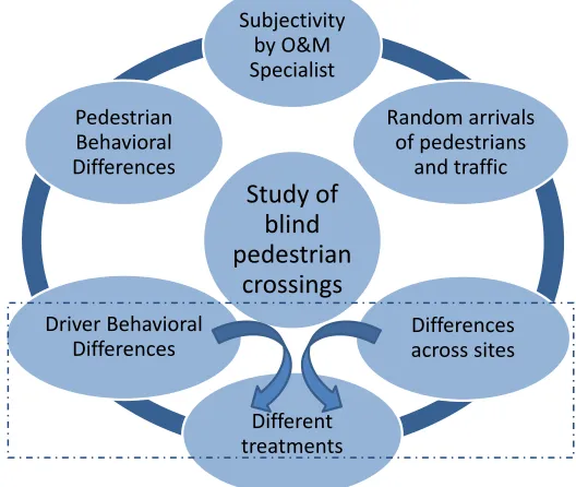
Besides being time-consuming and expensive, there are six different sources of noise or error in such studies of blind pedestrian crossings. The sources of error and/or variability are subjectivity by the O&M specialist, pedestrian behavioral differences, driver behavioral differences, random arrival of pedestrians and traffic, differences across sites and different types of treatments. Figure 1 shows the six sources of error and/or variability in study of blind pedestrian crossings. Each of these errors is explained below.
Figure 1 Sources of Error in Study of Blind Pedestrian Crossings
Subjectivity by the O&M Specialist: The current studies of pedestrian crossings available in literature put participants in potentially risky and unsafe situations, and participants must at all times be accompanied by an Orientation and Mobility (O&M)
Study of blind pedestrian
crossings
Subjectivity by O&M Specialist
Random arrivals of pedestrians
and traffic
Differences across sites
Different treatments Driver Behavioral
11
specialist to assure participant safety. A primary safety measure in these studies is the
O&M Intervention, which is defined as the O&M specialist physically stopping the participant if he or she decided to step into the roadway to begin crossing at a potentially dangerous time.
Although interventions are a valid measure and have significantly helped bring this area of research forward, they have some drawbacks. Crossing experiments are costly and require more time and professional human resources (O&M specialist), therefore it is difficult to maintain consistency in running the experiment and replicate the results. Clearly, these intervention events or pullbacks are important indicators of risk, but are limited for several reasons. Interventions are:
- Subjective
-
, in that they are critically linked to one individual’s perception of risk (the O&M specialist);
Binary
-
, in that they can only distinguish between ‘safe’ and ‘risky’ without distinguishing between different levels of risk;
Dangerous,
With (blind) pedestrian safety being the primary measure to evaluate accessibility, a study approach and evaluation framework is needed that can quantify pedestrian risk in a safe, objective, and consistent manner.
since they are the direct result of a potentially dangerous crossing decision.
12
the form of crossable gaps and driver yields, and the safe judgment of pedestrians of these crossing opportunities. Studies of blind pedestrian crossings occur during different traffic patterns, time of day, peak or off peak conditions. Not availability of crossable gaps is affected by traffic volume but driver behavior may also be influenced by time of day (e.g. peak or off peak time periods). In addition to that, a driver that approaches one pedestrian standing at the crosswalk might have a different reaction than approaching a group of pedestrians waiting for crossing opportunity. The hypothesis that random arrivals of pedestrians and traffic affects the study of blind pedestrian crossing and to the size of the effect need to be tested by controlling for these variables. Current field studies may test some participants at low traffic conditions and others during much busier traffic periods. The performance of each participant is thus always tied to operating conditions, making general conclusions about accessibility challenging.
13
14
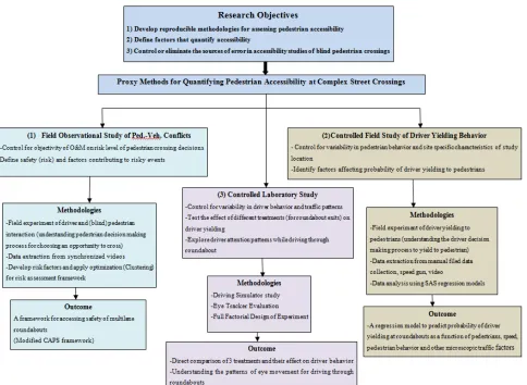
1.2 Research Objectives and Contribution
This research aims to develop objective and reproducible proxy methodologies to quantify pedestrian accessibility at complex unsignalized intersections such as multilane roundabout, while controlling for pedestrian behavior, driver behavior, traffic patterns, site geometric attributes, and presence of crossing treatments. The previous section discussed the sources of error in current methodologies for blind pedestrian crossings which is to describe the crossing performance of blind pedestrians and an attempt to quantify pedestrian accessibility. The objective of this dissertation is to addresses these sources of variability by introducing three proxy methodologies. Each of the tested methods controls for one or more common sources of error reducing the amount of observed variability and noise in collected data.
Each of the methodologies presented here attempt to address one of the components of the “Accessibility Framework” as well as controlling for sources of error. However, these methods have their own limitations which are addressed in the next section.
The research offers three principal contributions in the form of different methodological approaches for studying pedestrian accessibility and for overcoming one of more of these sources of variability:
1. Field observational studies of vehicle-pedestrian interaction for pedestrian crossings at multilane roundabouts and development of a conflict-based
15
accessibility framework which is “degree of risk associated with each crossing decision” and attempts to control for the error originated from “subjectivity by O&M specialist”. The goal of CAPS is to present a consistent framework that quantifies the level of risk for each pedestrian crossing decision based on the characteristics of pedestrian-vehicle interaction and aims to control for subjectivity of O&M decision by introducing a formulized and objective risk assessment metric.
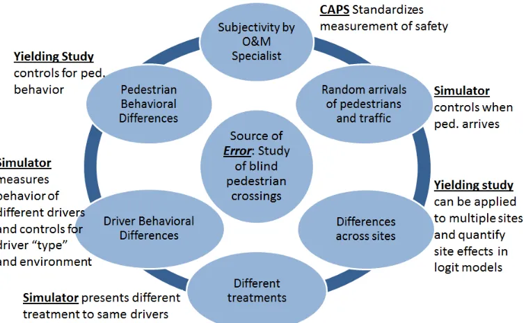
2. Controlled field experiment for evaluating driver yielding behavior to pedestrians at multilane roundabouts. This study explores the dynamics of the driver decision making process to yield to pedestrians at multilane roundabouts. The approach attempts to address the first component of the accessibility framework which is the availability of crossing opportunities. However this study only focuses on driver yielding as a form of crossing opportunity. Availability of crossable gaps is not discussed in this document but is well covered in the traffic literature. The methodology attempts to control for pedestrian behavioral differences and differences across sites.
3. Laboratory based study that explores different pedestrian treatments at the exit leg of roundabouts to increase driver yielding rate, in a driving simulator
16
random arrival of pedestrians and traffic. It also controls for driver behavioral differences by enabling the researchers to test the study on a particular cohort of drivers as needed.
Figure 2 Application of Each Methodology to Control for Sources of Error and Varibility
17
18
19
1.3 Limitations of the Research Approach
The research presented does not address all components of the accessibility framework. Regarding the crossing opportunity component, the studies do not focus on availability of crossable gaps as a form of crossing opportunity. They also do not address what factors might affect the availability of crossable gas. The studies also do not provide methods to quantify crossing opportunity utilization by pedestrians, which is the second component of accessibility framework. In other words they don’t explain why or when blind pedestrians do not detect or utilize a crossing opportunity, or why they made a crossing decision when it wasn’t crossable.
The proxy methodologies described in this research do not deal with pedestrian delay while making a crossing decision at complex street crossings. Schroeder et al. (2011 a) attempted to formulated pedestrian delay based on data collected from previous blind pedestrian crossings. However, this research focuses on risk assessment rather than delay.
Although the proxy methodologies in this document attempt to control for various sources of error in data collection and study of blind pedestrian crossings, each proxy method has its own limitations. This research consists of observational and controlled field data collection studies, and a controlled laboratory experiment using a driving simulator. The limitations of the research are therefore also associated with the limitations of the data collection methods themselves.
20
-The sample size of blind and sighted participants (as pedestrians) in the observational study is limited to two datasets. The datasets are collected from two-lane and three-lane approaches of two multilane roundabouts in Michigan. The first data set include 141 pedestrian crossings and the second dataset includes 114 indications of when the pedestrians would cross.
-The calibration of the CAPS framework is based on human judgment of O&M specialists on safe and risky events, therefore is somewhat subjective.
-Data collected for the observational study is limited to two roundabouts in Michigan.
For the controlled field study:
-Data collection is limited to six two-lane roundabouts in North Carolina, Tennessee, Maryland and Indiana.
- No treatments (other than roundabout geometric differences) were considered For controlled laboratory study with driving simulator:
-The pedestrian treatments are only studied for the exit leg of the roundabouts. - The subjects do not represent all the driver population, but reflects a sample of 45 study participants
- Simulator driving is not necessarily synonymous with real-world performance
1.4 Dissertation Organization
21
safety and accessibility issues at multi-lane roundabouts as one type of unsignalized complex intersection.
The document then develops a pedestrian-vehicle framework to evaluate the risk level of an interaction between a pedestrian and a vehicle at the crosswalk in Chapter 2. Chapter 3 aims to understand the contributing variables to increasing the driver yielding rate. Chapter 4 presents a controlled driver simulator study to evaluate various treatments for increasing driver yielding rates.
22
2 OBSERVATIONAL FIELD STUDY: CONFLICT-BASED ASSESSMENT OF
PEDESTRIAN SAFETY (CAPS) FRAMEWORK
2.1 Introduction
One of the components of Accessibility framework is whether pedestrians make safe crossing decisions or not and to quantify the level of risk associated with each crossing decision. Unsafe crossing decisions will result in a conflict between pedestrian and vehicle and might also lead to a collision. Collision data is currently the primary source of assessing safety of a transportation facility. However, it is in the best interest to avoid collision and focus on other substitute measures to assess safety of a pedestrian crossing.
In absence of collision data, traffic conflict techniques are being used. For the study of blind pedestrian crossings the judgment of O&M specialist for a pedestrian-vehicle interaction is used to classify the event as safe or potential collision. The goal of this chapter is to introduce a proxy method, in form of a pedestrian-vehicle conflict framework that substitutes the judgment of O&M specialist about the risk level of each pedestrian crossing decision. Another goal is to quantify the level of risk for each pedestrian crossing decision and describe the pedestrian-vehicle interaction based on the dynamics of the factors involved in the interaction.
23
pedestrian safety (CAPS) framework is introduced in this chapter which is built on a pedestrian-vehicle conflict framework. The framework consists of five microscopic traffic attributes that describe the interaction between a pedestrian and a vehicle while the pedestrian is utilizing a crossing opportunity at a crosswalk. The overall structure of CAPS framework is developed and calibrated using the data from 141 crossing events of blind and sighted pedestrians at two-lane and three-lane approaches of a multilane roundabout. For all of these crossing events the risk level of crossing decision (safe or dangerous) is identified by an Orientation and Mobility (O&M) specialist. The performance of the framework is evaluated by correctly identifying the safe and dangerous events against the O&M ranking of each crossing events.
24
2.2 Literature Review
2.2.1
According to the National Highway Traffic Safety Administration (NHTSA), 12% of the fatal crashes that took place across United States were pedestrian fatalities in 2009 (NHTSA 2010). Crash analysis is one of the ways to evaluate the safety of a transportation facility, identify the hazardous locations and factors causing collisions, and suggest countermeasures to improve safety of transportation facilities by means of reducing collisions. In order to do so, however, collisions must have happened, reported and documented properly. Studies show there is a lack of sufficient pedestrian-vehicle collision data at multilane roundabouts in United States (Schroeder et al. 2011a, Rodegerdts et al. 2010).
Pedestrian Conflict Study, Safety and Accessibility
Other approaches for quantifying the safety of a transportation facility have been developed, including Traffic Conflict Techniques. The use of such one alternative, Traffic Conflict Techniques (TCT), is justified by the following key characteristics (Muhlrad 1993)
a. Unreliability and lack of quality of collision statistics in many countries. b. Unavailability of detailed collision data either because it does not exist or
it is not stored and classified properly.
c. Even with existence of collision data, usually additional information is needed to test any safety hypothesis.
25
a) “To get some control on the development of transportation and traffic systems in order to avoid creating malfunctions that could later produce collisions.
b) To prepare corrective action in connection with actual collision problems identified through objective studies.
c) To select or design safety measures which only influence some of those particular elements of the transportation system that have been found to contribute to the main collision problems.
d) To coordinate planning and implementation of comprehensive safety measures with a view to increasing their joint effects.
e) When possible, to coordinate design and implementation of safety measures and other measures that may include or support them.
f) To avoid redundancies and/or contradictions in road safety programs or between safety and other programs related to transport and development. g) To make the best use of past experience in other cities, countries or
regions of the world, after checking its relevance and possible adaptation to the conditions in the country (or the city).
h) To contribute to produce relevant knowledge by following up the effects of the measures and policies implemented in the country (or the city).”
26
conflict is characterized by the fact that no one voluntarily gets involved in such a situation.” (Hayden 1987).
Traffic conflict analysis has been viewed as an effective way of preventing collisions from happening since its origin in the late 1960’s (Hamilton-Baillie, 2004) as it can provide valuable information on potentially dangerous road sites before collisions actually happen on them. A substantial amount of research has been conducted on the topic, resulting in development of many traffic conflicts techniques (Huhlrad 1993, Hyden 1987, Allen 1978). While initial analysis methods were more qualitative and applied subjective measures to identify and characterize evasive actions of road users in response to conflicts, newer methods have become more quantitative and have provided more precise definitions for measures of the severity of conflicts (Muhlrad 1993).
27
More specifically, the STCT focuses upon evaluating the time to collision and vehicle speed at the beginning of an evasive action to categorize the different conflicts according to severity. The USDTCT and the IHTCT, on the other hand, are based on categorizing the various elements of the conflict and creating levels of severity for each element, such that by summing up the given element levels an overall grading of the severity of the conflict can be obtained.
Although the concepts underlying these methods are applicable to various modes of transportation, conflict analyses are most often applied to vehicle-to-vehicle conflicts. However, some examples of work on conflicts between vehicles and other road users can be found in the literature, mostly for the purpose of assessing the safety of pedestrian crossings and the interactions within traffic flows. Some researchers have implemented existing traffic conflicts methods for modeling vehicle-pedestrian interactions. Both the STCT and the USDTCT have been used to analyze conflicts with pedestrians; in other studies. USCTCT method by Parker et al. (1989) is used by Lord (1996) to model the interaction between left-turning vehicles and pedestrians at signalized intersections and the STCT is used by Chen et al. (2009) to assess the efficiency of the safety regulations for vulnerable road users at intersections in Beijing.
2.2.2
Although a number of conflicts analysis methods have been used to model vehicle-pedestrian interactions, none of them has been developed for unsignalized complex intersections with mixed priority rules (for example, yield-controlled intersections like roundabouts). Since in such transportation facilities there is ambiguity when and where
28
pedestrians have priority over vehicles or vice-versa. This has an effect on behavior of pedestrians and vehicles and therefore traffic conflicts.
Kaparias et al. (2010) developed a vehicle-pedestrian conflict analysis method based on the IHTCT framework. The authors' vehicle-pedestrian conflict analysis method was developed to evaluate shared vehicle and pedestrian spaces in the UK. The method uses four factors to describe different aspects of a conflict, with each factor further having different classes of severity. Based on the class of severity of each factor, a composite safety rating is obtained to classify the overall pedestrian-vehicle interaction event. The four factors in the Kaparias et al. (2010) framework are as follows.
• Factor A, ‘time to collision’, (TTC) is the time between an approach point and the potential collision between a pedestrian and a vehicle. TTC is illustrated in three classes of long, moderate, and short, with short being the most severe of the three classes.
• Factor B, ‘Severity of evasive action’ (SEA) is related to the value of deceleration rate. For pedestrians, this corresponds to different qualities of
reaction to change course from walking to running or emergency action. Factor B has four classes of severity: light, medium, heavy, and emergency.
29
• Factor D, ‘distance to collision’ (DTC) is the distance of the following vehicle from the point of conflict when an evasive action has taken place. Factor D has three classes: far, medium, and short.
In the Kaparias et al. (2010) framework, all four measures are obtained from video observations of pedestrian crossings in shared-space environments. All four factors are qualitative. For example, time-to-collision is classified into three broad categories by an expert observer, rather than relying on actual measurements of vehicle dynamics (vehicle speed and position relative to the crossing point). This research adopts the framework developed by Kaparias et al. (2010) and customizes it to make it appropriate for quantifying the study in order to access the safety of pedestrian crossings at multilane roundabouts.
2.3 Framework Development
30
crossings of sighted and blind pedestrians at multilane roundabouts. It can therefore be used to quantify crossing risk at a site for all categories of pedestrians.
The objective of this section is to describe a framework that can be used to efficiently and safely evaluate the accessibility of an intersection to various groups of pedestrians, including those with vision impairments. The Conflict-based Assessment of Pedestrian Safety (CAPS) method is compatible with indicator-based studies, in which visually impaired participants stand at the crosswalk and indicate when they would cross by raising their hand as oppose to physically stepping into the road (Guth et al., 2005). At the same time, the method should provide detailed data on the interaction of pedestrians and vehicles that are sensitive to variations in pedestrian behavior, traffic operational parameters, and roadway design changes from one intersection to another, including the use of infrastructure-based crossing treatments. These objectives are motivated by findings and recommendations for future research of two multi-year research projects on the accessibility of complex intersections to pedestrians with vision impairments (Schroeder et al. 2011a, NIH 2010).
31
The CAPS risk factors are based on measures of vehicle dynamics, which are estimated at the instance the pedestrian steps into the roadway (crossing study); or alternatively, at the time when the pedestrian indicates that he or she would cross (indicator study). In this research, the framework was calibrated from actual crossings (with some interventions), but for future applications, all factors are compatible with indicator studies. A total of five factors are used to define various aspects of the pedestrian-vehicle interaction. They are combined to develop the composite safety score of the crossing decision. The five factors are defined as follows:
• Factor A, “Time to Collision”. Defined as the expected arrival time of the vehicle at the crosswalk given its instantaneous speed and relative position to the crosswalk. Time to collision (TTC) is calculated separately for each approach lane considering when the pedestrian would arrive in that lane based on his or her walking speed. TCC for each lane is calculated based on the formula in Equation 1:
Equation 1
𝑇𝑇𝐶 (𝑖) =𝑑𝑉 −𝑐𝑤 (𝐿𝑊)∗𝑉(𝑖 −1)
𝑝
where,
TTC (i) (sec.): TTC for lane i, where i has levels 1, 2, and 3 for a three-lane and levels 1 and 2 for a two-lane crossing. Lane 1 is defined as the lane closest lane to the pedestrian or indicates intent to cross
dcw (ft.): The distance from the vehicle to the crosswalk at the time
32
LW (ft.): Lane width of each vehicular travel lane.
V (ft/sec): Vehicle speed measured at the time the pedestrian starts crossing or indicates intent to cross
Vp: (ft/sec): Pedestrian walking speed
According to this definition, TTC can take on a negative value. A negative TTC implies that the vehicle would have passed the collision point by the time the pedestrian reached the lane it is traveling in. In the CAPS framework, Factor A is divided into three classes with thresholds given in Table 1. Class 1 is a long (and safe) TTC which describes as either the vehicle passed the course of the crosswalk before pedestrian arrives at the conflict point (-2 seconds) or is far enough ( 8 seconds) that it will not cause any threat for the pedestrian. Class 2 or moderate TTC is chosen between 5 to 8 seconds. Class 3 or short TTC is identified as the most risky and with high likelihood of a conflict between pedestrian and vehicle. The thresholds for factor A were defined by observing hours of video data for pedestrian street crossings and measuring the TTC for each crossing. Each of the thresholds for TTC levels of severity were chosen conservatively.
33
34
Table 2 Thresholds for Factor B, Severity of Evasive Action Factor B Deceleration Rate
(ft./sec2)
Deceleration Rate (m/sec2) Light [Class 1] DECEL < 6.56 DECEL < 2.00 Medium [Class 2] 6.56 <DECEL< 11.31 2.00 <DECEL< 3.45 Heavy [Class 3] 11.31 <DECEL< 16.40 3.45 <DECEL< 5.00 Emergency [Class 4] DECEL > 16.40 DECEL > 5.00
• Factor C “Complexity of Evasive Action”. This factor describes qualitatively any evasive action by pedestrian or driver that would signify a potentially risky interaction. This factor is estimated by observing the pedestrian behavior while crossing the street (for example if they are running or swirling around a vehicle to avoid conflict) or by estimating the speed of the vehicle and observing driver behavior (for example changing lane or not paying attention to the pedestrian).The factor is largely consistent with factor C that Kaparias et al.(2010) and is estimated by watching video recordings of the pedestrian crossing study. The factor has two levels, simple and complex, where the latter is any event associated with a vehicle swerving into adjacent lanes or a pedestrian jumping out of the way of an approaching vehicle.
35
be 10 ft. ( 3 meters). Therefore, with pedestrian speed of 3.5 ft/sec. ( as defined in HCM 2010) the pedestrian needs approximately 3 seconds to finish crossing one lane. Most roundabouts have entry speed limit of 25 mph (11 m/sec.) and vehicles are decelerating while approaching the crosswalk. However it is assumed that an average speed for vehicle approaching the roundabout is considered to be 30 mph ( 44 ft/sec. and 13.4 m/sec.). Therefore the vehicle should be approximately 130 ft. (40 m) away to allow pedestrian enough time to clear the crosswalk, hence the 130 ft. thresholds for class1. Thresholds for class2 and class 3 are also defined based on same calculations and assumptions.
Table 3 Thresholds for Factor D, Distance to Collision Factor D Distance to Collision
(ft.)
Distance to Collision (m)
Far [Class1] DTC>130 DTC>40
Medium [Class2] 50<DTC<130 15<DTC<40
Short [Class3] DTC<50 DTC<15
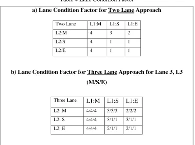
• Factor E "Lane Condition Factor". This last safety measure was added in order to describe the relative state of each conflicting lane. At a multi-lane crossing, the multiple threat crash type is common, Factor E in the CAPS framework is assigned four classes based on the state of the vehicle in each lane at the time when the pedestrian initiates crossing. The vehicle state in each lane is defined as empty (E) ,
36
situation of each lane and it is presented in Table 4. The matrices in Table 4 are the results of several discussions to define what condition should be considered safe or risky. In general where there is a moving vehicle in near lane with respect to pedestrian, the condition is risky (lane condition factor of 4). In case of a stopped vehicle in near lane, the multiple threat condition may happen which is also risky (lane condition factor of 3 or 4).
Table 4 Lane Condition Factor
a) Lane Condition Factor for Two Lane Approach
b) Lane Condition Factor for Three Lane Approach for Lane 3, L3 (M/S/E)
L1 refers to the near lane, L2 to the middle lane and L3 to the far lane with respect to
pedestrian starting position. Vehicle states are defined as M: Moving, S: Stopped/Yielding
and E: Empty. Lane condition factor is defined on the scale from 1 to 4, with 1 being safest
and 4 being the most risky situation.
Two Lane L1:M L1:S L1:E
L2:M 4 3 2
L2:S 4 1 1
L2:E 4 1 1
Three Lane L1:M L1:S L1:E L2: M 4/4/4 3/3/3 2/2/2
L2: S 4/4/4 3/1/1 3/1/1
37 2.3.1
Each of the five factors mentioned above has two to four levels, providing a rank of the severity of the factor for each of the crossing events. To assess the overall risk score of a pedestrian crossing event, the five factors must be aggregated into a single numerical risk estimate. A conflict grade matrix to estimate this overall risk score was developed by Kaparias et. al. (2010), which shows different combinations of factors and assigns a conflict grade to each combination. By taking into account the new factor E, the conflict grade matrix is revised and presented in
Development of an Overall Risk Score
38
Table 5 Modified Conflict Grade Matrix Based on Adding the Lane Condition Factor
Factor Grade 1 conflict
A 1 1 1 1 1 1 1 1 2 2 2 2 2 2 3 3
B 1 1 1 2 2 2 1 1 1 1 1 2 2 1 2 2
C 1 1 3 1 3 1 1 3 1 3 1 1 3 1 1 3
D 1 1 1 1 1 1 2 2 1 1 2 1 1 1 1 1
E 1 2 1 1 1 2 1 1 1 1 1 1 1 2 1 1
Factor Grade 2 conflict
A 1 1 1 1 1 1 2 2 2 2 2 2 3 3 3 3 3 3 3 3 1
B 1 1 2 2 3 3 1 1 2 2 3 3 1 1 1 3 1 2 3 1 1
C 1 3 1 3 1 3 1 3 1 3 1 3 1 3 1 3 3 1 1 1 3
D 3 3 2 2 1 1 3 2 2 2 1 1 2 2 3 1 3 2 1 1 1
E 1 1 1 1 1 1 1 1 1 1 2 2 2 2 2 2 2 2 2 3 2
Factor Grade 3 conflict
A 1 1 1 1 2 2 2 2 2 2 2 3 3 3 3 3 3 3 3 3 3
B 2 2 3 3 1 2 2 3 3 3 3 2 2 2 3 3 4 4 4 4 1
C 1 3 1 3 3 1 3 1 3 1 3 3 1 3 1 3 1 3 1 3 1
D 3 3 2 2 3 3 3 2 2 3 3 2 3 3 2 2 1 1 2 2 1
E 3 3 3 3 2 3 2 3 3 4 4 3 4 4 4 4 4 4 4 4 4
Factor Grade 4 conflict
A 2 2 3 3 3 3
B 4 4 3 3 4 4
C 1 3 1 3 1 3
D 3 3 3 3 3 3
E 4 4 4 4 4 4
39
various attempts to develop other simplified methods for determining the overall safety score of a crossing attempt by simple summation of the individual factors or weight the summation equation in favor of one or more factors. But they did not result in notable improvements in model fit.
Later in this chapter other methodologies such as optimization methods (three clustering algorithms) are used to substitute the conflict grade matrix in Table 5.
2.3.2
The case study below explains implementation of CAPS to data collected Data Collection
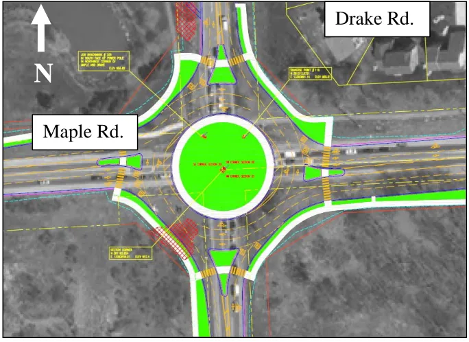
Figure 4 shows the aerial view of the data collection site.
Figure 4 Aerial View of Data Collection Site: Intersection of Maple and Drake Rd. West Bloomfield MI Source:
Maple Rd.
Drake Rd.
40
The CAPS method was implemented and calibrated from a dataset of actual pedestrian crossings collected at a multilane roundabout at the intersection of Maple Rd. and Drake Road in West Bloomfield Township in Michigan. This roundabout has two-lane approaches going north-south and three-two-lane approaches going east-west. With the distinction of the entry and exit portions of the crossing, a total of four conditions can be compared: two-lane entry, two-lane exit, three-lane entry, and three-lane exit.
41
Figure 5 Hourly Distribution of Volumes at Maple and Drake Roundabout
Fourteen blind and six sighted individuals participated in this study. After consent was obtained from each participant, they were oriented to the roundabout by the O&M specialist. Orientation included exploring a tactile map of the intersection and walking around the roundabout in a counterclockwise direction, beginning at the northwest corner. The O&M specialist described features, guided participants across the crosswalks, monitored their independent crossings, and provided instruction on the study procedures (e.g., starting point for trials, verbal instructions, safety concerns). Participants were encouraged to ask questions about the layout of the intersection and crosswalks, the traffic movement, the pedestrian facilities available, and any other features of interest. They also asked questions about the study procedures.
42
round trip crossings therefore yielded 32 crossings per participant Practice crossings prior to beginning trials helped to familiarize the participants with the study protocol, but these were not included in the analysis.
Participants were told to begin crossing whenever they believed it was appropriate to do so, using the cues that were available to them (visual cues for sighted participants, the sounds of traffic for blind participants, and additional visual and/or auditory information cues. They were not requested or required to have any verbal interaction with the spotter prior to initiating the crossing. The starting location (e.g. entry or exit leg at a roundabout) was systematically varied to control for order effects. Trials were blocked, or grouped, by crosswalk to save time and to avoid confusing the participants. For example, all crossings across Drake Road were completed consecutively, and then the team moved to Maple Road and completed all crossings there.
43
whenever you are ready”, they should identify a safe time to begin crossing, and then begin to cross the street without verbal interaction with the O&M specialist. The O&M specialist stopped each participant on the opposite side of the street (or on the splitter island) at the end of each crossing. The O&M specialist then guided the participant along the sidewalk and away from the crosswalk approximately 50 feet (if on the curb), turned around, and then approached the crosswalk to start the next trial. On the splitter island proper, the O&M specialist guided the individual forward to the crossing point on the opposite side of the splitter island. Participants were allowed to take a break as needed, and refreshments were provided. After all crossings were completed, each participant completed a short debriefing questionnaire
In total, 224 crossings for blind participants and 96 crossings for sighted participants occurred on each approach. The actual number of crossings for some participants is less than 32 due to inclement weather conditions or other factors.
44
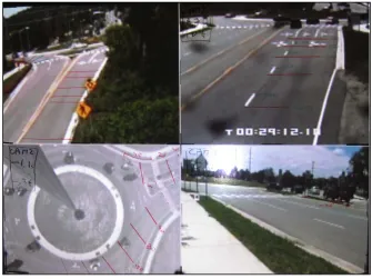
microphone used by the O&M specialist. All four camera views were synchronized in the office and recorded onto one common DVD with a split-screen view of all four video angles. These video discs were used to estimate vehicle-related measures such as distance to collision, speed, time to collision and required deceleration rate. Vehicle data were estimated for each vehicle that was in the approach of the crosswalk when a pedestrian crossing decision was made. Figure 6 shows a screen shot of the composite video angle used for data collection in the office. A detailed video time-stamp and known distances obtained from field measurements were superimposed on the video during playback to estimate vehicle speed and position data.
45
The dataset used to calibrate the CAPS framework was extracted from approximately 168 hours of video observations.
2.3.3
This section presents the results of implementing different combination of factors in the CAPS framework to the dataset. The objectives of this effort for the Maple Rd. and Drake Rd. dataset were to; a) demonstrate the feasibility of the CAPS approach, and b) calibrate the optimal combination of factors in the framework. At the two-lane approach, 28% (58/209) of the crossings by blind participants took place when there was a moving car in either of the two lanes. For the three lane approach, 37% (83/222) of the crossings took place when there was a moving car in one of the three lanes. For the six sighted participants at the two-lane approach, 14% (14/96) of the crossings occurred when there was a moving vehicle in either of the lanes. For the three-lane approach, only, 10% (10/96) of the crossings took place when there was a moving vehicle in any of the three lanes. The rest of the crossings occurred when all lanes were either empty or had stopped vehicles. The threshold for considering an approach lane as “empty” was defined at a distance of 300 ft. (100 m) from the crosswalk which corresponds to a time of approximately 10 seconds at a speed of 20 mph (30 ft./sec, 10 m/sec). In the CAPS framework, crossings that occur at times when all lanes are empty (or when all lanes have yielded) are defined to be safe. For consistency the crossing of sighted pedestrians are separate from blind pedestrians. The crossings by sighted pedestrians were all identified as safe decisions by O&M specialists. They were also identified as conflict grade of 1
46
(safe) by CAPS framework. The relative risk of the remaining 141 events was evaluated using the five CAPS factors. The calibration goal of the CAPS framework is to correctly predict the O&M intervention events with grades 3 and 4.
2.3.3.1
In order to evaluate the performance of the CAPS framework and any clustering optimization methodology, two performance measures are defined to measure the error of framework in correctly indentifying safe and dangerous (intervention) events. It is important to note that the O&M ratings of safe and intervention are considered “ground truth” and outcomes of the CAPS framework (and the three optimization algorithms used later in this chapter) are compared with the O&M ratings.
Definition of Performance Measures (Difference)
The definitions regarding the performance measures are:
True state of each event: safe or dangerous (as identified by O&M intervention)
Declared state of each event: safe or dangerous ( as estimated by the CAPS framework) Therefore we have;
TS: Number of “true safe” data points;
TD: Number of “true dangerous” data points;
DS: Number of “declared safe” data points by framework or clustering algorithm;
DD: Number of “declared dangerous” data points by framework or optimization clustering algorithm.
47
Table 6 Performance measures for Clustering Methodology State of the data point True Safe True Dangerous
Declared Safe Correct Safe=(DS given TS)/TS False Negative=(DS given TD)/ TD
Declared Dangerous False Positive=
(DD given TS)/ TS
Correct Dangerous=
(DD given TD) /DS
It is very important to reduce the value of false negatives to zero. Although the optimum combination is the one with the smallest false positive and false negative values, false positive values greater than zero only shows that the model may overestimate dangerous events. False negatives, on the other hand, mean that the framework missed a potentially dangerous crossing event. A (systematic) false positive error is acceptable, since in the interpretation this simply makes the framework somewhat more conservative than the O&M intervention measures.
48
Table 7 Comparison of Different CAPS Model Combinations for Two-Lane Approach, Blind Pedestrian Crossing (n=58 events)
Model False Positive % False Negative %
Number of Missed
Interventions (out of 12)
ABCD 1.8% 8.6% 5
ABCDE 4.3% 0% 0
AE 13.4% 8.6% 5
BE 12.9% 8.6% 5
ABE 13.4% 8.6% 5
ADE 13.9% 8.6% 5
BDE 19.1% 8.6% 5
ABDE 50.0% 0.0% 0
Table 8 Comparison of Different CAPS Model Combinations for Three-Lane Approach, Blind Pedestrian Crossing (n=83 events)
Model False Positive % False Negative%
Number of Missed
Interventions (out of 23)
ABCD 6.7% 5.6% 5
ABCDE 9.0% 0.0% 0
AE 14.6% 10.1% 9
BE 19.1% 6.7% 6
ABE 49.4% 2.2% 2
ADE 50.6% 3.4% 3
BDE 19.1% 5.6% 5
ABDE 22.5% 1.1% 1
49
factor “C”. The tables thus could assist future researchers to focus on those combinations that show promise in capturing the actual crossing conflict severity.
2.4 Optimization of CAPS
50
crossings at multilane roundabouts and assess their accessibility, without imposing any serious risks on human subjects, and being compatible with the indicator studies.
The next step is to use optimization. Optimization will be used for three purposes: a) Assign a risk score to each crossing event which is compatible with O&M’s evaluation of safe and risky events;
b) Reduce the number of factors if possible; and c) Reduce the grades of conflict (risk scores).
Three clustering algorithms, K-mode, K-median and K-means are used. The methodologies are briefly described in the following sections along with their application for optimizing the CAPS framework.
2.5 Cluster Analysis
Cluster analysis groups data objects based only on information found in the data that describes the objects and their relationships. The goal is that objects within a group be similar (or related) to one another and different from (or unrelated to) the objects in other groups. The greater the similarity (or homogeneity) within a group, and the greater the differences between groups, the better or more distinct are the clustering (Everitt et al. 2001).