IMLBTR Based Localization of Wireless
Sensor Network in the Wild
Irin Kurian1, S.Kavitha2
P.G Scholar, Department of ECE, Hindusthan Institute of Technology, Coimbatore, Tamil Nadu, India 1 Assistant Professor, Department of ECE, Hindusthan Institute of Technology, Coimbatore, Tamil Nadu, India2
Abstract: Wireless Sensor Network consists of spatially distributed autonomous sensors to monitor physical or
environmental conditions such as temperature, pressure, sound etc. A sensor system deployed in a forest area, shows that localization in the wild remains very challenging due to various interfering factors such as fire risk evaluation, canopy closure estimation, climatic observation, as well as search and rescue in the wild .In many applications of wireless sensor networks their location is an important information. It can be used to determine the location at which sensor readings originate, in the routing region as well as in the data storage protocols based on geographical areas. Location information can be obtained from manual settings or from GPS devices. Since both of these approaches are expensive and time consuming they not applicable to localization task of large scale wireless sensor networks. An accurate and efficient algorithm called, Iterative Multilateral Localization Based on Time Rounds (IMLBTR) is used, to reduce the location error and to prevent the abnormal phenomenon caused by trilateral localization. The experimental result is then compared with Combined and Differentiated Approach. By using QoS Multicast Routing Protocol/MQOSPF, the parameters such as accuracy, throughput, energy efficiency, packet delivery ratio, overhead, lifetime, and delay are improved.
Keywords: Wireless sensor network, Iterative multilateral localization, QoS multicast routing protocol.
I INTRODUCTION
Wireless Sensor Network (WSN) consist of a large variety of sensor nodes that are highly constrained in terms of their computing power, computation capabilities etc. Its application covers area monitoring, environmental monitoring, agricultural and industrial monitoring, passive localization and tracking, military surveillance. Each sensor node will monitor its local environment and they collaborate together to provide information about the sensor field. In WSN, location is used to identify the location in which the sensor readings originate, in communication route protocols based on geographical area partition and other services based on location. So location is an important issue in WSN. Manual setting or GPS (Global Positioning System) device can be used to trace the location information. Basically, a manual location setting requires huge cost and human time, and a GPS location setting requires expensive device cost. So both approaches are not applicable in large scale wireless sensor networks.
In a network of more than thousands nodes, it is unlikely that the designer determine the location of each node. In some cases, nodes may be dropped from air and scattered about an nodes, gets their location information through GPS or manual location, the other is unknown nodes, whose coordinates are unknown. Unknown nodes get their location information from anchor nods and communicate between the nodes. A node in which their coordinates are known is “beacon nodes” (including anchor nodes and unknown nodes which have been localized).
II LITERATURE REVIEW
[1] Nirupama Bulusu, John Heidemann and Deborah Estrin proposed instrumenting the physical world through large number of wireless sensor nodes, particularly for applications like environmental monitoring of water and soil requires that these nodes be very small, light and unobtrusive. The problem of localization, i.e., determining where a given node is physically located in a network is a challenging one, and yet extremely crucial for many of these applications. In this paper, we review localization techniques and evaluate the effectiveness of a very simple connectivity-metric method for localization in outdoor environments that make use of the inherent radio-frequency (RF) communication capabilities of these devices. The accuracy of this localization is then dependent on the separation distance two adjacent reference points and the transmission range of these reference points. Initial experimental results shows that accuracy for 90% of our data point is within one third of the separation distance. However further work is needed to extend the technique to more clustered environment.
[2] Tian He, Chengdu Huang, Brain M. Blum, John A. Stankovic and Tarek Abdelzaher proposed knowing accurate position of nodes in wireless ad-hoc and sensor networks is essential for a wide range of pervasive and mobile applications. However, errors are inevitable in distance measurements and we observe that a small number of outliers can degrade localization accuracy drastically. To deal with noisy and outlier ranging results, triangle inequality is often employed in existing approaches. Our studies show that triangle inequality has a lot of limitations which make it far from accurate and reliable. Our analysis shows that the redundancy of distance measurements plays an important role. We design a bilateration generic cycles based outlier detection algorithm and examine its effectiveness and efficiency through a network prototype implementation MicaZ motes as well as extensive simulations. The result shows that our design significantly improves the localization accuracy by wisely rejecting outliers.
[3] Juan Liu, Ying Zhang, and Feng Zhao proposed location knowledge of nodes in the network is essential for many tasks such as routing, cooperative sensing or service delivery in ad-hoc, mobile or sensor networks. This paper introduces a novel iterative method ILS for node localization starting with a relative small number of anchor nodes in a large network. At each iteration, nodes are localized using a least-squares based algorithm. To prevent error from propagating and accumulating during the iteration, the error controlling mechanism of the algorithm uses an error registry to select the nodes that participate in the localization, based on their relative contribution to the localization accuracy. Simulation results have shown that the active selection strategy significantly mitigates the effects of error propagation. We have compared the algorithm with more global methods such as MDS-MAP, SDP-based algorithm both in simulation and on real hardware. The relative localization achieves comparable location accuracy in both cases, compared to more global methods, and has the advantage of being fully decentralized.
[4] Jizhong Zhao, Yuan He and Xiang-Yang Li proposed localization is a fundamental issue that has been extensively studied in the literature. Our real world experience from GreenOrbs, a sensor network system deployed in a forest, shows that localization in the wild remains very challenging due to various interfering factors. In this paper we proposed CDL, a Combined and Differentiated localization approach for localization that exploits the strength of range-free approaches and range-based approaches using received signal strength indicator (RSSI). A critical observation is that ranging quality greatly impacts the overall localization accuracy. To achieve a better ranging quality, our method CDL in cooperates virtual-hop localization, local filtrations and ranging quality aware calibration. We have implemented and evaluated CDL by extensive real world experiments in GreenOrbs and large-scale simulations. Our experimental and simulation results demonstrate that CDL outperforms current state-of-art localization approaches with a more accurate and consistent performance. For example, the average location error using CDL in greenOrbs system is 2.9 m, while the previous best method SISR has an average error of 4.6m.
III PROPOSED SYSTEM
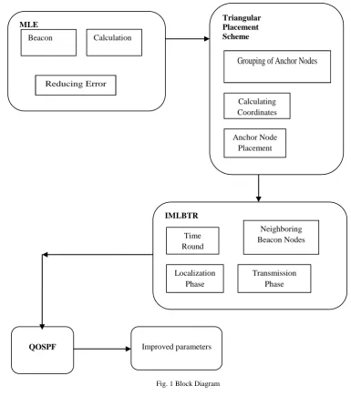
IMLBTR and QoS Multicast Routing Protocol are as follows. The block diagram for the detection of wireless sensor network in the wild area is shown below figure 1
Fig. 1 Block Diagram
1. THE ITERATIVE MUTILATERAL LOCALIZATION BASED ON TIME ROUNDS
The sensor nodes are static once they are placed. Each node supports a range estimation technique, to estimate their neighbouring nodes. The network region for the mapping of anchor nodes can be mapped.
A. MAXIMUM LIKELIHOOD ESTIMATION TECHNIQUE
The IMLBTR uses Maximum likelihood estimation (MLE) to calculate the unknown node coordinates. The principle of MLE as follows:
If an unknown node has n (n≥3) neighbouring beacons, it use these beacon coordinates to estimate its coordinates. Let (x, y) represents the unknown nodes coordinates: (xi, yi) (1≤i≤n) represents coordinates of its ith neighbouring node, di (1≤i≤n) represents the distance between the unknown node and the ith neighbouring beacon node. According to Euclidean distance formula non linear equations are formulated as
QOSPF Improved parameters
Triangular Placement Scheme
Grouping of Anchor Nodes
Calculating Coordinates
Anchor Node Placement
MLE
Beacon Calculation
Reducing Error
IMLBTR
Time Round
Neighboring Beacon Nodes
Localization Phase
(x-x1)2 + (y-y1)2 =d12
(x-x2)2 + (y-y2)2 =d22 ……….
(x-xn)2 + (y-yn)2 =dn2
B. THE TRIANGULAR PLACEMENT SCHEME OF ANCHOR NODES
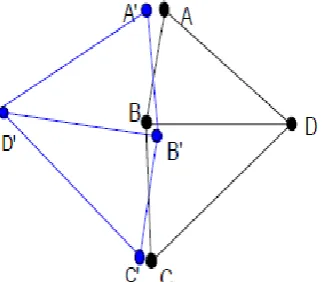
Anchor nodes are expensive resources in WSN. If they are deployed randomly in the network region, their utilization rate is very low. Therefore it is necessary to place anchor nodes elaborately. The idea of triangular placement of anchors comes from two aspects. Due to a small number of anchors, if they are placed randomly in the network region, the probability that the unknown node has three or more neighbouring anchor nodes can be localized directly by using anchors. As a result grouping of anchors take place. Each group consist of three anchors forms an equilateral triangle to place into network region. The size of triangular area should assure that some unknown node can communicate with all anchors in the group so that they can use these anchors to localize directly. Inorder to reduce the error accumulation, it should reduce the number of iterations. Considering a triangular region in figure 1, it is divided into four sub-regions A, B, C and D. In triangle placement scheme figure 2.a, three group anchors are placed in region A, B, C, unknown node in region D can be localized by applying beacon nodes, which are localized in region A, B, C. Whereas in non-triangle placement scheme figure 2.b, three group anchors are placed in region A, C, D and unknown node in region B can be localized only by applying beacon nodes which are localized in region D. Obviously, the average number of iteration that unknown nodes require in region D in triangle placement scheme is less than that in region B in triangle placement. Therefore the average localization error in triangle placement is lower than in non-triangle placement.
a.Triangle Placement Scheme
b. Non-Triangle Placement Scheme Fig. 2 Anchor Node Placement Scheme
C. OVERVIEW OF IMLBTR
larger the error accumulations. Inorder to reduce the error accumulations, use beacon nodes whose iterations are fewer as possible to localize unknown nodes.
Fig. 3 Abnormal Phenomena of Trilateral Localization
After all nodes have been deployed, they first execute some initial operations, such as synchronizing system time, applying a range estimation techniques to estimate the distances between neighbouring nodes, setting system parameters, and so on. Next all nodes start the localization algorithm at the same time. IMLBTR introduces, time round scheme, localizes round after round and it limits the minimum number of neighbouring beacon nodes that localization requires in different time round. Each round is divided into two phases: The first phase is localizing phase, all unknown nodes, which the number of their neighbouring beacon nodes equal to or more than the requirement in this round, are localized. The second phase is location data transmission phase, all nodes which are localized in this round send their own data to their neighbouring nodes.
In the first round, localizing based on anchors, all unknown nodes, whose neighbour nodes have three or more anchors, are localized. Upon an unknown node has been localized, it became a beacon node and send its own location data to its neighbouring nodes. In subsequent each round, localizing based on beacon nodes all eligible unknown nodes are localized, it becomes a beacon node and sends its own location data to its neighbouring nodes. By using time round scheme, IMLBTR assures that unknown nodes are localized by beacon nodes whose iterations are fewer as possible, therefore it reduces error accumulations. Additionally it limits the minimum number of beacon nodes that localization requires in different time round so as to use multilateral instead of trilateral localization to reduce localization error and prevent abnormal phenomena.
D.ALGORITHM
Input: Neighbouring list with neighbouring nodes’ id and distance Output: the location of this node
set Rounds 0
set n[i] neighbouur _ list set a anchor
set c[i] current _ node proc LocationTimer { } {
incr Rounds }
if {c[i] == anchor} {
set $n[i] [$val (x), $val (y)]; stop timer ( );
}
{
calculate (minBS); count (beacon); }
if (beacon >= mimBS) {
calculate (location);
$n[$i] <= [$val9x), $val(y)]; stop timer ( );
} else { next }
2. QoS MULTICAST ROUTING PROTOCOL/MQOSPF
QOSPF is a well-known link state based unicast QoS routing protocol. A simple multicast extension version of QOSPF protocol named QoS Multicast Routing Protocol which uses a scope-limited advertising scheme to limit both control and storage over head as well as delay and it improve parameters such as accuracy, throughput, energy efficiency, packet delivery ratio and life time. Through extensive simulations, it excellent performances on low routing latency, high success rate to find a feasible attachment path to existing multicast node and to construct low cost multicast delivery nodes.
Some assumptions of MQOSPF are given below: (i) Each router can keep track on the local topology information including available link bandwidth and links delay on each of its outgoing link. (ii) A link state based scheme exists to advertise network states. (iii) A QOSPF like scheme exists, which can precompute unicast RIB table. (iv) A Bellman-Ford unicast QoS routing algorithm exists, which is used to precompute all possible available QoS paths. A QMRP search scheme exists, which can search feasible route on demand. The four parts of MQOSPF are:
A.LOOKUP THE BEST FEASIBLE PATH FOR A JOIN REQUEST
If a router c wants to join a multicast group g associated with QoS requirements (∆b, ∆d). It first checks whether the M[g] entry in its on node state table exists or not. If M[g] entry exists, it looks up all the feasible path pi
from its RIB table for each node n€ M[g] and selects the best path among those chosen feasible path by widest-shortest path selection criterion. Then a join procedure is triggered, which will send a JOIN packet to graft the existing multicast delivery node along the selected path. If no feasible path selected, a probing procedure is triggered, which will send a PROBE packet to search feasible join path via QMPR search.
B.QMPR SEARCH
If an intermediate node in the probing procedure, which receives a PROBE packet, is an on node, then it will send a RJOIN packet backward to join reversely along the search path towards the new member node. If no feasible next hop can be found then it triggers the QMRP’s backtracking procedure by sending a NACK packet backward.
C.SET UP FORWARDING STATE ANDADVERTISE LSA
Up on receiving either JOIN or RJOIN packet at a router, it will setup multicast forwarding state to pin the new attachment path. Besides a link state advertising procedure is triggered to distribute the on node state information to each node with in local scope of network centered at this router.
D.RIB PRECOMPUTATION
The advertised on node LSA is used to update the on node state table in the topology data base of each router within the local scope of the network. When the on node state table is updated in the router, then its RIB table will be precomputed via Bellman-Ford Algorithm, which is called event triggered. If the amount of received QoS LSAs across a predefined threshold then the RIB precomputation will also be triggered, this is called threshold trigger.
IV EXPERIMENTAL RESULTS
throughput, energy efficiency, packet delivery ratio and life time as well as decrease in parameters like overhead and delay helps to detect a sensor which is deployed in the wild area, with dense canopies in an effective manner.
V CONCLUSION
An Iterative multilateral localization based on time rounds for wireless sensor network was proposed. It uses triangular placement and time round scheme to reduce error accumulation caused by iterative localization, and limits the minimum number of beacon nodes that localization requires in each time rounds to reduce localization errors and to prevent abnormal phenomena caused by trilateral localization. Consequently in large error ranges it can achieve good localization results. This algorithm is an efficient range based localization algorithm and is applicable to RSSI-based range techniques. Existing methodology CDL is compared with IMLBTR and an optimal output is obtained. By using QoS Multicast Routing Protocol/MQOSPF the parameters such as accuracy, throughput, energy efficiency, packet delivery ratio, overhead, life time and delay are improved.
REFERENCES
[1] N. Bulusu, J. Heidemann and D. Estrin, “GPRS less low cost outdoor localization for very small devices,” IEEE Pers. Commun., vol. 7, no.5 pp..28-34, Oct 2000.
[2] T. He, C. Huang, B. Blum, J. Stankovic and T. Abdelzaher, “Range free localization scheme for large scale sensor networks,” in Proc. ACM
MobiCom, pp. 81-95,2003.
[3] L. Jian, Z.Yang, and Y.Liu “Beyond triangle inequality: Sifting noisy and outlier distance measurements for localization,” in Proc. IEEE
INFOCOM, pp. 1-9,2010.
[4] H. Kung, C. Lin, T. Lin and D. vlah,“Localization with snap-inducing shaped residuals (SISR): Coping with errors in measurement,” in Proc.
ACM MobiCom, pp. 333-344, 2009.
[5] T. Ledermann “Evaluating the performance of semi-distance-independent competition indices in predicting the basal area growth of individual trees,” Can. J. Forest Res., vol. 40, no. 4 pp.796- 805, 2010.
[6] M. Li and Y. Li, “Rendered path: Range free localization in anisotropic sensor networks with holes,” IEEE/ACM Trans. Netw., vol. 18, no. 1, pp. 320-332, Feb. 2012.
[7] Z. Yang, Y. Liu, “Quality of trilateration: Confidence-based iterative localization,” IEEE Trans. Parallel Distrib. Syst., vol. 21 no. 5, pp. 631-640, May 2010.
[8] Z. Zhong and T. He, “Achieving range free localization beyond connectivity,” in Proc.ACM SenSys, pp. 281-294, 2009.
BIOGRAPHY
IRIN KURIAN
She was born on May 19, 1990 in Kottayam, Kerala, India. She received B.E degree in Electronics and Communication Engineering from CMS College of Engineering, Namakkal, Tamil Nadu, Anna University, in 2012. She is currently doing the Post-graduation in VLSI Design And Embedded Systems from Hindusthan Institute of Technology, Coimbatore, Tamil Nadu, Anna University, now working on a research project in Wireless Sensor Networks.
S. KAVITHA