Implementation of GIS Technology for Cost
and Time Effective Material Management and
Supplier Selection
Rashmi P. Rana1,*, Dr. Ganesh A. Hinge1
Department of Civil Engineering, TSSM’s BSCOER, Pune, India1
ABSTRACT: This paper demonstrates a study on applying an integrated Geographical Information System (GIS) technology to support decision making based on material management and supplier selection during construction process. The simple step of selecting suppliers during construction if done improperly leads to major problems in terms of delivery, cost, quality and availability of materials on time which may adversely affect the overall construction project. In this study the capability of GIS software to deal with spatial data with the help of database management tool is been highlighted and thus simplifying the decision of supplier selection by giving optimized results with help of spatial data query and network analysis. Case study results indicate that the proposed system can prove to be beneficial in reducing project time delays and cost overruns.
KEYWORDS: Supplier selection; Material management; Geographical Information System (GIS); Decision making
I. INTRODUCTION
The discipline of project management is often ill defined particularly when it comes to site operations including supplier selection and material procurement [1]. There is a considerable knowledge about the things that go wrong and the consequences of ineffective decision making, but there is limited published information about what
procedures and step to follow to avoid cost overruns and time delays. This is particularly true
of site material management practices [2]. Material management plays an important role in construction industry and in order to select most ideal material in the required time, there is a need of best material supplier. Thus the use of computer based information system may help in reducing the redundancy as well as saving time and cost [3].
1.Scope and Objective
The scope of this paper is to develop a GIS map of thane city, data collection and categorization of suppliers/dealers of major construction materials and integration using GIS Software. The objective of this paper is to collect data of suppliers, develop GIS map and integrate data into it. Further the time and cost involved in material management can be reduced using GIS based tool. The concept of supplier selection is given less importance in construction industry which creates problem of non-availability of materials on time. Eventually it affects duration and cost of the project. To address this issue by way of disciplined site project management, GIS can be effectively employed.
II. LITERATURE REVIEW
This paper reports the development of geographical information system for easement of supplier selection process; this section covers the overview of GIS, traditional method of supplier selection process and basic concept of material management.
1.1. Geographical Information System (GIS)
abilities to handle spatial information from scales and any sources. Exploring geographical information system is needed as the database is the essential part of any information system employed for construction management. GIS activity can be grouped into spatial data input, attribute data management, data display, data exploration, data analysis and GIS modelling [4]. GIS stores the information about the world as a collection of thematic layers that can be linked together by geography. This simple but extremely powerful and versatile concept has proven valuable for solving real world problems from modelling global atmospheric circulation, to predicting rural land use, and monitoring changes in rain forest ecosystems [5].Understanding the role of GIS in data management and integration, data analysis and data visualization is essential in order to get the required results for this study.
2.1.1. Data management and Integration
A traditional GIS consist of a well known layer based architecture in which each layer denotes a single theme in a particular area. Although these layers seem to be separated, they are connected via a coordinate system. GIS differs from other information system with its own data indexing system. Queries based on the locations of the features can be solved with GIS. Data management in GIS facilitates spatial queries and analyses that are impossible in other information system [6].
2.1.2. Spatial data query and analysis
Selective display and retrieval of information from a database are among the fundamental requirement of GIS. Data base query selectively retrieving information from already stored data. Raster and vector data both can be queried. In this study we already converted the collected raster data into vector file, thus will give attention on solving of vector data query. There are two types of query that GIS generally allows on vector data that are query by attribute data and by spatial data. As we have already prepared the attribute table with the help of data collected during this study, so we will solve queries by attribute data. GIS software includes the structured query language (SQL) to search a GIS data base. Simple to more complex queries can be made with the help of SQL. GIS with its abilities to solve multiple condition queries not only save time and money in labor-intensive tasks but also is a significance tool in supporting decision-making over the space [6].
2.1.3. Network analysis
Network models are based on interconnecting logical components, of which the most important are ‘Nodes’ defines start, end and intersections and ‘Chains’ are line features joining nodes that describes the middle line of a network feature, such as road centre line. Chains and nodes are discretely referenced by co-ordinates [7]. Network analysis helps to find the optimal way to transport resources from one location to another location in the network. Network is essential in order to represent natural and cultural phenomena in the real world [6]. Dijkstra’s algorithm is the most well-known approach to calculate the shortest path between two points in the network [8].
21.4. Geovisualization
Geovisualization refers to techniques and tools designed to interactively ‘visualize’ spatial phenomena. This term is about the presentation of data by maps, digital images, vector data and virtual reality in soft or hard copies. A GIS includes interactive maps and other views that operate on the geographic data sets. Maps are useful in conveying geographic information as well as to perform numerous tasks, including analysis, querying and field data collection. MacEachren (1995) used the term geographic visualization’ to describe the use of maps for setting up a context for visual information processing, which can then lead to formulation of research questions and thus not only intended to visual representation rather a geospatial analysis [9].
2.2 Supplier Selection
2.2.1. Critical success factors for supplier selection
There are some important factors that should be considered for selection of suppliers that are listed as follows [11]: Quality of materials
Quantity of materials Price of materials Availability of materials Delivery service Technical capability Financial strength Geographical location Reputation
Management and organization Other factors.
2.2.1. Significant steps for supplier selection
There are seven different steps on the basis of which selection of suppliers is being carried out.
The seven steps are listed below [10].
Step 1 - Identification of the need for a specific product Step 2 - Identify key sourcing requirements and criteria Step 3 - Determine sourcing strategy Step 4 - Identify potential supply sources
Step 5 - Limit suppliers in selection pool Step 6 - Determine method for final selection Step 7 - Select suppliers and reach agreement
2.3. Material Management
Material management is the technique by which the firm is supplied with the goods and services that meets its objectives of buying, storage and movement of materials. The main purpose of material management is to ensure the accessibility of construction materials at their point of use when needed. Hence effective material procurement plays a key role in the successful completion of the work. Thus materials management is the system for planning and controlling in order to ensure that the correct quality and quantity of materials are properly specified in a timely manner, are obtained at a reasonable cost and are available at the required time. Proper management of procuring materials is critical and should be done carefully as any materials surpluses or shortages will delay the project and hence affects the overall project costs. Efficient material management results in substantial savings in project cost.
III. CASE STUDY DESCRIPTION
A. Study Region- Thane city
Thane city is one of Maharashtra’s major industrial towns and is a metropolitan city. The population of city is around 1,818,872 pegged by The National Decennial Census 2011. Thane City is geographically spreads over an area of 128.23sq.km. Thane City lies in the co-ordinates 19.2183° N, 72.9781° E.
B. Data Acquisition
1.2. Scope of case study
The activity reported in this case study is framed into five sub activities, geo-registration of thane city map, developing of city map showing boundary, roads and railways network, Integration of data collected from various suppliers into developed map, solving single as well as multi conditional queries and finally performing network analysis on selected suppliers for getting cost effective and time saving results.
1.3. Implementation of GIS model 4.2.1. Procedure for database generation
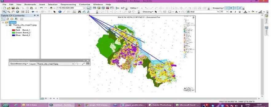
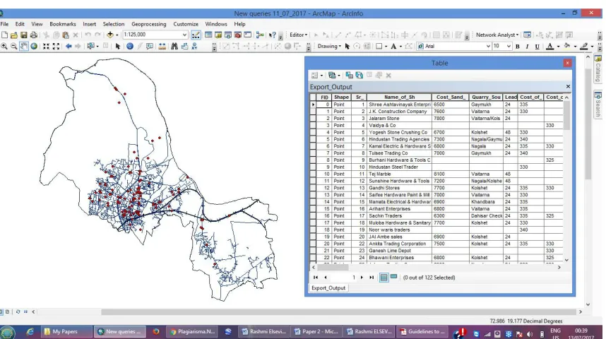
As GIS handles both spatial and attribute data, spatial data represents geometry of the features, while attribute data is stored in the tabular form and describes the characteristics of the different features. In this paper an attempt is made to utilize this aspect of GIS for storing, quarrying, analysing and displaying geographic data. Fig. 1 shows geo-registration of thane city map and Fig. 2 exhibits three different layers with table creation of suppliers data. The step-wise procedure followed for its effective use in this case study is mentioned below [12]:
1. Geo-registering of Thane city map Step 1: Create Thane city map file Step 2: Open image file of Thane city map Step 3: Add the tic marks to registered the map Step 4: Calculate error
2. Create different Layers in Thane city map
External boundary layer of Thane city – Polygon Layer
Roads network and Railway line Layers of Thane city – Segment Layer Suppliers location Layer in Thane city – Point Layer
3. Digitization of all layers 4. Editing map
5. Polygon formation 6.Table creation of suppliers location layer
7. Preparation of Data base of suppliers data
Fig. 2. Digitized map shows suppliers location, Thane city boundary layer, railway and road lines and table creation of suppliers data.
4.2.2. Generation of queries
The database file of Thane city map is used in GIS. Spatial data query module basically used for running query and find out best solution. It allows you to define a spatial query against SQL spatial types in a spatial database to create a layer (query layer) that can be viewed and queried. Vector query is very important to Thane city map vector file. By running query find the appropriate solution which will provide ease for supplier selection process. With the help of this query find out minimum cost of materials, available stock, lead time etc. in very few time. Also it facilitates comparison of more suppliers and evaluation of each supplier. Fig. 3,4and 5 shows the detail of three queries resulted from single and multiple conditions.
4.2.2.1 Query No.1
Fig. 3. Detail of Query No.1.
4.2.2.2 Query No.2
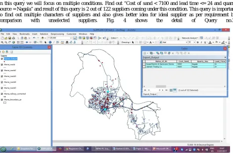
In this query we will focus on multiple conditions. Find out “Cost of sand < 7100 and lead time <= 24 and quarry source = Nagala” and result of this query is 2 out of 122 suppliers coming under this condition. This query is important to find out multiple characters of suppliers and also gives better idea for ideal supplier as per requirement by comparison with unselected suppliers. Fig. 4 shows the detail of Query no.2.
4.2.2.3 Query No.3
Find out detail information of any one supplier in one click for this condition of query is “Name of shop = J K construction” and result of this query shows exactly that supplier with location and all detail information. This query saves time in searching of an individual supplier data from different saved files, the normal procedure followed during traditional method of supplier selection. Fig. 5 shows the detail of Query no.3.
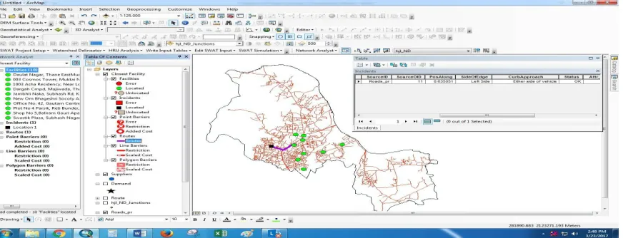
Fig. 5. Detail of Query No.3. 4.2.3. Network Analysis
This paper has utilised this analysis to locate the shortest route between the construction site and suppliers location and also for finding the nearest supplier among the selected suppliers thus gives best results in very short time and simplifies
Fig. 6. Image showing shortest route between construction site and suppliers location.
Fig. 7. Image showing nearest suppliers location among the selected suppliers location from construction site.
IV. RESULT
Collection of suppliers data for evaluation and analysis of supplier selection is a tedious task in comparison to data management tool in GIS. Spatial data queries gives useful results as per the requirement and conditions in a very short time.
Network analysis helps in taking optimum decision by finding the shortest route between source and destination thus reducing transportation cost as well as selecting the nearest and best supplier. The obtained results proves GIS as a remarkable and user friendly tool in supporting decision making for this case study.
V. CONCLUSION
material management techniques leads to reduction of time and cost overruns. In today’s scenario Construction Company is in search for a tool which is interactive, reliable and affordable in order to make the appropriate decisions. This study proves that GIS can be considered as one of the significant information system meeting the present needs of the real world. This is anticipated that GIS and systems with similar functionality open the wider option in future material management and supplier selection practices.
REFERENCES
[1] H.Randolph Thomas, Riley D.R., Messner J.I., 2005. Fundamental Principles of Site Material Management. Journal of construction Engineering and Management, 131(7), pp. 808-815. doi: 10.1061/(ASCE)0733-9364.
[2] Thomas, H. R., Sanvido, V. E., Sanders, 1989. Impact of material management on productivity- A case study. Journal of construction Engineering and Management, 115(3), pp. 370-384. doi: 10.1061/(ASCE)0733-9364.
[3] K.V. Patel, Prof. Chetna M. Vyas, 2011. Construction Materials Management on Project Sites. National Conference on Recent Trends in Engineering and Technology, Gujarat, India. pp. 1-5.
[4] Clark, K., 2011. Getting started with Geographic Information Systems, 5th edn., Pearson Education, 369pp.
[5] Kang- Tsung Chang, 2006. Introduction to Geographic Information Systems, 4th edn., McGraw- Hill Higher Education, University of Michigan, 450pp.
[6] Heng Li, C.W.Kong, 2003. Internet-Based GIS System for E-Commerce Application in Construction Material Procurement. Journal of construction Engineering and Management, 129(6), pp. 689-697. doi: 10.1061/(ASCE)0733-9364.
[7] Basudeb Bhatta, 2011. Remote Sensing and GIS, 2nd edn., Oxford University Press, New Delhi, 716pp.
[8] Dijkatra, E.W. 1959. A Note on Two Problems in Connection with Graphs. Journal of Numerische Mathematic, 1(1), pp. 269-271. doi: 10.1007/BF01386390.
[9] MacEachren, A.M. 1995. How Map Works: Representation, Visualization and Design, Guildford Press, New York, 513pp.
[10] Mendoza A., 2007. Effective Methodologies for Supplier Selection and Order Quantity Allocation. Ph.D. Dissertation, The Pennsylvania State University, Pennsylvania, 163pp.
[11] Yong L., Qi W., 2012. Case study of optimal material supplier selection by the Value Engineering Theory. Key Engineering Materials, pp. 887-891.
[12] Don Amila Sajeevan Samarasinghe, John E Tookey, James Olabode Bamidele Rotimi, and Sivadass Thiruchelvam, 2012. Supplier Selection in the Construction Material Purchasing Function. In: Proceedings of the 4th Annual American Business Research Conference, World Business Institute. pp. 1-14,
http://www.wbiconpro.com/512-Amila.pdf
[13] Thakare P.V., Mhaske S.Y., 2014. GIS based Material Management and Supplier selection- A Case Study. International Journal of Innovative Research in Advanced Engineering, 1(5), pp. 48-53.