R E S E A R C H
Open Access
Optimized combination model and algorithm of
parking guidance information configuration
Zhenyu Mei
1*and Ye Tian
2Abstract
Operators of parking guidance and information (PGI) systems often have difficulty in providing the best car park availability information to drivers in periods of high demand. A new PGI configuration model based on the optimized combination method was proposed by analyzing of parking choice behavior. This article first describes a parking choice behavioral model incorporating drivers perceptions of waiting times at car parks based on PGI signs. This model was used to predict the influence of PGI signs on the overall performance of the traffic system. Then relationships were developed for estimating the arrival rates at car parks based on driver characteristics, car park attributes as well as the car park availability information displayed on PGI signs. A mathematical program was formulated to determine the optimal display PGI sign configuration to minimize total travel time. A genetic algorithm was used to identify solutions that significantly reduced queue lengths and total travel time compared with existing practices. These procedures were applied to an existing PGI system operating in Deqing Town and Xiuning City. Significant reductions in total travel time of parking vehicles with PGI being configured. This would reduce traffic congestion and lead to various environmental benefits.
Keywords:parking guidance information, parking choice, optimized display model, genetic algorithm
1. Introduction
Intelligent transportation systems (ITS) can significantly alleviate the problems of congestion, pollution, and acci-dents within an urban centre, by releasing the real-time traffic information to drivers. Parking guidance informa-tion system (PGIS) is one of ITS applicainforma-tions, which dis-plays the information about the direction to and availability of parking spaces to reduce the time finding available spaces as well as the queuing time during peak period relying on the variable message signs (VMS) [1-4]. Recent advances in the development of wireless vehicular networks have become a cornerstone of ITS. Security is a fundamental issue for vehicular networks since without security protection ITS communication does not work properly [5,6]. For large parking lots, through Wireless sensor networks and vehicular communication, a new smart parking scheme were proposed for providing the drivers with real-time parking navigation service,
intelligent antitheft protection, and friendly parking infor-mation dissemination [7-10].
In most large cities in China, parking guidance sign boards have been set for displaying parking information. Parking guidance signs, as a method of mass guidance strategy, can display the name, parking space occupancy, and driving direction to car parks for drivers. But whether the car park information leads to better effect, and how to depict the best car park availability information to drivers are still under research in China [11,12].
In the recent researches and applications of PGIS around the world, it is commonly used to display the same parking information for vehicles coming from different directions. Although this method can truly reflect the utili-zation of the parking spaces in the monitored areas, there still exists a problem that the drivers coming from differ-ent directions are likely to behave all the same with each other [13-15]. So how to determine the best availability status to display on the signs is becoming a common pro-blem. This particularly relates to periods where demand levels are approaching capacity. Since signs are generally located some distance from car parks, PGI system * Correspondence: [email protected]
1
Department of Civil Engineering, Zhejiang University, Hangzhou, 310058, China
Full list of author information is available at the end of the article
operators must determine when to display FULL for car parks before their utilization has reached capacity.
2. System analyses
When there is no parking guidance system, the driver would select the parking spaces based on his own demand and judgment. If it comes to the popular park-ing spaces within the urban area, drivers are likely to make the similar decisions. This situation will lead the parking demand to exceed the parking capacity. Mean-while, too many vehicles searching for parking spaces will cause traffic congestion in peak time.
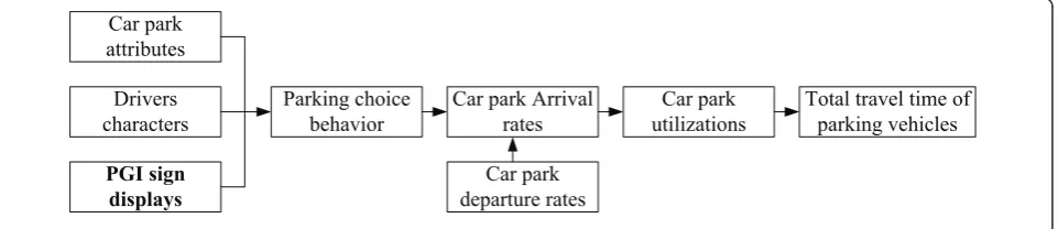
The temporal utilization of car parks is influenced by the arrival and departure rates of vehicles. Drivers’choice beha-vior is influenced by driver characteristics as well as the attributes of car parks and PGI signs. The optimized model of PGIS configuration is based on the real parking supply and demand conditions to display optimized parking infor-mation on VMS to influence the performance of parking system in central city. Figure 1 describes how the total tra-vel time of vehicles is estimated based on the drivers’ park-ing choice behavior and predicted arrival rates at car parks.
Since the optimized model of PGIS configuration con-siders the parking choice behavior, the following assumptions were made to provide simplistic representa-tion of the model.
(1) All the parking spaces are off-street. (2) There is no illegal parking.
(3) If the drivers observe the PGI sign board, they will make their parking choice at the location of the sign boards.
3. Parking choice behavior model
From the perspective of Microeconomics, the parking space chosen is determined by the impedance of the parking spaces. The drivers will always choose the park-ing space with the lowest impedance, which is related to the consumed time and cost [11,16-18]. The time
con-sumed includes trip time Tm, waiting time Tw, and
access time Ta. The cost is mainly the parking fee p.
The total parking utilityUis calculated as
U(Tm,Tw,Ta,p) =αTm+βTw+γTa+μp(t) +τi (1) where a,b, g,μ, τare all utility parameters. Tm is the
time consumed for the in-vehicle traveling from the location of VMS to the parking space.Twis the queuing
time before entering the park.Ta is the walk time from
the parking set to the destination.p(t) is related to the parking price and the expected parking duration.
The length from the location of VMS to the parking space is the nearest network distance. The average speed is related to the road impedance function and can be calculated by the BPR function proposed by the U.S. Federal Highway Administration [14]. The trip time is calculated as
whereLm is the distance from the location of VMS to
the parking space, km; νm is the average speed of the
vehicle, km/h; qiroad traffic flow, pcu/h; Ciis the road
capability, pcu/h;ν0 is the free-flow speed, km/h;ωi,i
are all model parameters;i= 1, 2 stands for motor vehi-cles and non-motor vehivehi-cles.
The access time refers to the walk time from the park-ing space to the destination. It can be calculated based on the average distance from the parking space to the activity spot and the average walk speed can be calcu-lated by
Ta=
la
va
(3)
wherelais the distance from the parking to the
activ-ity spot, km;νais the average walk speed, km/h.
Though there are various possibilities for parking behavior, it is always expected to choose the best (with the lowest impedance) parking space. From the view of drivers, under the normal condition of parking areas, the parking spaces with certain location, convenient ser-vice, short distance to the destination and acceptable waiting time are likely to attract more vehicles [19,20].
Car park
Car park Arrival rates
Car park departure rates
Car park utilizations
Total travel time of parking vehicles
A constant perceived waiting time is assumed at car parks for drivers observing the PGI signs displaying car parks to be unavailable. Drivers not observing the PGI signs are also assumed to perceive a constant waiting time at car parks having a high utilization (e.g., above 95%). These drivers are having information regarding the actual utilization of car parks.
Thus, assuming that a set of drivers selecting parking spacej in zonekfrom the location VMSi, the parking choice model of having observing PGI signs can be con-structed as
wherePijkis the probability to select parking space j from locationito destination zone kwith having obser-ving PGI signs;Uijk(Tm,Tw,Ta, p) is the utility function
of parking spacej, %;θis a scale parameter. Here,
Tw=
C, if PGI sign board displays car parkjnot available in [St,St+1],
0, otherwise (5)
Stis the start of time intervaltandSt+1is the start of
time interval t + 1, where C is the perceived waiting
time at car park (min).
The parking choice model of having not observing PGI signs can be constructed as,
P0
ijk is the probability to select parking spacej
from location i to destination zone with having not
observing PGI signs. Here,
Tw=
C, ifUj>F, at timeDl
0, otherwise , (7)
whereUjis the utility of car parkj at timeDl (%),F the non-observers utility threshold (%), and Dl is the time that the PGI display configuration for interval lis determined.
4. Parking arrivals dynamic estimation
The model developed here assumes that the availability status of car parks displayed on the PGI signs is con-stant for small time intervals (e.g., 5 or 10 min). The arrival of vehicles at car parks must be predicted for three separate periods (Figure 2).
During the first period, the arrival rate in park j is constant and equals to the existing rate experienced when the display configuration was determined. Assume drivers make decision at the time Dl, reach the PGI sign
i at the time Sl, This rate is assumed to continue until
vehicles begin arriving at car parks after observing the new configuration that has been determined. This involves determining the minimum travel time from signs to car parks.
For the second period, from the timeSl+min{tij}, the arrival rate is dually influenced by the last display con-figuration and the determined one because of the differ-ent travel times from the signs to car parks in the network, till the timeSi+ max{tij}.
For the third period, from the time Si+ max{tij} toSl
+1 + min{tij}, the arrival rate at parking lot j is only
influenced by the current dispay configuration. This per-iod terminates when it is possible for vehicles to arrive at a car park after observing the next display configura-tion after the one to be determined.
rj(t) = the probability did not observe PGI sign board and txij is sequenced from lesser to greater, x= 1,2,...,I.qij is the
parking flow rate from deciding nodeito parkj. Therefore, the total amount of arriving parking vehi-cles can be calculated as:
Rj(t) = Dl+t
Dl
rj(t)dt. (9)
5. Parking guidance model
To implicate the parking guidance configuration strate-gies, an objective function should be determined and a mathematical optimized model should be constructed. Comparing to the conventional parking without the parking guidance, the advantage of parking guidance can be shown clearly as following. The origin of the model is to get the shortest vehicle kilometers of travel (time) in urban area to get to the first choice parking space. Usually, the total travel timeTis easy to get and it can represent the meaning of vehicle kilometers of travel [21]. Thus,T is regarded as the decision variable in this article. For parking spacej, the objective function can be built as follow:
Min.T=TmRj(l) (10)
where Tm is the time consumed from location i to
destination zonekin time l, veh/h; lis the time interval of the status displayed on VMS, min.
The real-time utilization of parking spaces can be divided into‘F’(Full) and‘E’(Empty) where‘F’represents the parking space is full and‘E’represents the parking space is still available as well as the number of parking sets available displayed on the VMS. Considering Equa-tions 810, we can find that the objective function Tis influenced byPijkdirectly and can influence the parking
choice through the status displayed on VMS. Its nature is to get the optimized value of objective function through the configuration of the status displayed on VMS. For the status displayed on VMS in each display interval, the fol-lowing‘configuration optimization method’is proposed to demonstrate how it works.
Whenjparking spaces are available,Isigns display‘F’ or‘E’randomly. The same parking space would have dif-ferent status in difdif-ferent zone. Thus, the final optimiza-tion results obtained through continuous iterative calculation based on the method. The constrained condi-tions are as follows:
δijk=
⎧ ⎪ ⎪ ⎪ ⎨ ⎪ ⎪ ⎪ ⎩
0 :τijk= 100%.
0 : depicting car parkjinkdistric unavailable on signi,σj≤τijk<100%. 1 : depicting car parkjinkdistric available on signi,σj≤τijk<100%. 1 : depicting car parkjinkdistric available on signi,τijk< σj.
(11)
whereδijkis a Boolean variable which represents the
utilization of parking space jin zone kfrom signi.τijkis
the utilization of car park.sjis the threshold.
Based on this method, the availability status displayed on each VMS can be determined by Equations 10 and 11 instantaneously.
6. Model algorithm
If each PGI sign board displays the availability status of all parking spaces in this system, there will be 2IJ possi-ble status combinations for each interval. Because of the large amount of possible display configurations and the complexity of the relationships, an accuracy solution
procedure cannot be applied. Thus, an algorithm with a faster convergence speed and more accurate result is very necessary.
Genetic algorithm (GA) is a self-organized and adop-tive artificial intelligent (AI) technology based on the simulation of Darwin’s Biological Evolution Theory and Mendel’s Genetic Variation/Mutation Theory. It can be classified as the configuration search and optimization method. From the eyes of overall optimization, GA does not need to calculate the partial derivative; neither does it need the continuity and differentiability of the opti-mized objects. Compared to the former two, every step in GA makes full use of available status to guide the search procedure, in order to pass on the good informa-tion to the offspring as well as to eliminate the bad information. Besides, GA allows more than one current result during the search time, to obtain good robustness. It can not only enhance the optimization level on numerical results but also get the approximate linear acceleration effect [22,23]. Thus, GA can find the opti-mized result in a reasonable time.
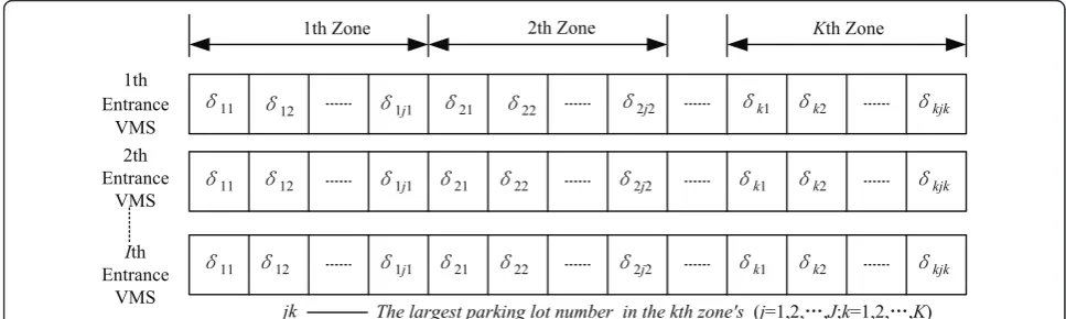
As GA works based on probability while the parking choice probability is influenced by the saturation of parking spaces, according to Equation 11, the availability status displayed on VMS during a specified time interval are coded as the chromosome:
δm=
1 : depicting car park (l/J−[l/J]×Javailable on sign([l/J] + 1)
0 : depicting car park(l/J−[l/J]×Junavailable on sign([l/J] + 1)(m= 1,2,· · ·,IJ) (12)
where [l/J] is an integer less than or equal tol/J. Based on standard genetic algorithm (SGA) and ‘ con-figuration optimization method’, procedures of mortified SGA are implemented;
1. Coding: Binary coding is the simplest coding method. Sinceδmin Equation 12 has two values, 0 or 1, the binary coding is possible. It can make Gene Icon with low rank, short length, and high fitness to generate more offspring. This method speeds up the convergence and agrees with the principle of GA.
Arrival Rate (vpm)
0
. . .
qk
Dl Sl Sl+min{tij} Sl+max{tij} Dl+1 Sl+1 Sl+1+min{tij} Time (minutes)
Sl+tijx
First period Second period Third period
. . .
Since GA cannot address the spatial solution set data, the chromosome variablesδm is first coded as binaries to make them the genetic string structure data in genetic space. When coding, more than one variable can be code, or all variables can be coded into one some to make each variable as a part of the chromo-some. To make the article compact and the presentation
easy, we codej parking spaces in zonek asI
chromo-somes based on the entrance number just like what Fig-ure 3 shows. Each chromosome is a data string composed by 1 and 0.
2. Generate initial solution set: Based on the charac-teristics of GA, for the fixed m(m = 1,2,...,IJ) VMSs’
sta-tus, H = 2IJ initial solution sets are determined
randomly, then N = H initial population can be
obtained. In the model,Nis determined by the number
of parking spaces in the certain zone and the accuracy of solution.
3. Determination of fitness function and calculation of individual fitness: This model aims at the shortest total travel time in certain zone. The fitness function is the objective function in Equation 10.
The constrained conditions are given in Equation 11.
Put N initial populations into Equation 10 and the
related fitness can be get.
During the calculation, the binary coded individual should be decoded as the decimal form in the search space. For example, 10100 should be decoded as 20.
4. Population’s selection and duplication: In order to select good individuals from theN = H initial popu-lations, the probability method which is direct pro-portional to the individual fitness is adopted. The detail procedures are as follows;
○Optimize the initial population for Ntimes, get the individual fitnessfi= min (Ti) (I= 1,2,...,N).
○Calculate out the sum of all the individual fitness
S=Ni=1f.
○ Calculate out the percentage of the value of the
individual is fitness in S.
○ Based on the aim to get the shortest total travel
time, the order of selection probabilityPias the reverse order of fi/S is determined, which means the one with the lowest fitness will get the highest probability to be selected out.
○Based on the selection probability and the number
of population, the duplication is conducted, which means when δj(j= 1,2,...,m)s selection probability isPj,
N × Pj individuals from duplication can be get. The
population with large selection probability will get more choice to be duplicated and those with small selection probability would be eliminated. Because of duplication, the populations in mating pool reduce the average travel time in certain zone. However, no new chromosome is given birth to, leaving the fitness of the best individuals in the population unchanged.
5. Crossover: The detail procedures of crossover are as follows:
○ Pair the δj(j = 1,2,...,m) in the population where there areN = mindividuals randomly.
○Identify the crossover probability Pc, standing for
the percentage of individuals which involves into cross-over. For example, if Pc= 0.5, then half of the
popula-tion are paired and the informapopula-tion is exchanged. The largerPcis the fast the exchanges are and more possible
the good individuals are produced, the fast the speed of convergence is.
○Decide the crossover location in the paired indivi-duals. The paired ones exchange part of the binary information, leaving other parts unchanged. Two new individuals are produced by crossover. Figure 4 shows how single-point crossover works.
Mutation:
¥11 ¥12 ¥1j1 ¥21 ¥22 ¥2j2 ¥k1 ¥k2 ¥kjk
jk The largest parking lot number in the kth zone's (j=1,2,Ă,J;k=1,2,Ă,K)
1th Zone 2th Zone Kth Zone
1th Entrance
VMS
¥11 ¥12 ¥1j1 ¥21 ¥22 ¥2j2 ¥k1 ¥k2 ¥kjk
2th Entrance
VMS
¥11 ¥12 ¥1j1 ¥21 ¥22 ¥2j2 ¥k1 ¥k2 ¥kjk
Ith
Entrance VMS
For mutation, the largerPmis, the more possible the
good individuals are produced. However, algorithm con-vergence would be ineffective; if Pm is too small, then
the variation ability would be bad, which could make the initial population become a same population too early. The value empirically in the suggested range can be selected.
6. Termination: Take the mutated population into step (3) to calculate out the minimum fitness of total travel time in certain zone. Whether the algorithm should be terminated is determined by the principles set above. There are two conditions in which the algorithm can be terminated.
For the fixed m, if there exist an individualδj(1 <j ≤ H) which makes min (T) < min (Tini), then make min
(Tini) = min (T), repeat the selection, crossover and
mutation to conduct the iteration.
The number of offspring has exceeded the minimum times of iterationMset before.
7. Model application
7.1. Example 1
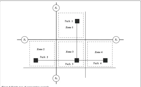
Most cities in China are on the beginning stage of PGIS. This article takes parts of the urban area of Deqing in Zhejiang Province as one example to simulate PGIS. The sketch map and the division of a certain parking zone are showed in the Figure 5. Through the analysis of the popular car park 1, the effects of the optimized model of PGIS configuration can be tested.
In this example, l = 10 min and the average parking
duration of all the vehicles is 1 h. The parking spaces, with the same parking fee for 3 yuan/h, have the capa-city of 100. Take the saturation thresholdτ111=τ333=
τ444 = 80%. Because of the good location, the parking
¥11 ¥12 1 ¥k1 ¥k2 ¥kjk
¥11 ¥12 0 ¥k1 ¥k2 ¥kjk
¥11 ¥12 0 ¥k1 ¥k2 ¥kjk
¥11 ¥12 1 ¥k1 ¥k2 ¥kjk
Randomly selected cross-bit
Figure 4Binary system coding cross operation.
S2 S3
S1
S4
3DUN2
3DUN1
3DUN4 3DUN3
Zone 2
Zone 1
Zone 4 Zone 3
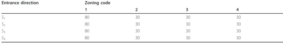
space1 in zone1has the largest attraction for the vehi-cles, with a saturation of above 90% in peak period.qijs
value can be determined by Table 1.
TakeI=J =K= 4, thenN=H= 24 × 4, which means on the 4 VMSs at the entrance in urban area, there exists 216 combinations of status for 4 parking spaces. As the initial population contains the possible maximum combinations, it can guarantee the accuracy. SettingPc
= 0.6, Pm = 0.005, M = 5000. The result is shown in
Table 2.
Based on the table above, it can be concluded that the total travel time is reduced largely when the proposed PGIS is applied, which indicates that total effect of PGIS is better than the condition without PGIS, as is shown in Figure 6.
Min Tappears when there are highτ111(95 to 100%)
and they are above the threshold. In this case, because of the status displayed on the VMS, parts of the drivers do not choose parking space 1 but choose other proper parking spaces, resulting in less vehicles in parking space 1, optimizing the total travel time. After proposed PGIS are applied, under the condition of high saturation of popular parking spaces, the utility of available parking sets can be improved and the parking source can be made full use of.
7.2. Example 2
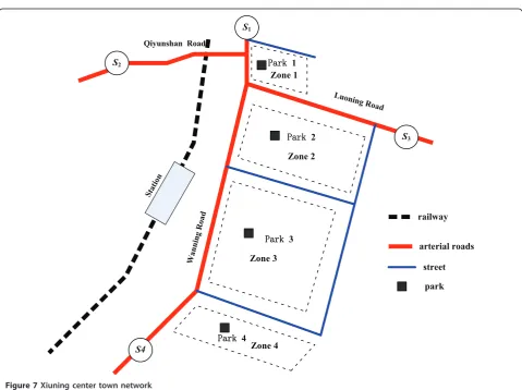
Example 2 is also used to investigate the operational performance of the PGI system for Xiuning City, a regional centre approximately 50 km south of Huang-shan Mountain. The existing PGI system, which was built in 2010, provides availability information for off-street 4 car parks (Figure 7). On-off-street parking is not permitted within the city centre.
Traffic count data from peak period as well as land-use pattern information are land-used to estimate an origin and destination matrix. High volumes are observed entering the city centre from links with PGI signs S1, S2,
and S4. Due to the railway station, high proportion
traf-fic is estimated to have its final destination in zone Z3, with moderate level of demand for zones Z1, Z2, and Z4. All car parks except P3 had approximately 70% utili-zation at the time at which the configuration of signs for the next display interval is determined. All car parks in Xiuning City are off-street with the same fee structure for short-term parking. Estimates of in vehicle travel times and walking times are based on the location of the car parks, traffic, and pedestrian links within the city centre (Figure 7). Each choice parker is assumed to have the same parking duration of 1 h.
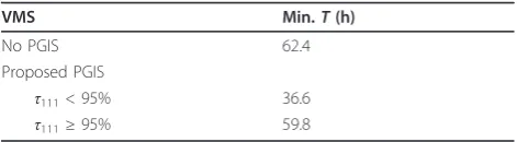
According to the field survey and computation results, the optimization model is able to identify PGI display configurations that substantially reduce the total travel time. The total travel time is estimated to be 36.6 and 59.8 h where the utilization threshold was below and above this level, respectively, which lead to a maximum reduction of approximately 41% (Table 3).
8. Conclusion
This article described procedures that were developed for investigating the effect of PGI sign boards on park-ing choice behavior. An optimized model was able to distribute the exceeding parking demand into proper parking spaces. Through guiding the drivers to choose the proper parking spaces instead of popular ones, the total travel time can be reduced. In this model, some simplify assumptions would perhaps overestimate the effect of PGI sign board on parking choice behavior. In particular, if the observers were not assumed to believe
Table 1 Parks’capacity.
Entrance direction Zoning code
1 2 3 4
S1 80 30 30 30
S2 80 30 30 30
S3 80 30 30 30
S4 80 30 30 30
Table 2 Computation results of park 1.
VMS δ1 δ2 δ3 δ4 MinT(h)
1 2 3 4 2 3 4 1 2 3 4 1 2 3 4
No PGIS - - - - 43.74
Proposed PGIS
τ111< 95% E F F E F F E F F E E F F F E F 23.44
No PGIS W111<95ˁ 95%İW111<100ˁ
Proposed PGIS
T˄h˅
43.74
23.44
22.13
0 20 40
Figure 6The total time T comparisons of no PGIS and proposed PGIS.
S2
S4
S3 S1
3DUN1 Zone 1
3DUN2
Zone 2
3DUN3
Zone 3
3DUN4 Zone 4
railway
Wanning Road
Luoning Road
Qiyunshan Road
Station
arterial roads
street
park
the PGI sign board, the potential of PGIS to influence and manage traffic movement as well as parking choices would be reduced. A similar reduced effect would occur if any illegal parking was considered.
List of abbreviations
AI: artificial intelligent; GA: genetic algorithm; ITS: intelligent transportation systems; PGI: parking guidance and information; PGIS: parking guidance information system; SGA: standard genetic algorithm; VMS: variable message signs.
Acknowledgments
The work is supported by the National Natural Science Foundation of China (no.50908205) and the National High-tech Research and Development Program (863 Program) (no.2011AA110304).
Author details
1Department of Civil Engineering, Zhejiang University, Hangzhou, 310058,
China2Department of Civil Engineering and Engineering Mechanics, University of Arizona, Tucson, AZ 85721, USA
Competing interests
The authors declare that they have no competing interests.
Received: 7 March 2011 Accepted: 19 September 2011 Published: 19 September 2011
References
1. Y Asakura, M Kashiwadani, Evaluation of availability information service by parking choice simulation model, inProceedings of the International Conference on Advanced Technologies in Transportation and Traffic Management, Centre for Transportation Studies, Nanyang Technological University, Singapore, pp. 335–342 (1994)
2. J Polak, I Hilton, K Axhausen, W Young, Parking guidance and information systems: performance and capability. Traffic Eng Control.31(10), 519–524 (1990)
3. R Thompson, A Richardson, A parking search model. Transport Res A.32, 159–170 (1998)
4. F Caicedo,Gestión de aparcamientos subterráneos,Edicions(UPC, Barcelona, 2005)
5. J-H Lee, J Chen, T Ernst, Securing mobile network prefix provisioning for NEMO based vehicular networks. Math Comput Modell (2011) (in press) 6. H Choi, I Kim, J Yoo, Secure and efficient protocol for vehicular ad hoc
network with privacy preservation. EURASIP J Wirel Commun Netw2011, 1–14 (2011)
7. J Chinrungrueng, U Sunantachaikul, S Triamlumlerd, Smart parking: an application of optical wireless sensor network, inProceedings of the the 2007 International Symposium on Applications and the Internet Workshops (SAINTW’07),Hiroshima, Japan 66–69 (January 2007)
8. R Lu, X Lin, H Zhu, X Shen, SPARK: a new VANET-based smart parking scheme for large parking lots, inThe 28th IEEE International Conference on Computer Communications (INFOCOM 2009), Rio de Janeiro, Brazil), pp. 19–25 (April 2009)
9. Y Bi, L Sun, H Zhu, T Yan, Z Luo, A parking management system based on wireless sensor network. Acta Automat Sin.32(6), 968–977 (2006) 10. S Lee, Y Dukhee, G Amitabha, Intelligent parking lot application
usingwireless sensor networks, inProceedings of CTS,Irvine, CA, USA 49–58 (May 2008)
11. Z Mei, Y Xiang, J Chen, W Wang, Optimizing model of curb parking pricing based on parking choice behavior. J Transport Syst Eng Inf Technol.10, 99–104 (2010)
12. B Zhang, K Yan, X Zhou, Optimization of selecting PGI sign locations based on parking guidance behavior survey, inInternational Conference on Transportation Engineering, Proceedings of the First International Conference, Chengdu, China 34–39 (July 2007)
13. R Thompson, K Takada, S Kobayakawa, Optimization of parking guidance and information systems display configurations. Transport Res C.9, 169–85 (2001)
14. H Yan, X Yang, B Yan, Parking choice model study for special events. China J Highway Transport.18, 90–93 (2005)
15. F Caicedo, The use of space availability information in PARC systems to reduce search times in parking facilities. Transport Res C.17, 56–68 (2009). doi:10.1016/j.trc.2008.07.001
16. D Tsamboulas, Parking fare thresholds: a policy tool. Transport Policy.8, 115–124 (2001). doi:10.1016/S0967-070X(00)00040-8
17. D Shoup,The High Cost of Free Parking(American Planning Association, Chicago, 2005)
18. W Marshall, N Garrick, Parking at mixed-use centers in small cities. Transportation Research Record 164–171 (2006)
19. J Oppenlander, Optimal location and sizing of parking facilities. ITE Compendium of Technical Papers1, 4–6 (1988)
20. D Shoup, The trouble with minimum parking requirements. Transport Res A.33, 549–574 (1999)
21. T Rye, K Hunton, S Ison, N Kocak, The role of market research and consultation in developing parking policy. Transport Policy.15, 387–394 (2008). doi:10.1016/j.tranpol.2008.12.005
22. M Zhou, S Sun,The Theory and Application Of Genetic Algorithm(National Defence and Industry Press, Beijing, 2009)
23. S Clement, J Anderson, Traffic signal timing determination, inProceedings of the Second International Conference on Genetic Algorithms in Engineering Systems: Innovations and Applications,Conf. Publ. No. 446, IEE, London, UK 63–68 (1997)
doi:10.1186/1687-1499-2011-104
Cite this article as:Mei and Tian:Optimized combination model and algorithm of parking guidance information configuration.EURASIP
Journal on Wireless Communications and Networking20112011:104.
Submit your manuscript to a
journal and benefi t from:
7Convenient online submission
7 Rigorous peer review
7Immediate publication on acceptance
7 Open access: articles freely available online
7High visibility within the fi eld
7 Retaining the copyright to your article
Submit your next manuscript at 7 springeropen.com
Table 3 Computation results of park 3.
VMS Min.T(h)
No PGIS 62.4
Proposed PGIS
τ111< 95% 36.6