Traffic Management Study for ORR,
Bengaluru Jayadeva Intersection to Silk
Board Intersection
Vani A1 , Madhu Singh2, Dr. Prem Swaroup Reddy M3
Assistant Professor, Department of Civil Engineering, Rajeev Institute of Technology, Hassan, India1
Transport planner, DULT, Bangaluru, India2
Professor, Reva University, Bangaluru, India3
ABSTRACT: One of the well known residential neighbouring hoods in south Bengaluru is BTM Layout. The place is connected by Hosur Road, Bannerghatta Road and Outer Ring Road. The location of BTM Layout is such that it has a good connectivity to many important locations in south Bengaluru such as Jayanagar, Banashankari, J P Nagar, Bannerghatta, Electronic City, Madivala and Koramangala. Because of its location and good connectivity the burden of traffic on the Outer Ring Road (ORR) is very high. Due to the high volumes of vehicular movement frequent delays of long durations are common.The current study was focused on one of the important stretches of ORR between Jayadeva Hospital Intersection and Silk Board Intersection. To assess the congestion issues traffic volume survey and road inventory survey were carried out and it was observed that in addition to the traffic volume being high, poor pedestrian infrastructure and poor road geometry were adding to the traffic woes preventing free flow. From the survey data existing road condition, peak hour traffic, LOS along the study stretch was analysed. Various mitigation measures were identified, the first one being redesigning of the traffic signal timings. A number of trails were done to examine the effectiveness of signal optimization technique using VISSIM – a traffic simulation software. Other recommendations include change in junction design and measures to enhance the pedestrian safety
.
KEYWORDS: Traffic congestion, Traffic surveys, Delay, Queue length, Simulation, Mitigation measures,
I. INTRODUCTION
II. STUDY STRETCH
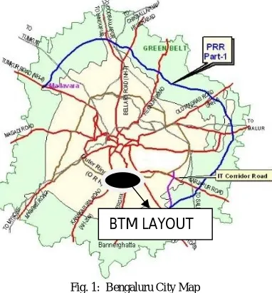
Typical conditions of chaotic urban traffic exists in the area chosen for the present study - BTM Layout. BTM Layout is a well known residential area in south Bengaluru. This area prior to the formation of BTM Layout was known as Kuvempunagara. It has got its abbreviated name as it is situated between Bannerghatta, Tavarekere and Madivala. Fig. 1 shows the map of Bengaluru along with important roads and study area.
Fig. 1: Bengaluru City Map
BTM Layout is located at a distance of 11 km from the central bus stand (Kempegowda Bus Station) and the Bengaluru City railway station. The study area has close proximity to Koramangala, HSR Layout, J P Nagar, Jayanagar, Madivala, Bannerghatta Road and Hosur Road. Also it lies in the vicinity of Electronic City.
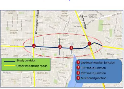
The Outer Ring Road (ORR) separates the 1st Stage of BTM Layout from the 2nd Stage. Because of its location and connectivity to other important areas in the southern part Bengaluru, the traffic on the ORR is very heavy. Keeping this in view the present study was taken up for the stretch between Jayadeva hospital intersection and Silk Board intersection. The length of study stretch is 2.6 km. To assess the congestion issues classified volume count was conducted at the four major intersections along the study stretch namely Jayadeva Hospital Intersection, 16th Main Intersection, 29th Main Intersection and Silk Board Intersection. Fig. 2.shows the important roads and intersections in the study area.
Fig. 2: Major Roads and Intersection along the Study Stretch
Jayadeva Hospital Intersection is a three level grade separated intersection. It has an underpass and a flyover in addition to the at-grade intersection area. The underpass caters to the traffic on the Bannerghatta Road in both the directions. The flyover caters to the traffic entering the intersection from Banashankari and from Bannerghatta and heading towards Silk Board. The at-grade arms of the intersection lead towards Dairy Circle, Silk Board, Bannerghatta National Park and Banashankari.
The 16th Main intersection is a 4 legged at grade intersection with roads leading towards Tavarekere, Silk Board Mico Layout and Jayadeva Hospital.
The 29th Main intersection is 4 legged intersection with roads leading towards Jai Bheema nagar, Silk Board,
N S Palya and Jayadeva hospital.
Silk Board Intersection is 4 legged intersection with roads leading towards Madivala, Agara, Bommanahalli and Jayadeva Hospital. Silk Board Intersection consists of a fly over which caters through traffic from and to Madivala and Bommanahalli.
III. METHODOLOGY
A classified traffic volume count survey and road inventory survey was carried out in the study corridor to analyse the existing traffic scenario throughout the corridor. Existing cycle length and signal phasing at all the intersections was collected for further analysis
The traffic volume data collected was analysed to find out the vehicular composition, turning movements and level of service in each section of study corridor. Since traffic volume count data collected was in different vehicular units it was converted into single unit. Passenger Car Unit (PCU) values as per was used to convert different vehicular units to single vehicular unit. After computing peak hour volume, computation of volume to capacity ratio and level of service (LOS) was done according IRC standards.
V. TRAFFIC SIMULATION
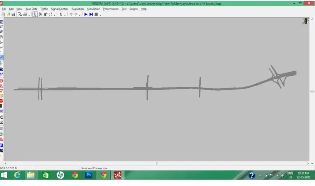
Traffic simulation software VISSIM was used for simulating the data. Both existing and proposed scenarios was simulated using this software to validate the new proposals. The scope of this software ranges from various issues related to traffic engineering, and transport planning. For the creation of network in the vissim it necessary to have a base map of the study area. Base map of study area was created by clubbing various images of study corridor. For creating base map Photoshop software use used. Finally the base in the JEPG format was loaded to vissim software to create a network. Network was drawn by incorporating links and connectors.
The data obtained from field visits and surveys was incorporated to build a model which indicates the existing condition of study corridor. Steps carried out for the preparation of model are listed below;
Building road network- using links and connectors Provision of vehicle inputs to each link
Vehicle composition for overall network Inputs to indicate driving behaviour
Routing options for vehicle along with the vehicular volume in each route Signal Phasing and cycle time for the entire Intersection
Fig. 3: Network building
this output for model was obtained and delay and queue length obtained was cross verified with the field data. Figure 3 shows the typical network building using VISSIM software.
VI. FINDINGS AND RECOMMENDATIONS
After detailed analysis the measures which were best suited for the section was selected. In the following section the mitigation measures adopted in each section is discussed in detail.
Jayadeva Hospital Intersection Issues
1. Absence of dedicated bus stand after the intersection, hence buses are stopping soon after the intersection (towards east end circle).
2. Absence of lane marking and worn out zebra crossing marking at the intersection which fails to indicate specified area for pedestrian crossing.
3. Presence of two table top crossings at an interval of 25m to each other soon after the end of flyover. Table top pedestrian crossing are ineffective in reducing vehicular speed due its gentle slope as well as varying slope (1in 12 to 1 in 20).
4. Narrow footpath at the intersection (0.75m to 1m). 5. Discontinuous footpath.
6. Delay due to merging traffic as well as presence of bus stop at the end of flyover. 7. Traffic congestion, longer queue and delay due to saturated signal phase.
Mitigation measures
1. Shifting of bus stop 120m away from the intersection towards the west to allow free flow of vehicle (east end circle).
2. Zebra crossing marking should be done to indicate the pedestrian crossing area.
3. The second table top crossing should be retained and reconstructed with a slope of 1 in 8 as per guidelines for planning and implementation of pedestrian infrastructure, DULT.
4. Footpath should be kept continuous to increase the pedestrian safety and minimum 1.5m footpath should be provided as per IRC standards.
5. Shifting of bus stop to distance of 120m after the end of flyover to reduce the delay caused because of the existence of bus stop and to allow free flow of vehicle.
6. Sign boards to indicate pedestrian crossing, turning restriction and no parking zone should be installed at the intersection.
7. Redesigning of signal phase to decrease the delay and queue length and to increase the throughput in that section using VISSIM.
3. Width of ORR at 16th Main intersection increased to 22m till a distance of 80m by removing the median between main road and service road.
4. Sign boards to indicate pedestrian crossing, turning restriction and no parking zone should be installed at the intersection.
5. Redesigning of signal should be done to increase the operational efficiency at the intersection.
Existing cycle length-178sec Proposed cycle length-135 sec
29th Main Intersection Issues
1. Absence of dedicated bus stand towards Jayadeva hospital, hence buses are stopping soon after the intersection effecting on free flow of vehicles.
2. Existing bus stop is located at a distance of 40 m after the intersection towards Silk Board effecting on free flow of vehicles during peak hours.
3. No median to separate two way traffic at 29th Main road, which is creating conflicting movement of vehicles causing delay as well as effecting on drivers safety.
4. Width of median (0.7 m) at the approach of intersection is less than IRC standards. 5. Saturated signal phase creating delay and queue length.
Mitigation measures
1. Provision of dedicates bus stand at a distance of 80 m after the intersection towards Jayadeva Hospital. 2. The existing bus stop towards Silk Board should be shifted to a distance of 115m after the intersection to allow
free flow of vehicles.
3. Median on 29th Main road should be constructed to separate two way traffic.
4. Minimum width of 1.2m median on Outer Ring Road (ORR) should be kept which also acts as pedestrian refuge.
5. Sign boards to indicate pedestrian crossing, turning restriction and no parking zone should be installed at the intersection.
6. Redesigning of Signal
Existing cycle length-260 sec Proposed cycle length- 155 sec
Silk Board Intersection Issues
1. Autos were parked on the carriage way reducing the capacity of road and obstructing the pedestrian to access the footpath.
2. Presence of police chowky at the edge of channelizing island (pedestrian refuge) obstructing the way of pedestrian to access the island.
3. Median opening soon after the intersection (toward Agara) creating unnecessary confusion and conflicting movement to merging traffic from/to service lane.
4. Width of footpath (0.6m) constructed over open drain is less making it difficult for pedestrians to access the footpath.
5. U turning traffic just before the Intersection conflicting to through traffic, affecting on free flow of vehicles. 6. Width of median is getting reduced to 0.7 m which is not as per IRC standards.
7. Insufficient turning radius for the vehicles turning from Agara side to Bommanahalli side, affecting on smooth flow of vehicles.
8. Saturated signal causing delay and longer queue length.
Mitigation measures
1. The open drain area in the channelizing island should be covered and it can be used as auto bay.
4. Give way sign or hump should constructed to restrict the u turning movement, so that u turning traffic will look into gap and then merge with through traffic.
5. Width if median should be kept 1.2 m at the approach intersection which also acts as pedestrian refuge. 6. For left turning traffic from Agara side the carriageway should be smoothened with an arc of 7.3 m
considering car (53% of total volume of vehicle) as design vehicle.
7. Sign boards to indicate pedestrian crossing, turning restriction and no parking zone should be installed at the intersection.
8. Redesigning of signal using VISSIM.
Existing cycle length-450sec Proposed cycle length-270 sec
VII. CONCLUSION
The Level of service for the existing condition reflects very poor operating condition. Important issues in the existing condition are related to traffic congestion and pedestrian safety. Traffic congestion is due to high vehicular volume, saturated signal and conflicting movement between pedestrian and vehicles. To improve the existing condition and to provide better service to both vehicles and pedestrian several mitigation measures were suggested. The suggested measures include;
Relocation of bus stops.
Intersection improvements to reduce conflict points. Signal optimization.
Provision proper pedestrian infrastructure to enhance the pedestrian safety.
REFERENCES
[1]. IRC: 106- 1990, Guidelines for capacity of urban roads in plain areas, Indian Road Congress, New Delhi. [2]. IRC: 103-1988, Guidelines for Pedestrian facilities, Indian Road Congress, New Delhi.
[3]. IRC SP: 41- 1994, Guidelines for the design of at-grade intersection in rural and urban areas, Special publications, Indian Road Congress, New Delhi.
[4]. IRC: 93- 1985, Guidelines on design and installation of road traffic signals, Second revision, Indian Road Congress, New Delhi. [5]. IRC: 86- 1983, Geometric design standards for urban roads in plain, Indian Road Congress, New Delhi.
[6]. IRC: 67-2001, Code of practice for road signs, Indian Road Congress, New Delhi.
[7]. IRC: 35-1997, Code practice for road markings, First Revision, Indian Road Congress, New Delhi