Pre-Congress
B28
Field T
rip Guide Book - B28
Florence - Italy
August 20-28, 2004
32
nd
INTERNATIONAL
GEOLOGICAL CONGRESS
THE NEAPOLITAN ACTIVE
VOLCANOES (VESUVIO, CAMPI
FLEGREI, ISCHIA): SCIENCE
AND IMPACT ON HUMAN LIFE
Leader:
G. Orsi
Associate Leaders:
S. de Vita, M.A. Di Vito, R. Isaia
APAT – Italian Agency for the Environmental Protection and Technical Services - Via Vitaliano Brancati, 48 - 00144 Roma - Italy
Series Editors:
Luca Guerrieri, Irene Rischia and Leonello Serva (APAT, Roma)
English Desk-copy Editors:
Paul Mazza (Università di Firenze), Jessica Ann Thonn (Università di Firenze), Nathalie Marléne Adams (Università di Firenze), Miriam Friedman (Università di Firenze), Kate Eadie (Freelance indipendent professional)
Field Trip Committee:
Leonello Serva (APAT, Roma), Alessandro Michetti (Università dell’Insubria, Como), Giulio Pavia (Università di Torino), Raffaele Pignone (Servizio Geologico Regione Emilia-Romagna, Bologna) and Riccardo Polino (CNR, Torino)
Acknowledgments:
The 32nd IGC Organizing Committee is grateful to Roberto Pompili and Elisa Brustia (APAT, Roma)
for their collaboration in editing.
Graphic project:
Full snc - Firenze
Florence - Italy
August 20-28, 2004
Pre-Congress
B28
32
nd
INTERNATIONAL
GEOLOGICAL CONGRESS
THE NEAPOLITAN ACTIVE VOLCANOES
(VESUVIO, CAMPI FLEGREI, ISCHIA):
SCIENCE AND IMPACT ON HUMAN LIFE
EDITORS:
G. Orsi
1, S. de Vita
1, M.A. Di Vito
1, R. Isaia
1AUTHORS:
D. Andronico
5, R. Avino
1, R. Brown
1, S. Caliro
1, G. Chiodini
1,
R. Cioni
3, L. Civetta
2, M. D’Antonio
2, F. Dell’Erba
1, P. Fulignati
3,
D. Granieri
1, L. Gurioli
3, P. Marianelli
3, R. Santacroce
3, A. Sbrana
3,
R. Sulpizio
41
Osservatorio Vesuviano - INGV - Italy
2Università di Napoli - Italy
3
Università di Pisa - Italy
4Università di Bari - Italy
5INGV, Catania - Italy
3 -B28
V
olume n° 2 - fr
om B16 to B33
Leader: G. Orsi
Associate Leaders: S. de Vita, M.A. Di Vito, R. Isaia
Introduction
A large number of communities as well as megacities have been growing around and even on active volcanoes. Mostly for soil fertility and abundance of volcanic rocks that are good building material, cities on or near volcanoes have grown and continue to grow. If, as is the case of the Neapolitan area, they are in a temperate climate zone, in both commercially advantageous and strategically favourable areas, despite the hazards, humans find good reasons for settlement and development.
The Neapolitan area has been inhabited since Neolithic times (Orsi et al., 2003). The development of an organized society began with the settlement of Greek colonies in the 8th century BC at Ischia and Cuma, in 680 BC on the Megaride islet and called Parthenope, and in 531 BC at Pozzuoli.
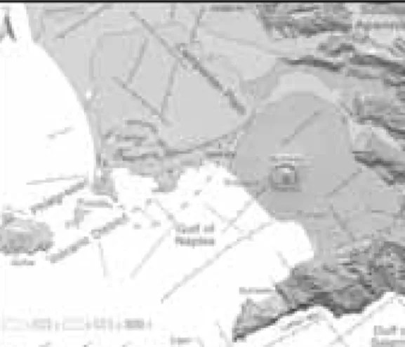
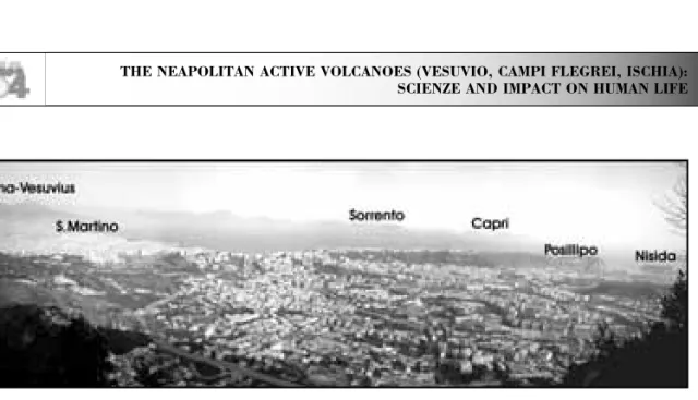
Naples is a very suitable site for a field trip devoted to the illustration of the problems of a megacity in an active volcanic area. In fact, together with its surrounding towns, it has been growing between the Campi Flegrei restless caldera and the Somma-Vesuvius, forming a megacity, which we would like to call «Parthenopean Megacity» (Fig. 1).
This megacity, lying on two active volcanic areas and being densely populated, is one of the best examples of high volcanic risk areas in the world.
Regional geologic setting
The Neapolitan area is located within the Campanian Plain, which is bordered by the Southern Apennines (Fig. 2). This mountain chain results from deforma-tion of the African continental margin and is com-posed of a variety of Mesozoic and Palaeogenic
palaeogeographic domains (D’Argenio et al., 1973). The crust is about 25-30 km thick and composed of a pile of tectonic thrusts made up of Triassic to Pliocene sedimentary rocks (Fig. 2) overlying a crystalline-metamorphic basement. From Miocene to Pliocene time, variable compressional tectonic phases have deformed both the sedimentary rocks and their basement terrain. Since Quaternary times, mostly extensional tectonic phases have generated the present setting of the Campanian area.
The Campanian Plain, in which lie the active vol-canoes, is composed of 2-3,000 m thick sequences of Plio-Quaternary continental, deltaic, and marine sediments, intercalated with volcanic deposits. It is underlain by a graben formed during activation of NW-SE and NE-SW trending normal faults which, at least during Quaternary times (Brancaccio et al., 1991), have downthrown the western Apennines. The regional stress regime, which has determined the formation of the plain, has also favoured genera-tion and rise of the magmas that have fed the recent and active volcanism. Geophysical data and deep wells have shown the presence of volcanic rocks beneath the sediments filling the plain. These rocks have calc-alkaline composition, while those exposed and overlying the sediments are alkaline. The latter belong to the Somma-Vesuvius composite volcano
Figure 1 - Intense urbanization of the Neapolitan area, from satellite imagery.
Figure 2 - Geological sketch map of the Neapolitan area. 1) Quaternary and active terrigenous sediments; 2) Somma-Vesuvius volcanics; 3) Phlegraean District vol-canics; 4) Pliocene and Miocene terrigenous sediments; 5) Mesozoic carbonate units; 6) faults; 7) overthrusts; 8) caldera margins.
V
olume n° 2 - fr
om B16 to B33
and the Phlegraean Volcanic District, which includes the Campi Flegrei, Ischia and Procida volcanoes. The active volcanoes are Campi Flegrei, Somma-Vesuvius and Ischia; at the island of Procida the last eruption occurred about 18 ka bp.
The Neapolitan area is mostly made up of volcanic rocks and subordinately of shallow-sea, alluvial, coastal and palustrine sediments (Fig. 2). The oldest dated rocks are exposed at Ischia and yield an age of 150 ka. Historical eruptions have occurred at Ischia (from VII century BC to 1302 AD), Campi Flegrei (1538 AD), and Vesuvius (from 79 to 1944 AD).
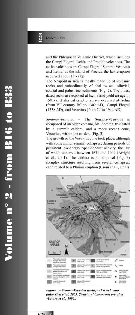
Somma-Vesuvius. – The Somma-Vesuvius is
composed of an older volcano, Mt. Somma, truncated by a summit caldera, and a more recent cone, Vesuvius, within the caldera (Fig. 3).
The growth of the Vesuvius cone took place, although with some minor summit collapses, during periods of persistent low-energy open-conduit activity, the last of which occurred between 1631 and 1944 (Arrighi et al., 2001). The caldera is an elliptical (Fig. 3) complex structure resulting from several collapses, each related to a Plinian eruption (Cioni et al., 1999).
The northern portion of the caldera margin is a 300 m high scarp, while the southern portion has been filled by lava flows, which covered the southern slopes of the Mt. Somma as far as the seacoast.
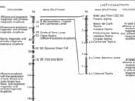
Volcanism in the Somma-Vesuvius area has been active since at least 400 ka bp as testified by vol-canic rocks drilled at 1,350 m depth (Brocchini et al., 2001). The Somma volcano formed after the Campanian Ignimbrite eruption of Campi Flegrei (39 ka; De Vivo et al., 2001) (Fig. 4) and its activity was mostly effusive and subordinately explosive, with low energy events (Cioni et al.,1999). The history of the volcano has been characterised either by long qui-escence periods, interrupted by Plinian or sub-Plinian eruptions, or by periods of persistent volcanic activ-ity (Fig. 4), with lava effusions and Strombolian to phreato-magmatic eruptions, related to the alternation of closed and open conduit conditions, respectively (Civetta and Santacroce, 1992).
The earliest known Plinian eruption (Pomici di Base; 18.3 ka; Cioni et al., 1999 and references therein) determined the beginning of both the collapse of the Mt. Somma volcano and the formation of the caldera. The Pomici di Base eruption was followed by erup-tion of lavas that flowed along the eastern slopes
Figure 3 - Somma-Vesuvius geological sketch map (after Orsi et al, 2003. Structural lineaments are after Ventura et al., 1999).
Figure 4 - Chronogram of volcanic and deformational history of Somma-Vesuvius (after Orsi et al., 2003).
5 -B28
V
olume n° 2 - fr
om B16 to B33
of the volcano, and a quiescent period interrupted 15 ka bp by the sub-Plinian eruption of the Pomici Verdoline (Cioni et al., 2003 and references therein). The subsequent long period of quiescence, during which only two low-energy eruptions took place, lasted until 8 ka bp, when it was broken by the Plinian Mercato eruption (Cioni et al., 1999 and references therein). During the following period of quiescence, interrupted only by two low-energy eruptions, a thick paleosol formed. This paleosol contains many traces of human occupation until the Early Bronze age, and is covered by the deposits of the Plinian Avellino eruption (Cioni et al., 1999 and references therein). This eruption was followed by at least 8 Strombolian to sub-Plinian eruptions, over a relatively short time, and by no less than 7 centuries of quiescence, broken by the Plinian AD 79 eruption (Cioni et al., 1999 and references therein). After this eruption, the volcano generated only two more sub-Plinian events in AD 472 (Rosi and Santacroce, 1983) and 1631 (Rolandi et al., 1993b; Rosi et al., 1993), and low-energy open-conduit activity between the 1st and 3rd, 5th and 8th, 10th and 11th centuries, and 1631 and 1944 (Arrighi et al., 2001). Since the last eruption of 1944, Vesuvius is quiescent, as it has not shown signs of unrest and only moderate seismicity and fumaroles testify its activity.
All Plinian eruptions are characterised by a vent opening, a sustained column and pyroclastic flow and/or surge phases, and are
accompanied by volcano-tectonic collapses. Sustained columns, which reach maxi-mum heights of about 30 km, generate widespread fallout deposits (1.5-4.4 km3, DRE)
(Fig. 5).
Pyroclastic currents (0.25 and 1 km3, DRE) are
distrib-uted along the volcano slopes and within the surrounding plains, reaching maximum distances of over 20 km from the vent. In proximal areas, thick breccia deposits are related to caldera collapse. The quiescence periods pre-ceeding the Plinian eruptions last from several centuries to millennia (Fig. 4)
Among the sub-Plinian eruptions of Vesuvius, only the AD 472 and the 1631 events are studied in detail
(Rosi and Santacroce, 1983; Rolandi et al., 1993; Rosi et al., 1993). They are characterised by the alter-nation of sustained columns and pyroclastic flow and/ or surge generation. Sustained columns are less than 20 km high and pyroclastic currents travel distances not in excess of 10 km.
Fallout deposits of both Plinian and sub-Plinian eruptions are dispersed to the east of the volcano Vesuvius is located at the intersection of NW-SE and NE-SW oriented fault systems. The results of seismic investigations, constrained by one deep drilling (Zollo et al., 2002) show that the shallow structure of Vesuvius comprises 1.5-2 km of interbedded lavas and volcaniclastic, marine, and fluvial sedimentary rocks of Pleistocene age. A high velocity body, likely to be a sub-volcanic structure, is under the summit caldera. The top of the Mesozoic limestone basement is at 2.5-3 km of depth. The occurrence of a high-P wave velocity zone beneath the volcano, which extends from about 0.5 to 2-3 km of depth, as well as of local volcano-tectonic seismicity shallower than 6-7 km of depth (Bianco et al., 1998), indicate that it is extremely unlikely that shallow magmatic reservoirs of significant size (>1 km in diameter) occur in the 0-7 km range of depth. Furthermore, the results of a seismic tomography study (Auger et al., 2001) identify a horizontal low-velocity layer with its flat top at about 8 km beneath the volcano. This is interpreted as the top of the present magma
Figure 5 - Distribution of Plinian and sub-Plinian depos-its of Somma-Vesuvius eruptions.
V
olume n° 2 - fr
om B16 to B33
reservoir. This depth coincides with the upper portion of a zone of clinopyroxene crystallization, indicated by fluid inclusion data (Belkin et al., 1985; Marianelli et al., 1995; 1999). The Moho discontinuity in the Vesuvius area is at a depth of 29-30 km (Gasparini
et al., 2001).
In its history Somma-Vesuvius has erupted about 50 km3 of magma of varying composition. According to
the different degrees of silica under-saturation of the erupted magmas, it is possible to distinguish three periods of activity (Santacroce, 1983). The oldest, from ca. 39 to 11.5 ka bp, is characterised by emission of slightly u n d e r - s a t u r a t e d lavas, of variable composition from K-basalt to K-trachyte. The second period, from 8 ka bp to AD 79, is characterised by the emission of products varying in composition from tephrite to phonolite. The products of the last period, from AD 79 to AD 1944, range from leucititic tephrite to leucititic phonolite.
All these products show a range of Sr-Nd-Pb isotopic c o m p o s i t i o n s (D’Antonio et al., 2004 and references therein): 87Sr/86Sr
ratio ranges between 0.7066 and 0.7080;
143Nd/144Nd ratio
ranges from 0.5126 to .5124; Pb isotope ratio show smaller ranges (e.g. of values for
δ
18O (7.3-11.4‰) is reported (Ayuso et al., 1998 and references therein), whereas3He/4He ratios are clustered around 2.4 R/R
a (Graham
et al., 1993). Sr and Nd isotopes of the Plinian and Strombolian products show a variation through time, with increasing or decreasing 87Sr/86Sr ratio (and the
Figure 6 - a) Structural map of the Campi Flegrei caldera; b) SW-NE cross section (location is shown in the insert); c) simple-shearing block resurgence model for the caldera complex; d) vertical ground movements at Serapis Roman market in Pozzuoli.
7 -B28
V
olume n° 2 - fr
om B16 to B33
opposite for Nd isotopes) from the first to the last erupted magma. Strong isotopic disequilibria occur among minerals and between minerals and glass. The Sr- and Nd-isotopes have been used to investigate the processes in the magma reservoirs. The isotope and geochemical data for Plinian eruption products evidence that the magma chamber(s) feeding Plinian eruptions (3-5 km depth; Barberi et al., 1981) are refilled by isotopically distinct, mafic, high-T (>1150 °C) magma batches rising from depths of 10-20 km (Cioni et al., 1999 and references therein), where mantle-derived magmas stagnate, differentiate and probably are contaminated by continental crust.
The deep magma batches, through crystallization and mixing with the shallow portions of the feeding systems, generate isotopically and geochemically layered reservoirs. On the contrary, during open conduit conditions the deep, volatile-rich magma batches rise to less than 2 km of depth and mix with the crystal-rich, volatile-poor resident magma, triggering eruptions (Marianelli et al., 1999 and references therein).
Campi Flegrei caldera - The Campi Flegrei caldera,
the main feature of the Phlegraean Volcanic District,
includes a continental and a submerged part. It is a resurgent nested structure (Fig. 6) formed during two major caldera collapses related to the eruptions of the Campanian Ignimbrite (39 ka; Fedele et al., 2003 and references therein) and the Neapolitan Yellow Tuff (15 ka; Deino et al., 2004 and references therein), respectively (Orsi et al., 1996).
The geometry and dynamics of both large calderas, as well as of smaller volcano-tectonic collapses, were deeply influenced by both local and regional stress regimes. Each large collapse affected the structural conditions of the system, and constrained the foci of later volcanism. The age of the beginning of volcan-ism in the area is not known. The oldest dated vol-canic unit yielded an age of 60 ka (Pappalardo et al., 1999) and is related to a volcanism extending beyond the caldera (Fig. 6a)
The Campanian Ignimbrite eruption and caldera collapse was the earliest event to profoundly influ-ence the present geological setting of the area. The Neapolitan Yellow Tuff eruption and caldera collapse was the last dramatic event in the history of the cal-dera.
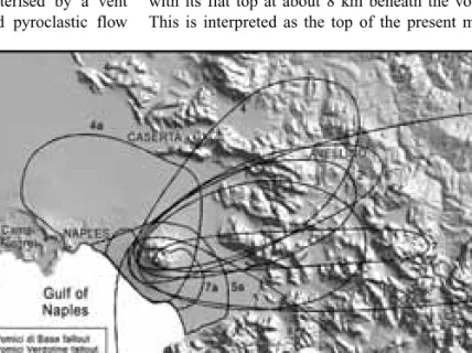
After the Neapolitan Yellow Tuff eruption, both volcanism and deformation have been very intense within the caldera (Fig. 6, 7) (Orsi et al., 1999a and references therein). There have been about 70 erup-tions, grouped in three epochs of activity (15.0-9.5, 8.6-8.2 and 4.8-3.8 ka), during which eruptions have followed one another at mean time intervals of a few tens of years. The last event was in 1538, after about 3.0 ka of quiescence (Fig. 7), and formed the Mt. Nuovo cone (Di Vito et al., 1987). 64 of these eruptions were phreatomagmatic to magmatic explosive events. Contemporaneous magmatic and phreatomagmatic fragmentation dynamics has been widely recognised and has been demonstrated for the Agnano-Monte Spina eruption (Dellino et al., 2004a and references therein). Only the Pomici Principali (10.3 ka; Di Vito et al., 1999 and references therein) and the Agnano-Monte Spina, occurred during the I and III epochs of activity respectively were of high-magnitude, Plinian eruptions. On the basis of the extent of the area covered by the deposits, considered as indicative of the magnitude, the other explosive events have been subdivided by Orsi et al. (2004) in low- and medium-magnitude eruptions. Fallout deposits of the I epoch covered the north-eastern sec-tor of the caldera and the Camaldoli hill, 15 km from the caldera centre (Fig. 8a). Only beds of the Pomici Principali Tephra are 20 cm thick along the western
Figure 7 - Chronogram of volcanic and deformational history of the Campi Flegrei caldera (after Orsi et al., 2003).
V
olume n° 2 - fr
om B16 to B33
margin of the Apennines, at about 50 km from the vent. Pyroclastic currents travelled within the caldera floor and reached the Campanian plain. The eruptions of the II epoch were all low-magnitude events. Fallout deposits covered only the caldera and its immediate surroundings, while most of the pyroclastic currents deposited their load within the caldera lowland (Fig. 8b). The fallout deposits of the III epoch and of the Mt. Nuovo eruption covered the caldera floor and its surroundings (Fig. 8c). Only beds of the Agnano-Monte Spina Tephra covered a large area up to the
Apennines. Pyroclastic currents travelled across the caldera floor and subordinately over the northern slopes of the Camaldoli hill (de Vita et al., 1999). The caldera has been affected by structural resur-gence through a simple-shearing mechanism (Orsi et al., 1991) that broke its floor in blocks and caused a maximum net uplift of about 90 m at the La Starza marine terrace (Fig. 6) (Orsi et al., 1996). The dis-tribution of the vents active through time (Fig. 6a) is a good tracer of the structural conditions of the caldera. In fact during both the I and II epochs vents were mostly located along the marginal faults of the Neapolitan Yellow Tuff caldera. Whereas the vents of the III epoch were along the normal faults intersect-ing the north-eastern portion of the Neapolitan Yellow Tuff caldera floor, in response to the simple-shearing mechanism, established not later than 5 ka bp (Orsi
Figure 8 - Distribution of the pyroclastic deposits of the past 15 ka at the Campi Flegrei caldera. a, b and c: 10-cm isopachs of fallout deposits of the I, II and III epoch, respectively; a’, b’ and c’: areal distribution of pyroclastic-current deposits of the I, II and III epoch, respectively.
9 -B28
V
olume n° 2 - fr
om B16 to B33
et al., 1999a).
This mechanism generated a compressive stress regime within the south-western portion of the caldera floor, the Pozzuoli bay, and a tensile stress regime within the north-eastern portion, the area between the Agnano and San Vito plains (Fig. 6). Only Averno 1 and 2, and Mt. Nuovo eruptions occurred in the sector where the two fault systems delimiting the resurgent block north-westward, intersect.
During the past 2.0 ka, the floor of the caldera has been affected by ground movement, documented at the Serapis Roman market in Pozzuoli (Fig. 6d). Since late 1960s, unrest episodes have been documented by the monitoring system in 1969-72, 1982-84, 1989, 1994 and 2000, and have generated uplifts of 170,
180, 7, 1 and 4 cm, respectively. Geometry of these short-term deformation events are very similar to that of the long-term deformation. This element, together with the earthquake focal mechanisms, suggest that also the unrest episodes occur through a simple-shearing mechanism. Therefore they are likely to be transient events during the long-term deformation and reflect the stress regime within the caldera, which has not changed at least over the past 5 ka (Orsi et al., 1999a).
The magmas erupted at Campi Flegrei range in composition from trachybasalt to phono-trachyte, with a predominance of trachyte (D’Antonio et al., 1999 and Pappalardo et al., 1999, and references therein). The less differentiated magmas (trachybasalt and latite) erupted between 10 and 8 ka along NE-SW
regional tectonic structures (Orsi et al., 1996). Seismic data show that beneath the Campi Flegrei caldera, the top of the Mesozoic limestone basement occurs at about 4 km depth (Zollo et al., 2003), above which no evidence of magma reservoirs of significant size has been found. Melt inclusion data indicate zones of clinopyroxene and olivine crystallization between 10 and 20 km depth, suggesting the presence of deep magma reservoirs (Cecchetti et al., 2001), at the same depth of those estimated for Vesuvius. The depth of the Moho below the Phlegraean Volcanic District is of about 25 km (Ferrucci et al., 1989). The Campi Flegrei rocks exhibit a wide range of 87Sr/ 86Sr (0.7068-07086), but limited ranges of 143Nd/144Nd
(0.51240-0.51266) and Pb-isotope ratios (e.g. 206Pb/ 204Pb: 18.85-19.25; Pappalardo et al., 2002a, b and
references therein). Wide ranges of δ18O (Turi and
Taylor, 1976) and δ 11B (Tonarini et al., 2004) have
also been measured.
Variations of Sr, Nd and Pb isotope ratios of magmas erupted since 60 ka illustrate the history of the Campi Flegrei magmatic system. 87Sr/86Sr increases from 60
to 44 ka, is constant from 44 to 17 ka, increases again at 15 ka, prior to the Neapolitan Yellow Tuff eruption, and then exhibits a wide range, between 0.7073 (value characteristic of Campanian Ignimbrite) and 0.7086. The increase of 87Sr/86Sr is associated with
a decrease in the Nd isotope ratio. According to the isotopes-time correlation, Pappalardo et al. (2002b) have identified four groups of magmas: 1) trachytic magmas erupted before Campanian Ignimbrite (87Sr/ 86Sr ca. 07068); 2) Campanian Ignimbrite trachytic
magmas (87Sr/86Sr ca. 0.7073); 3) Neapolitan Yellow
Tuff latitic to trachytic magmas (87Sr/86Sr ca. 0.70755);
4) shoshonitic magmas erupted for the first time at ca. 10 ka (87Sr/86Sr ca. 0.708) along portions of regional
faults. The shoshonitic magmas contain xenoliths and xenocrysts of probable crustal origin, enriched in radiogenic Sr (87Sr/86Sr up to 0.711; Pappalardo
et al., 2002b). Mixing/mingling among the four components can explain all the isotopic variations of the post-Neapolitan Yellow Tuff products.
The structure of the magmatic system is, therefore, characterised by a deep reservoir extending between 20 and 10 km depth, where mantle derived magma stagnate and eventually are contaminated by con-tinental crust (Pappalardo et al., 2002b). From the deep reservoir, magmas rise to shallow depth, where they either form large chambers, or reach the surface through regional faults along which they mix with residual melts.
Figure 9 - Geological sketch map of Ischia (after Orsi et al., 2003).
V
olume n° 2 - fr
om B16 to B33
Ischia - The island of Ischia, the emerged top of a large
volcanic complex rising more than 1,500 m above sea floor, is an active volcanic field that covers an area of about 46 km2 and is dominated by Mt. Epomeo (787
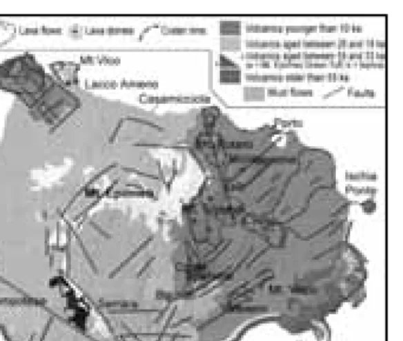
m a.s.l.). Ischia is composed of volcanic rocks, land-slide deposits, and subordinate terrigenous sediments (Fig. 9). The volcanic rocks range in composition from trachybasalt to phonolite; the most abundant are trachyte and alkali-trachyte. Volcanism began more than 150 ka bp (Vezzoli, 1988) and continued until the last eruption of 1302 AD (Fig. 10).
The oldest rocks are exposed in the south-eastern part of the island and belong to a partially exposed volcan-ic complex. The products of the volcanism between 150 and 74 ka bp, are small trachytic and phonolitic domes at the periphery of the island. A poorly defined period of pyroclastic activity followed, predating the large Mt. Epomeo Green Tuff caldera-forming erup-tion (55 ka). Lacking a detailed stratigraphic and compositional study on the volcanics aged between 74 and 55 ka, volcanism in the past 55 ka has been tentatively subdivided into three periods of activity (Civetta et al., 1991).
The Mt. Epomeo Green Tuff consists mostly of tra-chytic ignimbrites that partially filled a depression invaded by the sea in what is now the central part of the island. The caldera collapse was followed by the Mt. Epomeo block resurgence, which occurred through a simple-shearing mechanism (Fig. 6c) and determined a net uplift of about 900 m (Orsi et al., 1991). Volcanism continued with a series of hydromagmatic and magmatic explosive eruptions of trachytic magmas up to 33 ka. Most of the vents
were located along the present south-western and north-western periphery of the island.
After a 5 ka long period of quiescence, volcanism resumed at about 28 ka with the eruption of trachyba-saltic magma along the south-eastern coast, and then continued sporadically until 18 ka. Hydromagmatic and magmatic explosive eruptions along the southern coast mostly erupted alkali-trachytic magmas, while effusive eruptions formed trachytic lava flows. The most recent period of activity began at about 10 ka. Volcanism has been mainly concentrated in the past 2.9 ka, with almost all the vents in the eastern part of the island (Sansivero, 1999). Only a few were outside this area, along regional faults. They gener-ated a lava field, in the north-western corner of the island, and a pyroclastic sequence in the south-west-ern part. At least 35 effusive and explosive eruptions took place. Effusive eruptions emplaced lava domes and high-aspect ratio lava flows. Explosive eruptions, both magmatic and phreatomagmatic, generated tuff cones, tuff rings and variably dispersed pyroclastic-fall and -flow deposits. Emplacement of landslide and mudflow deposits prior and after these eruptions testi-fies ground deformation, and are likely to be related to resurgence.
Geological and petrological data, as well as the results of modelling of magnetic data (Orsi et al., 1999b), suggest that the magmatic system of Ischia is presently composed of a deep and poorly-evolved magma reservoir, interconnected with shallower, smaller and more-evolved magma batches, which have fed the recent activity.
The magmas erupted at Ischia have a wide range of isotopic values: 87Sr/86Sr ratio varies between 0.7058
and 07073, while 143Nd/144Nd ratio varies between
0.51246 and 0.51261 (Civetta et al. 1991b); 206Pb/ 204Pb ratio varies between 18.88 and 19.05 (Arienzo et
al., 2004); δO18 varies between 6.14 and 6.99. The Sr
isotopic ratios are generally less radiogenic than those of Vesuvius and Campi Flegrei, while the Nd, Pb and B isotopic ratios are similar. Geochemical and iso-topical variations through time (Civetta et al., 1991) have evidenced that the magmatic system between 55 and 33 ka acted as a closed system. Before the 28-18 ka period of activity, it was refilled by a deeper less-evolved magma, which progressively mixed with the more-evolved resident magma. The last period of activity was preceded by arrival of new magma. Complex mingling/mixing processes operated till the last eruption, as testified by isotopic and mineralogi-cal disequilibria.
Figure 10 - Chronogram of volcanic and deformational history of Ischia.
11 -B28
V
olume n° 2 - fr
om B16 to B33
Origin of the Campanian magmas - In agreement
with geophysical and geological data on the geodynamics of the Tyrrhenian Sea and the structural setting of Neapolitan volcanoes, the isotopic data (Sr, Nd, Pb, B) (Tonarini et al., 2004; Arienzo et al., 2004; Civetta et al., 2004) suggests the involvement of three components in the genesis and evolution of the feeding magmas: 1) the T-MORB asthenospheric mantle, mostly represented by Tyrrhenian seafloor basalts and, in part, by Procida K-basalts; 2) fluids derived from sediments of the Ionian NW-dipping subduction zone, which progressively modify the mantle wedge in relation to Ischia-Procida and Vesuvius-Campi Flegrei; 3) fluids deriving from the continental crust which contaminate the mantle derived magmas. This last process is operative mostly on the post-39 ka Vesuvius and Campi Flegrei magmas, at a depth between 10 and 20 km, where mineralogical and geophysical data indicate the occurrence of discrete magma reservoirs. From these depths, batches of isotopically distinct magmas rise to shallow reservoirs, where they mix with the resident magma, differentiate and, in cases, can trigger an eruption.
Field itinerary
DAY 1
Stop 1:
The 1944 eruption of Vesuvius and the present Crater
Significance. - The 1944 last eruption of Vesuvius.
Evolution of the crater after the 1906 eruption. Physical and socio-economical features.
The 1944 eruption. - The 1944 eruption is the last
eruption of the Vesuvius. Since then, the volcano has been quiescent, only fumaroles and moderate seismicity testify its activity. The 1944 eruption clo-sed a cycle of persistent activity, begun in 1914 and characterised by mainly effusive central eruptions. 50-100 millions of m3 of lavas and pyroclasts had
almost completely filled the 1906 eruption crater (720 m wide and 600 m deep).
Imbò (1949) reported a detailed description of the eruption, which is here summarised.
On March 13, the spatter cone, emerging from the crater, began to collapse and seismicity increased. A new cone formed between March 13 and 16 and col-lapsed on March 17.
The eruption begun on the afternoon of March 18th
with Strombolian activity. A lava flow overflowed out of the northern portion of the crater rim at 4.30 pm, and reached the Valle dell’Inferno at 10.30 pm (Fig. 11).
Other lavas overflowed the southern portion of the rim, almost simultaneously, and the western portion at 11.00 pm, reaching the Fosso della Vetrana at 11.00 am of March 19. From the afternoon of March 20 and for the following night, new lava flows overflowed the northern portion of the crater rim. On March 21st, the southern lava flow stopped at about 300 m
a.s.l., while the northern flow reached the towns of S. Sebastiano and Massa di Somma between 1.00 and 2.00 am. The 10,000 inhabitants were evacuated and transferred to Portici. Around 5.00 pm a new phase of the eruption which generated 8 spectacular lava fountains, began and lasted till 00.48 pm of the next day. The last fountain, lasted about 5 hours, reached a height of about 1,000 m. Scoriae and ash fallout beds were laid down southeast of the volcano, between the towns of Angri and Pagani. A large amount of incan-descent scoriae, due to the ground movement related to intense seismic tremor, generated hot avalanches which reached the foot of the cone.
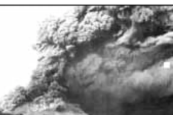
At 00.48 pm of March 22nd there was a transition from
the lava fountain phase to a buoyant column phase (Fig. 12). The convective portion of this column, 5-6 km high, was dispersed towards south-east. Partial collapses generated pyroclastic currents which moved along the slopes of the cone. This eruption phase, during which the crater enlarged progressively, was characterised by intense seismic tremor. On March
Figure 11 - Distribution of the 1944 Vesuvius eruption deposits.
V
olume n° 2 - fr
om B16 to B33
23 a new and last phase began. It was dominated by phreatomagmatic explosions with energy decreasing through time. Also seismicity changed from tremor to discrete shocks. The ash-rich columns were directed towards the south-south-west, and small pyroclastic currents flowed on the slopes of the cone (Fig. 13). The eruption ended on March 29.
The 1944 products range in composition from pho-nolitic tephrite to tephrite. The lower portion of the pyroclastic sequence includes both brownish vesicular and dark dense lapilli juvenile clasts. The two types of clasts, petrographically and chemically similar, differ for vesicularity, matrix colour (yellow-ish to brown(yellow-ish) and crystallinity. The upper portion of the sequence includes only denser juvenile clasts, rich in clinopyroxene.
Phenocrysts content increases and vesicularity decreases up-section. Clinopyroxene is ubiquitous phenocryst phase and occurs in two varieties, a
col-ourless diopside and a greenish salite. Leucite, plagi-oclase, biotite and olivine occur as phenocrysts and in glassy groundmass during the whole sequence, in varying proportions. Leucite at the base and clinopy-roxene and olivine upward occur as loose megacrysts during the whole sequence.
K-phonotephritic magma was emitted during the effusive phase and the first lava fountain, whereas strongly porphyritic K-tephritic magma was extruded during the most intense fountain. Melt inclusions compositions (major and volatile elements) highlight that the erupted magmas underwent differentiation at different pressures. The K-tephritic volatile-rich magma (up to 3wt.% H2O, 3.000 ppm CO2 and 0.55wt. % Cl) evolved to a K-phonotephritic melt through crystallization of diopside and forsteritic olivine at total fluid pressure >300 MPa. This magma fed a very shallow reservoir. The low pressure dif-ferentiation of the volatile-poor K-phonotephritic magmas (H2O less than 1wt.%) involved mixing, open-system degassing, and crystallization of leucite, salite, and plagioclase. The eruption was triggered by intrusion of a volatile-rich magma rising from a depth of 11-22 km into the shallow magma chamber. The lava effusion phase of the eruption partially empted the shallow reservoir, the top of which is within the caldera edifice. The newly arrived magma mixed with that resident in the shallow reservoir and forced the transition to the lava fountain phase.
The pyroclastic deposits contain lithics of skarn and other thermo-metamorphic rocks, grouped in four main lithotypes: metasomatised cumulites, Ca-skarn, Mg-skarn and cornubianites. These rocks, which could result from an interaction between magma and magma chamber sedimentary wall-rocks (limestones, dolomites, marls and siltites), are particular in this 1944 eruption. Their occurrence suggests that the magma chamber was a high aspect ratio structure, reaching the sedimentary basement of the volcano around 3-4 km of depth. The presence of periclase in the Mg-Skarn could suggest hypo-abyssal conditions with maximum pressures of 1,000 bars.
The most relevant effects of the eruption were: twenty-six people dead in the area affected by lapilli and ash fallout, due to a collapse of the roots; two vil-lages partially destroyed by lava flows; three years of missed crops in the downwind area.
The crater - A complete sequence of the 1914-1944
deposits of the last cycle of activity at Vesuvius is exposed along the north-eastern portion of the crater
Figure 12 - Buoyant column phase of the 1944 Vesuvius eruption.
Figure 13 - Partial column collapse with generation of pyroclastic currents during the 1944 Vesuvius eruption.
13 -B28
V
olume n° 2 - fr
om B16 to B33
slope (Fig. 14). The sequence is dominated by lavas, the most significant was extruded on 1929, with minor spatter and scoriae beds. It is horizontal, fills the 1906 eruption crater and unconformably covers the sequence of rocks exposed in the 1906 crater. Both sequences are topped by the deposits of the 1944 eruption in parallel unconformity.
A grey massive lava, the basal unit of the 1944 erup-tion sequence (Fig. 15), is a continuous layer grading into a densely-welded crudely-stratified spatter suc-cession emplaced during the lava fountaining phase. The largest part of this succession was emplaced dur-ing the VIII fountain (7.30 am -00.48 pm, March 22), when concomitance of rapid spatter accumulation and strong seismic tremor, caused hot avalanches. The spatter succession is covered in parallel unconformity by another succession of black and grey scoriaceous lapilli and bomb deposits with interlayered coarse ash
beds. Variation in deposit characteristics is related to the change in fragmentation dynamics at 00.48 pm, with the formation of a buoyant ashy column. The upper part of the 1944 sequence is composed of intercalated reddish and violaceous lapilli and bomb deposits, and coarse ash beds, and is topped by grey ash deposits rich in lithic fragments, mainly composed of fresh and hornfelsed lavas. It was deposited during the phreatomagmatic final phase of the eruption.
The Vesuvius fumaroles. - Fumarole activity is
widespread in the Vesuvius crater area. Fumaroles of the crater rim and of the inner crater slopes
discharge fluids rich in atmospheric gases with outlet temperatures ranging from 60 to 75°C. The fumarolic fluids of the crater bottom (vents FC1, FC2, and FC5) have, instead, typical hydrothermal compositions, with H2O as a major constituent, followed by CO2, H2, H2S, N2, CH4, and CO in order of decreasing concentrations, and undetectable SO2, HCl, and HF. These fumaroles, whose outlet temperatures have been close to the local water boiling point since 1988, are fed by a hydrothermal system located underneath the crater.
Fumarolic water is either meteoric water enriched in 18O through water-rock oxygen isotope exchange
in the hydrothermal environment or a mixture of
Figure 14 - View of the north-eastern portion of the Vesuvius crater.
Figure 15 - The 1944 Vesuvius eruption deposits along the northern crater wall.
Figure 16 - Geochemical model of the Vesuvius hydrothermal system.
V
olume n° 2 - fr
om B16 to B33
meteoric and arc-type magmatic water, as indicated by the δ18O
H2O values, suitably corrected for oxygen
isotope exchange between H2O and CO2, and the
δDH2O values. It is equally possible that both water-rock oxygen isotope exchange and addition of mag-matic water take place in the hydrothermal system of Vesuvius crater.
Fumarolic CO2 has a double origin: part of The CO2 is of deep provenance (magmatic), and part is from metamorphic reactions involving marine carbonates (although addition of a small fraction of magmatic CO2 cannot be ruled out), as suggested by both the
δ13C
CO2 values and gas equilibria. The decarbonation
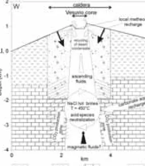
reactions result from a local thermal anomaly in the thick carbonate sequence, at >2.5 km underneath the volcano (Chiodini et. al., 2001) (Fig. 16).
Seen the large availability of salts in deep volcanic hydrothermal environments, mainly due to absorption of acid, magmatic gases in deeply circulating
ground-waters and the subsequent neutralization of these acidic aqueous solutions through water-rock interac-tion, it seems likely that NaCl liquids of unknown (probably high) salt content rather than pure water, circulate in the Vesuvius hydrothermal system. Accepting this hypothesis, gas equilibria was inves-tigated taking into account the solubility of relevant gas constituents in NaCl aqueous solutions of speci-fied concentrations. It turns out that C-H-O gas spe-cies equilibrate, probably in a saturated vapour phase, at very high temperatures: 360 to 370°C for vent FC1 and 430 to 445°C for vents FC2 and FC5. The minimum salinity of the liquid phase coexisting with
the vapour phase is close to 14.9 wt.% NaCl (1 m), whereas its maximum salinity is 49.2 to 52.5 wt.% NaCl (2m and 3m), corresponding to saturation with halite (Fig. 17).
As the salt contents of the aqueous solutions circulat-ing in this system cannot be constrained satisfactorily, total fluid pressures (which are closely approximated by PH2O + PCO2) in the zones of the hydrothermal system where gases equilibrate, are also poorly constrained. They are 260 to 480 bar for vents FC2 and FC5 and 130 to 220 bar for vent FC1. Based on a simple hydrostatic model (Fig. 18), the hydrother-mal reservoirs connected with these fumaroles are at depths of 2.6-4.8 km and 1.3-2.2 km, respectively. Consequently, the deepest hydrothermal reservoir appears to be within the carbonate sequence, which is at depths >2.5 km underneath the volcano, whereas the shallowest reservoir is in the overlying volcanic rocks.
Monitoring the thermodynamic conditions of this hydrothermal system trough the study of the fuma-roles chemical composition is of primary relevance in the surveillance of Vesuvius.
A detailed CO2 flux campaign on the Vesuvius cone, indicates that the degassing process of hydrothermal gases affects most of the slopes and bottom of the crater, and few spots on the slopes of the cone. A total CO2 output is estimated at 100±20 td-1.
Figure. 17 - Gas equilibria within the H2O-H2-CO2
-CO-CH4 gas system (after Chiodini and Marini, 1998).
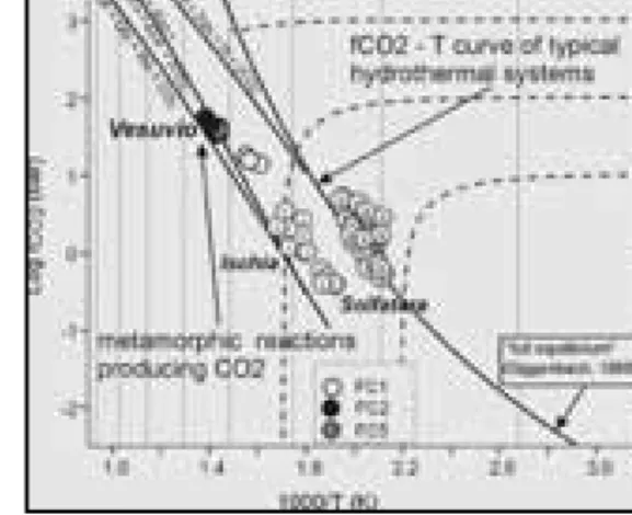
Figure 18 - Carbon dioxide fugacities versus 1000/T (K) diagram. The points of Vesuvius are representative of a very high temperature hydrothermal system (400-500°C). The carbon dioxide fugacity of the Vesuvius hydrothermal system might be controlled by thermo-metamorphic reactions.
15 -B28
V
olume n° 2 - fr
om B16 to B33
Discussion points. - Transition from lava
fountain-ing conditions to buoyant column reflects different fragmentation conditions in the conduit or modifica-tions of the vent geometry? Non vesiculated juvenile material characterises the lithic dominated Vulcanian deposits suggesting that ground-water entered the conduit, and fragmentation was triggered by magma-water interaction. Hydrothermalised lavas and dykes are subordinate in the deposit suggesting a minor role of hydrothermal fluids in triggering Vulcanian explosions.
Stop 1.2:
The Osservatorio Vesuviano
Significance. The Osservatorio Vesuviano historical
building, presently an information centre on volcanic hazards and risk.
The Osservatorio Vesuviano. - The Osservatorio
Vesuviano, the oldest volcano observatory in the world, was founded in 1841 by king Ferdinand II of Bourbon. It was inaugurated during the 7th Congress
of the Italian Scientists, held in Naples in 1845. The historical building of the Osservatorio Vesuviano, the elegant work of the architect Gaetano Fazzini, is on the Colle del Salvatore at an elevation of 609 m a.s.l., between Ercolano and Torre del Greco. The position chosen was particularly favourable since the site, hosting already a small church and a hermitage dating back to 1600, had never been damaged by the very frequent eruptions, occurred after the large 1631 event. The first director was Macedonio Melloni, one of the most prominent experimental physicists. The construction was completed in 1848; only a few months later, for political reasons, Macedonio Melloni was dismissed as director. His successor was the physicist Luigi Palmieri, at the time professor of philosophy at the University of Naples, who provided the Osservatorio with a meteorological tower. Luigi Palmieri built the first electromagnetic seismograph, with which he wanted to “make the smallest motions of the ground clear, recording them on the paper or indicating their nature, strength and duration”. He first detected harmonic tremor caused by magma oscillation and degassing in the conduit and conclud-ed that such a phenomenon could be usconclud-ed to forecast an eruption. The following directors were Raffaele Vittorio Matteucci and Giuseppe Mercalli. The latter, inventor of the homonymous scale of seismic inten-sity, drew the first modern classification of volcanic eruptions. Ciro Chistoni and Alessandro Malladra followed Mercalli as directors . In 1937 Giuseppe
Imbò was appointed as director. He strengthened the existing instruments on the volcano reaffirming the old objectives of Melloni and Palmieri on forecasting eruptions. He made instruments for seismological, electrical and radioactive observations, hoping to forecast the final eruption of the cycle begun in 1913. Imbò with the aid of a seismograph and observations on the Vesuvius activity, managed to forecast the 1944 eruption and to inform the authorities. He was director until 1970, the year of the first ascending phase of the recent Phlegraean bradyseismic events. In the second half of the 1990s the Osservatorio Vesuviano has gone through the most significant change of its long history. It was transformed into a volcano observatory capable of carrying out research and technical activities aimed at performing long- and short-term forecasting of volcanic eruptions, volcanic hazard assessment and zoning of the territory exposed to the hazards. In such an atmosphere, the historical building of the Osservatorio Vesuviano was transformed in a volcanology museum, with the aim of disseminating information on volcanic hazards and risk. At present the Osservatorio Vesuviano is a section of the Istituto Nazionale di Geofisica e Vulcanologia.
Discussion points. – Volcanic eruption forecasting.
Information and education as tools for risk mitiga-tion.
Stop 1.3:
The AD 79 eruption at Herculaneum excavations
Significance. – The most famous Plinian eruption and
its effects on land and urban settlements.
The AD 79 “Pompeii” eruption. - On August 24 of
AD 79, Vesuvius awakened, and destroyed the towns of Herculaneum, Oplontis, Pompeii and Stabiae. The eruption has been studied by many authors (Lirer et al., 1973; Sigurdsson et al., 1985; Barberi et al., 1989; Cioni et al., 1999; Gurioli et al., 2002) and three major phases have been distinguished: (1) opening phreatomagmatic; (2) main Plinian; (3) caldera-forming with phreatomagmatic surges and flow emplacement. Significant variations of the characteristics of the pyroclastic deposits have allowed the definition of Eruption Units, deposits emplaced by pulses within a phase, with well defined eruptive mechanism. The AD 79 eruption sequence includes 8 Eruption Units, each with distinct areal distribution and lateral variations (Fig. 19, 20).
V
olume n° 2 - fr
om B16 to B33
An accretionary lapilli-rich ash layer (EU1), the only product of the opening phreatomagmatic phase, is covered by the pumice-fall deposit of the Plinian phase. This latter phase was dominated by an eruption column which reached a maximum altitude of 30 km. The Plinian deposit is composed of white phonolitic pumice (EU2F), locally capped by a thin, whitish
ash-flow deposit (EU2/3PF), which passes upwards, with
a sharp colour change, to grey, mafic phonolitic pum-ice (EU3F). The upper part of the deposit contains
intercalated ash-flow beds (EU3PF) and is closed by
pumice and ash flow deposits in proximal exposures. During this phase, which tapped more than 3 km3 of
magma, thick fallout deposits accumulated on a large area to the southeast, and pyroclastic-current deposits
buried Herculaneum to the south. The caldera forming phase began with the most powerful and widespread pyroclastic current (EU4). The strong earthquake and the dark cloud witnessed by Pliny the Younger at Cape Misenum on the morning of August 25th is likely to correspond to this pyroclastic current. The currents of this phase destroyed human settlements along the western and northern slopes of the volcano and devastated the Pompei-Stabia area. The caldera-forming phase continued with the emplacement of the pyroclastic-current deposits of EU5, distributed in proximal areas and confined in valleys of the vol-canic edifice. EU5 is covered by very coarse, lithic breccia flow deposits of EU6, extensively exposed along the eastern slopes of Mt. Somma.
Areal distribution as well as lithic types and content
Figure 19 - Generalised sequence of the AD 79 Vesuvius eruption deposits.
17 -B28
V
olume n° 2 - fr
om B16 to B33
of the latter deposits, suggest that they were erupted during the paroxistic events of the caldera-forming phase. The protracted withdrawal of the magma chamber, favoured by magma-water interaction, led to tapping of the more mafic liquid that characterises the juvenile fraction of the widespread EU7. During the waning stage of the eruption, wet, phreatomag-matic, ashy pyroclastic currents (EU8) were gener-ated, showing a sharp compositional reversal towards the more salic compositions of the initial phase of the eruption.
The Plinian deposits (fall and minor flows) range from early phonolitic white pumice to late tephritic-phonolitic grey pumice; the upper phreatomagmatic flow units exhibit larger variations with both grey and white pumice clasts and more abundant mafic crystals in the grey pumice. White pumice results from the withdrawal of phonolitic magma from the top of the chamber. Temperature was evaluated at about 850-900° on the basis of homogenisation temperature of glass inclusions in sanidine and leucite. The grey pumice results from the mixing of three isotopically distinct components: phonolitic white melt, mafic cumulates and a crystal-poor grey magma. The grey magma had high temperature (around 1050° C), very low viscosity and density slightly higher than that of the white magma. These features are consistent
with the establishment of a physical discontinuity separating the white from the grey body. The lower portion of the Pompeii chamber was therefore occupied by a homogeneous, phonolitic-tephritic, grey magma which was never erupted without being largely mixed. The grey-white mixing was mainly sin-eruptive, as suggested by variations in magma discharge rate closely linked to the extent of the mixing.
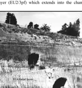
The Herculaneum excavations
Herculaneum Beach. - The grey wall (23 m thick)
including at least six units, is the best exposure of the AD 79 pyroclastic-current deposits that buried Herculaneum (Fig. 21).
These deposits lie on the old coastline. Along the waterfront a series of arches form the base of the Sacred Area. Each arch forms a chamber. On the southern part of the waterfront are the Suburban Thermae. The beach and the shoreline consisted of yellow tuff of the Avellino eruption, covered by black sand. The tuff formed a wave-cut platform whose surface was worked to provide a slip-way for large boats.
The first deposit of the eruption is a 35 to 50 cm thick unconsolidated, poorly sorted, massive grey surge layer (EU2/3pf) which extends into the chambers.
Figure 20 - Distribution of the AD 79 Vesuvius eruption deposits.
Figure 21 - The pyroclastic-currents deposits of the AD 79 Vesuvius eruption at the Herculaneum coast-line.
V
olume n° 2 - fr
om B16 to B33
All the skeletons of the human victims, as well as the skeleton of a horse, occur within this surge layer. This unit overlies filling material, probably related to the restorations of the earthquake damages preceding the eruption, and is overlain by a lithified, pyroclastic lensoid pumice-flow deposit (EU3pf1). A 8 m long boat, was found in the first pyroclastic flow on the beach. The sequence follows with a fines-depleted, coarse grained, pumice rich layer (up to 200 cm thick) with abundant building material (EU3pf2a), cropping out on the downwind side of buildings, and thinning and fining away from the walls. This layer grades in the overlying massive, consolidated pumice flow deposit (EU3pf2b), <5 m thick, that thins towards the suburban Thermae, maintaining a horizontal upper surface. A fines-poor, discontinuous bed of pumice lapilli and lithic fragments (skarn, marbles
and cumulitic rocks) represents the most important discontinuity visible in this area. Its scalloped bottom is clearly related to the deformation effect of ballistic blocks. This bed marks the transition to the thick (up to 15 m) lithic rich flow deposits of the phreatomag-matic phase, correlatable to the basal layer of EU4 in the southern sector of the volcano (EU4). A massive, consolidated pyroclastic flow (s) deposit (yellow tuff), 8 m thick, follows. The last deposit (F4) is a massive, poorly lithified, lithic rich pyroclastic flow, up to 5 m thick.
Palestra. Palestra is a rectangular park surrounded by
porticos, and used for gymnastics, sports and games; in the centre of the park is a cross-shaped, 1.2 m deep swimming pool. It is covered by the EU3pf2 and EU4 deposits.
EU2/3pf includes a basal massive unit with a high amount of building material and a stratified upper part. Inside the Bourbon tunnels, it thickens locally
up to 1.5 m. Inside the Palestra, EU3pf1 forms lenses, EU3pf2 directly overlies EU2/3pf, and shows a basal fines-poor layer, rich in building debris. EU3pf2 is overlain by EU4 and lithic rich pyroclastic deposits, 7 m thick.
DAY 2
Stop 2.1:
Traianello Quarry: the past 19,000 years of Somma-Vesuvius activity
Significance. – A long period of Somma-Vesuvius
eruptive history is testified by the products exposed in the quarry. Occurrence of both fall and flow deposits of the Plinian events suggests a scarce control by the topographic barrier of the Mt. Somma caldera wall on their dispersion.
The quarry. - Traianello quarry
(Fig. 22) is on the Mt. Somma slopes, 2 km north of Somma Vesuviana. In a small excavation within the quarry floor a 100-150 cm-thick brownish to reddish scoria deposit is exposed, this is related to eccentrical vents of Mt. Somma. In other parts of the quar-ry thin lava flows are interbedded with the scoria deposits.
The “Pomici di Base” tephra overlies the scoria bed. It is a compositionally zoned Plinian pumice-fall deposit, composed of a white pumice lower bed, sur-mounted by a grey banded and a black pumice beds. The upper part of the sequence, a stratified, lithic-rich fall layer surmounted by a dark ash-flow deposit, with sparse lithic and juvenile clasts, records the final phase of the eruption, dominated by phreatomagmatic explosions.
The “Greenish Pumice” Tephra mostly includes fall deposits with contrasting grain-size.
A layer of pedogenised yellowish ash, separates the “Greenish Pumice” Tephra from the Agnano Pomici Principali. The products of this Phlegraean eruption are widely dispersed over the Mt. Somma slopes and constitute an important marker bed.
The “Mercato Pumice” Tephra is well exposed in the central part of the quarry, along a 30 m high scarp. From base upwards it includes a white pumice-fall deposit, interbedded with a layer of pinkish ash, overlain by a thick sequence of pyroclastic-fl ow
19 -B28
V
olume n° 2 - fr
om B16 to B33
deposits. The pinkish ash that laterally passes to a pumice fl ow, with a very sharp lateral transition from faintly laminated to a massive pyroclastic fl ow. The upper pyroclastic-fl ow sequence includes several fl ow units, locally cross-stratifi ed and characterised by a variable content of lithic blocks and juvenile clasts.” The “Avellino Pumice” Tephra partially fills palaeo-valleys. The Plinian fall deposit is characterised by a sharp change in colour from white at the bottom to grey at the top, reflecting a compositional change. An accretionary lapilli-rich ash layer and an overly-ing massive ash-flow deposit are at the top of the sequence, on the Plinian fall deposits, and are related to variable phreatomagmatic activity. The first can be correlated with a very impressive pyroclastic surge deposit outcropping in the western and north-western part of the volcano, while the second is linked to a less energetic, Vulcanian-type activity that formed an alter-nance of lithic-rich fall layers and pyroclastic flows, well exposed on the north-western slopes.
The AD 79 eruption, represented by at least four mas-sive ash-flow units with abundant lithic blocks, close the stratigraphic sequence, filling the paleo-valleys partially occupied by the Avellino products.
Discussion points. - Pyroclastic flows of the Plinian
eruptions of Somma-Vesuvius: lateral transitions and topographic influence. The effects of a caldera wall on the dispersal of pyroclastic currents.
Stop 2.2:
The Campi Flegrei caldera from the Camaldoli hill
Significance. - A general view of the active portion of
the Campi Flegrei caldera.
The caldera. - From south counterclockwise, the island
of Capri, the Sorrento peninsula, the Somma-Vesuvius, the city of Naples, the Campi Flegrei caldera, the
islands of Procida and Ischia (Figs. 1, 2, 23).
The Sorrento peninsula and the island of Capri are part of the Apennine chain, intersected by NE-SW and NW-SE trending faults, which determine a horst-and-graben type structural pattern. The horst-and-graben-type struc-ture in the central part of the peninsula is partially filled by the Campanian Ignimbrite, on which is built the town of Sorrento.
A very good view of the Somma-Vesuvius and its relationships with the city of Naples and surrounding towns can be appreciated.The town of San Sebastiano is also well visible and the 1944 lava flow which destroyed it.
The Vomero-Arenella saddle was a preferential path-way for pyroclastic currents erupted in the Soccavo plain during the I epoch (15÷9.5 ka) of the third period of activity of the Campi Flegrei caldera. The largest part of the morphological boundaries of both Campanian Ignimbrite and Neapolitan Yellow Tuff calderas, are visible. Towards the east, at Casalesio, the horizontally laying Campanian Ignimbrite is cut by a southward dipping high-angle surface, which is part of the Campanian Ignimbrite caldera margin overlain by the Neapolitan Yellow Tuff. The same relationships occur along an ENE-WSW alignment up to Poggioreale, towards the east, and up to Punta Marmolite, towards north-west.
The St. Martino hill is a complex morphology includ-ing a lava dome buried by a sequence of pyroclastic-surge deposits, all generated between the Campanian Ignimbrite and the Neapolitan Yellow Tuff eruptions. The scarp bordering the Posillipo hill towards the northwest, is the only exposed part of the Neapolitan Yellow Tuff caldera margin. The densely urbanized Fuorigrotta-Bagnoli and Soccavo plains, have been the site of eruption vents during the I epoch (15 - 9.5 ka) of the third period of activity.
Figure 23 - View from Camaldoli towards the east-southeast.
V
olume n° 2 - fr
om B16 to B33
Looking towards the south-west, one can have a view of the almost complete caldera, and of the islands of Procida and Ischia. In the foreground the Agnano plain and the Astroni tuff ring. The former results from a volcano-tectonic collapse during the Agnano-Monte Spina eruption (4.1 ka) which will be discussed at Stop 3.1. Behind the Astroni and Gauro volcanoes, is the Averno-Capo Miseno alignment of tuff cones and tuff rings, which marks the western margin of the Neapolitan Yellow Tuff caldera. All these volcanoes but Fondi di Baia (8.6 ka), formed during the I epoch (15 ÷ 9.5 ka) of the third period of activity of the caldera.
The Astroni volcano, a well preserved elliptical edi-fice with axes of about 2 and 1 km, (Fig. 24), formed during the III epoch of activity (4.8-3.8 ka) of the Campi Flegrei caldera (Di Vito et al., 1999).
Isaia et al. (2004), on the basis of a stratigraphic study, have defined 7 depositional units, delimited by either thin paleosols or erosional unconformities. The eruption vents, although confined in the present crater, migrated from NW to SE.
The volcano grew at the north-western edge of the Agnano-Monte Spina volcano-tectonic collapse, (4.1 ka), in the final part of the 4.1-3.8 ka time span. This implies that the 7 eruptions followed each other at very short time intervals. This conclusion is also sup-ported by constancy in archaeological facies of find-ings within the paleosols between variable Astroni units, in the plain north of the caldera. The sequence of close eruptions makes the Astroni volcano peculiar in the recent history of the caldera. Therefore, the definition of its history is very important in order to understand one of the past phenomenologies of the caldera, and are relevant elements for forecasting its behaviour.
Discussion points. - Campanian Ignimbrite and
Neapolitan Yellow Tuff calderas. Volcanism within the Neapolitan Yellow Tuff caldera. Volcanic hazard and risk of a megacity inside an active caldera.
Stop 2.3:
Verdolino quarry
Significance. - The caldera forming eruptions.
Geometrical relationships among Campanian Ignimbrite, Neapolitan Yellow Tuff and interposed deposits.
The Campanian Ignimbrite. - The Campanian
Ignimbrite catastrophic eruption occurred in the Phlegraean area and was accompanied by a caldera collapse (Rosi et al., 1999; Orsi et al., 1996; Ort et al., 2003; Pappalardo et al., 2002; Polacci et al., 2003). The collapsed area, about 230 km2 (Fig. 6), includes
the present Phlegraean Fields, the city of Naples, the bay of Pozzuoli and the north-western sector of the
Figure 24 - The Astroni crater from Camaldoli.
Figure 25 - Generalised eruption sequence of the proxi-mal Campanian Ignimbrite (modified after Rosi et al., 1996).
21 -B28
V
olume n° 2 - fr
om B16 to B33
bay of Naples (Orsi et al., 1996).
The Campanian Ignimbrite sequence includes a basal Plinian fallout deposit surmounted by pyroclastic-current units, which in proximal areas are interca-lated by densely welded ignimbrite (Piperno) and lithic-rich breccia units (Museum Breccia) (Fig. 25). The basal Plinian deposit (Rosi et al.,1999, Polacci et al., 2003), dispersed towards the east, consists of a well sorted and reversely graded lower portion, fol-lowed by a well to poorly sorted and crudely strati-fied upper portion. The pyroclastic-current deposits, which covered an area of about 30,000 km2, show
homogeneous sedimentological characteristics in medial and distal areas (10 to 80 km from the source) (Fisher et al., 1993).
From the base upwards, they include a very thin, discontinuous, fines-poor layer, above which lies the bulk of the ignimbrite (Fig. 26). They are partially welded to non-welded (greyish), although they can be lithified by zeolites (yellowish). These deposits, which underlie much of the Campanian Plain, also
occur in isolated valleys in the Apennines, in the area of the Roccamonfina Volcano, and in the Sorrento Peninsula.
A stratigraphic and compositional study of a core drilled in the city of Naples, which includes four superposed pyroclastic-current units, has given to Pappalardo et al. (2002a) a unique opportunity to define the compositional features of the magma cham-ber, the timing of magma extraction, the withdrawal dynamics and the timing of the caldera collapse.
Pumice fragments range in composition from trach-yte to phonolitic trachtrach-yte. Their phenocryst content decreases from the least evolved (10 vol%) to the most evolved (<3 vol%) samples. Phenocrysts are alkali-feldspar with subordinate plagioclase, diop-side and salite clinopyroxene, biotite, magnetite and apatite. The stratigraphically uppermost Unit 4 contains the less evolved trachytic pumice, while the basal Units 1 and 2 contain the most evolved, alkali-trachytic to phonolitic fragments. Pumice fragments of Unit 3 have intermediate chemical composition. Major elements composition of glass from pumice fragments has a bimodal distribution. CaO content shows two modes, which correspond to the composi-tion of the most and least evolved rocks, respectively. The composition of the glass from pumice fragments of Unit 3 comprises both modes. The geochemical variation detected in the cored units matches well those of the distal rocks, proximal breccia deposits and basal fallout beds (Pappalardo et al., 2002a and references therein). The degree of evolution of the erupted magma increased during the Plinian phase and decreased during the pyroclastic-current phase. The least evolved composition has been detected in the latest erupted magma and in glass inclusions hosted in clinopyroxene from the lower portion of the basal fallout deposit. Variation in major and trace ele-ment concentrations and constancy of Sr, Nd, Pb and B isotopic ratios, suggest that the eruption was fed by a trachytic magma chamber which included two co-genetic magma layers separated by a compositional gap (Pappalardo et al., 2002a). The upper layer was more evolved and homogeneous, whereas the lower layer was less evolved and zoned. During the course of the eruption, the two magma layers were extruded either individually or simultaneously producing the hybrid magma detected in Unit 3 of the core. The eruption probably began with phreatomagmatic explosions, followed by the formation of a sustained Plinian column, which reached a maximum height
Figure 26 - Generalised eruption sequence of the distal Campanian Ignimbrite (After Fisher et al., 1993).
V
olume n° 2 - fr
om B16 to B33
of about 44 km (Rosi et al., 1999) and was fed by simultaneous extraction of the two magma layers present into the chamber. Due to upward migration of the fragmentation surface, reduction of magma eruption rate, and/or formation of fractures, an unstable pulsating column was formed and fed only by the most evolved magma. The maximum height reached by this column was of about 40 km (Rosi et al., 1999).
This Plinian phase was followed by the beginning of the caldera collapse and the generation of expanding and initially over-pressurized pyroclastic currents fed by the upper magma layer. The currents moving northward, surmounted the Roccamonfina Volcano (>1,000 m a.s.l.) at 50 km from the source, while the southward currents reached the Sorrento Peninsula, over seawater. During the following major caldera collapse, the maximum mass discharge rate was reached and both magma layers were contemporane-ously tapped as the intermediate composition magma, generating further expanding pyroclastic currents which travelled radially from the vent and deposited ignimbrites at distances in excess of 80 km. Towards the end of the eruption, only deeper
and less differentiated magma was tapped, producing less expanded and less mobile pyroclastic currents, which travelled short distances within the Campanian Plain without crossing the Apennines or reaching the Sorrento Peninsula.
Fisher et al. (1993) and Ort et al. (2003) suggested that the pyroclastic currents which surmounted high mountain ranges and travelled over seawater were characterised by distinct transport and deposition systems (Fig. 27). Initial pyroclastic currents were expanding gas-particle mixtures that moved over the landscape as dilute currents. The transport system moved outward from source and was thicker than the highest relief. It was kept turbulent by the sig-nificant surface roughness. As the currents travelled away from the vent, they stratified continuously with respect to density, forming the deposition system in their lower part. This system, blocked by morphologi-cal obstacles and decoupled from the transport sys-tem, drained off ridges and down valleys in directions dictated by slope direction.
Ash layers related to the Campanian Ignimbrite erup-tion are known from cores in the Mediterranean Sea. The Y5 ash layer recognized from the Ionian Sea to the eastern Mediterranean and correlated with an oxy-gen isotope date of ca. 38,000 yr bp (Thunnel et al., 1979) has the same composition of the most evolved and intermediate Campanian Ignimbrite erupted mag-mas. Campanian Ignimbrite ash layers were also
rec-Figure 27 - The Campanian Ignimbrite eruption: main phases (a, b) and model of the transport and depositional systems of the pyroclastic currents (c)
(After Fedele et al., 2003).
Figure 28 - Geographic distribution of the Campanian Ignimbrite deposits.
23 -B28
V
olume n° 2 - fr
om B16 to B33
ognized in Greece (Seymour and Christanis, 1995) as well as in northern and central Italy, Bulgaria, and the former USSR (Narcisi and Vezzoli, 1999 and refer-ences therein) (Fig. 28). Fedele et al. (2004) estimated that the co-ignimbrite ash cloud rose in the atmos-phere at a height of at least 30 km, and suggested that the ash layer could result from particle deposi-tion within either the umbrella cloud of the Plinian columns or the transport system, of the pyroclastic currents. The latter, likely controlled by wind both at low altitude (<10 km) and in the stratosphere, laid down particles over a very large area. Furthermore, considering the sequence of phenomena, the charac-teristics of the pyroclastic currents, and the volume estimates for the variable portions of the eruption, the authors suggested that the erupted magma was >200 km3 (DRE).
Fedele et al. (2004) evidenced the occurrence of the eruption during a time interval characterised by bio-cultural modifications in western Eurasia, including the Middle to Upper Palaeolithic transition and the supposed change from Neanderthal to “modern” Homo sapiens anatomy, a subject of continuing investigation and controversy. At several archaeological sites of south-eastern Europe, the ash separates the cultural layers containing Middle Palaeolithic and/or “Earliest Upper Palaeolithic” assemblages from those with Upper Palaeolithic industries. At the same sites the tephra coincides with a long interruption of occupation. The palaeoclimatic records show that the eruption occurred just at the beginning of Heinrich Event 4 (HE4), characterised by extreme climatic conditions, compared to the other HEs. The authors hypothesised a positive climate-volcanism feedback triggered by the co-occurrence of the eruption and HE4 onset.
The Neapolitan Yellow Tuff. - The Neapolitan Yellow
Tuff is the second largest pyroclastic deposit of the Campanian area. Conservative estimates of the area covered by the tuff and volume of erupted magma are 1,000 km2 (Fig. 29) and about 40 km3 (DRE),
respec-tively. The deposit, generally grey and poorly lithified in distal areas, in the proximal Neapolitan-Phlegraean area is zeolitised and yellow, from which the name. The tuff has attracted the interest of many geologists since the 19th century. Orsi et al. (1992; 1995) and Wohletz et al. (1995) reconstructed in details its strati-graphic and chemo-stratistrati-graphic sequence, the erup-tion mechanisms, the feeding magmatic system, and the relationships among eruption dynamics, magma