Selenium Management Program
Program Formulation Document
Gunnison River Basin, Colorado
Prepared by Selenium Management Program Workgroup
Compiled by Bureau of Reclamation December 2011
iii
v
EXECUTIVE SUMMARY ... vii
CHAPTER 1—INTRODUCTION ... 1 A. PURPOSE ... 1 B. REPORT ... 1 C. PROBLEM ... 2 D. PROGRAM GOALS ... 3 WATER QUALITY ... 4 ENDANGERED FISH ... 4 WATER RESOURCES ... 4
CHAPTER 2—BACKGROUND ACTIVITIES ... 5
A. PROGRAMMATIC BIOLOGICAL OPINION ... 5
B. RECOVERY PROGRAM ... 7
C. PREVIOUS AND ONGOING ACTIVITIES RELATED TO SELENIUM CONTROL ... 8
COLORADO RIVER BASIN SALINITY CONTROL PROGRAM .. 8
NATIONAL IRRIGATION WATER QUALITY PROGRAM ... 11
SELENIUM TASK FORCE ... 12
MAJOR ACCOMPLISHMENTS ... 13
CHAPTER 3--BACKGROUND DATA... 16
A. SELENIUM LOADING ... 16
B. WATER QUALITY AND TRENDS ... 21
C. BIOLOGICAL DATA ... 29
D. LAND USE AND IRRIGATION ... 32
E. PREVIOUS AND ONGOING STUDIES AND RESEARCH ... 33
CHAPTER 4—PROGRAM FORMULATION AND INSTITUTIONAL ARRANGEMENTS ... 35
A. MEMORANDUM OF UNDERSTANDING ... 35
B. SELENIUM MANAGEMENT TEAM ... 35
C. PUBLIC INVOLVEMENT ... 37
D. FUTURE IMPLEMENTATION ... 37
CHAPTER 5-ACTION PLAN FORMULATION AND DEVELOPMENT . 39 A. STATUS OF SELENIUM REMEDIATION IN THE LOWER GUNNISON BASIN... 39
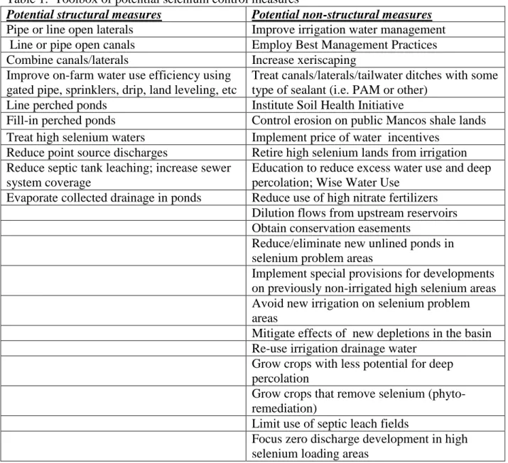
B. TOOLBOX OF POTENTIAL SELENIUM CONTROL MEASURES39 C. SELENIUM REDUCTION STRATEGY ... 40
AUTHORITIES AND LEGISLATION ... 44 UNCERTAINTIES ... 45 ADAPTIVE MANAGEMENT ... 46 REPORTING ... 46 ENVIRONMENTAL COMPLIANCE ... 46 FUNDING OPPORTUNITIES ... 46 REFERENCES... 47 APPENDIX A – MONITORING ... 51
APPENDIX B – POTENTIAL FUNDING SOURCES ... 57
vii
EXECUTIVE SUMMARY
This Selenium Management Program (Program) has been developed as part of a broad-based cooperative effort to provide water security, environmental compliance and regulatory certainty for water users in the Gunnison Basin of western Colorado. The Program is in response to the December 2009 Fish and Wildlife Service Gunnison Basin Programmatic Biological Opinion (PBO - described in Chapter 2). The Program will guide the efforts of public and private agencies and organizations in controlling selenium to meet dual objectives: complying with Clean Water Act requirements and assisting in the recovery of several endangered fish species to comply with the Endangered Species Act.
The Program will benefit water users and regional economies by protecting existing and future water uses through the acceleration of the improvement of irrigation system infrastructure and related on-farm irrigation improvements that reduce selenium (and associated salinity) loading and enhance agricultural productivity. The Program will also expand efforts to control selenium from non-agricultural sources and to improve scientific understanding of selenium fate and transport.
Selenium is a trace element that can accumulate in food chains and lead to reproductive failure and adverse impacts in fish and wildlife. Selenium is found in Mancos shale, a geological
formation common in the lower Gunnison Basin. Deep percolation of water from unlined canals, laterals, and agricultural and domestic irrigation can mobilize selenium from Mancos-derived soils and transport it to area streams and rivers. Upstream from the major irrigated areas in the lower Gunnison and Uncompahgre River Basins, selenium concentrations are generally less than 1 part per billion (ppb), but downstream from irrigated areas, the selenium concentrations in surface waters can exceed 4.6 ppb (dissolved), the state instream standard for protection of aquatic life.
Although selenium levels in the lower Gunnison and Uncompahgre rivers and several tributaries exceed Colorado water quality standards, there is strong statistical evidence that there is a downward trend in selenium concentrations and loads over the last 20 years. To date, activities associated with the following programs -- Colorado River Basin Salinity Control Program, National Irrigation Water Quality Program and the Selenium Task Force -- as well as basin-wide changes in land and water use have reduced selenium loading in the Lower Gunnison Basin. According to the Fish and Wildlife Service, several federally listed endangered fish, including the Colorado pikeminnow and razorback sucker, have been adversely impacted in the Gunnison River by water quality and other habitat issues. These issues are generally associated with historical water development in the basin. Thus, the potential for conflicts between water
development and the Endangered Species Act has developed. This Program is designed to minimize such conflicts by meeting clean water and endangered species act requirements while allowing water development to continue.
This report provides background justification for developing the Program (Chapter 2), the linkages between selenium and the health of fish and wildlife and between selenium loading and water quality trends (Chapter 3). It details the components of an Action Plan, which is the core of the Program (Chapters 4 and 5) and discusses monitoring needs, potential funding sources for implementation, and program activities (Appendices A-C).
1
CHAPTER 1—INTRODUCTION
A. PURPOSE
The purpose of this document is to describe the Selenium Management Program (Program). The Program is designed to reduce selenium concentrations in the lower Gunnison River Basin of western Colorado to assist in the recovery of federally listed endangered fish and to improve basin water quality. Implementation of the Program should ensure that selenium levels in the Gunnison River and Colorado River do not impede the achievement of recovery goals and the eventual downlisting and/or delisting of endangered fish. Successful steps towards the recovery of endangered fish species benefit water users and regional economies by providing Endangered Species Act compliance for existing and future water use.
In the 2009 Programmatic Biological Opinion (PBO), discussed later in this report, it is stated that ―Reclamation will develop and implement a Selenium Management Program (SMP), in cooperation with the State of Colorado and Gunnison River basin water users to reduce adverse effects of selenium on endangered fish species in the Gunnison and Colorado rivers…‖
The Program has been developed as a joint public/private partnership of agencies, organizations and water interests.1 It is a cooperative effort with substantial involvement of the stakeholders that maximizes the cost-effectiveness of federal, state and local investments while maximizing multiple benefits. The Bureau of Reclamation (Reclamation) serves in a leadership role in coordinating and managing the implementation of the Program.
B. REPORT
This report presents the framework for the Program including background material and recommended actions.
Chapters 1 & 2: Introduction material including the purpose of the report and the cooperative development of the program.
Chapter 3: Water-quality and endangered species goals are presented.
1 Includes the State of Colorado, Bureau of Reclamation, Natural Resources Conservation Service, U.S. Geological
Survey, Fish and Wildlife Service, Bureau of Land Management, Colorado River Water Conservation District, Uncompahgre Valley Water Users, Upper Gunnison River Water Conservancy District, local conservation districts, and local governments
Chapter 4: Water-quality and biological data are summarized; irrigation systems are described; and ongoing studies are presented.
Chapter 5: Potential selenium control components and funding opportunities are described along with a recommended strategy.
Appendix A-B: The water-quality monitoring program is described. Multiple potential funding sources for the Program are discussed.
Appendix C: The selenium management action plan of work activities and schedules, designed to be updated annually, is presented.
C. PROBLEM
Selenium is a trace element that can accumulate in food chains and lead to reproductive failure and other adverse impacts on fish and wildlife. The Selenium Task Force summarized early investigations into potential adverse effects of selenium on fish and wildlife resources (Selenium Task Force 2010):
―In 1983, incidences of mortality, deformities, and decreased reproduction in fish and aquatic birds were first discovered by the U.S. Fish and Wildlife Service at the Kesterson Wildlife Refuge in the western San Joaquin Valley, California, where irrigation drainage waters with high concentrations of selenium were collected. Due to concerns that
problems with selenium toxicity may not be confined to the Kesterson Refuge, in 1985, the U.S. Department of the Interior began a program to study the effects of irrigation drainage on the water quality of the Western United States.
Subsequent investigations by the National Irrigation Water Quality Program (NIWQP) and the United States Geological Survey (USGS) in 1987-88 indicated that irrigation drainage from the Uncompahgre Project along the Western Slope of Colorado, a Bureau of Reclamation (BOR) irrigation project, might be a primary source of selenium,
dissolved solids and other constituents to the Gunnison and Uncompahgre rivers, and Sweitzer Lake. Additional studies conducted in 1991-93, found that about 64 percent of water samples collected from the lower Gunnison River and about 50 percent of samples from the Colorado River near the Colorado-Utah line exceeded the U.S. Environmental Protection Agency (EPA) selenium criterion of 5 ug/L (micro grams per liter) for protection of aquatic life.‖
The Fish and Wildlife Service (Service) summarized concerns about selenium levels in the Gunnison and Colorado rivers (Fish and Wildlife Service 2009):
―Colorado pikeminnow, humpback chub, bonytail, and razorback sucker are being harmed from the continuation of discharge of selenium related to the Uncompahgre Project and other water uses in the Gunnison Basin. Approximately 60% of the selenium load measured in the Gunnison River near Whitewater comes from loading sources in the Uncompahgre River Basin (Reclamation 2006). The continued operation of the
3
Uncompahgre Project and other water uses is associated with continued loads of salt and selenium in irrigation drain-water being carried to the Gunnison River by adjacent tributaries. Selenium concentrations in designated critical habitat in the Gunnison River between Delta, Colorado and the Colorado River confluence, as well as the Colorado River downstream of the Gunnison River confluence, exceed the state water quality selenium standard for the protection of aquatic life. Selenium concentrations exceed toxic effect threshold concentrations and are indicative of reproductive impairment occurring in endangered Colorado River fish and migratory birds. Selenium from the female’s diet is incorporated into eggs, and high concentrations may result in reduced production of viable eggs, and/or post-hatch mortality due to metabolism of egg selenium by developing larval fish (deformities and altered physiology) (Lemly 2002, Sorensen 1991). Implementation of the Selenium Management Program is intended to reduce adverse effects of selenium on endangered fish by reducing selenium loads,
concentrations, and exposure to selenium.”
A toxicity threshold for selenium in whole fish of 4 parts per million (ppm) dry weight (DW)) has been recommended for the protection of freshwater fish (USDOI 1998, Lemly 1996a, Lemly 1996b, Skorupa 1998; Hamilton 2002b). The mean selenium concentration of 7.1 ppm DW was calculated for whole body fish samples (various not-endangered species) collected during 1992 from the Gunnison River Basin. Selenium concentrations in about 71% of the fish samples from the Gunnison and North Fork of the Gunnison Rivers, 64 % of the fish from the Uncompahgre River, and about 55% of the fish samples from the Colorado River exceeded the 4 ppm DW whole body fish selenium toxicity guideline.
In 1997, the Colorado Water Quality Control Commission (CWQCC) adopted a 5 parts per billion (ppb) aquatic life protection standard for total selenium (4.6 ppb dissolved) in the Gunnison River Basin. Several stream segments, including about 57 miles of mainstem
Gunnison River between Delta and the Colorado River confluence do not meet this standard, and appeared on the 1998 Clean Water Act (CWA) 303(d) list of impaired water bodies for the State of Colorado. These 57 miles, including the 100-year floodplain, are designated critical habitat for the Colorado pikeminnow and the razorback sucker. Exceedences in the mainstem Gunnison River range from 6-9 ppb. In 2002, the CWQCC adopted the 5 ppb aquatic life protection standard for selenium in the Colorado River. A 38 mile segment of the mainstem Colorado River below the Gunnison River confluence downstream to the Colorado-Utah state line was placed on the CWA 303(d) list.
D. PROGRAM GOALS
The Selenium Management Program is designed to reduce selenium levels in the lower
this goal will assist in the recovery of endangered fish, thus providing water security,
environmental compliance and regulatory certainty for water users and the citizens of the basin.
Water Quality
The initial goal of the Program as recommended in the PBO is to meet the state water-quality standard for dissolved selenium of 4.6 ppb as measured at the Whitewater Gage2 and as determined by the Colorado Water Quality Control Division methodology. In addition, the Program will endeavor to maintain or improve the existing downward trend in the lower Gunnison River selenium concentrations. The downward trend between 1986 and 2010 is depicted in Figure 7 and discussed in Section 3.B.
Endangered Fish
The long term goal of the Program is to sufficiently improve water-quality conditions to assist in the recovery of the Colorado pikeminnow and razorback sucker by reducing selenium
concentrations. Recovery happens when naturally occurring, reproducing populations are self sustaining, with all life stages present and there is natural recruitment into the adult population. The goal of the Program with respect to endangered fish in the Gunnison River is to ensure that selenium levels in the lower Gunnison and Colorado rivers do not impede the achievement of recovery goals and down-listing and delisting of endangered fish.
Water Resources
Another long-term goal of the program is to support continued water uses in the Basin. The Program fulfills a critical requirement of the PBO and thereby protects historical water uses by ensuring public and private water users benefit from regulatory certainty. The PBO and its benefits are described in Chapter 2.
5
CHAPTER 2—BACKGROUND ACTIVITIES
A. PROGRAMMATIC BIOLOGICAL OPINION
In 2009, Reclamation released a draft Environmental Impact Statement on modifying the water release patterns from the Aspinall Unit in order to assist in the recovery of downstream
endangered fish (Reclamation 2009). The Aspinall Unit consists of Blue Mesa, Morrow Point, and Crystal dams, reservoirs, and powerplants on the Gunnison River in west-central Colorado. In general, the new operations proposed include a higher spring release and moderate base flows during the remainder of the year.
Reclamation worked with the Service to evaluate the new operations under the Endangered Species Act (ESA). The State of Colorado, Colorado River Water Conservation District and water users requested that the Service and Reclamation expand their analysis beyond Aspinall Unit operations and cover effects of all public and private water uses in the Gunnison Basin, with a goal of avoiding future adversarial endangered species consultations. They requested that Reclamation and the Service prepare a programmatic biological assessment and programmatic biological opinion (PBO). Consequently the programmatic biological assessment (Reclamation 2008) and the PBO (Fish and Wildlife Service 2009) were prepared.
The PBO addresses the modified Aspinall Unit operations and in addition it addresses other public and private water uses in the Gunnison Basin. In summary, the PBO provides ESA coverage for existing and specified future water uses and depletions in the Gunnison River Basin, as well as completes ESA consultation on the Dallas Creek and Dolores Projects. Two main elements of the PBO are:
The reoperation of the Aspinall Unit and
The preparation and implementation of the Selenium Management Program.
The Program, as described in the PBO, calls for reducing selenium levels in the Gunnison and Colorado rivers. The Service describes the selenium issue in the PBO as follows:
―The ongoing operation of irrigation projects and other water uses in the basin will continue to contribute selenium to the Gunnison and Colorado Rivers at levels that adversely affect the endangered fishes and their designated critical habitat and are inhibiting the survival and recovery of the endangered fishes. Reclamation will develop and implement a Selenium Management Program (SMP), in cooperation with the State of Colorado and Gunnison River
basin water users to reduce adverse effects of selenium on endangered fish species in the Gunnison and Colorado rivers (see Effects of the Proposed Action section). The SMP will incorporate and accelerate ongoing selenium reduction efforts in the Uncompahgre Valley and other areas of the Gunnison Basin and will add several new elements. The overall long-term goal of the program is to assist in species recovery per the Recovery Goals. The SMP will use the best available scientific information for all elements of the program. Elements of the SMP will include:
Accelerated implementation of salinity/selenium control projects for irrigated agriculture
Reduction of other non-point source selenium loading Technology development
Water-quality monitoring
Monitoring of endangered fish populations
Coordination with lower Gunnison River Basin watershed management plan Regulatory support
Public information and education Adaptive management
Institutional support‖
Successful implementation of the Program has been recognized as providing local and regional benefits as well as avoiding water-quality and regulatory problems. In general, the PBO provides the following benefits to the basin’s public and private water uses:
• Provides ESA compliance, especially ―take‖ coverage, for existing and new private/public water uses, including the Aspinall Unit and the Uncompahgre, Smith Fork, Paonia, Fruitgrowers, Bostwick Park, and Dallas Creek Projects. The PBO recognizes that depletion of water and existing selenium concentrations harm the endangered fish. Harm is considered ―take‖ of an endangered species and this ―take‖ is covered by the PBO as long as certain measures are
implemented, including the Program.
• Shifts responsibility from individual water users to the Colorado River
Endangered Fish Recovery Program to address depletion impacts to endangered species.
• Provides water security, environmental compliance and regulatory certainty in the Gunnison Basin. The PBO greatly reduces the chances of major conflicts
between the ESA and water uses in the basin.
• Provides ESA compliance for the Upper Gunnison Subordination and provides compliance for depletions from new augmentation contracts throughout basin. • Assists in endangered fish recovery--which supports continuing and future water
7
• Enhances or supplements existing programs and thus may facilitate improvement of irrigation systems, crop production, and local economies; and may reduce operation and maintenance costs of irrigation systems and make more efficient use of water.
• Facilitates ESA compliance for future Clean Water Act 402 and 404 permits, land use permits, or other regulatory approvals.
• Completes ESA compliance for the Dolores Project by offsetting mainstem depletions.
• Improves water quality for many uses in Colorado and downstream.
Because implementation of the Program is a key part of the PBO, it is essential that the Program be fully implemented in a timely manner in order for Reclamation and water users in the basin to comply with the ESA. If the assessment from annual progress reports indicates that the Program, as specified in the PBO, has not been implemented as proposed, Reclamation will be required to reinitiate consultation to specify additional measures to be taken by Reclamation or the Recovery Program to avoid the likelihood of jeopardy and/or adverse modification of critical habitat for depletions and water quality. Also, if the status of endangered fish species has not sufficiently improved, as determined by the Service in a formal ―sufficient progress finding‖ under
provisions of the Recovery Program, Reclamation will be required to reinitiate consultation3. The PBO calls for the Program to include goals, timeframes, and a Long Range Plan (termed the Selenium Management Action Plan in this report). This Plan (Appendix C) is to include
implementation schedules, benchmarks, responsible or contributing entities, monitoring needs, and coordination with ongoing Recovery Program Activities (Fish and Wildlife Service 2009).
B. RECOVERY PROGRAM
In 1988, the Upper Colorado River Endangered Fish Recovery Program (Recovery Program) was established to assist in the recovery of four species of endangered fish found in the Colorado River: the humpback chub, bonytail, Colorado pikeminnow, and razorback sucker. The
pikeminnow and razorback are found in the Gunnison River. The Recovery Program; which is a partnership of local, state, and federal agencies, water and power interests, and environmental groups; provides ESA compliance for continued operation of water and power projects in accordance with project purposes.
The goal of recovery is to achieve natural, self-sustaining populations of the endangered fish so they no longer require protection under the ESA. The Recovery Program will monitor
3 Re-initiation of consultation essentially means the ESA compliance process would be redone, possibly with new
endangered fish populations in the Gunnison River to determine responses to various recovery activities and the implementation of the Program. In addition the program will collect fish tissue samples for selenium analysis. A Study Plan (Recovery Program 2011) has been prepared to recommend to the Recovery Program monitoring and/or research projects necessary to evaluate effects of the proposed operations of the Aspinall Unit described in the PBO, to determine how those operations improve habitat contributing to recovery of the endangered fishes, and to evaluate effects on critical habitat in the Gunnison River and in the Colorado River from the Gunnison River confluence to Lake Powell.
C. PREVIOUS AND ONGOING ACTIVITIES RELATED TO
SELENIUM CONTROL
As discussed later in this report, infiltration of water into selenium and salt rich soils and formations is the primary factor in both salt and selenium loading in the Gunnison Basin. To date, activities associated with the following programs --- Colorado River Basin Salinity Control Program, National Irrigation Water Quality Program and the Selenium Task Force --- as well as basin-wide changes in land and water use have reduced selenium loading in the Lower Gunnison Basin.
Colorado River Basin Salinity Control Program
The Colorado River Basin Salinity Control Program (Salinity Program) is designed to reduce upper Colorado River basin salt loading primarily for the benefit of water users in the lower basin states of Arizona, California, and Nevada. Salinity-control techniques adopted by the Salinity Program are generally thought to reduce selenium loading because seepage and deep percolation of water into the local Mancos Shale and associated soils is the primary source of both salt and selenium loading. The 1974 Salinity Control Act, as amended, authorizes the Department of the Interior (Reclamation and Bureau of Land Management [BLM]) and the Natural Resources Conservation Service (NRCS) to undertake actions to reduce salinity loading in the upper basin. Generally, Reclamation works to improve the irrigation water delivery systems (typically known as the ―off-farm‖ systems), NRCS works with individual landowners to improve on-farm irrigation practices and the BLM addresses runoff from public lands. Although the 1996 amendment eliminated the mandated USDA authorities under the Colorado River Basin Salinity Control Act, Environmental Quality Incentives Program (EQIP) authorities include water-quality improvements such as salinity control and continue to govern NRCS’s implementation of salinity control assistance to eligible producers on eligible land.
In the mid 1970’s, Reclamation began studies of the Lower Gunnison Basin Unit (LGBU) as directed by the Salinity Control Act. Investigations focused in the Uncompahgre Project
9
area because of its highly concentrated salt loading. A plan was developed for lining canals and laterals east of the Uncompahgre River and eliminating use of open ditches for winter stock water deliveries throughout the Project area.
Reclamation implemented the ―Winter Water Program‖ in the Uncompahgre Valley between 1992 and 1995. This effort eliminated flows in 407 miles of canals and laterals during the late fall and winter that had been required for livestock watering and replaced that source with piped domestic water deliveries. The project was constructed in cooperation with the Uncompahgre Valley Water Users Association (UVWUA) and local domestic water providers. This reduced salinity loading by an estimated 41,330 tons/year and, most likely, selenium loading by some un-estimated amount.
In 1995, further amendments to the Salinity Control Act provided for Reclamation’s ―Basinwide Program‖ which selects off-farm projects proposed by irrigation companies and other water user entities on a cost-competitive basis. In the early years of that program, proposals for the
Uncompahgre Valley were not cost effective and thus not selected for funding. Later, others assisted in providing cost sharing which allowed funds to be secured for a number of projects in that area.
The NRCS provides cost-share assistance to agricultural producers who voluntarily implement improved land management and on-farm irrigation practices that reduce salt loading.
Participants are provided incentive payments and share in the cost for measures that reduce on-farm salt loading. NRCS also provides technical assistance to producers to plan, design, and install these more efficient water systems. Examples of NRCS activities include use of gated pipe and sprinkler systems for field irrigation, land leveling for more efficient irrigation, and development of irrigation water management plans. The NRCS works in partnership with Conservation Districts to assist farmers to install improved irrigation systems in the Lower Gunnison salinity control area under the various Colorado River salinity control initiatives. There is a greater trend toward conversion of existing improved surface systems to highly efficient, advanced irrigation technology (AIT), in particular center pivot sprinkler systems. Currently, this trend is primarily occurring in Delta County of the project area. As mainstem delivery systems are piped it usually creates pressurized flow delivery systems encouraging the conversion of existing improved surface on-farm systems to AIT.
On-farm salinity control in the Lower Gunnison area has been primarily made possible through the EQIP and the Parallel Program (PP). The PP is terminating and the new Basin States Program (BSP) that was authorized in the 2008 Farm Bill, Public Law 110-246, that amended the Salinity Control Act, will be another potential source of funding. The emphasis of the BSP will be to fund improved land management and irrigation practices that do not qualify under EQIP and small off-farm canal and lateral delivery systems that are too small to compete in the Basinwide Program’s cost-competitive process.
On-farm Gated Pipe
The BLM has a program on public lands to improve vegetation cover, assist in better use of onsite precipitation, and facilitate stronger plant root systems. In turn, a more stable runoff regime and reduced soil loss should result and improve water quality. The BLM is revising the Resource Management Plan for BLM-administered lands within the Uncompahgre Planning Area. The plan details the current state of resources and guides management actions for the next twenty or more years under the BLM’s dual mandate of multiple use and sustained yield. As part of the process, the BLM will consider a set of alternatives for addressing public land contributions to selenium loading in aquatic environments. Activities identified as having the greatest potential to impact selenium transport include recreation, grazing, fluid mineral development, and land disposal. For each of these activities, a preferred alternative will be selected that balances resource protection, including selenium control, with the impacts of a growing population and expanding urban interface in accordance with the National
Environmental Policy Act and the ESA. For more information about the Uncompahgre Resource Management Plan, please visit: http://www.blm.gov/co/st/en/fo/ufo/uncompahgre_rmp.html.
11
Mancos Shale lands managed by Bureau of Land Management
National Irrigation Water Quality Program
The National Irrigation Water Quality Program (NIWQP) was initiated in 1986 in response to concerns about the impact of elevated levels of selenium in western waterways. Data was collected between 1987 and 2003 in the Gunnison River Basin. Water, sediment, food chain items, fish, birds, and eggs were sampled for many potential contaminants including selenium, which was the major concern. Based on the data, the combined lower Gunnison River Basin and Grand Valley in western Colorado was one of 5 areas selected in the western United States as significant selenium problem areas for fish and wildlife that warranted remediation.
The NIWQP began planning for remediation in the lower Gunnison Basin in 1994. In1999, a proposal was formulated by the UVWUA and NIWQP to fund a demonstration project in the Montrose Arroyo area, southeast of Montrose. The purpose of the project was to show how the NIWQP and the Salinity Program could work cooperatively to reduce both selenium and salinity loading. This project, later known as Phase 1 of the East Side Lateral Project, was very
successful, reducing selenium loading by 27% and salinity loading by 11%. Based on these results, several members of the Gunnison Basin Selenium Task Force pursued Congressional write-ins to the NIWQP budget in the early 2000’s to support Phases 2 and 3 of the East Side
Lateral Project. Those phases were eventually funded by the Salinity Program and NIWQP with construction completed in 2011.
Selenium Task Force
In July 1997, the State of Colorado Water Quality Control Commission (WQCC) amended the Classifications and Numeric Standards for the Lower Gunnison and Lower Dolores River
Basins. These amendments included the adoption of a new chronic water-quality standard of 4.6 ppb for dissolved selenium and the adoption of temporary modifications for selenium standards. The adoption of the new standard meant that a number of segments in the lower Gunnison Basin were placed on the State of Colorado's 303(d) List of Impaired Waters which requires the
development of Total Maximum Daily Loads (TMDLs) for selenium.
In February 1998, the Gunnison Basin Selenium Task Force was formed to address exceedence of the selenium standard in a number of segments in the lower Gunnison Basin and to assist in developing local solutions to reduce selenium loading in affected segments. The Selenium Task Force is "a group of private, local, state and federal interests committed to finding ways to reduce selenium in the affected reaches while maintaining the economic viability and lifestyle of the lower Gunnison River basin" (Selenium Task Force 2010). Following its formation, the Selenium Task Force immediately joined forces with the NIWQP.
In 2006, the NIWQP and Reclamation’s Technical Assistance to States Program working in conjunction with the Selenium Task Force produced a report entitled ―Evaluation of Selenium Remediation Concepts for the Lower Gunnison & Lower Uncompahgre Rivers, Colorado‖ (Reclamation 2006). This report documented a planning process that developed and evaluated remediation concepts and provided the Selenium Task Force and other decision makers with information needed to assess the potential for significantly reducing selenium loading. It serves as a significant resource on background and historical selenium reduction planning efforts for formulation of the Program.
Today, the Selenium Task Force meets and works collaboratively to address selenium loading in affected reaches. Members of the Selenium Task Force provide technical expertise, monitoring and evaluation of projects, grant writing expertise, and a forum for education and outreach. Background information is available at (http://seleniumtaskforce.org/). Members include:
13 City of Delta, CO
City of Montrose, CO City of Grand Junction, CO
Colorado Department of Health and Environment Colorado Division of Water Resources
Colorado Division of Parks and Wildlife Delta Conservation District
Shavano Conservation District
Colorado River Water Conservation District Colorado Soil Conservation Board Colorado State University Extension Colorado Water Institute
Commercial farmers, ranchers, and dairymen
Delta County Commissioners Delta County Health Department
High Country Citizens Alliance / Sierra Club Montrose County Commissioners
Natural Resources Conservation Service Towns of Hotchkiss, Paonia, CO U.S. Fish and Wildlife Service U.S. Bureau of Reclamation U.S. Bureau of Land Management
Uncompahgre Valley Water Users Association U.S. Geological Survey
Over its years of existence, the Selenium Task Force and its members have been effective in securing funding for various selenium-related studies and demonstration projects. As mentioned above, members have secured funding for the NIWQP and from Colorado’s Non-Point Source Program (NPS Program) (CWA Section 319 funds) to support construction of the East Side Lateral Project. The Selenium Task Force is presently preparing a Lower Gunnison River Basin Selenium Watershed Management Plan to help to assist in the implementation of selenium reduction projects with NPS funds in order to meet selenium water-quality standards. It is anticipated that the Watershed Plan will mirror activities displayed in the Program Action Plan (see Section 5).
Major Accomplishments
Major accomplishments of the aforementioned programs that are believed to have reduced selenium loading in the lower Gunnison River Basin are listed below. Limited information is available to provide good estimates of selenium load reductions, so, although selenium is likely reduced by these accomplishments, load reduction estimates are not generally provided4.
1995: The ―Winter Water Program‖ eliminated the carriage of water in Uncompahgre Project canals and laterals during the non-irrigation season and thus reduced seepage and subsequent salt and likely selenium loading. Estimated salt load reduction was 41,330 tons/year.
2000: The Montrose Arroyo Demonstration Project placed 8.5 miles of open laterals into pipe reducing salt and selenium loading and allowing documentation of the effects in a published U.S. Geological Survey (USGS) report. The USGS data collection produced an estimated selenium load reduction of 210 pounds/year and salt load reduction of 2,500 tons/year.
2004 thru early 2011: Following the Montrose Arroyo demonstration project, approximately 47 additional miles of laterals in the Uncompahgre Valley have been
4 As discussed later in this report, although there are indications of a relationship between salt and selenium loading,
the actual fate and transport relationships are not fully understood at this time. So no numeric selenium reduction can be deduced from the predicted salinity reductions for any of these reported accomplishments.
placed in pipe or lined to reduce salt and selenium loading and another 4 miles are approved and funded. Estimated salt load reduction is 12,082 tons/year.
1988-2010: Through fiscal year 2010, the NRCS reports implementing 57,588 acres of on-farm irrigation system improvements in the lower Gunnison Basin with an estimated salinity reduction of 105,502 tons/year. An estimated 49,705 acres are improved flood systems, 6,765 acres are sprinkler systems, and 1,067 acres are micro-spray or subsurface drip systems. These numbers do not include work done prior to 1989, and none would include work done by landowners without federal assistance or through other programs or with other non-salinity funds (NRCS 2011).
1988-2010: The BLM implemented Best Management Practices to reduce erosion of saline and selenium-bearing soils.
2010-2011: Approximately 9.8 miles of canal and associated laterals in the North Fork and Smith Fork drainages were piped to reduce salinity loading. Estimated salt load reduction is 4,588 tons/year.
2011: Six additional lower Gunnison Basin projects to pipe irrigation canals and laterals were selected under Reclamation’s 2010 Basinwide Program FOA. Agreement
15 Unlined lateral being placed in pipe.
CHAPTER 3--BACKGROUND DATA
A. SELENIUM LOADING
Selenium occurrence in the lower Gunnison Basin is a function of geologic formations and properties of those formations. Occurrence of selenium in ground and surface water in dissolved forms is a function of oxidizing or reducing conditions which exist as a product of the
biogeochemical environment and physical processes such as coprecipitation and adsorption. These processes are complex and governed by many physical and geochemical factors of which many are not fully understood. A summary of the general factors controlling the sources of selenium and its mobilization are presented here. A more extensive accounting of these factors can be found in the work cited throughout this report.
Selenium enrichment of geologic materials occurred during the Cretaceous age and was related to volcanic eruptions of element-rich gases and ashes (Butler and others 1996). During the
Cretaceous age, a vast interior seaway called the Cretaceous Sea covered most of North America. The depositional setting in this seaway was an organic rich environment capable of reducing selenium in the crystalline structure of sulfide minerals (Coleman and Delevaux 1957).
Additional sources of selenium to the seaway may have come later in the Cretaceous age as the seaway evolved and became an interior sea. Trace elements such as selenium and major ions were concentrated in the sediments as the interior sea eventually receded. The geologic
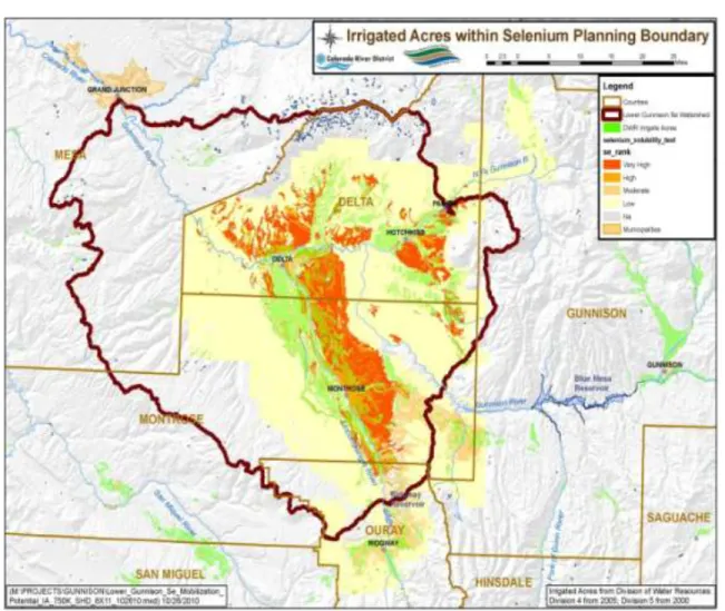
formation in the lower Gunnison Basin associated with the Cretaceous Sea is called the Mancos Shale Formation. Outcrops of this formation are shown in Figure 1. Figure 2 rates the potential of lands from a very high to low potential to contain soluble selenium. Mancos Shale outcrops tend to occur in the valleys of the lower Gunnison Basin. This is as a result of regional uplift of the Uncompahgre Plateau in the south western portion of the basin, the Black Canyon of the Gunnison uplift in the central region of the Basin, and the West Elk Mountains to the east. Geologic ages associated with the uplift sequences are older than the Mancos Shale and are not associated with the Cretaceous Sea. Erosion rates were higher in areas of uplift and the younger formations, such as the Mancos Shale, were consequently eroded away at a faster rate than those in the Valley floors. Selenium occurs in other geologic formations but is most prevalent in the Mancos Shale as a result of the unique conditions and timing of events that occurred during the Cretaceous period. The amount of total selenium contained in different areas of the Mancos Shale Formation is highly variable and governed by the depositional environment during formation. Butler and others (1996) found that concentrations of selenium in Mancos Shale Bedrock were higher in samples cored near ash layers. They also found that weathered layers of Mancos Shale (residuum and alluvium) were higher in total selenium, perhaps as a result of the preferential displacement due to adsorption or capillary effects.
17
Figure 1. Map showing approximate areal extent of surface outcrops of Mancos Shale highlighted in brown in the lower Gunnison Basin and portions of western Colorado.
Selenium enrichment in ground and surface waters has always occurred via the same physical and chemical processes; however, modern land use practices have changed the rate and quantity at which enrichment occurs. Selenium is sourced from the soils and parent material and
mobilized by waters of various origins. The geochemical processes that govern the rate of selenium mobilization are complex, but are generally tied to source abundance and redox state. In the presence of low oxygen conditions, selenium will be reduced and exist in a less mobile form; whereas, oxic conditions will create more mobile forms of selenium.
Figure 2. Primary selenium source areas in Gunnison Basin with potential to load selenium rated from very high to low.
Anoxic conditions occur when oxygen availability is limited. Oxygen is limited when microbial demand exceeds availability. This is common in, but not limited to, some depositional
environments such as oxygen deprived ground water, and organic rich but poorly drained soils such as wetlands. Through the span of geologic time, uplift and erosion has exposed reduced forms of selenium in the Mancos Shale Formation to meteoric and applied sources of water. The reducing environment that existed during deposition can be shifted to an oxidizing environment as a result. Sources of applied water identified here generally consist of irrigation, residential, and industrial water use. Applied water accelerates the process in which anoxic environments become oxic. The water provides oxygen (and potentially other oxidizing agents), resulting in a higher potential to mobilize selenium than was otherwise present prior to water application. In the lower Gunnison Basin, the type of applied water that has the most impact on selenium mobilization is irrigation water for agriculture. Precipitation rates in the lower valley are
typically on the order of 6-12 inches (Doesken 2011), whereas irrigation rates add an additional 24-60 inches ( Written Communication, Uncompahgre Valley Water Users Association 2011).
19
Additionally, canals and laterals used to deliver the irrigation water to agricultural fields can seep and add more oxygen rich water to the ground water system. Approximately 170,000 acres of irrigated land exists in the lower Gunnison Basin of which approximately 57,000 irrigated acres are situated on Mancos Shale outcrops (Tweto and Ogden 1976; Techni Graphic Systems, Inc. 2003).
Water from unlined laterals percolates into the ground water and picks up selenium.
Other sources of water that may have an increasing impact on selenium mobilization are industrial and residential sources. Industrial applications are primarily limited to energy extraction in the form of natural gas, oil, and coal bed methane. A byproduct of these types of energy development is water produced as a result of drilling and extraction. The water may be displaced to evaporation ponds or local drainages. This displaced water could move into a regional ground water system or increase selenium yield via increased sedimentation rates. The quantity of selenium released from activities associated with energy development is not fully understood; however, energy development in the lower Gunnison Basin is limited.
Residential sources of water to the ground water system typically result from individual septic disposal systems (isds’s) and turf irrigation. Mayo (2008) found that there is a reduction in ground water recharge when converting previously irrigated agricultural land to residential land. These results suggest a decreased potential for salinity and perhaps selenium mobilization as a result of this type of land use change. The impact to selenium mobilization potential from converting previously non-irrigated land to residential land and septic systems is not fully understood. However, the addition of water for landscape irrigation, ponds, runoff from hard surfaces, and water from septic systems on lands that have not been irrigated previously, are likely to introduce potential new sources for both salinity and selenium loading.
New residences in Mancos Shale Area. Precipitated salt appears as white covering of soils. Irrigation history affects selenium levels in soils. According to Fisher (2003) ―Soil mapping and sampling of Mancos derived soils determined that soils that have never been irrigated contain an average of 34 times the amount of selenium remaining in irrigated soils that have been leached; also of significance is that soluble selenium levels do not increase with depth in irrigated soils; this correlation supports the hypothesis that a large part of the original soluble selenium, pre-irrigation, has been leached from the soil profile.‖
Fisher (2003) identified potentially important sources of selenium loading: ―…deep percolation irrigation water (both agricultural and domestic); septic system drainages; seepage from ponds, wetlands, and canals; the natural erosion of Mancos Shale, and soils derived from the Mancos shale; and the irrigation of golf courses, parks, cemeteries, and urban lawns.‖
21
B. WATER QUALITY AND TRENDS
Selenium levels are monitored by various agencies and organizations in the Gunnison Basin. For the Program, the key monitoring point is the USGS Gunnison River gage at Whitewater. The primary objective of the selenium monitoring program in the lower Gunnison Basin is to document selenium trends in support of endangered species issues and state standards, TMDL development and implementation, modeling efforts, and fish studies.
The goal of monitoring is to build a more robust database for salinity and selenium that will provide the basis for better statistical analysis of salinity and selenium using regression modeling at various scales. The information gained from the models will enhance decision making
processes by improving planning models and scientific understanding.
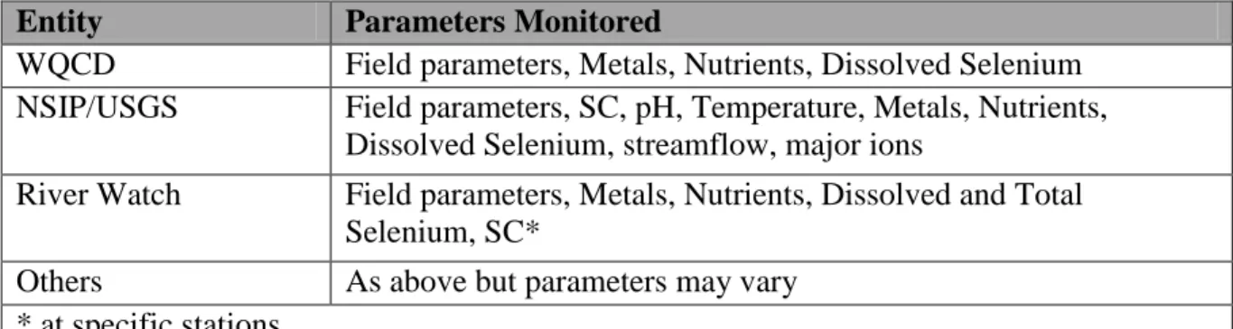
The strategy is to expand and optimize the existing water-quality monitoring network in the lower Gunnison Basin in partnership with a variety of stakeholders. For example, the Colorado River Water Conservation District, the Colorado River Salinity Control Forum, the USGS, and Reclamation have teamed up to add three real-time specific conductance and temperature monitors at existing USGS real-time flow stations. Knowing real-time continuous specific conductance allows for the development of correlations between flow and major ion concentrations. To further leverage these data, there is coordination with the USGS, River Watch, and the State Water Quality Control Division (WQCD) to acquire selenium samples at these and other existing monitoring sites. With a well-designed program, additional selenium samples collected at strategic times and locations will be cost-effective and provide vital information that can be used for trend analyses, CWA compliance, listing/de-listing, TMDL development and implementation, and support modeling efforts and endangered fish studies. Additional information on monitoring is included in Appendix A.
Data presented in this section were collected by the USGS and can be accessed at http://co.water.usgs.gov/. Additional data was available for sites listed in this analysis
http://rmgsc.cr.usgs.gov/cwqdr/Piceance/SPiceance.shtml but was not included because only USGS data was used for the trend analysis presented in this section. USGS data was used exclusively for the trend analysis to eliminate potential bias from differing sampling techniques, laboratory methods, and detection limits that could indicate a false trend. Dissolved selenium is defined by the State of Colorado Department of Public Health and Environment as the portion of total selenium in unfiltered water that passes through a 0.45 micron filter. Selenium
concentrations described herein were processed by the USGS using a 0.45 micron filter and all results are presented as dissolved. Specific methods used to collect, preserve, and analyze these data are available in the USGS National Field Manual http://water.usgs.gov/owq/FieldManual/ and on the USGS National Water Quality website http://nwql.usgs.gov/.
Selenium data collected at two USGS streamflow gaging stations are presented in this section. The two stations are the Gunnison River near Grand Junction (Whitewater) and the Colorado
River at the Colorado-Utah State Line (State Line)5. These stations represent the integration of selenium from multiple land use types. The majority of selenium from Western Colorado passes these two stations. Selenium loads (selenium concentration multiplied by streamflow with units of pounds per unit of time) at the State Line gage represent roughly 60% of the selenium load that enters Lake Powell annually. Both stations are outflow points for critical habitat segment of endangered fish species. The gaging stations are also end points for stream reaches that are on the State of Colorado 303(d) list of impaired streams for selenium. The State of Colorado’s chronic standard for aquatic life warm water class one is 4.6 ppb. If the 85th percentile of
selenium values in a representative data set exceeds 4.6 ppb, then the reach is out of compliance and is assigned to the State of Colorado 303(d) list.
Selenium concentrations analyzed periodically from 1986-2008 are shown in Figures 3 and 5. This period was chosen because it begins with the completion and filling of Ridgway Reservoir and coincides with the onset of the NRCS cost-share for irrigation system improvements for salinity control and Reclamation’s salinity program. These events are significant in regards to the selenium trend analysis results presented later in this section. Several patterns in the distribution of dissolved selenium concentration exist at each station. Selenium concentrations at both stations tend to vary inversely with streamflow. When streamflow levels are high, selenium concentrations tend to be lower and the opposite is true for low streamflow levels. At both stations, the lowest period of streamflow was in 2000-2005. Selenium concentrations at Whitewater were highest during 2000-2005 and selenium concentrations at State Line were approximately the same as the highest historical concentrations (late 1980’s) for the period. Selenium at State Line appears to follow a similar temporal distribution as Whitewater.
Generally, when selenium concentrations are high at Whitewater, they are high at the State Line. This indicates that selenium levels at Whitewater are controlling selenium levels at the State Line to some degree and processes controlling selenium at each station are similar. Raw data from Figures 3 and 5 show a range of selenium concentration from 1 to 16.2 ppb at Whitewater and from 1 to 11 ppb at the State Line.
While not evident from Figures 3 and 5, selenium concentrations at both stations are typically higher during the non-irrigation season (November to March) when ground water is a larger component of streamflows. Lower concentrations during the irrigation season are a function of snowmelt flows providing dilution and release of stored water during the growing season (April to October). During the non-irrigation season, less water is available to dilute selenium enriched ground water entering the stream system.
Dissolved selenium loads are shown in Figures 4 and 6 as daily loads (lbs/d) that were calculated from periodic samples. Selenium load varies with streamflow and is generally higher during wetter periods than dry periods. Butler (1996) reported that the lower Gunnison Basin was the source of approximately 43% of selenium load at the State Line for water years 1991-92. Leib (2008) found the lower Gunnison Basin contributed around 52% of the selenium load at the State Line for the period 1997-2006. The residual loads from each study were attributed to the Grand
5 USGS Gaging Station No.9152599, Gunnison River near Grand Junction (Whitewater gage)
23
Valley, and to a lesser extent (7-9%), areas draining land upstream of the Grand Valley. Median loads shown in Figures 4 and 6 indicate that about 52% of the selenium load at the State Line is from the lower Gunnison Basin. Selenium loads for both stations were approximately 15% higher for water-years 1986 to 1997 indicating a possible trend in dissolved selenium.
Mayo and Leib (2011) analyzed trends in dissolved selenium at Whitewater and the State Line for the period 1986 to 2008. This period brackets the period of major selenium and salinity control work in the lower Gunnison Basin and Grand Valley. Mayo used a streamflow adjustment technique to account for fluctuations in streamflow. This was done to account for fluctuations of selenium concentration and load that may occur as a result of dilution or trends in streamflow. When streamflow is taken into account, the remaining variability in the selenium data can be associated with possible land use or selenium/salinity control measures in the area of interest. This method uses regression techniques to estimate trends in dissolved selenium
concentrations and loads from a normalized annual hydrograph for the period of record. The regression represents the average condition for the period analyzed and will not represent wet or dry periods as well as the long term period analyzed.
The trend analysis was considered to primarily represent changes in the lower Gunnison Basin and the Grand Valley due to the fact that selenium levels above the lower Gunnison Basin and the Grand Valley are typically below or near detection limits. The low selenium concentrations make further analysis unnecessary. Butler (1996) reported selenium concentrations from the upper Gunnison Basin (USGS streamflow gaging station 0912800, Gunnison River below Gunnison Tunnel) were all below current detection limits (1 ppb). Leib (2008) reported median dissolved selenium concentrations above the Grand Valley (USGS streamflow gaging station 0905500, Colorado River near Cameo) to be 0.5 ppb for the periods 1994-95 and 2005-06. Due to the low concentration of dissolved selenium upstream from the lower Gunnison Basin and Grand Valley, no analysis of selenium trends was done.
The trend analysis showed decreasing trends in selenium concentration and load at both stations during the study period. Selenium concentrations at the 85th percentile went from 7.2 ppb to 5.1 ppb at Whitewater and from 7.8 ppb to 4.6 ppb at the State Line. Loads at Whitewater decreased 28.6% from about 23,000 to 16,560 pounds annually. Selenium loads at the State Line decreased 40.3% from 56,600 pounds to 33,600 pounds annually.
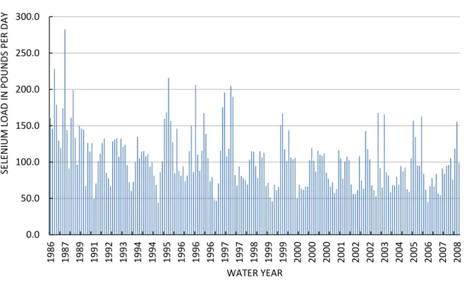
The calculated trend in selenium concentration from 1986 to 2008 is shown in Figure 7 as the ―flow adjusted trend‖ line. It has been extrapolated to show the potential future trend for the years 2009-2016. The trend is flow adjusted which means the trend in selenium concentration appears as it would if the variability due to variations in streamflow is removed. The solid black trend line shows a reduction in selenium concentration of approximately 2 ppb between 1986 and 2008 or about 29%. These results may not be reflected in unusually wet or dry years and are only representative of the average hydrologic condition for the period of record analyzed. The green line represents the 85th percentile for the last 5-year period as it would be calculated by the
0 2000 4000 6000 8000 10000 12000 14000 16000 18000 0 2 4 6 8 10 12 14 16 18 1985 1987 1989 1991 1992 1993 1994 1995 1996 1996 1997 1997 1998 1998 1999 2000 2000 2001 2002 2003 2003 2004 2005 2006 2008 ST RE AMFLOW IN CU BIC FE ET P ER SE COND SE LE N IUM IN M ICROG RAMS PE R L IT ER WATER YEAR
Gunnison River Near Grand Junction Streamflow Gaging Station
Diss Se Streamflow
State of Colorado to determine impairment as defined by the EPA. The 2010 value was 6.0 ppb. The State’s selenium standard is 4.6 ppb.
Figure 3. Dissolved selenium concentrations from water years 1986-2008 for the Gunnison River near Grand Junction (Whitewater) streamflow gaging station.
25 0 20 40 60 80 100 120 140 160 1985 1987 1988 1990 1991 1992 1993 1994 1995 1996 1996 1997 1997 1997 1998 1998 1999 1999 2000 2001 2001 2002 2003 2003 2004 2005 2005 2006 2008 SE LE N IUM LOAD, P OUNDS PE R DAY WATER YEAR
Gunnison River Near Grand Junction Streamflow Gaging Station
Figure 4. Selenium load from water years 1986-2008 for the Gunnison River near Grand Junction (Whitewater) streamflow gaging station.
0 5000 10000 15000 20000 25000 30000 35000 40000 45000 0.0 2.0 4.0 6.0 8.0 10.0 12.0 1986 1987 1989 1991 1992 1994 1994 1995 1996 1996 1997 1997 1998 1998 1999 2000 2000 2001 2001 2002 2003 2004 2005 2006 2007 ST RE AMFLOW IN CU BIC FE ET P ER SE COND SE LE N IUM CONCE N TRAT ION IN M ICROG RAMS PE R L IT ER WATER YEAR
Colorado River at Colorado Utah State Line Streamflow Gaging Station
Diss Se Streamflow
Figure 5. Dissolved selenium concentrations from water years 1986-2008 for the Colorado River at Colorado Utah state line streamflow gaging station.
27 0.0 50.0 100.0 150.0 200.0 250.0 300.0 1986 1987 1989 1991 1992 1993 1994 1994 1995 1996 1996 1996 1997 1997 1998 1999 1999 2000 2000 2000 2001 2002 2002 2003 2004 2005 2006 2007 2008 SE LE N IUM LOAD IN POUNDS PE R DAY WATER YEAR
Colorado River at Colorado Utah State Line Streamflow Gaging Station
Figure 6. Selenium load from water years 1986-2008 for the Colorado River at Colorado Utah state line streamflow gaging station.
-6000 -5000 -4000 -3000 -2000 -1000 0 1000 2000 3000 4000 5000 6000 1986 1987 1988 1989 1990 1991 1992 1993 1994 1995 1996 1997 1998 1999 2000 2001 2002 2003 2004 2005 2006 2007 2008 2009 2010 2 4 6 8 10 12 14 16 18 20 22 24 26 1986 1988 1990 1992 1994 1996 1998 2000 2002 2004 2006 2008 2010 2012 2014 2016 A n n u al Fl ow cu b ic fe et p e r secon d 85 th P e rcen ti le Se le n iu m Co n cen tr ati on p p b Date
Fig 7 Gunnison River near Grand Junction 85th Percentile Concentrations
Flow Adjusted Trend 85th by year 85th by 5 years Thomas 2007 Annual Flow
29
C. BIOLOGICAL DATA
Historical information on the Gunnison River’s fish populations is limited and was summarized by Burdick (1995):
―Jordan (1891) collected both Colorado squawfish and razorback sucker from the Gunnison and Uncompahgre Rivers near Delta. He also reported collecting one ―bonytail‖; however this specimen may have been confused with the more numerous roundtail chub, since they were considered subspecies until 1970 (Holden and Stalnaker 1975). Chamberlain (1946) reported razorback sucker as common in the Gunnison River downstream from Delta, and also reported Colorado squawfish from the lower
Gunnison River. Kidd (1977) reported that a commercial fisherman frequently collected both Colorado squawfish and razorback sucker from 1930 until 1950 near Delta. Some razorback sucker were collected by CDOW during the 1950’s, and one was collected near Delta in 1975 (Wiltzius 1978). Anecdotal accounts also suggest razorback sucker may have been abundant in the Delta area. Quartarone (1993) cites local Delta residents reporting both Colorado squawfish and razorback sucker as common in the Delta area and that razorback sucker used to enter the Hartland Diversion Ditch where they became stranded. Kenneth and Wendell Johnson (Personal communication 1993), long-time residents of Delta, indicated that they commonly caught razorback sucker in
homemade traps in a flooded oxbow that was connected to the Gunnison River during spring runoff. They also added that they noticed that razorback sucker numbers declined rapidly in the late 1950’s. Wiltzius (1978) believed that the Redlands Diversion Dam reduced Colorado squawfish numbers in the Gunnison River by preventing upstream movement from the Colorado River.‖
While data is scarce, it does appear that the Gunnison historically supported a population of pikeminnow (formerly named squawfish) that at some point in time declined markedly. Wiltzius (1978) summarized written and anecdotal reports on this species; information on the relative abundance of the species was not consistent within these reports. Surveys since 1980 revealed only a very small remnant population in the Gunnison River (Valdez et al. 1982a; and Wick et al. 1985).
It appears that razorback suckers were once abundant in the Gunnison River, yet significantly declined in the second-half of the 20th century, perhaps becoming totally expatriated from the river by the 1990’s. Historical distribution of razorback sucker in the Gunnison River is not known, but fish probably occurred at least upstream to the North Fork confluence. Prior to
Recovery Program activities, the last wild adult razorback suckers were captured near Delta in 1981 (Holden et al. 1981). Extensive sampling after that failed to capture any more individuals of the species in the Gunnison (McAda 2003). Approximately 27,000 razorback suckers were stocked in the Gunnison River between 1994 and 2007 (Osmundson and Seal 2009).
Hamilton (1999) presented a hypothesis that very high selenium concentrations (55 to >2000 ppb) found in tributaries and major rivers of the Colorado River basin in the mid 1930’s, combined with the disappearance of adult endangered fish and striking absence of young
endangered fish suggests that their decline was at least in part caused by selenium contamination. Burdick (1995) provided an excellent summary of fish community structure in the lower
Gunnison River during 1992-1993. He found a total of 21 fish species and three sucker
(Catostomidae) hybrids in the lower 75 river miles from the confluence of the North Fork and the mainstem downstream to the confluence with the Colorado River. Burdick identified the 8 most common fishes collected by electrofishing as bluehead sucker (36%), flannelmouth sucker (29%), roundtail chub (14%), common carp (7%), white sucker (6%), brown trout (3%), rainbow trout (2%), and white sucker x bluehead sucker hybrids (1%). These eight species accounted for 98% of the total fish caught by electrofishing. Of the 21 total fish species encountered, 7 were native and 14 were nonnative. Of the 7 native species, 3 are endemic to the Colorado River Basin: Colorado pikeminnow, humpback chub, and flannelmouth sucker.
Burdick (1995) found the Gunnison River contained healthy populations of native fishes. Native species comprised 79% of the 34,985 individual fishes collected in 1992 and 1993. A small population of adult Colorado pikeminnow was found to occur in the Gunnison River upstream of the Redlands Diversion Dam. A total of 13 adult Colorado pikeminnow were captured up- or downstream of Redlands Diversion Dam in the Gunnison River. Five of these were found upstream of the dam. The reach between Bridgeport and Escalante Bridge was most used by adult Colorado pikeminnow. No young-of-year Colorado pikeminnow were collected upstream of Redlands Diversion Dam in 1992, 1993, or 1994. Two larval Colorado pikeminnow were collected in mid-July, 1992 immediately downstream of Redlands Diversion Dam. Burdick did not collect any razorback suckers in his sampling.
The larval and post-larval fish community structure of the Gunnison River was different in 1993 from 1992. Riverwide in 1992, nonnative fishes collected with hand nets comprised 85% of the total catch as opposed to only 21% in 1993. Burdick (1995) attributed the decrease in nonnative larval fish during 1993 to higher flows.
Twenty northern pike were caught in 1992 and 1993, with thirteen of these captured immediately downstream of Hartland Diversion Dam (river mile 60), and Burdick (1995) thought that these were most likely downstream migrants from Paonia Reservoir. Other nonnative fishes
encountered infrequently were green sunfish (0.06%), black bullhead (0.03%), and single specimens of smallmouth bass and largemouth bass caught in the Redlands Diversion Dam plunge pool. One adult channel catfish was captured upstream of Redlands Diversion Dam
31
(river mile 17). No evidence of successful reproduction of catfish was observed in the Gunnison River.
The Colorado Division of Wildlife sampled the Gunnison River in July, 2010 to monitor fish populations (Jones 2011). The first section included the reach just downstream of the
Uncompahgre River and Gunnison River confluence downstream for a distance of 4.3 miles. In this reach, 71% of the total fish sampled were native fish, with flannelmouth sucker comprising 27%, bluehead sucker comprising 24%, speckled dace comprising 15%, and roundtail chub comprising 5% of the total catch. Of nonnative species, common carp comprised 9%, brown trout comprised 3%, and white sucker comprised 11% of the total catch. Jones expressed
concern with the presence of hybrid suckers because of the potential threat from white suckers to swamp the native suckers’ gene pool. These results are similar to what Burdick found in 1992 and 1993 almost 20 years ago, but with an increased occurrence of hybrid suckers.
The second section sampled in July runs through portions of Escalante State Wildlife Area, from River Mile 48.1 to River Mile 44.1. Results of fish species composition were similar to those found in the first stretch, with native species comprising 79% of the total catch. Again, hybrid white suckers were found, causing concern for the native sucker populations. These results are similar to what Burdick found after sampling in 1992 and 1993 almost 20 years ago.
Ongoing activities are designed to assist in recovery of the Gunnison’s endangered fish. The Redlands fish ladder has been in operation since 1996 and selectively allows only native fish to move past the Redlands Diversion Dam into the Gunnison River near its mouth. Razorback suckers have been stocked in recent years and bonytail were stocked in one year. Very small numbers of razorback larval fish have been sampled in the river in recent years (Osmundson and Seal 2009) but actual recruitment to the population has not been verified.
Fish tissue selenium concentrations have been sampled in the Gunnison River. A mean selenium concentration of 7.1 ppm DW was calculated for fish samples collected during 1992 from the Gunnison River Basin (Butler et al. 1994, 1996). Selenium concentrations in about 71% of the fish samples from the Gunnison and North Fork of the Gunnison Rivers, 64 % of the fish from the Uncompahgre River, and about 55% of the fish samples from the Colorado River exceeded a toxicity guideline suggested by Lemly (1996) of 4 ppm DW whole body fish tissue. The mean selenium concentrations for speckled dace collected from the two lower Gunnison River Basin sites at Delta and Whitewater were 9.7 ppm DW and 14 ppm DW, respectively. The selenium concentrations in speckled dace from the lower Gunnison River sites were significantly higher than those found in speckled dace collected at the North Fork-Gunnison River confluence, which had a mean of 6.4 ppm DW. The mean selenium concentrations for roundtail chub collected from the two lower Gunnison River Basin sites at Delta and Whitewater were 8.1 and 6.3 ppm DW, respectively. Selenium concentrations in some whole body fish samples collected from Gunnison River tributaries in the Uncompahgre Project area exceeded 20 ppm DW, and were
over five times the toxicity guideline concentration suggested by Lemly (1996) of 4 ppm DW whole body.
Muscle plugs taken from endangered Colorado pikeminnow in the Colorado River within the Grand Valley during 1994 had selenium concentrations that ranged from 3 to 30 ppm DW. Sixteen Colorado pikeminnow muscle plugs taken from fish collected at Walter Walker State Wildlife Area along the Colorado River below the Gunnison River confluence in Grand Junction contained a mean selenium concentration of 17 ppm, more thantwice the toxicity threshold of 8 ppm. More Colorado pikeminnow muscle plugs were collected during 1995 and 1996. Eleven muscle plugs taken in 1995 were from fish previously sampled in 1994, and were significantly lower than 1995. Reduced selenium in fish may in part be attributed to higher in stream flows in 1995 and lower water selenium concentrations in the Colorado River in the Grand Valley.
D. LAND USE AND IRRIGATION
Agriculture is the dominant contributor to economies of the lower Gunnison Basin, generating approximately 18 million dollars (NASS 2007) of net farm income per year. Irrigation is responsible for about 40,128 acres of harvested cropland in Delta County and 55,860 acres in Montrose County (NASS 2007). An additional 55,837 of pasture is also irrigated throughout the region (NASS 2007). Most commercial farms include corn, wheat, forage (alfalfa or grass), and sometimes barley or pinto beans in their rotations. The region is also renowned for specialty crops such as sweet corn, onions, apples, cherries, peaches, grapes, and now hops.
The lower Gunnison Basin also includes a number of federal irrigation projects, the largest of which is the Uncompahgre Project, authorized in 1903 by congress under the Reclamation Act of 1902. Today the project is managed by the UVWUA. The Uncompahgre Project relies largely on the 1,100 cfs Gunnison Tunnel diversion, completed in 1909, to divert most of its 365,000 af of annual diversions to approximately 74,000acres of irrigated land within the Uncompahgre Valley. The project area spans the width of the valley from just south of Montrose to north of Delta at the confluence of the Gunnison and Uncompahgre rivers.
Traditionally, open ditches have delivered water for flood irrigation in the lower Gunnison Basin. Deep percolation is inherent in open-ditch irrigation, though raising deep-rooted
perennials such as alfalfa, good irrigation water management, and correct use of surge valves can minimize it. While local topography, soil variability, and ongoing conversion of commercial agricultural land to urban uses inhibits incentives to adopt more efficient technology, interest in sprinkler, micro-spray, and drip systems is slowly growing.
The North Fork of the Gunnison River Valley has seen a noticeable increase in the number of center pivot sprinklers and micro-spray systems. Center pivots work well on North Fork valley ranches due to the good availability of static pressure and the economics of raising pasture and hay with pivots as part of a livestock operation. Micro-sprays are a good fit for orchard and