Highlands Regional Build Out
Prepared by State of New Jersey Highlands Water Protection and
Planning Council in Support of the Highlands Regional Master Plan
Technical
Report
John R. Weingart | Chairman Jack Schrier | Vice Chairman William Cogger | Treasurer
Kurt Alstede Elizabeth Calabrese Tracy C. Carluccio Timothy Dillingham Janice Kovach Mimi Letts Deborah Pasquarelli Erik Peterson Glen Vetrano Tahesha Way Scott Whitenack
HigHlands council staff Eileen swan | Executive Director
Thomas A. Borden | Deputy Executive Director and Chief Counsel Daniel J. Van Abs | Senior Director of Planning and Science Roger Keren | Director of Geographic Information Systems
sciEncE staff
Christine M. Ross | Sr. Resource Management Specialist James Hutzelmann | Water Resource Engineer
Erin C. Lynam | Resource Management Specialist Assisting sCiEnCE Unit
Casey Ezyske Charles Perry
Planning staff
Christine M. Danis | Principal Planner Judith A. Thornton | Principal Planner Maryjude Haddock-Weiler | Regional Planner Megan I. Lang | Regional Planner
Erika Webb | Regional Planner Assisting PlAnning Unit Megan Saunders
lEgal staff
Jeffrey P. LeJava | TDR Program Administrator and Staff Attorney
Kim Ball Kaiser | Staff Attorney gEogRaPHic infoRmation systEms staff
Carl B. Figueiredo | GIS Specialist Nathan McLean | GIS Specialist Matthew Vitullo | GIS Specialist Assisting gis Unit
Jennifer Reed
oPERations staff
Paula M. Dees | Executive Assistant Sabina Martine | Administrative Assistant Craig Garretson | Manager of Communications Matthew J. Curtis | Manager of Information Systems Lindsey Interlante | Manager of Grants Administration
HigHlands WatER PRotEction and Planning council
Plan consultant
Charles L. Siemon, Esq. | Siemon and Larsen, P.A.
Ranji H. Persaud | Manager of Human Resources/Office Elizabeth Carlson | Information Systems Coordinator Laura Forrest | Administrative Assistant
Jane Rivers | Administrative Assistant Cindy Tonczos | Receptionist
i CONTENTS
CONTENTS ... I
EXECUTIVE SUMMARY ... 1
PURPOSE ... 11
DATA AND METHODS ... 11
MODEL ANALYSES ... 13
MODEL QUALITY ASSURANCE AND CONTROLS METHODS ... 13
CURRENT LAND CHARACTERISTICS ... 14
UNDEVELOPED LAND ... 15
PUBLIC AND PRESERVED LAND ... 15
ENVIRONMENTALLY CONSTRAINED LAND ... 15
EXISTING REGIONAL ZONING ... 16
BUILD OUT MODEL ASSUMPTIONS ... 16
RULES –ENVIRONMENTAL REGULATORY AND POLICY CONSTRAINTS: ... 16
RULES –DEVELOPABLE AND BUILDABLE LANDS ... 17
RULES – LAND USE AND DENSITY ASSIGNMENT ... 17
BUILD OUT IMPACTS AND CAPACITY ANALYSIS ... 18
HOUSEHOLDS,POPULATION AND SCHOOL CHILDREN ... 18
EMPLOYMENT OPPORTUNITIES ... 19
Septic System Yield Residential to Non-residential/Commercial Analysis ... 20
JOBS TO HOUSING BALANCE ... 20
HIGHLANDS DOMESTIC SEWERAGE FACILITY (HDSF)CAPACITY ... 21
WATER DEMAND VERSUS WATER AVAILABILITY AT THE HUC14SUBWATERSHED ... 22
REGIONAL IMPERVIOUS SURFACE CONDITIONS ... 23
ADDITIONAL ANALYSIS ... 23
DISCRETIONARY GROWTH ANALYSIS ... 23
POTENTIAL REDEVELOPMENT OPPORTUNITIES ... 24
SUMMARY – BUILD OUT AND ADDITIONAL ANALYSIS IMPACT DATA ... 25
DISCUSSION ... 26
CONCLUSIONS ... 28
SUPPORTING INFORMATION ... 29 ACKNOWLEDGMENTS
BUILD OUT TERMINOLOGY REFERENCES
APPENDIX
1 EXECUTIVE SUMMARY
A build out model is a planning tool that provides estimates of the ultimate ability of a land area to support new development, based on existing conditions, regulatory constraints and opportunities, and various assumptions regarding the relationship of available land and existing development to infrastructure and environmental resources. Build out models use spatial and technical data to examine potential development scenarios and the resultant houses, people and jobs that may occur if full build out of lands occurred. In addition, a build out model can be used to examine the land use, utility capacity, and environmental implications under various build out scenarios. Build out models do not predict when the full build out of available lands may occur but have their primary utility in planning for growth, preservation, environmental protection and various public service and infrastructure needs.
The Highlands Council has developed a Highlands Build out Model to evaluate the complete build out of available lands in the Highlands Region and to examine the implications of the goals, policies and objectives of the Highlands Regional Master Plan (RMP). The RMP is required by Section 11(a) of the Highlands Act to include a resource assessment, which determines the amount and type of human development and activity which the ecosystem of the Highlands Region can sustain while still maintaining the Region’s overall ecological values, and a smart growth component, which assesses opportunities for appropriate development, redevelopment, and economic growth. As the Highlands Council is presently finalizing the policies of the RMP, these regional build out results may be modified based on final Council decisions.
The Highlands Build out Model raises several regionally significant implications and the key findings of the land based build out analysis are summarized below:
• The build out results for existing zoned lands indicate that without the Highlands Act 15% of the wastewater utility capacity demand (3.5 MGD) and 27% of the projected water availability (6.0 MGD) cannot be supported by the respective utilities and subwatersheds.
• Even with the development density requirements of the RMP being implemented, the build out projections indicate that 11% of wastewater capacity demand (1.1 MGD) and 2% of the projected water availability (1.4 MGD) cannot be supported by the respective subwatershed and utilities in accordance with the RMP and therefore will further limit growth potential in some areas.
• Implementation of RMP policies represents approximately an additional 2,300 acres of impervious surface area in the Region as compared to 7,300 acres without the Highlands Act or a 68% reduction.
• Much of the undeveloped land zoned for commercial and industrial use is in environmentally constrained areas, outside of existing water and sewer service areas.
• Based on current population and infrastructure conditions, the development of many of these commercial and industrial lands is highly unlikely and does not reflect smart growth principles.
• If municipalities were to apply the discretionary growth policies of the RMP, the results indicate that in approved sewer service areas of the Planning Area Existing Community Zone, commercial lands could potentially generate 3 times the current jobs per acre density as compared to sprawl growth patterns that may have occurred without the Highlands Act. However, growth at that level would likely be subject to wastewater capacity and water availability constraints in some areas. The Highlands Build out Model and Local Build out
The Highlands Build out Model is designed to examine the implications of the RMP at a regional scale and will be used as a framework for the more detailed local build out analysis. The Highlands Build Out Model is a GIS-based analytical tool that estimates the full build out of developable land based upon the policies of the RMP. The evaluation of the Highlands Region projected land based build out included three different scenarios. The scenarios raged from no implementation of the Highlands Act or the RMP in the entire Region, to conformance with the RMP and Highlands Act in the Preservation Area only and no conformance to the
2
RMP in the Planning Area, and finally to full conformance to the RMP in both the Preservation and Planning Areas.
Specifically, the model was designed to evaluate implications of the RMP’s policies regarding environmental constraints, water availability, and wastewater utility capacity. For the determination of lands that are potentially available for development, the analysis is based on municipal zoning as of 2005 and the existing undeveloped or underdeveloped parcels of lands as of 2007, excluding any preserved open space and other preserved lands. The developable lands for the Highlands Region based on the build out model are approximately 230,000 acres, with 123,000 acres in the Planning Area and 106,000 in the Preservation Area. Each of the three primary scenarios represents the same potential 230,000 acres of developable buildable lands; however the buildable portion of these developable lands is influenced by the nature of the sewer service area lands and permissible densities or lot size change based on the scenario. The model assumes that all developable lands are, in fact, currently not developed and will not be either preserved or held out of the development market by private owners. It is important to note that the model does not incorporate any of the potential Highlands Act exemptions nor does it address the potential for redevelopment areas or TDR receiving zones. The model incorporates existing zoning for residential and non-residential land uses into the evaluation of build out impacts. Given the assumptions in the model, the reported results represent what may ultimately occur in the Highlands Region if existing zoning designations continue to influence future development patterns.
The Council will provide this regional information to support comprehensive local planning by municipalities and counties during Plan Conformance. Therefore, it will be through Plan Conformance that the refinement of the Highlands Build out Model will take place. Municipalities and counties working in partnership with the Council will have the opportunity to fine tune the initial regional scale build out model with local conditions and knowledge. Through this Local Build out, additional issues will be examined including resource, land and agricultural protection measures, infill development, redevelopment and cluster opportunities, wastewater and water supply planning, transportation analysis, and planning for community facilities and affordable housing obligations. Also, the results of the Regional Build out Model may indicate the need to modify local zoning changes in areas where it can be seen that the existing zoning is inappropriate and thus the estimated results for residential and non residential growth may shift.
The Highlands Build out Scenarios
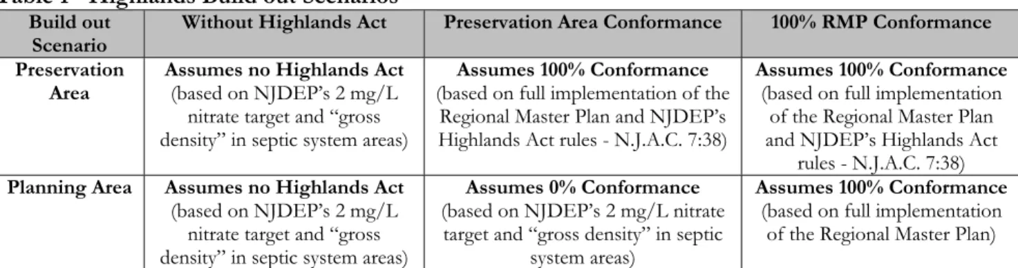
The Highlands Build out Model includes multiple scenarios to reflect the various possible development patterns in the Highlands Region. The nature of the Highlands Act itself requires that multiple build out scenarios be developed to account for the voluntary nature of conformance with the RMP in the Planning Area. In many ways, the use of multiple scenarios is far more informative than reliance on a single set of assumptions, as it helps to lay out the implications of different approaches. For these reasons, the Highlands Build out Model includes three primary scenarios including a development analysis assuming no Highlands Act, another assuming implementation of the Highlands Act only in the Preservation Area, and yet another assuming full implementation of the Act in both the Planning and Preservation Areas. Accordingly, these scenarios examine the build out implications for the entire Highlands Region and report results for the Preservation Area, the Planning Area, and the Highlands Region as a whole. These three primary build out scenarios are described more fully below and in Table 1.
The first scenario, Without Highlands Act, assumes that the Highlands Act has not been enacted. This scenario evaluated the estimated build out that would have occurred assuming development under municipal zoning and the New Jersey Department of Environmental Protection’s (NJDEP) Water Quality Management Plan rules (WQMP Rules) for sewer service septic system density. This scenario uses NJDEP’s 2 mg/L nitrate threshold from the WQMP Rules to estimate future septic system development. When the local zoning required a larger lot size (lower density) than the WQMP Rules permitted, the zoning lot size was applied in the build out analysis. The impacts of water availability and wastewater utility constraints are then identified.
The second scenario, Preservation Area Conformance, assumes full implementation of the Highlands Act for the 51 municipalities only for lands in the Preservation Area and assumes that the municipalities with lands in the Planning Area choose not to conform to the RMP. This scenario assumes that these Planning Area lands
3
would be built out under the permitted uses under existing zoning using NJDEP’s WQMP Rule nitrate thresholds where appropriate. Accordingly, the results for the Planning Area portion of this scenario are the same as the Without Highlands Act scenario. The impacts of water availability and wastewater utility constraints are then identified.
The third scenario, 100% RMP Conformance, assumes that all 88 Highlands municipalities fully implement the Highlands Act, the RMP, and NJDEP’s Highlands Act rules. Accordingly, this scenario represents a gross estimate of the full impacts of Plan Conformance throughout the Highlands Region without any additional growth based upon local discretion and available infrastructure capacity. Existing municipal zoning is used in this scenario and so it must be noted that through Plan Conformance zoning may be modified thereby shifting the results between residential and non residential development. The impacts of water availability and wastewater utility constraints are then identified.
Table 1 - Highlands Build out Scenarios* Build out
Scenario Without Highlands Act Preservation Area Conformance 100% RMP Conformance
Preservation
Area Assumes no Highlands Act(based on NJDEP’s 2 mg/L nitrate target and “gross density” in septic system areas)
Assumes 100% Conformance
(based on full implementation of the Regional Master Plan and NJDEP’s Highlands Act rules - N.J.A.C. 7:38)
Assumes 100% Conformance
(based on full implementation of the Regional Master Plan and NJDEP’s Highlands Act
rules - N.J.A.C. 7:38)
Planning Area Assumes no Highlands Act
(based on NJDEP’s 2 mg/L nitrate target and “gross density” in septic system areas)
Assumes 0% Conformance
(based on NJDEP’s 2 mg/L nitrate target and “gross density” in septic
system areas)
Assumes 100% Conformance
(based on full implementation of the Regional Master Plan) *Note the septic system analysis for these scenarios includes environmentally constrained lands in the determination of the regional septic yields and represents a gross density evaluation of buildable or developable lands based on the existing residential or non-residential zoning. Summary of the Highlands Build out Results
The results of the Highlands Build out Model include regional totals for the estimated additional development for each of the three primary scenarios. The results for the estimated development considering the available land for development are summarized in Table 2, which include the results of the Highlands Domestic Sewerage Facility (HDSF) wastewater capacity and HUC 14 subwatershed water availability constraints that may limit the land based development potential.
For land-based capacity alone, the scenarios show that full RMP conformance results in significantly less development potential than without the Highlands Act (a reduction of nearly 75% for residential development). For both wastewater utility capacity and water availability, it is not feasible to determine the relative residential and non-residential impacts of these constraints, and therefore the constraints are described as a percent of new demands. Municipalities would need to determine how they would apportion those constraints. Utility-based capacity constraints will reduce the final build out values for both scenarios, by 15% without the Highlands Act and by 11% with full RMP conformance. Whereas utility-based constraints are based on physical capacity and are directly applicable to both scenarios, water availability capacity is more complex. Without the Highlands Act, the RMP water availability limits would not exist. However, to help understand potential impacts, a comparison was made for both scenarios. Water availability under the RMP would also constrain the final build out values for both scenarios, by 27% in the scenario without the Highlands Act and by 2% under full RMP conformance.
4
Table 2 - Summary of Highlands Build out* – Land Based Capacity Constraints
Build Out Scenario New Dwelling
Units or Houses New Non-residential Development (million sq. ft.) Utility
Constraints Availability Water Constraints Existing Conditions 296,500 Without Highlands Act 47,600 108.1 3.5 MGD 15% of 6.0 MGD 27 % of Preservation Area Conformance 28,800 86.0 3.1 MGD 16% of 3.9 MGD 16% of 100% RMP Conformance 12,300 19.1 1.1 MGD 11% of 1.4 MGD 2% of *Rounded to nearest 100
It should be noted that the effects of utility and water availability constraints are not necessarily additive. Either water availability or utility capacity may be limiting, or both. Further, both utility-based capacity and resource-based capacity potentially can be modified through facility improvements or water supply management, which could change the results of this analysis.
It is important to recognize that the built out results are premised upon numerous assumptions and uncertainties given the regional nature of the analysis. This includes assumptions regarding the number of people per household, jobs per 1,000 square feet of non-residential development, water and wastewater demands per person, the extent of future land preservation, landowner decisions to withhold their land from the market, etc. Therefore, the results reported below all should be understood to represent a range of values rather than the precise number presented.
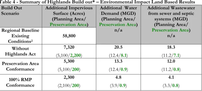
The land based build out results shown in Table 3 present the number of new houses, new residents, and new jobs. The land based build out results shown in Table 4 include three categories of environmental impacts including additional impervious surfaces, additional water demand, and additional wastewater demand. Tables 2, 3 and 4 also include the baseline conditions for houses, residents, acres of impervious surface, and existing jobs as a point of comparison for each of the build out scenarios. Each of the three scenarios represents the total increase from baseline conditions for the entire Highlands Region and additionally includes results for both the Planning Area and the Preservation Area.
Table 3 - Summary of Highlands Build out *– Demographic Land Based Results Build Out Scenario New Residents
(Planning Area/ Preservation Area) New Jobs (Planning Area/ Preservation Area) Regional Baseline Existing Conditions1 783,700 354,100
Without Highlands Act (93,500/174,800 81,300) (127,700/157,800 30,100) Preservation Area Conformance 104,300 (93,500/10,800) 127,700 (127,700/<100) 100% RMP Conformance 42,900 (32,100/10,800) 30,300 (30,300/<100) *Rounded to nearest 100
1 Existing Conditions are based upon data from the 2000 US Census for residents and dwelling units and 2005 New Jersey
5
Table 4 - Summary of Highlands Build out* – Environmental Impact Land Based Results Build Out
Scenario Additional Impervious Surface (Acres) (Planning Area/ Preservation Area) Additional Water Demand (MGD) (Planning Area/ Preservation Area) n/a Additional Wastewater from sewer and septic
systems (MGD) (Planning Area/ Preservation Area) n/a Regional Baseline Existing Conditions2 58,800 Without Highlands Act 7,320 (5,100/2,200) 20.5 (12.4/8.1) 18.3 (11.2/7.1) Preservation Area Conformance 5,300 (5,100/200) 13.3 (12.4/0.9) 12.0 (11.2/0.8) 100% RMP Conformance 2,300 (2,100/200) 4.8 (3.9/0.9) 4.1 (3.3/0.8) *Rounded to nearest 100
The results of the land based analysis for the 100% RMP Conformance scenario are presented in Figure 1 as a map of the Highlands Region. This figure depicts the estimated range of land based buildable lands that may occur in the Highlands Region with 100% RMP Conformance for each of the 88 municipalities. The extent of buildable lands varies for each municipality based on RMP policies and is influenced by the extent of existing development and preserved lands in a community as compared to undeveloped or underdeveloped lands. The evaluation of existing lands will be evaluated at the local level during Plan Conformance and will be updated as appropriate for the local build out analysis.
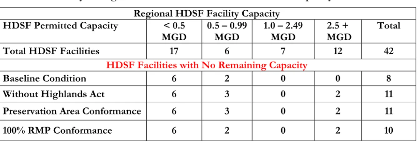
Table 5 includes a summary of the wastewater capacity implications for the Highlands Domestic Sewerage Facilities (HDSF) based on the Highlands Build out Model using the primary scenarios. There are 42 HDSF’s in the Highlands Region that were evaluated for whether available wastewater capacity can support the additional projected needs based on the land based build out. Of the 42 facilities, 8 currently have no permitted capacity available and these 8 facilities therefore are unable to serve additional capacity demands in the three primary build out scenarios. The land based build out demand that cannot be supported by these 8 facilities was evaluated based on equivalent dwelling units (EDU) as 300 gallons per day of wastewater. The number of EDU’s that cannot be supported range from 54 EDU Without the Highlands Act to 46 EDU with Preservation
Area Conformance and 38 EDU with the 100% RMP Conformance scenario. This indicates that the land based build
out projections are further limited in these sewer service areas, but that most of the facilities are small and therefore the impact on regional build out estimates is small.
The Without Highlands Act and the Preservation Area Conformance scenarios both indicate that three additional
HDSF’s would exceed available wastewater capacity. These facilities are Rockaway Valley Regional Sewer Authority, Warren County MUA – Belvidere, and Morristown. The Without Highlands Act land based build out results for these 3 HDSF facilities represents an inability to support nearly 1,700 EDU; that exceed available capacity and for the Preservation Area Conformance scenario the results are equivalent , indicating that most of the development potential is within the Planning Area. The 100% RMP Conformance scenario indicates that two additional HDSF’s would exceed available capacity, Rockaway Valley Regional Sewer Authority and Morristown representing an inability to support 370 EDU for these facilities. It appears that even with implementation of the RMP there is limited wastewater capacity in many some existing areas served by sewer.
6 Figure 1
7
Table 5 - Summary of Highlands Build out – HDSF Land Based Capacity Results Regional HDSF Facility Capacity
HDSF Permitted Capacity < 0.5
MGD 0.5 – 0.99 MGD 1.0 – 2.49 MGD MGD 2.5 + Total
Total HDSF Facilities 17 6 7 12 42
HDSF Facilities with No Remaining Capacity
Baseline Condition 6 2 0 0 8
Without Highlands Act 6 3 0 2 11
Preservation Area Conformance 6 3 0 2 11
100% RMP Conformance 6 2 0 2 10
The results of the water availability and wastewater analysis for the 100% RMP Conformance scenario were evaluated to see where potential opportunities exist in the Region for discretionary growth based on HUC 14 subwatersheds with water availability that also intersect with HDSF existing areas served with capacity; in both cases the available capacity is based on post-build out impacts. This positive–positive result for water and wastewater is shown in Figure 2. This figure depicts where the 121 HUC14 subwatersheds that would have at 3,000 gallons per day of consumptive water availability available water overlap with the existing area served for the 32 Highlands wastewater facilities (HDSF) that would have available remaining sewerage capacity are located within any of the 121 HUC14 subwatersheds that would have at least 3,000 gallons per day of consumptive water availability. The figure presents the potential opportunities for capacity planning that exist with implementation of RMP policies and will assist planning at the local level during Plan Conformance. Analysis of the Highlands Build out Results
The Highlands Build out Model raises several regionally significant implications and the key findings of the land based build out analysis are summarized below:
• The build out results for existing zoned lands indicate that without the Highlands Act 15% of the wastewater utility capacity demand (3.5 MGD) and 27% of the projected water availability (6.0 MGD) cannot be supported by the respective utilities and subwatersheds.
• Even with the development density requirements of the RMP being implemented, the build out projections indicate that 11% of wastewater capacity demand (1.1 MGD) and 2% of the projected water availability (1.4 MGD) cannot be supported by the respective utilities and subwatersheds in accordance with the RMP and therefore will further limit growth potential in some areas.
• Implementation of RMP policies represents approximately an additional 2,300 acres of impervious surface area in the Region as compared to 7,300 acres without the Highlands Act or a 68% reduction.
• Much of the undeveloped land zoned for commercial and industrial use is in environmentally constrained areas, outside of existing water and sewer service areas. Based on current population and infrastructure conditions, the development of many of these commercial and industrial lands is highly unlikely and does not reflect smart growth principles.
• If municipalities were to apply the discretionary growth policies of the RMP, the results indicate that in approved sewer service areas of the Planning Area Existing Community Zone, commercial lands could potentially represent 3 times the current jobs per acre density as compared to sprawl growth patterns that may occur without the Highlands Act. However, growth at that level would likely be subject to wastewater capacity and water availability constraints.
8 Figure 2
9
First, much of the projected growth under the existing municipal zoning is slated to occur in areas that are identified as suitable only for low density growth under the State Development and Redevelopment Plan (State Plan). The RMP and NJDEP’s Highlands Act rules (N.J.A.C. 7:38) result in build out levels for environmentally sensitive areas that are much more in keeping with the State Plan policies, and shift the ratio of development in non-sewered land versus sewered lands to a level that is more reliant on infrastructure for growth (i.e., Center-based development).
Second, the ratio of municipal zoning for undeveloped non-residential versus residential lands represents a highly unlikely and unsustainable regional ratio of jobs to housing (approximately 3.3:1), a ratio more typical of urban areas or inner suburbs with major job centers. The location of the non-residential zoning in environmentally sensitive areas that are not supported by water and wastewater infrastructure also represents regional concern such as increased traffic, water quality implications and regional utility capacity. All scenarios represent build out projections that exceed in varying degrees, water availability and utility capacity limitations. Through this analysis, it is clear that far more land is currently zoned for non-residential development than is sustainable. The re-evaluation of existing zoning to meet existing and future development will be a critical component of Plan Conformance. The land development practices of the RMP will bring the ratio to a more sustainable level, maximize the jobs to housing balance and transit options and minimize infrastructure investments and pollutant loadings.
Third, the projected wastewater demand under the Without the Highlands Act scenario is 3.5 million gallons per day (MGD), or approximately 23% of the available regional wastewater utility capacity of approximately 15.3 MGD.3 The 100% RMP Conformance scenario projects a wastewater demand of 1.1 MGD, which represents 7% of available capacity and allows a greater opportunity for the remaining capacity to be available for areas with failing septic systems, redevelopment, Transfer of Development Rights (TDR) receiving zones and cluster development that is adjacent to infrastructure, if sufficient water supply and net water availability exist in those areas.
While the creation of new sewer capacity may be feasible in some situations, the Highlands rivers are not large, many existing sewage treatment plants already use sophisticated treatment processes, and the costs of further upgrading Highlands facilities may be cost prohibitive. The 100% RMP Conformance scenario maximizes infrastructure investments by increasing the land use intensity within the existing sewer areas to support Center based development, enhanced transit, and community life opportunities. The model predicted that the development footprint based on the additional impervious surface acres that would be required for development is reduced from approximately 7,300 acres in the Without Highlands Act scenario to approximately 2,300 acres or by 68% in the 100% RMP Conformance scenario. Given the limitations of the model, “impervious surface” for this analysis represents only paved and built surfaces (or “hardscape”), rather than the Highlands Act definition which is more inclusive of surfaces that reduce infiltration but are not pavement or buildings. Lastly, the projected water demand in all scenarios exceeds net or conditional water availability in a number of HUC14 subwatersheds in the Highlands Region, and therefore water availability will be a constraint on achieving full build out. However, it should be noted that the Highlands Build out Model assumes that all of the projected development will be met by the watershed within which the development occurs and that there are no transfers of water, and it assumes no changes to net or conditional water availability through the implementation of Water Use and Conservation Management Plans. Therefore, the constraints indicated by the model are a “worst case” scenario that may be modified through further efforts. The water availability analysis for the Highlands Region based on the build out model does not include public community water supply infrastructure and a water tracking program.
The 100% RMP Conformance scenario land based build out results indicates the least number of subwatersheds
(5) with insufficient net or conditional water availability, as compared to the Preservation Area Conformance
scenario with approximately 7 times the number of subwatersheds with insufficient net or conditional water availability (34). The Without Highlands Act scenario indicates 71 subwatersheds with insufficient net or
3 The 42 HDSF’s have a total permitted capacity in the Highlands Region of approximately 122 MGD; 15.3 MGD is roughly
10
conditional water availability. With 100% RMP Conformance there are 121 subwatersheds that have at least 3,000 gallons per day of consumptive water availability remaining after build out, and therefore represent potential discretionary growth opportunities that will be further evaluated during Plan Conformance.
The RMP requires that net water availability not be exceeded (which would create a new deficit), that conditional water availability may be used only where 125% mitigation of the new uses is provided or guaranteed, and that subwatersheds with existing deficits must have Water Use and Conservation Management Plans to reduce or eliminate those deficits. Therefore, the land based development in such subwatersheds may only reach full build out if municipalities demonstrate through the water plans that the conditions for water availability have been met. This build out analysis should be considered an initial indicator of water availability constraints, and requires further refinement through a separate water tracking model because it does not consider the existing potable water supply infrastructure, the transfer of water and the ability to track water use through the Highlands Region and beyond.
In addition to the three build out scenarios, an evaluation of the land based ability of existing municipal zoning based on a local desire to grow in accordance with the RMP in the NJDEP approved sewer service areas of the Planning Area Existing Community Zone was performed. This evaluation in the Planning Area estimated build out using the RMP policies for utility infrastructure at 2 dwelling units per acre and a target floor area ratio of 0.84. The results for the land based build out indicate approximately 4,200 dwelling units and 111,000 jobs on only an additional 1,400 impervious surface acres region-wide. This represents 3 times the current jobs per acre density as compared to “without the Highlands Act” growth patterns if smart growth center based development practices are implemented for discretionary growth as required by the RMP, provided water availability and wastewater capacity needs are met. However, evidence from the 100% RMP Conformance
scenario indicate that water availability and wastewater utility capacity will be limiting in some areas.
These results show how center based development results in less impervious cover than the trend of “sprawl”. However, these additional houses and jobs come with water availability and wastewater capacity limitations. Therefore, at the local level it will be critical to align zoning and capacity planning through the application of the RMP policies in order to maximize infrastructure served areas.
Conclusions
The Highlands Build out Model evaluated the complete build out of available lands in the Highlands Region in order to examine the implications of the Highlands Regional Master Plan. The model also examines the extent to which existing wastewater facilities and subwatershed-based water availability are sufficient to accommodate the land based build out results. The model does not project when the full build out of available lands may occur, and therefore is fundamentally different from COAH model, which identifies developable lands and projects household and employment growth through the year 2018. Therefore this model cannot be used as a direct comparison to the COAH growth projections for 2018, as this model is based on full build out rather than a specific date, and the COAH model does not include considerations of water availability and wastewater facility capacity.
The Highlands Regional Build out Model is a planning tool that should be used to test growth scenarios and evaluate the potential environmental and social impacts that may occur. This land based build out analysis is based on existing municipal zoning (2005) and the resulting density of that residential and non-residential zoning varies with each of the build out model assumptions. Build out models are not predictions but projections, and therefore have their primary utility in planning for growth, preservation, environmental protection and various public service and infrastructure needs.
The reported results represent what may occur in the region if existing zoning designations continue to influence future development patterns. That being said, the build out indicates that the nature of existing zoning, even when the RMP policies are in place, may not be achievable due to water availability and wastewater limitations. Some zoning may be unachievable due to regional market conditions, as well. As always, site-specific impacts of development proposals will be addressed at a site plan level, rather than through a regional model, as will the relationship of the build out projections to utility capacity conditions.
11
The Highlands Build out Model will serve to support Plan Conformance and state, county and local capacity planning. It will be through Plan Conformance that the refinement of the build out model will take place. Municipalities working in partnership with the Council will have the opportunity to fine tune the initial regional scale build out model with local conditions and knowledge.
Additional topics that will be explored through the build out analysis in Plan Conformance include resource protection measures, development and redevelopment opportunities, clustering, jobs-housing balance, circulation plans, agricultural lands, land preservation, community facility plans, TDR opportunities, affordable housing obligations, and economic plans.
It is envisioned that the Highlands Build out model will serve to support Plan Conformance, the SDRP Plan Endorsement process, the NJDEP Water Quality Management Planning Rules, North Jersey Transportation Planning Authority (NJTPA) transportation capacity analysis and (with consideration of the 2018 target date) an evaluation of the Council on Affordable Housing (COAH) growth share plans.
PURPOSE
The overall purpose of defining the build out scenario assumptions was to evaluate the different impacts that may result in the Highlands Region at full build out of lands. The build out impact analysis focuses on the relationship between land development potential and the resultant people, jobs, school children, impervious surface, drinking water demand and wastewater generation when various regulatory and development policies are applied. The build out analysis serves as a planning tool to assist municipalities, counties and stakeholders to better understand the implications of existing zoning, as related to compliance with the Highlands Act in the Preservation Area and with or without compliance with the RMP in the Planning Area. Further, in all scenarios, an assumption was applied that no further land is preserved for agriculture, natural resources or recreational purposes, in order to provide estimates of maximum build out potential and also because it is not feasible to predict which parcels might be acquired over an extended period. Therefore, all scenarios will tend to over-estimate development at build out.
The initial regional build out analysis is not intended to depict real-time “on the ground” conditions in municipalities; that requires local knowledge and factual “on the ground” conditions that are not reflected in the regional data analysis. The importance of local knowledge has been recognized by the Council regarding the Plan Conformance process and the RMP Update process. The information provided in this technical report serves as the framework for working with municipalities during the Plan Conformance process in order to develop the Municipal Conformance Build out. The municipal build out will support future planning in the municipality as well as the Highlands Region and may be used in State agency reviews such as Council on Affordable Housing (COAH), Department of Environmental Protection (NJDEP), Department of Transportation (NJDOT) and others.
DATA AND METHODS
The New Jersey Highlands Council used geospatial and other data in combination with computer-based models to develop maximum residential and non-residential or commercial numeric build out estimates, and related physical, economic and environmental impacts of such development on the Region. (Refer to Appendices A-1 through A-4 for additional details regarding the municipal level impact analysis of the Highlands build out scenarios). The Highlands Council staff, working in partnership with its constituent municipalities, consultants and other state and local resources, compiled the following geospatial and other data that were used in the build out land use scenarios (Refer to Appendix B for supporting technical data, spatial date information/processing details and technical documents):
• Geospatially corrected Highlands Region and municipal boundary lines were used to refine and increase the accuracy of municipal build out and impact results.
• Municipal zoning information as of November 2005 was collected and evaluated for all 88 municipalities, including the designated use (residential, commercial, institutional, etc.) and associated residential and non-residential densities. The Highlands Council developed a zoning look-up table
12
representing the existing municipal zoning for all 88 municipalities, including density (dwelling unit (DU)/acre or Floor Area Ratio (FAR) value as stated in the zoning/land use ordinance. A build out default FAR value of 0.20 was applied when a non-residential FAR value was not prescribed in the Zoning/land use ordinance. A summary of Highlands Composite Zones by municipality is presented in Appendix B.
• All scenarios excluded lands considered to be constrained and not available for development due to conservation, preservation, regulatory protection or environmental sensitivity. The analysis excludes lands in the public domain or deed restricted such as parks, open space and preserved farmlands. The nature of the environmental regulations for the build out analysis with and without the Highlands Act varied accordingly, as well as the use of environmentally constrained lands in sewer and non-sewer areas.
• Boundary lines of all existing and approved NJDEP permitted sewer service areas greater than 20,000 gallons per day that are located within the Highlands Region were identified as Highlands Domestic Sewerage Facilities (HDSF). The HDSF sewer service area was used in the Without Highlands Act scenarios. For the Preservation Area Conformance scenario and the 100% RMP Conformance scenarios, the Preservation Area sewer service area was reduced to existing areas served (EAS) by wastewater infrastructure in accordance with the Highlands Act. The 100% RMP Conformance scenario in the Planning Area for Land Use Capability Map (LUCM) Protection and Conservation Zones and Existing Community Zone was also evaluated at the existing area served boundary.
• The additional analysis for the 100% RMP Conformance scenario with Discretionary Growth in the Planning Area for the LUCM Existing Community Zone (ECZ) only was evaluated at the NJDEP-approved sewer service area, to support the evaluation of whether available capacity exists to serve development beyond the existing area served. The ECZ Environmental Constrained Sub-zone was evaluated at septic system density standards. The impacts of water availability and wastewater utility constraints are then identified.
• An additional evaluation for potential redevelopment opportunities in the Planning and Preservation Areas was performed. For 100% RMP Conformance the 2007 MOD IV Non-Residential Property Class codes were evaluated as developed lands that may potentially be subject to redevelopment or intensified land use in the future. The impacts of water availability and wastewater utility constraints are then identified.
• The three primary scenarios for the Regional Build out Analysis are presented in Appendix B as flow charts that describe the geospatial data relationships and processing protocols. The appendix information presents flowcharts for the Without Highlands Act and the 100% RMP Conformance scenarios,
the Preservation Area Conformance scenario is a combination of those flow charts. The Preservation Area
portion is the same as the 100% RMP Conformance process and the Planning Area portion is the same as the Without Highlands Act process.
13
The following graphic depicts how the three primary build out scenarios relate to each other:
1. Without Highlands Act
Highlands Build out Scenarios
2. Preservation Area Conformance 3. 100% RMP Conformance Scenario Conformance to RMP &
Implement NJDEP Highlands Act Rules
(7:38)
Conformance to RMP &
Implement NJDEP Highlands Act Rules
(7:38) No Conformance to RMP,
No NJDEP Highlands Act Rules (7:38)
&
Implement NJDEP (7:15) Septic System 2mg/l Nitrate
Target
No Conformance to RMP &
Implement NJDEP (7:15) Septic System 2mg/l Nitrate
Target
No Conformance to RMP &
Implement NJDEP (7:15) Septic System 2mg/l Nitrate
Target
Conformance to RMP
With Highlands Act Without Highlands Act
MODEL ANALYSES
The Highlands Council used computer-based models to estimate the maximum number of dwelling units and amount of non-residential or commercial floor area space that might be created in a full build out of available land under each scenario. The available lands or developable areas in the model exclude environmentally constrained lands, developed lands, preserved lands, public lands, roads and utilities. The build out is a numeric analysis that assumes some portion of the available land would be set aside for roads, right of ways, and other public uses generally associated with land development in the Region. This set aside of lands for this purpose is referred to as the “Efficiency Factor” for development. (Refer to Appendix B for the Highlands Efficiency Factor information).
Using impact factors, the build out results for dwelling units and square feet of non-residential space were then converted into population and employment projections, and further into estimates of school-age children and then into impacts associated with growth such as water demand, wastewater generation, and impervious surface area. (Refer to Appendix B for the Highlands Build Out Impact Factors). The sources for evaluating impacts for the Highlands build out analysis were the same for all scenarios.
MODEL QUALITY ASSURANCE AND CONTROLS METHODS
In order to test the quality of the data and build out model assumptions, the following information were verified, checked for accuracy, and documented by the project team:
1. Base technical data and documents;
2. Build out methodology and assumptions; and
3. Project outputs, including build out, additional analysis and related impacts for all scenarios.
Quality Assurance was performed strategically throughout the analysis. Base data layers were individually verified as they were developed. Base data layers were checked for attribute accuracy, logistical consistency, completeness and positional accuracy as described in appropriate base data layer metadata information.
Methodology and assumptions were tested and outputs were analyzed based on known existing conditions, case studies or industry standards.
14
Quality reviews were performed by an individual other than the data developer or modeler and were supported by the team at the National Center for Neighborhood and Brownfield Redevelopment (NCNBR), Rutgers University working under contract with the Highlands Council.
Quality Assurance was performed on the build out developable/buildable Land for 100% RMP Conformance Analysis, as a test due to the fact that the development of this layer relies in part to Local Tax Assessment Data commonly known as (MOD IV) dated 2007. The MOD IV database is used for tax collection purposes and it the only known data source which attributes block and lot location with property classes across the Highlands Region. In some cases MOD IV data represent multiple property classes to the same block and lot, representing a many to one relationship. The Highlands Parcel Base Layer represents each block and lot as a unique record occupying a unique area, or a one to one relationship. Therefore a relationship must be made between the Highlands Parcel Base data spatial file to the MOD IV data and the records with a many to one relationship. The result is that the Highlands Parcel Base data layer may have multiple property classes assigned. Note that the Open space and Preserved lands were excluded from the developable /buildable lands data layer.
Due to the complexity of the many to one relationship between the two data sources all areas greater than 5 acres in the build out developable/buildable land for 100% RMP Conformance Analysis were visually inspected with both 2002 and 2004 aerial photography using a heads up approach. Areas were checked at a maximum of 1:10,000 ft scale and flagged for existing development patterns.
In summary out of the approximately 124,200 acres of MOD IV Property Classes 1 (Vacant) and 3B (Qualified Farm), in the regional build out analysis 9,400 acres or 7.5% were flagged as having a potential visual development footprint such as a home on a large lot, commercial or industrial business, condominium common areas or Right-of-Ways within the parcel (i.e. Roads). Some areas that were flagged included but were not limited to the Morristown Airport landing/departure strips, condominium common areas, and municipal ball fields. These anomalies exist because the MOD IV Tax Assessment data lists these areas as Property Class 1 or “Vacant” lands for tax reporting purposes. While these areas may have been included in the developable/buildable land for Regional Build out analysis it must be emphasized that Highlands Composite Zoning and Build Out Impact Factors (refer to Appendix B for more details) are applied to the Buildable Land analysis as part of the build out model. Therefore, when the local zoning indicates a development density of “zero” such as for public and institutional lands or right of ways the build out reports no impacts for these lands. Some areas that were identified as Institutional Zones included portions of the Morristown Airport and road Right-of-Ways, these areas received a zero building density as prescribed by the Highlands Composite Zoning.
This represents a 92.5% data quality review performance for the vacant and undeveloped lands in the regional build out analysis. Nearly 75% of the 9,400 flagged acres were zoned for one dwelling unit per acre or less. Nearly 8% of the flagged areas were zoned for public or institutional lands and assigned a development density of zero in the regional build out analysis. The RMP Update Program and the Municipal Build out Analysis have been designed by the Highlands Council to address the ability to ground truth the regional results at the local level. A Quality Assurance (QA) report for this analysis is provided in Appendix B.
CURRENT LAND CHARACTERISTICS
The Highlands Region is composed of 88 municipalities encompassing a total land area of approximately 859,358 acres. The Highlands Water Protection and Planning Act designated approximately 415,000 acres of land with exceptional natural resource value as the Highlands Preservation Area. All of the land in the Highlands Region that is not in the Preservation Area lies within the Highlands Planning Area. Approximately 7,180 acres of existing areas served by sewer are located in the Preservation Area representing less than 2% of the land area. Approximately 78,488 acres of existing areas served by sewer are located in the Planning Area representing 18% of the land area. The full New Jersey Department of Environmental Protection (NJDEP)-approved sewer service area in the Planning Area is 160,083 acres representing existing and planned service areas, and is approximately 36% of the Planning Area.
15 UNDEVELOPED LAND
Two types of data were used to define undeveloped lands, 2002 NJDEP LU/LC (land use /land cover) and 2007 MOD-IV. Land Use/Land Cover is a data layer created by the NJDEP that captures the state of land use and natural land cover as of March 2002 in a digital Geographical Information Systems (GIS) file. This data set classifies lands at a 1 acre minimum and was used to identify those land areas (not parcels) deemed to be already developed in the Highlands Region. (Refer to Appendix B for the summary of NJDEP Land Use/Land Cover Codes that were used in the analysis).
MOD-IV data, which stands for “modernization of the 4 line system,” contains uniform property tax information, as required by the Constitution of the State of New Jersey, the New Jersey Statutes, and the rules promulgated by the New Jersey Division of Taxation. This data set is parcel-based which means it has a different scale and focus than LU/LC data, and is generally more current than the 2002 NJDEP LU/LC data. MOD-IV data was used to identify undeveloped land parcels based on property class code 1 (Vacant) and code 3B (Farm Qualified) and for the evaluation of oversized lots in the septic yield analysis. (Refer to Appendix B for information on MOD IV data).
Although the MOD IV data set is parcel based and at a different scale than NJDEP LU/LC data, it is subject to the reporting discrepancies of 88 municipalities versus a single data set from the NJDEP. Further, it cannot be used to identify environmental constraints or situations where only a part of a larger parcel was developed, which required the use of the LU/LC data in combination with the MOD IV data. The MOD IV data may be appropriate for a regional analysis but due to data anomalies it is not appropriate for a local build out unless it is approved at the local level as an appropriate data source. Regardless of the scale of the data, the year of the data or the nature of the data collection and reporting, the data used in the build out model analysis are subject to change due to current “on the ground” conditions. The model assumptions and the data use protocols ensure consistency in data reporting at a regional scale and for an evaluation of a selected point in time and are not appropriate for a local build out.
PUBLIC AND PRESERVED LAND
A large portion of the undeveloped lands are public lands, such as roads, right-of-ways, water (lakes, rivers and streams), dedicated federal, state or local open space areas (parks, wildlife refuges, public golf courses), or are preserved farms that are privately owned but with public deed restrictions. Additional lands have been purchased by non-profit organizations and private individuals for the purpose of preserving critical animal and plant habitat areas, scenic vistas, and lands with important historic or cultural values. These lands represent 263,906 acres in the Highlands Region as of early 2008. All of these lands were subtracted from the undeveloped lands identified for each of the build out models, as they are not available for future development. (Refer to Appendix B for technical details of the Public Lands information).
ENVIRONMENTALLY CONSTRAINED LAND
Environmentally constrained lands, as defined by State regulations or policies were deemed to not be available for development in the sewer service areas and were included in the septic yield analysis. These lands were identified using the NJDEP 2002 LU/LC data and other related spatial information developed for or by the Highlands Council, and included wetlands, flood plains, riparian buffers along all streams, transition buffers around all wetlands, and steep slopes. Overall, these environmentally constrained lands represent 505,051 acres in the Highlands Region or approximately 59% of the Highlands Region. These environmentally constrained lands were expanded to include other important environmentally sensitive features defined in the Highlands Act and RMP. The environmentally constrained lands in accordance with the Highlands Act and the RMP represent 711,624 acres or approximately 83% of the Highlands Region. It should be noted that for the RMP septic system yield analysis the septic system lot size serves as the “limiting factor” for addressing environmentally constrained lands at the regional scale therefore, it is a “gross density” analysis. The RMP
16
existing areas served and sewer service area expansion analysis excludes the Environmental Constrained Sub-zone lands from the utility service area and evaluates those lands based on septic system standards.
EXISTING REGIONAL ZONING
The existing zoning for the Region indicates that approximately 14 percent of the lands in the Region are currently zoned for non-residential uses, 85% are zoned for residential use and the balance (1 percent) is mixed use. This land use mix is similar to the current 87 percent residential and 13 percent non-residential split among existing developed lands in the Highlands Region. About 60 percent of the non-residentially zoned acres are located outside of existing sewer service areas, and 74 percent are located in the three State Planning Areas that have been classified as areas for limited growth and conservation. (Refer to Appendix B for the existing zoning and Highlands Composite Zoning information).
The significant potential for growth in environmentally sensitive areas, as provided under current municipal zoning, is one of the reasons the Highlands Act was adopted by the State Legislature. The Act gave permitting and regulatory responsibility to the NJDEP for the Preservation Area and required the Highlands Council to develop a comprehensive Regional Master Plan encompassing both the Preservation Area and the Planning Area. The RMP is intended to achieve a regional approach to land use planning and a coordinated method for protecting the Region’s important natural resources.
BUILD OUT MODEL ASSUMPTIONS
The following is a summary of the build out model assumptions for environmental regulations and policy constraints, developable and buildable lands and land use and density assignments. Each of the detailed build out scenario assumptions is presented in Appendices A-1 through A-4. The detailed model protocols and data layers with the relevant assumptions for these primary build out scenarios is presented in Appendix B.
RULES – ENVIRONMENTAL REGULATORY AND POLICY CONSTRAINTS:
In the Without Highlands Act scenario, environmentally constrained lands were considered not available for development due to statewide regulations regarding conservation, preservation, regulatory protection or environmental sensitivity. Lands that are considered to be constrained by regulation include wetlands, flood prone areas, and buffers established along wetlands, streams and other water bodies. Lands considered constrained by policy include steep slopes greater than 15 percent, which is based on common municipal practice rather than State regulations.
Table 6: Pre-Highlands Act Regulations - Environmental Constraints
Constraint Source
Slopes of >15% USGS 30 meter Digital Elevation Model data Flood Prone/Flood
Hazard Areas CRSSA file based on NJDEP flood prone areas and FEMA Q3 flood data.
Wetlands NJDEP 2002 LULC
Buffers established along Wetlands, Streams, and other Water Bodies in accordance with the NJDEP Flood Hazard Control Act rules (2007)
CRSSA file based on NJDEP stream spatial file with designated stream buffers of 50', 150' and 300'. Buffer Rules: C1 and all upstream within HUC = 300'. Other stream miles upstream of TP or TM and waters draining within 1 mile upstream or stream segments flowing through T&E habitat that are critically dependent and all upstream waters within 1 mile = 150'. All other water = 50'. In the RMP Conformance scenarios the environmental constrained subzone served as the surrogate for environmental constraints in a sewer service area at a regional scale. These lands were evaluated as septic system yield for the build out analysis and not sewer. The RMP resource protection policies will be evaluated and applied at the project or site level and are not appropriate for a regional gross density evaluation.
17 Rules – Developable and Buildable Lands
The model was designed to evaluate the RMP’s policies regarding environmental constraints, water availability, and wastewater utility capacity. For the determination of lands that are potentially available for development, the analysis is based on municipal zoning as of 2005 and the existing undeveloped or underdeveloped parcels of lands as of 2007, excluding any preserved open space and other preserved lands. The developable lands for the Highlands Region based on the build out model are approximately 230,000 acres representing 123,000 acres in the Planning Area and 106,000 in the Preservation Area.
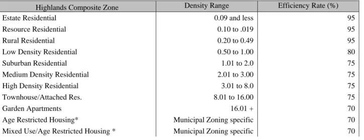
Each of the three primary scenarios represents the same potential 230,000 acres of developable buildable lands; however the buildable portion of these developable lands is influenced by the nature of the sewer service area lands and permissible densities or lot size changes for undeveloped and underdeveloped lands based on the scenario. The model assumes that all developable lands are, in fact, currently not developed and will not be either preserved or held out of the development market by private owners. It is important to note that the model does not incorporate any of the potential Highlands Act exemptions or potential TDR receiving zones. The model incorporates existing zoning for residential and non-residential land uses into the evaluation of build out impacts. Given the assumptions in the model, the reported results represent what may ultimately occur in the Highlands Region if existing zoning designations continue to influence future development patterns. (Refer to Appendices A-1 through A-3 for additional details on buildable lands for each scenario). The percentage of land retained for construction of the actual buildings is referred to as land use efficiency. Studies have shown that efficiency rates vary widely depending on actual land use. Rural type residential development generally consumes only a small portion of the net buildable land for common facilities, thus resulting in an efficiency of about 95%, whereas high-density residential areas often have large parking and roadway requirements and are able to only retain 75% of the available land for actual buildings. (Refer to Appendix B for details on the build out impact and efficiency factors).
RULES – LAND USE AND DENSITY ASSIGNMENT
The Highlands Council collected municipal zoning information from each of the 88 towns in the Region as of November 2005. The zoning information was compiled and evaluated for density and bulk standards and a spatial file of the zoning was developed. For purposes of estimating build out capacity the 1,304 individual municipal zones in the Highlands Region were collapsed into 16 similar composite zones, based on designated use and ranges of associated densities, and each was assigned a net buildable land efficiency rate. The build out impacts associated with the Highlands Composite Zones are presented in Appendix B for all residential and non-residential land uses. Note that the build out applied the reported municipal zoning density value and used the composite zone for assigning impacts. It is important to note that lands zoned for Institutional or Public lands were not evaluated for build out impacts.
Table 7: Highlands Composite Zone Density Range
Highlands Composite Zone Density Range Efficiency Rate (%)
Estate Residential 0.09 and less 95
Resource Residential 0.10 to .019 95
Rural Residential 0.20 to 0.49 95
Low Density Residential 0.50 to 1.00 80
Suburban Residential 1.01 to 2.0 75
Medium Density Residential 2.01 to 3.00 75
High Density Residential 3.01 to 8.0 75
Townhouse/Attached Res. 8.01 to 16.00 75
Garden Apartments 16.01 + 70
Age Restricted Housing* Municipal Zoning specific 70
18
Highlands Composite Zone Density Range Efficiency Rate (%)
Mixed Use* Municipal Zoning specific 70
Office/Commercial* Municipal Zoning specific 80
Retail* Municipal Zoning specific 80
Industrial* Municipal Zoning specific 80
Institutional/Public lands** See Note** n/a
*The reported density varies for these zones and was not able to be grouped into a range therefore it is specific to local Zoning density values and/or Highlands composite zone default values
** Represents a local Zoning designation that does not generate residential or non-residential development.
The evaluation of sewer lands for the build out applied the residential and non-residential impact factors based on existing zoning. The septic system yield analysis for the build out applied the resource residential impact factor for residential septic yield units. The septic system yield analysis for the build out applied an equivalent dwelling unit (EDU) value for non-residential zoned lands and the appropriate non-residential impact factor. The acres of residential zoned lands and non-residential zoned lands within the septic system yield were determined and the overall yield for that municipal subwatershed was assigned impacts based on the nature of the zoning. Lands that were zoned for institutional/Public lands were included in the septic system yield analysis but were not assigned impacts in the build out. Institutional/Public lands in sewer areas were also not assigned impacts in the build out. (Refer to Appendix B for details on the Septic System Yield Analysis and Equivalent Dwelling Unit evaluation).
BUILD OUT IMPACTS AND CAPACITY ANALYSIS
The following is a discussion of the land based build out results and the potential impact on population and household growth, employment opportunities, demand for potable water and wastewater treatment capacity, increases in impervious surface area, and the balance of jobs to housing. The discussion focuses on each build out scenario’s relationship of the land based analysis to infrastructure limitations and environmental resource impacts associated with the potential land use patterns modeled in the scenario.
HOUSEHOLDS, POPULATION AND SCHOOL CHILDREN
The Without Highlands Act scenario, estimates 47,600 new dwelling units representing approximately 26,100 additional dwelling units in the Planning Area and nearly 21,500 in the Preservation Area. The number of new jobs is 157,800 in the Without Highlands Act scenario due to the application of the NJDEP WMQP Rules regarding non-residential septic systems as equivalent dwelling unit values.
The Preservation Area Conformance scenario would estimate a total of 28,800 residential housing units through full build out of vacant land, of which 90 percent (26,100 units) would be in the Planning Area. The balance of 2,800 units would be estimated for vacant lands in the Preservation Area. This development capacity, though lower than the Without Highlands Act scenario, would translate into an increase in population of nearly 104,300 people across the Highlands Region. Although conformance to the RMP with regard to lands located in the Preservation Area will reduce residential growth and resulting increases in population and school age children in the most environmentally sensitive and critical resource areas of the Highlands, a large amount of growth would still be projected to occur on lands intended for limited growth and conservation in the Planning Area. Much greater progress in guiding and constraining the Region’s growth to where supporting infrastructure and other resources already exist would be achieved with full conformance to the RMP in both the Preservation and Planning Areas. Under the 100% RMP Conformance model scenario a total of 12,300 residential units would be constructed. This represents a 16,500 residential unit or 57% reduction versus the Preservation Area Conformance scenario and is related entirely to changes in the Planning Area.
Thus with 100% RMP Conformance, a total of about 9,500 housing units would be built in the Planning Area and 2,800 units would be built in the Preservation Area. The application of the RMP septic system standards as compared to the NJDEP WQMP Rules reduces the overall Planning Area dwelling units by approximately 16,600. This represents approximately a 61,400 reduction in projected population growth at build out versus
19
that associated with the Preservation Area Conformance scenario. The primary differences in this build out scenario are related to reductions in housing density outside of existing sewer service areas, based on RMP policies and projected growth that is more heavily focused within Existing Areas Served by wastewater.
EMPLOYMENT OPPORTUNITIES
The Without Highlands Act scenario indicates that a total of about 108.1 million square feet or 157,800 industrial, commercial and retail jobs could be created through full build out of available vacant land in the Highlands Region. It is worth noting for comparison purposes that in all of Morris County the total office space inventory as of 2007 was approximately 30 million square feet and the Northern New Jersey region included 120 million square feet with a 20.5% and 14.8% vacancy rate, respectively (includes all office buildings 10,000 square feet or greater; Sitar-Rutgers Report, February 2008, Volume 11, Number 1). The Parsippany submarket reported the largest two office leases in 2007 for the Northern and Central market, representing 333,000 square feet driven by pharmaceutical and communication companies due to highway access and skilled workforce components (Sitar, February 2008)). During the 2004 to 2006 timeframe the state gained approximately 23,000 private sector jobs and that dropped to just 3,700 jobs for 2007 therefore the “if you zone for the ratable it will come” mentality is limited in the context of state and national employment growth conditions (Sitar, May 2008). This projected employment opportunity based on zoning does not represent a realistic opportunity in light of current and historic land development practices.
The New Jersey Department of Labor and Workforce Development (NJDOL) reported 354,115 jobs in the Highlands Region for 2005.Of this, about 73 percent would be constructed in the State Planning Areas intended to be used for limited growth and conservation. The Without Highlands Act scenario estimates 157,800 jobs in the Region and the projected amount of non-residential development in nearly 108.1 million square feet. The Preservation Area Conformance scenario estimates low levels of non-residential development in the Preservation Area, and development within the Planning Area is based on no Conformance to the RMP but the NJDEP WQMP Rules. This would result in a build out of 86.0 million square feet of space in the Highlands Region versus the 108.1 million square feet Without Highlands Act scenario, with the entire reduction of 22.1 million square feet occurring in the Preservation Area. This in turn would translate into about 30,100 fewer jobs than the Without Highlands Act scenario.
As with the residential housing projections, conformance to the RMP with regard to lands located in the Preservation Area will reduce industrial, commercial and retail development in the most environmentally sensitive and critical resource areas of the Highlands. However, a large amount of growth would occur at build out on lands intended for limited growth and conservation in the Planning Area and in areas lacking sufficient infrastructure to support such growth. Under the 100% RMP Conformance model scenario a total of only 19.1 million square feet of non-residential floor space would be projected at build out. This represents a 66.9 million square foot reduction versus the Preservation Area Conformance scenario, related entirely to the Planning Area.
Overall, the 100% RMP Conformance scenario would project almost an 88% reduction in non-residential space at build out than what has been projected for the Preservation Area Conformance scenario. This development level would also project about 97,400 fewer jobs than the Preservation Area Conformance scenario and 127,500 fewer jobs than the Without Highlands Act scenario. However, as discussed previously the existing commercial and office development as related to the current municipal non-residential zoning for such development may not represent a realistic potential for jobs growth.
The 100% RMP Conformance Scenario with Discretionary Growth projects 141,500 jobs in the region located in the Planning Area. This scenario evaluates the Planning Area’s Existing Community Zone planned and approved sewer service area, outside of the Existing Area Served, as being developed at a target 0.84 FAR value, which requires at least a two-story building. This represents an increase of approximately 111,000 jobs from the 100% RMP Conformance scenario within existing developed areas along transportation and transit routes, as well as jobs that are close to housing, reducing vehicle miles traveled and air and water pollution levels. This smart growth development pattern is subject to water availability and wastewater capacity limitations but it does indicate that opportunities for discretionary growth in accordance with RMP policies