Review
Object Detection and Image Segmentation with
Deep Learning on Earth Observation Data:
A Review—Part II: Applications
Thorsten Hoeser1,* , Felix Bachofer1 and Claudia Kuenzer1,21 German Remote Sensing Data Center (DFD), German Aerospace Center (DLR), Münchner Straße 20, D-82234 Wessling, Germany; [email protected] (F.B.); [email protected] (C.K.)
2 Department of Remote Sensing, Institute of Geography and Geology, University Würzburg, Am Huband, D-97074 Wuerzburg, Germany
* Correspondence: [email protected]; Tel.: +49-8153-28-3966
Received: 24 August 2020; Accepted: 16 September 2020; Published: 18 September 2020
Abstract:In Earth observation (EO), large-scale land-surface dynamics are traditionally analyzed by investigating aggregated classes. The increase in data with a very high spatial resolution enables investigations on a fine-grained feature level which can help us to better understand the dynamics of land surfaces by taking object dynamics into account. To extract fine-grained features and objects, the most popular deep-learning model for image analysis is commonly used: the convolutional neural network (CNN). In this review, we provide a comprehensive overview of the impact of deep learning on EO applications by reviewing 429 studies on image segmentation and object detection with CNNs. We extensively examine the spatial distribution of study sites, employed sensors, used datasets and CNN architectures, and give a thorough overview of applications in EO which used CNNs. Our main finding is that CNNs are in an advanced transition phase from computer vision to EO. Upon this, we argue that in the near future, investigations which analyze object dynamics with CNNs will have a significant impact on EO research. With a focus on EO applications in thisPart II, we complete the methodological review provided inPart I.
Keywords: artificial intelligence; AI; machine learning; deep learning; neural networks; convolutional neural networks; CNN; image segmentation; object detection; earth observation
1. Introduction
The availability of spatio-temporal Earth observation data has increased dramatically over recent decades. This data provides the needed information to understand and monitor land-surface dynamics on a large scale, for example: urban growth and the distribution of settlements [1], vegetation cover and its temporal dynamics [2], and water availability [3]. Traditionally such studies analyze aggregated classes: buildings and impervious surfaces are summarized as built-up areas, trees and grassland become regions with different vegetation intensities, and open water and shorelines are mapped as binary water masks. However, to investigate the intrinsic characteristics of land cover and land use classes, the spatio-temporal dynamics of the single entities which compose those classes must be taken into account. Doing so will allow us to better understand the livelihoods on our planet: is urban growth characterized by expansion or redensification? Which kind of buildings are newly built and how are existing buildings modified? Which specific species and plant communities are present in areas labeled as vegetated? How does human interaction with ecosystems specifically affect single maybe endangered species? Is a specific ship the cause for a specific oil spill?
The spatio-temporal patterns of single entities like vehicles for transportation, the accumulation of humans and goods or artificial infrastructures enables the description of space and how it is
used precisely. Therewith, answering urgent geoscientific research questions becomes possible and Earth observation as a tool can be more intensively used in everyday applications. Overall, in Earth observation, land surface dynamics could be better described asspecific thingswithingeneral classes.
One crucial requirement to identify objects in remote sensing images is the availability of spatio-temporal Earth observation data with a high to very high resolution. With the ongoing development of spaceborne missions and open archives, the trend in increasing data availability will continue in the near future. Nevertheless, due to the vast amount of data, processing techniques are required that are adaptive, account for spatio-temporal characteristics, fast in processing and can be automated while still competing with human performance or even outperforming them [4,5].
With the emergence of deep learning, a technique has been introduced which is able to meet these requirements [4]. During the ImageNet Large-Scale Visual Recognition Challenge (ILSVRC) in 2012, Krizhevsky et al. [6] proved the potential of convolutional neural networks (CNNs) by outperforming established methods [7]. The proposed CNN predicts only on learned features from training data instead of using handcrafted features designed by humans. Since 2012, the diversity of deep-learning models has been steadily increasing. Today, they are state-of-the-art techniques for image segmentation and object detection which can extract fine-grained information and objects from imagery data. Furthermore, the capabilities of artificial intelligence and deep learning were found to be exceptionally relevant to current ecological challenges as well as their interactions with economy and society, as formulated in the sustainable development goals [8].
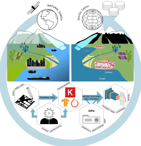
These properties make deep learning the most promising tool for handling complex, large-scale environmental information, with CNNs especially capable of analyzing imagery data. Considering the leading role of deep learning in image recognition, image segmentation and object detection, these methods can automatically archive and classify Earth observation data on a scene, instance and pixel level. Hence, deep learning is ideally suited for Earth observation research in order to create inventories of objects towards a digital twin earth [9] as illustrated in Figure1, in order to better analyze object dynamics and their impact on our planet.
With these features of deep learning in mind, the question arises how, and for which data types and applications, deep learning has been used in Earth observation research. Previous reviews about deep learning on Earth observation discussed the potential of deep learning [4,10–14] or the usage of different model types [10–14] in a broad perspective. More recent reviews also started discussing deep learning from a data type perspective, like for hyperspectral [15–17] or radar [18] data as well as from an application perspective as in [19] for change detection. In most of these reviews, the CNN deep-learning model type received the most attention and can today be seen as an established deep-learning model in Earth observation applications. Due to the importance of the CNN, not just in the field of Earth observation but also in computer vision [20], this review focuses specifically on CNNs for object detection and image segmentation applied to Earth observation data. Furthermore, to provide a detailed review of the most common data and architectures, the review focuses on the most used sensors types, like optical, multispectral and radar. To our knowledge, this review is the first in Earth observation with a detailed perspective on a specific deep-learning model type, allowing a comprehensive discussions which will help to understand recent developments and current applications.
The predecessor of this review series,Part I: Evolution and Recent Trends[21] hereafter referred to as “Part I”, is dedicated to thoroughly reviewing the history of CNNs in the field of computer vision since its emergence in 2012 until late 2019. This review,Part II: Applications, describes the transition from CNNs developed in the field of computer vision to their application in the field of Earth observation research in depth by reviewing 429 papers published in Earth observation journals. In detail, the scope of this review is to give an overview of the:
• spatial distribution of research teams and study sites,
• most employed platforms and sensor types,
• application domains and specific applications, where deep learning for object detection and image segmentation was used,
• most employed CNN architectures and their adaptations to remote sensing data applied for object detection and image segmentation,
• deep-learning frameworks which are commonly used by Earth observation researchers.
Figure 1.Conceptual overview of the derivation of digital entities from remotely sensed data using deep-learning techniques. The upper left part describes the natural earth with different land surfaces, objects and their interactions. The upper right part shows the digitized version of the natural earth with a focus on extracting specific entities. The lower part describes a deep-learning workflow: the creation of training data; model building and training; and application of the trained model to produce large-scale inventories of objects and their dynamics on Earth’s surface.
Continuing fromPart I[21], where the theoretical background on CNNs was provided, this review further lowers the entry barriers for researchers who want to apply deep learning in Earth observation. This is done by presenting the above-mentioned attributes of CNNs in Earth observation research and pointing to the established methods in combination with data types and applications. This will help to find the best combination of data, models and frameworks to successfully implement
a deep-learning workflow as pictured in Figure1. Furthermore, we show new perspectives of deep-learning applications to Earth observation data by discussing recent developments.
2. Review Methodology
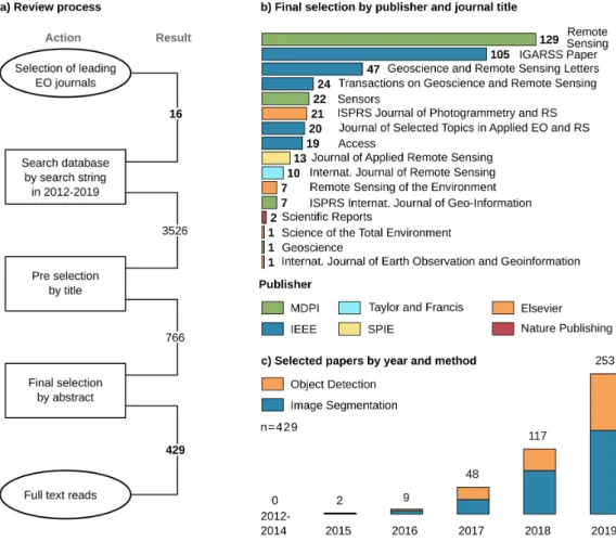
Figure2a describes the review process. The majority of reviewed sources come from 14 peer-reviewed journals with a focus on Earth observation by analyzing imagery data, see Figure2b. In addition, the IGARSS proceedings were included due to their combination of method development and application of deep learning from an Earth observation perspective. Finally, to picture the reach of Earth observation in a multidisciplinary context, Scientific Reports by Nature publishing was added, resulting in 16 journals, see Figure2b.
Figure 2.(a) Summary of the review process of 16 journals and 429 included papers. The search period for potential papers starts in 2012, due to the initial introduction of CNNs by Krizhevsky et al. [6] for image processing. (b) Overview of the included journals, publishers and number of papers per journal. (c) Temporal distribution of the 429 papers separated by task: object detection (168) and image segmentation (261).
A search string queried the journal databases:“deep learning” OR “convolutional neural network” OR “fully convolutional” OR “convolutional network”. With respect to Part I [21], we defined the work of Krizhevsky et al. [6] in 2012 as starting point for the emergence of CNNs in image analysis and included all articles until 2019 to maintain a whole year frequency. The resulting 3526 potential papers were then filtered by title, giving 766 candidates, and further screened by abstract. To focus on publications which mainly extract spatial features from imagery data, we included articles which used optical, LiDAR, multispectral, thermal or radar data in combination with a CNN as the deep-learning model. To specifically concentrate on image segmentation and object detection, we excluded all publications which investigate image recognition tasks, in EO often referred to as scene
recognition, where a single label is predicted for the entire image. Furthermore, to focus thematically, we concentrate on land-surface processes and therewith excluded publications which investigate atmosphere or atmosphere-land interaction applications. These criteria for in- and exclusion lead to a selection of studies which can be compared and discussed together since they follow similar approaches in CNN architectures and at the same time represent a wide thematical variety.
Finally, with 429 papers, the review represents the development of deep learning in Earth observation since 2012. Despite the searched period from 2012 until 2019, the onset of CNNs used for image segmentation and object detection in an Earth observation context took place in 2015 and increased to 253 papers in 2019, see Figure 2c. Since 2016 the group of papers concerning image segmentation is larger than the group using CNNs for object detection. The review was conducted based on the 429 selected papers by full-text reads while looking for attributes like the spatial distribution of author’s affiliations and study sites, researched applications as well as employed datasets, remote sensing sensors, CNN architectures and deep-learning frameworks. Therefore, the reported CNN architecture for each paper is the best performing architecture investigated, especially in ablation studies which compare multiple architectures. The complete table of all 429 papers reviewed with all determined attributes is provided in AppendixAin.csvformat. 3. Results of the Review
3.1. Spatial Distribution of Studies
The spatial distribution of first author’s affiliations depicted in Figure3clearly shows the largest share have Asian affiliations (68%), with 62% coming from China alone. Furthermore, European and American affiliations contribute with about 19% and 10% respectively. The high number of publications from Chinese affiliations can be explained by a high contribution of papers with a strong methodological background. Such papers have a focus on developing deep-learning algorithms for Earth observation data and mostly use well-established datasets for ablation studies.
Figure 3.Overview of first author affiliation grouped by countries and continents. The largest shares among the continents are: Asia (68%), Europe (20%) and America (11%); and the largest shares among the countries are: China (62%), USA, Germany and Netherlands (each 5%).
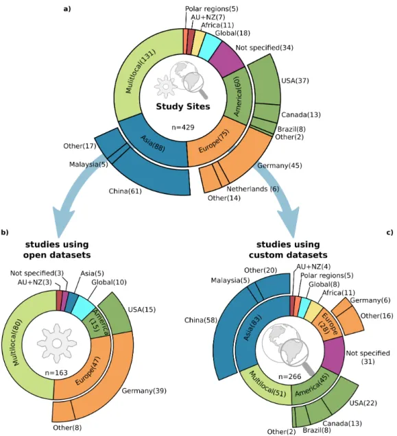
Further details become clear when looking at the distribution of study sites in Figure4. In Figure4a which shows study sites of all publications, the classMultilocalhas the biggest share and together with studies of classNot specified, they represent about 38% of all studies. It is characteristic that most of these studies took data from multiple locations or not-further defined places with a minor
focus on a geoscientific research question or a distinct study site. Rather, they focus on the technical implementation of CNNs on Earth observation data and proof-of-concept studies, which are an essential driver of the increasing usage of CNNs in Earth observation research. In this subgroup of studies without a specific located study site, the contribution from authors with a Chinese affiliation (84%) is by far the largest. The next two larger contributors are Germany and France with 2% each.
Figure 4.Overview of study site locations, whereMultilocalrefers to locations scattered over multiple continents commonly without a distinct spatial focus. (a) The study site locations for all 429 reviewed studies. (b) Study site locations of studies which used open datasets (38%), commonly focusing on method development. (c) Study site locations of studies which used custom datasets (62%) which investigate method development, and especially proof-of-concept studies as well as large-scale geoscientific research questions.
Furthermore, when splitting the study sites into two groups, as presented in Figure 4b,c, the substantial contribution of Chinese studies especially in publications with a methodological focus, becomes evident. The used datasets separate the two groups: the first group in (b) shows the studies, which are using established datasets. With this, the used datasets define the study sites, and the focus is on examining an algorithm for a specific task. The second group (c) shows studies which use a customized dataset and therefore the selected location is more meaningful for the underlying research question. Contributions from Chinese affiliations in the first group (b) are about 78%, higher than their
overall contribution (62%). As follows, contributions of Chinese affiliations in group (c) with custom study sites are still high (52%) but lower compared to the overall contribution.
The number of studies located in Germany is also noticeable when separating the study sites in the two groups mentioned above. In group (b) there are 39 studies, whereas the share drops to only 6 studies in group (c). This imbalance results from two well-established datasets, the ISPRS Potsdam and Vaihingen [22] datasets, commonly used for ablation studies of image segmentation algorithms. Interestingly, 54% of the 39 studies with a German location in group (b) are published by authors who are with Chinese affiliations, which further proves the Chinese contribution to method development in deep learning for Earth observation.
Furthermore, a closer look at Figure4c shows the still small number (3%) of studies with both a global perspective and customized datasets, or in other words deep learning applied to geoscientific research questions on a global scale. However, the study site distribution of customized datasets shows a more balanced picture, except for the African continent.
3.2. Platforms and Sensors
Traditionally, deep learning with CNNs was developed in computer vision for RGB image analysis where rich feature information is present due to a sufficient image resolution such as in the ImageNet [7], PASCAL VOC [23,24], MSCOCO [25] or Cityscape [26,27] datasets. Therefore, widely used CNN models are designed for three-channel input data and are often the starting point for investigations in other domains like Earth observation. This origin can be related to the most commonly investigated data types. Optical RGB images with a very high (<100 cm) and high (100 < 500 cm) spatial resolution are the most widely used imagery data in Earth observation with 56%, as depicted in Figure5a.
Figure 5.(a) Distribution of employed sensor types and their combinations with the largest shares for optical (56%), multispectral (26%) and radar (13%) sensor types. (b) Distribution of employed platforms and their combination with the largest shares for satellites (43%), aircraft (26%) and their combination (20%).
Studies which apply multispectral or radar data have shares of 26% and 13% respectively. However, especially in radar remote sensing, deep learning is gaining in popularity [18]. The number of publications which exploit radar data increased from 4% in 2017 to 15% in 2018 and 2019. This increase indicates the subsequent percolation of deep-learning methods in Earth observation. Sensors which provide a high spatial resolution are by far the most widely employed across all sensor types. Data with a spatial resolution <500 cm (VHR and high) are used in 79% of the publications and even when
increasing the spatial resolution to <100 cm (VHR) they still represent 43% of all studies and are therewith the largest group.
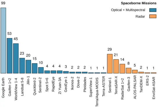
Figure5b shows that 43% of the studies used spaceborne platforms, whereas 36% solely rely on airborne platforms. The use of airborne platforms supports the above-given statement about the usage of data with a very high to high spatial resolution. Furthermore, it also supports the findings in Section3.1that most publications focus on small-scale, proof-of-concept and method development studies rather than large-scale applications. However, the 43% of publications which use spaceborne platforms should have the potential to investigate larger scales, beyond regional and national data acquisition projects. Still, the majority investigate local, single scenes or smaller clippings, scattered over multiple scenes, also focusing on proof of concept or method development. Therefore, the spatial resolution of the imagery data is mainly very high or high when looking at the spaceborne missions employed by the studies, see Figure6.
Figure 6.Overview of the most employed spaceborne missions in the 429 studies. Google Earth is also included due to its importance for receiving optical images with a high and very high spatial resolution, even when the underlying mission is not reconstructable. Overall, the overview shows the relevance of missions which focus on a high to very high spatial resolution and optical sensors.
A prominent number of studies use Google Earth as a data source. Even when the zoom level in Google Earth determines the platform and mission, the reported spatial resolution in such studies was between 50 and 200 cm, which indicates that a spaceborne optical sensor sensed the image. Hence, Google Earth appears among spaceborne optical missions, even when conveying every specific mission was not possible. Besides Google Earth, the reported spaceborne missions Gaofen 1 + 2 and WorldView 1–4 are the most established data sources, both known for their high spatial resolution. Similar to the study contributions, with the Gaofen missions, Chinese remote sensing missions are also prominent in the field of data acquisition. Frequently employed spaceborne radar missions such as TerraSAR-X, RadarSat 1 + 2 and Gaofen-3 also have a relatively high spatial resolution among radar sensors. The large number of 29 studies which use Sentinel-1 data can be related to 17 investigations that work on ship detection, which will be further discussed in Section3.4.1.
3.3. Datasets Used
Freely available datasets and their often-associated challenges play an essential role in the development of deep-learning methods. The impact of datasets like ImageNet [7], PASCAL VOC [23,24], MSCOCO [25] or Cityscape [26,27] are striking on the evolution of CNNs as discussed inPart I[21]. A similar impact can be seen in the field of Earth observation. Datasets which were present since early 2013 have widely affected the development of CNN architectures as well as the fields of application. Table1summarizes the most frequently used datasets within the 429 studies in this review.
When looking at the datasets for image segmentation, the strong relation to urban VHR feature extraction, building footprints and road extraction becomes evident. The already mentioned ISPRS Potsdam and Vaihingen datasets [22] are the most widely used. Together with the IEEE Zeebruges dataset [28], they are applicable in both urban VHR feature extraction and less frequently used for extracting building footprints. The Massachusetts buildings and roads datasets published by Mnih [29] are also commonly used in the settlement domain. Building footprint extraction is further enhanced by several SpaceNet challenges featuring building footprints [30–33] as well as by the WHU Building dataset [34]. Road segmentation was also a topic of several datasets and challenges like the DeepGlobe Roads challenge in 2018 [35] or two SpaceNet challenges [36,37] as well as the published dataset by Cheng et al. [38].
The most popular datasets for object detection are multi-class object detection datasets like NWPU VHR-10 [39], DOTA (Dataset for OD in Aerial Images) [40] or RSOD (Remote Sensing Object Detection) [41]. They provide bounding boxes for 10 to 15 classes, and in case of DOTA the bounding boxes are also available as rotated bounding boxes. Like ISPRS Potsdam and Vaihingen [22], those datasets are mainly used for method development and ablation studies. Nevertheless, since single classes can be extracted easily from such datasets, they are also frequently used for ship, car or aircraft detection, which are all classes that are commonly present in multi-class datasets. Other datasets focus solely on a single class, often related to the transportation sector. SSDD (SAR Ship Detection Dataset) [42] and OpenSARShip [43,44] both focus on ship detection from SAR imagery, whereas Munich 3K [45], VEDAI (Vehicle Detection in Aerial Imagery) [46], and busy parking lot are used for car detection. Busy parking lot is special in the way that it is an annotated high-resolution video [47]. Overall, open datasets and challenges have a significant influence on the topics investigated by researchers, which will be further discussed in the next Section3.4. However, 265 studies (62%) used custom datasets or combined custom datasets with the datasets mentioned above. In order to create custom datasets, labeling by hand is the most common and accurate but also labor-intensive way, whereas creating datasets from synthetic data is fast, generic and offers an inexpensive alternative as shown by Isikdogan et al. [48] and Kong et al. [49]. Since synthetic data is hard to create for multispectral and radar remote sensing, weakly supervised approaches [50–52] and studies that leverage OSM (Open Street Map) data [53–68] offer insights in how to use fuzzy data sources [69]. Thus, researchers are encouraged to use such approaches or small-scale hand-labeled datasets for proof-of-concept studies in order to build custom, large-scale, deep-learning datasets in the next step. When building deep-learning datasets, several properties should be considered, Long et al. [5] give a thorough discussion about the creation of benchmark datasets, to which we refer for further reading.
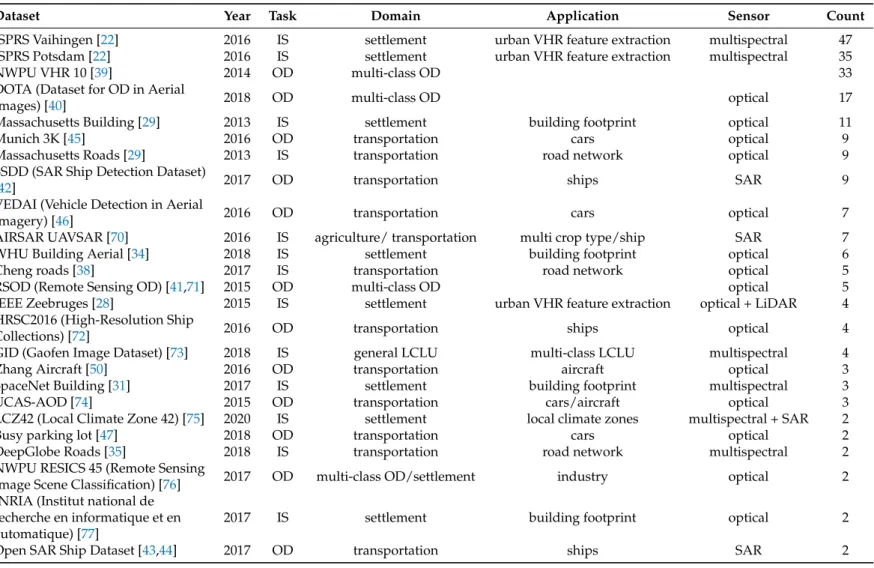
Table 1.Overview of used open datasets which were mentioned two times or more in the reviewed publications. The column,Taskdescribes the main usage of the datasets from a methodological perspective divided into the two groups: object detection (OD) and image segmentation (IS). The application domains settlement, transportation and multi-class object detection are the most prominent. Of specific applications the detection of ships, cars and multiple object classes as well as the extraction of building footprints, urban VHR features and road network extraction are the most investigated topics.
Dataset Year Task Domain Application Sensor Count
ISPRS Vaihingen [22] 2016 IS settlement urban VHR feature extraction multispectral 47
ISPRS Potsdam [22] 2016 IS settlement urban VHR feature extraction multispectral 35
NWPU VHR 10 [39] 2014 OD multi-class OD 33
DOTA (Dataset for OD in Aerial
Images) [40] 2018 OD multi-class OD optical 17
Massachusetts Building [29] 2013 IS settlement building footprint optical 11
Munich 3K [45] 2016 OD transportation cars optical 9
Massachusetts Roads [29] 2013 IS transportation road network optical 9
SSDD (SAR Ship Detection Dataset)
[42] 2017 OD transportation ships SAR 9
VEDAI (Vehicle Detection in Aerial
Imagery) [46] 2016 OD transportation cars optical 7
AIRSAR UAVSAR [70] 2016 IS agriculture/ transportation multi crop type/ship SAR 7
WHU Building Aerial [34] 2018 IS settlement building footprint optical 6
Cheng roads [38] 2017 IS transportation road network optical 5
RSOD (Remote Sensing OD) [41,71] 2015 OD multi-class OD optical 5
IEEE Zeebruges [28] 2015 IS settlement urban VHR feature extraction optical + LiDAR 4
HRSC2016 (High-Resolution Ship
Collections) [72] 2016 OD transportation ships optical 4
GID (Gaofen Image Dataset) [73] 2018 IS general LCLU multi-class LCLU multispectral 4
Zhang Aircraft [50] 2016 OD transportation aircraft optical 3
SpaceNet Building [31] 2017 IS settlement building footprint multispectral 3
UCAS-AOD [74] 2015 OD transportation cars/aircraft optical 3
LCZ42 (Local Climate Zone 42) [75] 2020 IS settlement local climate zones multispectral + SAR 2
Busy parking lot [47] 2018 OD transportation cars optical 2
DeepGlobe Roads [35] 2018 IS transportation road network multispectral 2
NWPU RESICS 45 (Remote Sensing
Image Scene Classification) [76] 2017 OD multi-class OD/settlement industry optical 2
INRIA (Institut national de recherche en informatique et en automatique) [77]
2017 IS settlement building footprint optical 2
3.4. Research Domains and Applications
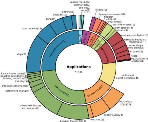
In Figure7, nine application domains are depicted to provide an overview of the diversity of applications of deep learning in Earth observation. Three categories, settlement, transportation and multi-class object detection, are directly connected to the previously mentioned datasets. Within these categories, the classes ships, road network and cars as well as building footprints and urban VHR feature extraction and the entire group multi-class object detection, represent 53% of all publications. Through this, the influence of open datasets become distinct and show the strong data-driven paradigm, which is necessary for method development and establishing CNNs as a common tool for the Earth observation community.
Figure 7.Detailed summary of all 429 investigated applications and their nine greater categories, called application domains. Transportation (27%), settlement(26%) and general land cover land use (LCLU) (13%) have the largest shares among the domains. Ship detection (12%), urban VHR feature extraction and building footprints (each 10%), as well as the entire group of multi-class object detection (11%), are the most investigated specific applications.
In this section, all nine application domains will be investigated thoroughly by mentioning both research topics for which CNN-based deep-learning models are already established and novel applications. In the following, the domains and single applications will be discussed by decreasing order of the number of publications, following Figure7.
3.4.1. Transportation
Of all reviewed publications, 27% investigate targets related to the transportation sector, such as the detection of ships, cars, aircraft or entire airports as well as the segmentation of road networks. Ship detection is one of the most studied Earth observation object detection problems, with many best practice examples on how to transfer deep-learning algorithms to the specific needs of remotely sensed data [57,78–110]. Hereby, the relatively more challenging inshore ship detection, compared to offshore
situations, draws the most interest. For better detection, studies are using land-sea masks derived by elevation models or coastlines from OSM to suppress false detection of ship-like structures on land [57]. Other studies process the land-sea mask jointly on the same image the ships are detected from, within one deep-learning model. This is done by combining an early land-sea binary segmentation before the ship detection step [86–89]. Another approach is to train on negative land samples, in order to teach the model that ships do not appear in such an environment [91,92]. In addition, Chen et al. [90] proposed a method, which produces specific ship aware attention masks before detection, which are then used to support more precise ship localization during the detection process.
Images with a very high resolution were especially used to detect ships in situations where they are lying very close together, like in harbors or near harbor berths. In order to separate multiple ships or disentangle ships and harbor structures, rotated bounding boxes were found to be very useful [79,93–105]. In contrast to horizontal bounding boxes, they allow a higher signal to noise ratio and hence, better detection performance [95]. Also, the overlap of nearby bounding boxes decreases, which prevents falsely suppressed bounding boxes of dense conglomerations of ships. Other approaches optimize the detection performance for densely packed ships and near land anchoring situations by incorporating nearby spatial context into the detection model [78,97,106].
By combining object detection with further classification or segmentation modules, studies were also able to determine a specific ship class [57,103,107,108], extract instance masks for ships [95,106] or even predict their direction [103,109]. Since ships are relatively small targets against a large non-target background, the sea, weighted cost functions were used to improve training and performance [110] significantly. Overall, ship detection is an application which uses both radar and optical data. 44% use radar data, often coming from the SSDD [42] or OpenSARShip datasets [43,44], whereas 56% use optical data. However, considering the increasing performance of ship detection, there is a lack of studies which after detection, analyze the information in a spatio-temporal context.
For modern traffic managing, car detection form remotely sensed data is an important tool. Problems and also solutions are similar to ship detection: the targets are relatively small and densely packed in parking lots or traffic jams; also, the orientation is important to predict the travel direction. Hence, car detection requires rotated bounding boxes [111,112], prediction of instance attributes like the orientation after detection [113] or segmentation masks [47,114–116] likewise to ship detection. Furthermore, cars are relatively tiny objects in an even more complex environment than ships. Therefore, Koga et al. [117] and Gao et al. [118] gave special consideration to deal with complex environments and hard to train examples by employing hard example mining during the training of their deep-learning models.
The studies of Li et al. [112] and Mou and Zhu [47] investigated detection and segmentation of car instances from remotely sensed video footage of a parking lot. Therewith, they proved that deep-learning algorithms are capable of processing up to 10 frames per second [112] of very high-resolution optical data to monitor dense traffic situations.
In the aviation sector, both airports [119–121] and aircraft were detected [50,122–127]. Hereof, Zhao et al. [125] successfully extracted instance masks for each aircraft and Wang et al. [126] jointly detected and classified the type of aircraft in a military context. Hou et al. [127] tracked aircraft in video footage sensed by the spaceborne Jilin-1 VHR optical sensor, pushing the border from detection to tracking which is highly important in a transportation context.
Applications with a stronger focus on segmentation within the transportation group are mainly extracting road networks [38,62,128–137]. The early work of Mnih [29] in 2013 provided the open Massachusetts roads dataset, followed by SpaceNet [36,37] and DeepGlobe [35] challenges, as well as further datasets [38]. Since roads appear in a complex environment which contains very similar surfaces and at the same time binary road segmentation has an imbalanced target–background ratio, studies focused on handling of these problems. Lu et al. [129] counterbalanced the target–background imbalance by weighted cost functions and gained stable results on multiple scales and spatially transferable models. Wei et al. [130] incorporated expert knowledge into the cost function by describing
typical geometric structures for a better focus on roads. More recently, the combination of multiple CNN models [131,132] and heavy CNN architecture adaptation [128,133] led to further improvements.
Beside the road surface area, centerlines are of interest and models were designed to derive them jointly [38,129,134,135]. In other approaches, Wu et al. [62] and Yang et al. [136] showed how OSM centerlines could be used as the only label to segment road networks successfully. Going into even more detail, Azimi et al. [137] proposed Aerial LaneNet to segment road markings from very high-resolution imagery.
3.4.2. Settlement
Similar to the transportation sector, 26% of the publications investigated studies in a settlement context. The aforementioned ISPRS Potsdam and Vaihingen datasets [22] are responsible for the large group on urban VHR feature extraction. Most of those studies have a methodological focus, disentangling the complex structures in an urban environment [138–154]. Hence, further details are discussed in Section3.5.2with a focus on the progress which was made in image segmentation architectures for remote sensing.
Closely related to general urban feature extraction, are the specific building footprint applications. Few early studies focused on detecting buildings, but soon not just bounding boxes or point locations, but the footprint of the buildings was derived using image segmentation [34,53,55,56,61,63,64,66,155–167]. Again, Mnih [29] and the Wuhan university [34] provided important datasets. Furthermore, SpaceNet [30–33] and DeepGlobe [35] challenges with their own datasets increased the attention on this application. The INRIA dataset [77] is a benchmark dataset which enabled studies to take global differences in the building structure into account [155,156]. Several studies used OSM labels and obtained reasonable results [53,55,56,66], helping to build models which are invariant to large-scale differences in building structures. Still, OSM data accuracy is highly heterogeneous [53]. For example, in east African rural areas Vargas-Munoz et al. [63] amended OSM data by adding unlabeled buildings using a deep-learning approach which derived building footprints, compared them with OSM layers and added missing entries; and Maggiori et al. [55] used raw and inaccurate OSM labels as a starting point and manually labeled data to refine those during the training of the model to finally derive building footprints in France.
Since accurately derived edges of buildings and noisy results are the major issues, much attention was given to remedy this weakness by exploiting edge signals [64], edge-sensitive cost functions [157–159], sophisticated model designs [56,61,155,156,160–164], the usage of conditional random fields (CRFs) for refinement of the derived footprints [165] and multiscale approaches [166]. Even though those insights were reported for building footprint extraction, they are also important for remote sensing image segmentation in general.
Using those findings, Yang et al. [157] were able to apply a deep-learning-based approach to extract building footprints in a nationwide survey for the United States. Another large-scale application was conducted by Wen et al. [167] in Fujian Province, China. They employed an instance segmentation approach, which can derive footprints of buildings with complex structures in urban as well as rural environments.
The detection of areas of informal settlements or footprints of buildings within such areas were studied in [168–174]. A multi-temporal perspective on how those areas change over four time steps was conducted by Liu et al. [174]. In general urban settings, settlement changes like new build areas or changes in building structures were investigated by employing change detection approaches which use both multispectral and optical [175–177] as well as radar data [178–180]. Fewer studies investigated specific industrial applications like the detection of power plants and chimneys [181–183], derived cadastral boundaries [184,185] or recently differentiated urban areas due to their local climate zones [186,187].
3.4.3. General Land Cover and Land Use
LCLU mapping has a long tradition in Earth observation, and with 13% of all publications, LCLU is the third largest group of applications of the reviewed papers. The majority of multi-class LCLU publications conducted proof-of-concept studies on a local scale by demonstrating how deep-learning models can be applied in complex scenarios with many classes by reaching high spatial accuracies [188–196]. However, large-scale applications were also investigated, which often classify more aggregated classes due to the lower spatial resolution of the input data [58,73,197–201]. Further studies with a specific context focused on coastal [202] and alpine [203] environments, as well as wetlands [204–207], by deriving multi-class LCLU maps. Other LCLU applications applied a binary classification to focus on the presence of a single class. The majority of those studies looked for built-up areas [54,208–211], waterbodies [212–216], shorelines [217,218] or river networks [48,219]. 3.4.4. Multi-Class Object Detection
With CNNs it became possible to detect multiple objects of different classes in images, based on their intrinsic features. In remote sensing, two datasets established themselves as baselines and pushed the capabilities of deep-learning-based object detection models. 11% of the reviewed publications investigated multi-class object detection from which 66% used the older NWPU VHR-10 dataset with 10 object classes [39] and 26% the more recent and challenging DOTA dataset with 15 object classes and rotated bounding box annotations [40].
Since objects in remotely sensed imagery appear to be relatively small, not centered in the middle of the image, densely cluttered, partly occluded and with an arbitrary orientation angle [12,21,220,221], object detection on remote sensing images is a challenging task. In order to cope with these challenges, studies trained models to be capable of handling multiple scales [222–227] or focus especially on small objects [228]. Also, the spatial context was taken into account for better detection and classification [229–232] following the idea that not only the target itself contains a distinct signal, but also the typical surrounding in which it appears. Occlusion is particularly vital in overhead images, since near ground objects, which are often targets in multi-class object detection, can be occluded by several layers of obstruction. Clouds, high buildings, steep topography and above-ground vegetation like tree crowns can all together occlude objects. Ren et al. [233] took such examples into account and trained an object detector which is aware of partly occluded objects and through this still able to detect them.
The findings in object detection studies from the transportation sector for ships, cars and aircraft are highly related to multi-class object detection. With the DOTA dataset, orientated bounding boxes became easily available and models were designed to predict the rotation offset jointly with the xy-offset to provide rotated bounding boxes [223,229,234]. These studies are performing better than the former approaches which solely trained on rotated images, to make the model rotation invariant. Finally, instance segmentation was applied in [235] and also rotated bounding boxes for object detection with subsequent instance mask segmentation, resulting in state-of-the-art performance [236].
3.4.5. Agriculture
The agricultural sector was investigated in 10% of the publications. Typically, the classification of multiple crop types has the biggest share with 29%. What is particularly important for crop type classification is the phenology, hence temporal signals must be considered to be well as spatial boundaries. Spatially aware CNNs were mainly discussed until now; however, temporal exploitation is possible with CNNs. Several studies used CNNs in a multi-temporal context to investigate crop type classification [237–245]. Zhou et al. [240] combined two time steps and classified each pixel due to the one-dimensional concatenation of the spectral signals, hence the spatial context was dismissed. Similarly using a spatial neighborhood of 8
×
8 pixel and a temporal receptive field of three time steps, Ji et al. [239] classified crop types by extracting three-dimensional features. Pelletier et al. [238]proposed a spectral-temporal guided CNN and Zhong et al. [237] a 1D CNN that classifies EVI time series. In both studies, the employed CNNs were able to outperform baseline models based on random forest and recurrent neural networks.
In general, CNNs and RNNs [246] or specifically LSTMs [247] are two different types of deep-learning models, of which the latter is originally designed to exploit sequential data. Hence, RNNs and LSTMs were also used for crop type mapping or LCLU investigations [248–252]. Nevertheless, CNNs and RNNs or LSTMs do not directly compete. Several studies [253–258] proved that combinations of both can reach higher accuracies than singular models, hence CNNs complement the temporal or sequential perspective of RNNs and LSTMs with a spatial perspective. Since this review focuses on CNNs, such models are not discussed further here. However, we want to highlight their recently increasing importance, especially in applications for crop type mapping and LCLU.
More studies in the agriculture sector applied CNNs to distinguish and outline farmland and smallholder parcels [259–263]. On a much closer perspective, specific crop plants were monitored mainly by UAV-based imagery like corn [264], sorghum [265], strawberries [266], figs [267] or opium poppy [268]. Together with a study that detected livestock [269], they demonstrated new applications of very high-resolution remote sensing data. Single oil palm trees in monocultures were counted [270–272] and rice fields mapped [273–275] on a large scale using data from spaceborne sensors. Jiang et al. [275] used EVI time series to exploit a temporal rather than a spatial signal, in order to distinguish rice fields in a complex landscape. Another single proof-of-concept study segmented marine aquaculture in very high-resolution spaceborne, multispectral imagery at one location of 110 km2in the East Chinese Sea [276].
3.4.6. Natural Vegetation
In 4% of the reviewed publications, natural vegetation like forests and near-surface plant societies were studied. Mazza [277] used TanDEM-X SAR data to classify forested areas in a proof-of-concept study. Refs. [278–280] investigated the health of forests and trees, where Safonova et al. [280] looked for damages caused by bark beetle and Hamdi et al. [279] for areas affected by storms. On an individual level, trees and tree crowns were detected in optical imagery [281–284].
Near-surface vegetation like shrubs and weeds were studied in order to monitor the distribution of weeds which lead to an increase in fire severity [285] or to generate maps of specific endangered species [286]. Other studies focused on disentangling species from a complex environment to generate species segmentation maps, giving close detailed information about their spatial distribution and plant communities [287–290].
3.4.7. Natural Hazards
Natural hazards were also investigated by 4% of the publications. A major focus is on damage assessment after natural hazards like earthquakes [291–293], tsunamis [294,295], their combination [296] or wildfires [297]. In four studies flooded areas were derived, two by spaceborne sensors on a larger scale [298,299] and two by UAVs for fast response mapping on a local scale [300,301]. Also, on a local scale with UAVs, slope failures were investigated by Ghorbanzadeh et al. [302]. Due to the needs of fast response analysis on a large-scale, spaceborne data acquisition under all weather conditions is necessary, hence the use of radar data is crucial. The studies of Bai et al. [294] and Li et al. [299] used TerraSAR-X data for post-earthquake-tsunami and immediate flood event investigations respectively, and Zhang et al. [297] used Sentinel-1 data to locate burned areas after wildfires.
3.4.8. Cryosphere
With 2% of all publications, studies which discuss topics of the cryosphere are among the smallest groups. Applications are monitoring calving glacier margins [303], the Antarctic coastline [304] and sea ice [305,306] or detecting permafrost induced structures [307] and segmenting permafrost
degradation [308] as well as deriving ice and snow coverage [309]. Hereby, the publication of Baumhoer et al. [304] is to highlight. This proof-of-concept study develops a deep-learning-based method, which can monitor the Antarctic coastline, by segmentation of Sentinel-1 data in different locations. This CNN-based deep-learning model was recently incorporated into a set of methods to answer geoscientific research questions on a large scale [310]. Such a large-scale application of radar data with deep learning was found to be missing until now in Earth observation [18]. Therewith, these two consecutive studies describe the evolution of deep learning in Earth observation characteristically: from method development to a stronger implementation as a tool for answering large-scale research questions.
3.4.9. Wildlife
Applications using spaceborne, airborne and UAV platforms to acquire very high-resolution data, exploit the capabilities of deep-learning models to detect tiny but for ecosystems highly important features like wildlife. Using data recorded from spaceborne platforms, Guirado et al. [311] were able to detect whales and Bowler et al. [312] albatrosses. Imagery acquired by UAV overflights were used to detect mammals [313] and data sensed by airborne sensors attached to planes to detect seals [314]. 3.5. Employed CNN Architectures
The decision on the appropriate architecture for a given research question and resources is of particular importance when optimizing the outcome. This became a challenging task due to the vast amount of deep-learning models, their variations and the fast-moving field. In this section, we provide an overview of the most used and established CNN architectures for image segmentation and object detection as well as feature extractors in Earth observation research. This overview can be used as a starting point in a decision process to build a deep-learning environment.
Since the introduction of AlexNet for image recognition in 2012, the diversity of applications and CNN architectures has greatly increased. A thorough introduction to the evolution and recent trends of CNN architectures is provided inPart I[21]. However, in order to give some intuition on the tasks and architectures of CNNs discussed in this section, the main characteristics are briefly summarized at the beginning of each subsection. Also, in the next sections, the single architectures and variations are summarized in groups, in order to provide a better overview. In case that an architecture could not be assigned to a group because its architecture design is too unique and no apparent relation to the major CNN architecture families is discernable, it was assigned to the groupCustom. Furthermore, the group Other is used to summarize items of architecture designs which appear less than five times.
3.5.1. Convolutional Backbones
A CNN architecture mainly consists of an input layer; the feature extractor also called convolutional backbone; and the head, which performs a task-specific action on the extracted features, like image segmentation or object detection. This section focuses on the convolutional backbone, which subsequently extracts semantically high-level features from the input data and therewith has a strong influence on the performance of a CNN model. During model design, a backbone should be chosen that balances depth, number of parameters, processing power consumption and feature representation. For a detailed overview of convolutional backbones, we refer to Part I, Section3.1[21].
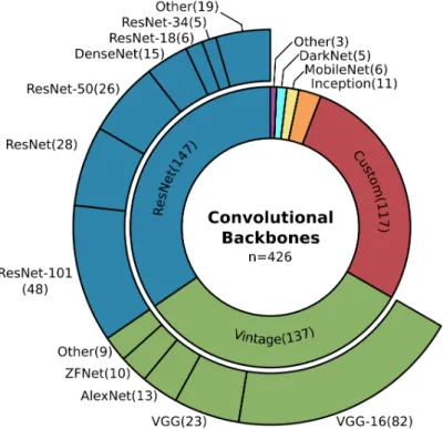
As pictured in Figure8, architectures from the ResNet family and Vintage architectures are the most commonly used feature extractors (67%). The ResNet designs are known for their so-called residual connection, which made training deep networks possible [315]. ResNet models show a good balance in the number of parameters and accuracy, and they are made to be less complex compared to Inception designs [316], and therefore easy to adapt [21]. As the name suggests, the groupVintage contains relatively old architectures like the VGG-Net, introduced between 2012 and 2014 [6,317,318]. They are widely used as feature extractors since their early occurrence but compared to ResNet, they
show a lower accuracy while using more parameters [21,156]. Nevertheless, they appear to be among the most used models.
The third largest group of custom models is often similar toVintagedesigns in their combination of stacked convolution and pooling operations. Still, single designs are especially made to take remote sensing data characteristics into account [38,61,192,241]. It is important to note the small group of six items which use MobileNets [145,268,319–322], of which five were published in 2019. They describe an onset of interest in parameter efficient models with high accuracy and they prove that such models can compete in Earth observation studies.
Figure 8. Overview of the commonly employed convolutional backbones or feature extractors in image segmentation and object detection. ResNet (35%) as well as Vintage designs (32%), like the VGG-Net, are the most widely used feature extractors, whereas recently developed parameter efficient architectures like the MobileNets (1%) belong to a minority in Earth observation studies.
A closer look at the specific architectures used within the groups ResNet and Vintage reveals that the depth of the architectures used in Earth observation differs from the depth of the best performing models on benchmark datasets in the field of computer vision, see Part I Section3.1[21]. For instance, in computer vision ResNet-152 and VGG-19 perform better on the ImageNet benchmark dataset than their shallower counterparts ResNet-100 and VGG-16 [315,318]. However, the shallower models are more frequently used in Earth observation, see Figure8. The arguments for shallower models in Earth observation as in computer vision and especially ImageNet are manifold but reveal essential insights about remotely sensed data analyzed by deep learning.
The deeper a model, the more parameters it has. This makes it capable of classifying 1000 classes precisely, as necessary for ImageNet, but that many parameters are not needed for a 2–20 class remote sensing application. It is even more likely that such a number of free parameters could easily overfit the model. In case the Earth observation dataset is too small, many such parameters cannot be sufficiently trained, hence shallower networks which mostly have fewer parameters are in favor [38]. Also, with fewer parameters, the processable tile size of a remote sensing scene increases which minimizes border effects, allows more context and contributes to less noisy results [216]. However, since spatially tiny targets characterize remote sensing data, a deep feature extractor can easily oversee those spatially small details. With the depth of a model, the so-called receptive field grows, and the final
features extracted subsequently are no longer aware of tiny objects and fine-grained borders. Hence to preserve their information, a shallower convolutional backbone is one solution [323,324]. Finally, many studies decide on a shallower model, even when a deeper model gains a higher accuracy since the shallower model has a much better accuracy-parameter ratio and is considered computationally superior [38,118,156,325].
This reasoning reflects the overall usage of shallower architectures in the reviewed studies, where the ResNet models and the VGG models of the Vintage architectures can be considered established convolutional backbones for Earth observation applications.
When discussing convolutional backbones as well as the similarities and differences between Earth observation and computer vision, transfer learning is an important issue to highlight. In transfer learning, the convolutional backbone of a deep-learning model is pre-trained on a dataset which often comes from another domain and then fine-tuned on a smaller dataset of the target domain. The idea is to use a large dataset which initially teaches the model to understand basic feature extraction so that it starts with a better intuition when it first sees data of the target domain. Of the 429 reviewed papers, 38% used a transfer learning approach, of which 63% used the pre-trained weights of the ImageNet dataset. This makes weights pre-trained on ImageNet the most widely used for transfer learning approaches in Earth observation. Even though many examples exist where transfer learned models are performing better than models trained from scratch [157,281,326], this general assumption cannot be made in every case. One example is that models pre-trained on ImageNet are optimized for RGB images. Analyzing more than three channels is not directly possible with weights that were pre-trained on RGB data [304,327]. However, expanding the pre-trained input channels is possible [157], for instance, by doubling the first filter banks of the first convolution, as demonstrated by Bishke et al. [328]. A more critical issue is highlighted in studies, which investigated radar imagery. The speckle and geometrical properties in radar images make them appear very different to natural images. Hence, models pre-trained on ImageNet and fine-tuned on radar imagery perform even worse than the same models trained solely on the radar data [107,205,329]. In conclusion, transfer learning of pre-trained models is an opportunity for better results [114], primarily when optical data is used. In cases where the target dataset strongly differs from the pre-trained dataset, the positive effects can be smaller or even worse than a training approach from scratch [85,107,204,205,329,330].
3.5.2. Image Segmentation
Image segmentation describes the task of pixel wise classification. In order to achieve this, CNNs were first used in the so-called patch-based classification approach, where a convolutional backbone moves with a small input size like 9
×
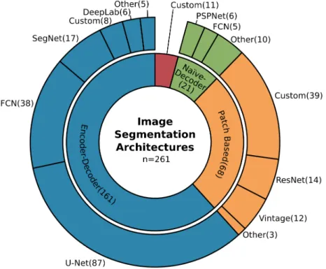
9 pixel over the image and classifies the center pixel or the entire patch upon the extracted features. Later in 2014, FCNs (Fully Convolutional Networks) [331] were introduced, which use the entire image as input and after feature extraction, in this context called the encoder, restores input resolution in the decoder, and classifies each pixel afterwards. The result is an input resolution segmentation mask where each pixel is assigned to a single class. Restoration of the input resolution can be achieved using operations like bilinear interpolation which characterizes the group of naïve-decoder models. Another way to do this is upsampling by trainable deconvolutional layers and merging information of the encoder path with the decoder path, called encoder-decoder models. For further explanation and examples, we refer to Part I Section3.2[21].Figure9illustrates that of the 261 studies which used CNNs for image segmentation, 62% are encoder-decoder models and of these, 54% can be related to the U-Net design. The dominance of encoder-decoder models in Earth observation can be related to an already mentioned property of remote sensing data: the occurrence of tiny and fine-grained targets. Due to the usage of information from early stages in the encoder during upsampling to restore input image resolution, tiny and spatially accurate features have a much stronger influence on the segmentation as in naïve-decoder models [133]. Since such details are often of significant interest in Earth observation applications, encoder-decoder designs became the most favored models.
The U-Net model, initially designed for biomedical image segmentation [332], gained much attention due to its good performance at the time it was published and its clear, structured design. This made it an intensively researched and modified model [21]. In Earth observation applications, image segmentation must deal with blobby results which are contrary to the intent to segment details and fine-grained class boundaries. In order to overcome this contradiction, atrous convolutions and the effective atrous spatial pyramid pooling module (ASPP) from the DeepLab family [333–336] were integrated into the U-Net in multiple studies [133,169,196,215,221,276,285,309,337–342]. Atrous convolution maintains image resolution during feature extraction, which supports the attention to detail [151,163,202,343,344], where the ASPP module also takes spatial context into account which results in less blobby segmentation masks [145,146,345]. In order to gain better results, the final segmentation masks were further refined using CRFs (Conditional Random Fields) [60,165,212,218,346], as well as multiscale segmentation approaches that fuse features of multiple scales before predicting the per pixel class [146,152,189].
Figure 9. Overview of the commonly employed architectures for image segmentation. With 62% encoder-decoder models are the most frequently used especially the U-Net design (33%). Followed by patch-based approaches (26%) and naïve-decoder models (8%).
Other modifications in architecture design which recently received more attention are the so-called attention modules. They originate from the SE (Squeeze and Excitation) module, which multiplies the output of a convolutional operation by trainable weights [347]. Therewith, some results gain more attention than others. In Earth observation, the modules are often called channel and spatial attention modules: where channel attention modules weight the channels that hold the extracted features globally and spatial attention modules weight areas of those channels spatially [128,143,164,197,219,276,342,348,349]. This technique supports the idea that not all features which are extracted by a neural network affect the results equally.
Similarly, there are gated connections, which incorporate feature selection during the decoding process. Instead of passing raw features from the encoder to the decoder to enrich spatial accuracy, these features are refined by gated skip connections [64,148,350]. Another model modification is used in studies which exploit multi-modal data. Data fusion with CNNs offers many possibilities; in so-called early fusion, the input data is fused before or during the first convolutional operation.
On the other hand, late fusion first extracts features in parallel and fuses them deep in the network structure. Between those options, intermediate fusion and even shuffling can increase feature representation [56,58,140,144,146,152,162,188,195,203,346,351–354]. However, all these modifications in architecture design demonstrate that established CNNs for image segmentation need to be adjusted or even explicitly designed to gain state-of-the-art performance in Earth observation [161]. Nevertheless, their modular designs encourage extensive experiments and optimization.
Finally, in Figure9the percentage of patch-based approaches is still high (33%), despite the fact that this technique was one of the first approaches used to segment images and since the emergence of FCN in 2014, was found to be inferior. This is true for high spatial resolution images with rich feature information. Nevertheless, medium to low spatial resolution imagery, which is used in large-scale Earth observation applications like Landsat data, does not necessarily show the kind of spatial feature richness that modern CNN architectures are designed for [186,187,195,199,202,206,211,239,274,355,356]. Hence, patch-based approaches are still a model of choice for this kind of data. This statement is supported by the share of image segmentation studies with a lower spatial resolution above five meters, which is more than twice as high for patch-based models (38%) as in all other approaches (17%), where higher resolution dominates.
3.5.3. Object Detection
In object detection, instances of objects are detected in an image, commonly using a bounding box to describe their position and extent. Two major approaches exist which apply CNNs: two-stage and one-stage detectors. Two-stage detectors first predict regions of interest which contain most probable, class agnostic object candidates and perform adjacent bounding box regression and object classification. One-stage detectors perform object localization, classification and bounding box regression in a single shot. The latter commonly perform faster but are less accurate. A detailed introduction to state-of-the-art CNN-based object detection algorithms is provided in Part I, Section3.3[21].
Figure10shows that in Earth observation applications on object detection, the two-stage approach dominates with 63%. Thereof, the well-established R-CNN models [357] are the most used and of those, 73% belong to the Faster R-CNN design [358].
Like the U-Net architecture in image segmentation, R-CNN models are known for their modularity, which makes the model a good starting point for customization. Another argument for using two-stage approaches is better accuracy, even when their computational consumption is relatively high. One-stage detectors were also used and modified to better fit the needs of Earth observation applications, especially in studies where processing speed is critical or hardware limited [82,292,321,359,360]. The SSD [361] and YOLO [362–364] models are among the most widely used, which can be related to their good performance and extensive documentation, experiments and advancements in computer vision.
Similar to the challenges faced in image segmentation, tiny objects, which can be densely cluttered and with an arbitrary rotation, are the main challenges in object detection. In Section3.4, it was already reported that predicting rotated bounding boxes contribute to better results for specific applications. 73% of the models capable of predicting the angle offset belong to two-stage detectors and 27% to one-stage detectors, which demonstrates an advantage of the modular two-stage architectures for model modifications. However, the architecture modification to predict rotated bounding boxes is one among many to tackle the challenging characteristics of remotely sensed data.
The feature pyramid network (FPN) [365] module is commonly known to enrich extracted features and pass them to the detector on multiple scales. FPN and resembling techniques were leveraged in several studies, which also proposed further modifications of this particular structure [65,80,95,100,124,125,225,227,232,235,236,325,366–375]. Other positive effects on detecting objects in remotely sensed images were found in modifications which compensate for the spatial information loss that happens during feature extraction [228,376]. Similar to image segmentation, a widely used modification is the use of atrous convolutions to maintain high
resolution during feature extraction [106,227,232,326,369,377–379]. In order to shift the model architecture to concentrate on important features, attention modules were incorporated which makes them a widely used architecture modification in both object detection and image segmentation [81,94,96,125,225,230,360,367,375,380,381].
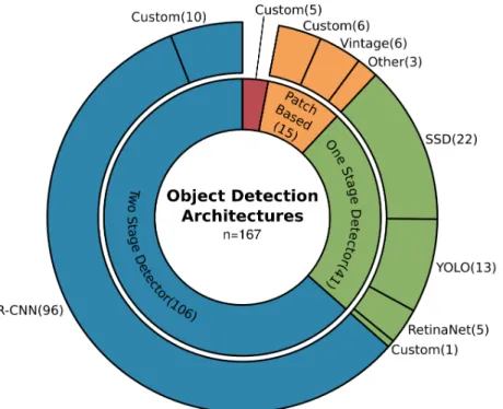
Figure 10.Overview of the commonly employed architectures for object detection. With 63% two-stage detector models are the most frequently used especially designs from the R-CNN family (57%). Followed by one-stage detector models (25%) and patch-based approaches (9%).
Further object detection specific modifications are the applications of deformable convolutions to better extract object related features [232,233,372,377,382,383], as well as to specifically take the spatial context of objects into account [78,106,125,230–232,236,366,376]. In order to better exploit complicated training examples, hard example mining is used to focus on challenging situations [117,119,326,384]. As in computer vision, the cascading design of the Faster R-CNN model [385] proved that adaptive intersection over union (IoU see Part I, Section3.2[21]) thresholds are an efficient way for better performance, especially on tiny objects [232,377,386]. Overall, modifications of architectures highly depend on the size, distribution and characteristics of the target defined by the application as well as the used data. For two-stage detectors, Faster R-CNN [358] and its variants of cascading models [385] and Mask R-CNN [387] are the most established and promising designs in Earth observation. 3.6. Deep-Learning Frameworks
As shown in the previous sections, the transfer of deep-learning methods from computer vision to Earth observation is covered by a large share of studies. The majority have a strong focus on method development in which they modify deep-learning architectures, cost functions and optimize model training. However, recently the share of studies which apply deep-learning methods to answer specific geoscientific research questions is getting bigger. Both groups have special requirements on deep-learning frameworks: studies with a focus on method development need to dive deep into model structures and demand flexibility and freedom in customization, whereas studies focusing on application tend to use stable, established and streamlined model building tools.
Different frameworks are known to offer more freedom or more accessible functionality. Pytorch [388] and native TensorFlow [389] offer deep and complex customization, whereas the Keras
API [390] is known for its intuitive handling. Interestingly, with recent studies focusing on applications, Keras is receiving much more attention, as pictured in Figure11. This indicates a user community which prefers established functionalities to use deep learning as a tool, but still wants to have the opportunity to customize. Still, the share of Pytorch and TensorFlow remains high, which points to users who need more freedom to customize their models or optimize their data pipeline.
Figure 11.Temporal development of employed deep-learning frameworks by numbers of studies which reported the chosen framework. Of the 66 Keras-based studies, 47 reported the underlying backend, of which 44 used TensorFlow. This number is not included in the TensorFlow count, presented in the figure.
The usage of the early Caffe framework [391], which at some point forked and one branch eventually became Pytorch, decreases. In contrast, the number of studies which use Pytorch increases, indicating that parts of the Caffe user community turned to Pytorch. All the frameworks pictured in Figure11 are fully open source besides the Matlab-based MatConvNet [392], which shows a comparably smaller share than the open access frameworks. Overall, the increase in deep learning as a tool to answer geoscientific research questions can be seen in the increase of users who select open access, well documented and subsequently more stable frameworks to apply deep learning.
4. Discussion and Future Prospects 4.1. Discussion of the Review Results
The results presented in the previous sections and summarized in Figure12demonstrate that deep learning with CNNs in Earth observation is in an advanced transition phase from computer vision. The main study focus of the reviewed publications was on method development and proof-of-concept studies, which are characterized by using existing datasets or datasets on a smaller spatial scale. These studies are essential to establish and prove the capabilities and limitations of CNNs in Earth observation research. However, recent studies have begun to investigate large-scale applications with CNNs and incorporate CNNs as a major tool in large-scale geoscientific research.
In the following, the reviewed aspects of employed sensor types, datasets, architectures and applications are discussed. The most used sensor types are those which provide optical data with a high to very high spatial resolution. The dominance of RGB data with rich spatial features can be related to the origin of deep learning with CNNs in computer vision, where also rich feature RGB input data drives the development of CNN research. The increasing use of more Earth observation specific data from multispectral and radar sensors shows the progress made in adapting CNNs for remote sensing data. However, for all sensor types, a high spatial resolution is proven to be crucial for extracting objects and fine-grained class boundaries, which can better be detected when strong representational features can be extracted from the input data. When following the motivation of CNNs
in Earth observation towards an inventory of things in order to analyze object dynamics, high spatial resolution data is and will be the main focus of employed sensor types in Earth observation.
Figure 12.Visual summary of the major findings of this review, separated into study focus, datasets, applications, sensors and used architectures, from left to right. The size of the hexagons represents the importance of the labeled topic, except for applications, where the pie chart depicts the shares of the topics.
From the open datasets in Earth observation, the most widely used cover a small range of application topics: building footprints, car, ship and multi-object detection, as well as road network extraction. Even when datasets of further topics exist, and their variation is increasing recently, the majority of the reviewed publications investigate datasets which contain targets of the above-mentioned applications. Hereby, they made progress in extracting and answering research questions of the specific application targets. However, primarily they used such datasets to find solutions on how to optimize CNNs coming from the computer vision domain for analyzing Earth observation data. This strong data-driven method development in the early phase of the transition of CNNs from computer vision to Earth observation is subsequently complemented by studies which created custom datasets. Those studies indicate the recent trend of dataset creation which is driven by research questions of land-surface dynamics. Accompanying this observation in datasets is the shift of the study focus from method development to proof of concept and finally, large-scale studies, which we characterize as the advanced transition phase.
The methodological insights which were made during this transition phase are prominent in the employed architectures and their modifications. For feature extraction, architectures form the ResNet family and Vintage designs like VGG are the most commonly used. Therefore, in Earth observation shallower model variants are chosen, compared to computer vision. The most frequent arguments for