1 2
The older volcanic complexes of S.Miguel, Azores: Nordeste and Povoação 3
Duncan, A.M.* 4
Institute of Biological, Environmental Science & Technology, University of 5
Bedfordshire, Park Square, Luton, LU1 3JU, UK and Department of Geography and 6
Planning, University of Liverpool, Liverpool L69 3BX, UK 7
8
Guest†, J.E. 9
Department of Earth Sciences, University College London, London, WC1E 6BT, UK. 10
11
Wallenstein, N. 12
Centro de Vulcanologia e Avaliação de Riscos Geológicos, Universidade dos Açores, 13
Rua Mãe de Deus, 9501-801, Ponta Delgada, Portugal. 14
15 16
Chester, D.K. 17
Department of Geography and Planning, University of Liverpool, Liverpool L69 3BX, UK 18
and Department of Geography, Liverpool Hope University, L16 9JD, UK 19
20
*Corresponding author A.M. Duncan (A.M.Duncan@liverpool.ac.uk) 21
22
Number of words of text 3845 23
Number of references 21 24
Number of tables1 25
Number of figures 7 26
27
† - Deceased
28
Abbreviated Title 29
The older volcanic complexes of S.Miguel, Azores 30
31
Abstract 32
The oldest part of S. Miguel is to the east of Furnas. Previous research argued that 33
these volcanics belong to a construct called the Nordeste Volcano, a heavily eroded 34
shield which not only extends to the east coast of the island but also underlies 35
Furnas Volcano in the west. On the basis of geomorphological mapping, we argue 36
that Nordeste comprises two volcanic systems: an older Nordeste construct (the 37
Nordeste Volcanic System); and the younger Povoação Volcano which straddles the 38
Lower Basalts which constitute the overwhelming majority of its subaerial products 40
which are exposed in coastal cliff sections. Above the Lower Basalts is a surficial 41
drape of Ankaramites and the Upper Basalts. There is no evidence of large explosive 42
trachytic eruptions from Nordeste Volcanic System. Povoação Volcano comprises an 43
early shield construct, after which the volcano experienced caldera collapse. Post-44
caldera deposits are poorly exposed, but include basaltic, mugearitic and trachytic 45
lavas intercalated by cut and fill sequences. Radiometric dating has yet to resolve 46
fully the absolute ages of the Nordeste and Povoação volcanic systems, but 47
morphology indicates that the former is much older than the latter. 48
49
S. Miguel Island, Azores, is made up of three central volcanoes, each of which has 50
been active in the last 1000 years, and these volcanoes are linked by rift zones of 51
predominantly monogenetic basaltic activity (Fig. 1). Sete Cidades is the central 52
volcano that forms the western end of the island and last erupted about 500 – 600 y 53
BP (Booth et al. 1978, Moore & Rubin 1991; Queiroz et al. 2008; Queiroz et al. 2015 54
– this volume). A basaltic rift zone separates Sete Cidades from Fogo, the central 55
volcano which dominates the middle of the island. This basaltic rift zone with 56
numerous scoria cones is called the Picos Fissural Volcanic System (Ferreira et al.
57
2015 - this volume). The most recent eruption in the Picos Fissural Volcanic System 58
was in 1652. Fogo last erupted in 1563 with a trachytic sub-plinian central eruption, 59
followed a few days later by a basaltic eruption on the lower northwest flank 60
(Wallenstein et al. 1998). Between Fogo and Furnas, the easternmost of the active 61
central volcanoes, lies the Congro Fissural Volcanic System, a rift zone of 62
predominantly scoria cones. Furnas last erupted with a sub-plinian eruption in 1630 63
(Cole et al. 1995, Guest et al. 1999). 64
65
To the east of Furnas is the oldest part of the island first described by Zbyszewski et
66
100,000 years to over 4 Ma. As discussed below, however, Johnson et al. (1998) 68
argue that the age range is much younger. Moore (1990) categorises all these older 69
volcanics as belonging to Nordeste volcano. It is the purpose of this paper to provide 70
more understanding of this oldest part of the island demonstrating that the Nordeste 71
volcano is in fact two separate distinct volcanic systems - Povoação and the older 72
Nordeste - that make up the eastern part of the island. 73
74
Nordeste Volcanic System 75
Previous Work 76
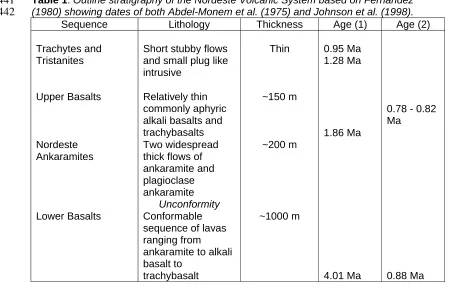
Fernandez (1980) mapped the Nordeste Volcanic System and identified a 1300 m 77
thick exposed sequence and subdivided it into the Trachytes and Tristanites, Upper 78
Basalts, Nordeste Ankaramites and Lower Basalts (Table 1), which together 79
comprise a mildly alkaline suite of volcanic products (Fig. 2). K-Ar dating by Abdel-80
Monem et al. (1975) produced a date of 4.01 Ma for what is considered to be the 81
oldest exposed lava of the Lower Basalts, a date of 1.86 Ma for a lava of the Upper 82
Basalts and dates ranging from 1.28 – 0.95 Ma for the trachytes and tristanites.The 83
complex is cut by a sequence of dykes ranging in composition from ankaramite 84
through alkali basalt to hawaiite in composition. Johnson et al. (1998) measured the 85
palaeomagnetism of a hawaiite dyke showing it to be normally magnetised (Brunhes) 86
whereas the Upper and Lower Basalts are reverse magnetised (Matuyama) and 87
therefore older and not related to the magmatism of the dyke. The work of Fernandez 88
(1980) focuses on petrology and does not define the boundaries of the Nordeste 89
Volcanic System. The lowermost exposed basalts are low in K2O, Na2O and TiO2
90
compared with the rest of the sequence and are transitional in character between 91
mid-ocean ridge basalts and alkali basalts. The Nordeste Volcanic System is 92
interpreted by Moore (1990) as being an eroded shield which underlies Furnas 93
Volcano in the west and extends to the east coast of S. Miguel Island. Though 94
interpreting Povoação as a caldera which is not centred on the main Nordeste 96
massif. Johnson et al. (1998) in a palaeomagnetic study of the lava flows of S. 97
Miguel, carried out new 40Ar/39Ar dating of the Nordeste Volcanic System. These 98
dates of Johnson et al. (1998) give a much younger range than the dates of Abdel-99
Monem et al. (1975) which form the basis of the chronology used by both Fernandez 100
(1980) and Moore (1990). According to Johnson et al. (1998) lava from the Lower 101
Basalt Sequence at the base of the Porto de Nordeste cliff gives a mean age of 102
0.878 Ma. Comparing this with the much older age of 4 Ma quoted by Abdel-Monem 103
et al. (1975), who employed K-Ar dating. Younger dates ranging from 0.82 to 0.85 104
Ma for the Lower Basalts were also obtained by Johnson et al. (1998) from the Praia 105
do Lombo Gordo cliff sequence. Johnson et al. (1998) argue that K-Ar dates are less 106
reliable than those determined by 40Ar/39Ar. 107
108
The dates of the Upper Basalt sequence provided by Johnson et al. (1998) range 109
from 0.78 – 0.82 Ma. If this is the case then the basic magmatism of the Nordeste 110
Volcanic System occurred over a period ranging from 0.78 to 0.88 Ma, i.e. a period of 111
~0.1 Ma, as opposed to ~2.15 Ma as suggested by Fernandez (1980). The 112
palaeomagnetic data of Johnson et al. (1998) show that all the samples analysed 113
from the Lower and Upper Basalts are reversely magnetised (Matuyama) whereas 114
the two ankaramites and one dyke sampled are normally magnetised (Bruhnes) and 115
therefore younger. A younger age for the Nordeste Volcanic System is provided by 116
K-Ar dates of 0.90 Ma and 0.92 Ma obtained from two lavas in cliff sections to the 117
south at Água Retorta (Forjaz personal communication in Johnson et al. 1998). The 118
cliffs to the south of Água Retorta (Fig. 3) lie on the downthrow side of a major WNW-119
ESE fault, the Tronqueira fault (see Fig. 4) and therefore may only represent the 120
upper part of the Nordeste Volcanic System. A summary of the differing age ranges 121
proposed for the Nordeste Volcanic System is presented in Table 1. 122
Tectonics 124
The Nordeste Volcanic System is cut by two major fault trends – NNW/SSE and 125
WNW - ESE and a minor trend NE - SW (Carmo et al. 2005; Carmo et al. 2015 - this 126
volume). The NNW - SSE trend is clearly shown in the northeast part of the island 127
with faults controlling the orientation of sea cliffs on the coast. A major WNW-ESE 128
fault, the Tronqueira fault (Carmo et al. 2015 - this volume), cuts the Nordeste 129
Volcanic System forming a distinctive scarp along the southern margin of the Serra 130
da Tronqueira to the north of Água Retorta (Fig. 5b). From the height of the scarp the 131
fault had a throw of at least 400 m and together with smaller parallel faults has 132
downfaulted the Nordeste Volcanic System to the south. This fault cannot be traced 133
in the Povoação caldera suggesting that it predates the formation of the Povoação 134
Volcano whose lavas are piled up against it. In the Água Retorta area there is a 135
graben developed which has the Tronqueira fault as its northern boundary (Carmo et
136
al. 2015 – this volume). 137
138
The volcanic construct 139
The Nordeste Volcanic System is highly eroded and dissected compared with the 140
active central volcanoes of Sete Cidades, Fogo and Furnas whose subaerial portions 141
date from the last 200,000 years. The less eroded edifice of the Povoação Volcano 142
can be seen banked up against the older Nordeste Volcanic System (Fig. 4). If the 143
dates determined by Johnson et al. (1998) are of the correct order of magnitude, then 144
the age gap - in the range of 600,000 years - between the Nordeste Volcanic System 145
and the younger central volcanoes - is much smaller than was previously thought, 146
and raises the question that on geomorphological grounds the Nordeste Volcanic 147
System appears to be much older than the other centres. An older age, however, for 148
the Nordeste Volcanic System is supported by a recent investigation into high levels 149
of mitochondrial DNA diversity within Oxychilid land snails from S. Miguel (Harris et
150
Pliocene or Pleistocene and argue that these results are more consistent with the 152
older age of the island of about 4 Ma, this is in line with the date of Abdel-Monem et
153
al. (1975) as presented in Table 1. 154
155
The Lower Basalts sequence forms a shield which comprises the overwhelming 156
majority of the subaerial products of the Nordeste Vocanic System. The lava pile is 157
exposed in the cliffs between Algarvia on the north coast and Água Retorta on the 158
south east corner of the island (Fig. 3). The angle of slope from the current peak of 159
the Nordeste Volcanic System, Pico da Vara (1130 m asl), to the top of the coastal 160
cliffs is about 9˚. It should be noted that the current summit will be lower than the 161
original summit as a consequence of erosion, but there is no evidence of caldera 162
collapse of this construct. Cliff sections reveal that the Lower Basalts sequence is 163
made of relatively thin lava flows which are typically of aa type with massive portions 164
up to 3 m in thickness. At the foot of the cliff just south of the Porto de Nordeste at 165
Ponta do Arnel (Fig. 3) the pile of lavas can be seen to cover scoria cone deposits at 166
the base of the pile. The cliffs along the coastline each side of Ponta do Arnel are 167
formed by a well defined fault (Figs. 4, 5a). Ponta do Arnel is formed of younger 168
lavas (post the Lower Basalts sequence) which have spilled over the cliff. The Lower 169
Basalt sequence is also well exposed at Praia do Lombo Gordo. At this locality about 170
50 m above the base of the cliffs a thin layer (75 cm) of weathered orange scoria 171
forms a well defined horizon in the sequence of lavas. 172
173
Inland, the volcanic system is highly vegetated and exposures are limited. The 174
Nordeste Ankaramites and Upper Basalts sequences form a surficial drape on the 175
construct of the Lower Basalts. Johnson et al. (1998) consider that the Nordeste 176
Ankaramites and the Upper Basalts may be at least in part contemporaneous. The 177
small volume of trachytes and tristanites represent the last stage in activity. This 178
fractionation to generate trachytic magmas. There is no evidence, however, that the 180
Nordeste Volcanic System gave rise to major trachytic explosive eruptions. 181
182
The Nordeste Volcanic System has been subjected to considerable erosion and the 183
complexity of this is a reflection of its age. There are several exposures where debris 184
flow deposits may be seen within the Nordeste Volcanic System. Just to the west of 185
Lomba da Fazenda debris flow deposits with clasts of ankaramite are overlain by 186
ankaramite lava suggesting that the debris flow was generated during the 187
emplacement of the Nordeste Ankaramites sequence. This indicates that erosion and 188
generation of debris flows was occurring during the emplacement of the Nordeste 189
Volcanic System. The Ribeira do Guilherme (Figs. 3, 5a) is a major valley cut into the 190
Nordeste products which enters the sea just north of the village of Nordeste. Near to 191
the mouth of the river a fill of alluvium comprising rounded cobbles and boulders of 192
lava crops out on both sides of the valley at c.120 m asl (Fig. 6). The boulders are up 193
to 2 m in size and this, taken together with the poor sorting of the deposits, indicates 194
high energy deposition. The fill perches on the sides of the lava sequence and 195
originally filled the valley up to this level. 196
197
The history of cut and fill is well illustrated on the south east flank of the Nordeste 198
Volcanic System. More than 10 m of very poorly sorted debris flow deposit with 199
rounded lava clasts up to 1 m in diameter forms the base of the cliff section just south 200
of Água Retorta. In the current valley, just north of Fagundas locality, torrent gravels 201
can be seen overlying lava. It is clear that there has been a well developed sequence 202
of cut and fill. 203
204
Generation of debris flows has continued and the history of cut and fill carries on to 205
the present day.The Ribeira Despe-te Que Suas on the northwestern edge of the 206
bridge was built to replace the one destroyed by fluvial activity in 1987 and the river 208
bed which is sometimes dry contains large boulders and cuts a 10 m fill which is 209
poorly sorted with a mixture of rounded and angular clasts and this bears testimony 210
to the high energy discharge which can take place. 211
212
The instability of the cliffs constitutes a current hazard. On the coast to the south of 213
Pedreira locality houses at the foot of the cliff are built on a small platform made of 214
debris flow and debris avalanche deposits. Two of these houses were damaged by 215
debris flows after heavy rainfall in 1998. On the side of the track is a shrine to a man 216
killed by blocks falling in 1961. 217
218
Marine terraces 219
A flat feature at around 150 m asl can be observed on aerial photographs formed 220
above the current sea cliffs on the north coast from São Pedro do Nordestinho to 221
Lomba da Fazenda and on the east coast between Nordeste village and Pedreira 222
(Fig. 4). This we interpret as a possible marine terrace. On the ground this terrace is 223
less clearly visible and has been partially dissected by erosion. 224
225
The terrace is cut into lavas of the Upper Basalts and, therefore, must be younger 226
than 1 Ma. Marine terraces are likely to form at marine high stands but correlating 227
levels is a complex challenge on volcanic islands that may experience significant 228
vertical earth movements and which vary spatially (Moore 1987). An extensive range 229
of marine terraces has been documented in the Canary Islands by Meco et al. 230
(2007). These terraces of Miocene-Pliocene age (4 – 9 Ma) range in altitude up to 231
120 m above current sea level. Only the terraces at the lowest heights (less than 20 232
m asl) could be aligned with higher sea levels before the advance of northern 233
hemisphere ice sheets (c. 5 Ma). Meco et al. (2007) argue that the range in 234
the younger volcanic edifices to the west generating increased lithostatic load on the 236
crust. In the Azores, on Santa Maria, the oldest island in the archipelago, Serralheiro 237
& Madeira (1990) describe a sequence of Pliocene-Quaternary marine levels from 238
160 m asl down to the youngest at 5 m asl. This sequence was formed after Santa 239
Maria ceased to be volcanically active in the Middle Pliocene. On the island of Flores, 240
Azevedo & Portugal Ferreira (1999) report marine terraces, which formed at different 241
stages during the volcanic history of the island. The oldest and highest terrace at 242
c.250 m asl formed between 500,000 and 250,000 BP. There is also a terrace at 243
c.100 m asl with a suggested age of 300,000 BP. Azevedo & Portugal Ferreira 244
(1999) argue that Flores experienced intensive volcano-tectonic uplift during the 245
growth of the volcanic island. Episodes of localised uplift and subsidence in 246
developing volcanic islands frustrates regional correlation of terrace levels. 247
248
The terrace feature on Nordeste is not definitive and no in situ marine deposits have 249
been identified. But as illustrated by the example on Flores, volcano-tectonic uplift of 250
100 m is not unrealistic. The significant erosion and dissection of Nordeste Volcanic 251
System may explain the lack of preservation of any deposits. 252
253
At São Pedro do Nordestinho there is a substantial river terrace that cuts the possible 254
marine terrace feature. No in situ fluvial material was found, but a large number of 255
rounded cobbles and boulders occur in walls or where they have been cleared from 256
fields into piles of rocks. A smaller river terrace occurs on the east coast at Pedreira, 257
where a valley cuts through the marine terrace. 258
259
Povoação Volcano 260
Moore (1990) notes that the Povoação caldera is cut into the Nordeste shield on its 261
southern side. The centre of the Povoação caldera is located 7 km SSW from Pico 262
Povoação caldera stretches from the rim down to the north coast. Povoação is much 264
less dissected than Nordeste and appears to be morphologically younger (Fig. 4). 265
We propose that Povoação is a volcano in its own right and younger than the 266
Nordeste Volcanic System. 267
268
Measured from its footwall, the Povoação caldera is an oval shaped bowl 6 x 3.5 km 269
(long axis E-W); the rim is highest on the north side and dips down to the coast on 270
the south (Fig. 4). The town of Povoação is located on the coast where the rivers that 271
drain the caldera have cut through the rim to the sea. The caldera fault, which is 272
interpreted to run at the foot of the caldera slope can be traced just inland from the 273
coast (Fig. 4). The oval-shaped morphology with the long axis parallel to the coast 274
and the fact that the depression is not open to the sea, does not support it being 275
either an erosional feature or a sector collapse, because such a collapse would be 276
elongated perpendicular to the coast. 277
278
The lavas that make up the early shield construct of Povoação are exposed in the 279
sea cliffs to the west of Povoação village. There is good exposure of pre-caldera 280
material in the sea cliff that extends eastwards from the town of Povoação for 1.5 km 281
to a small headland. This coastline appears to be fault controlled. The sequence dips 282
westwards and there are a number of faults which mostly downthrow to the west. At 283
the headland are crudely bedded agglutinates and thin lavas. These are overlain by 284
basic lavas intercalated with a thick scoria/breccia sequence. Pale grey dykes of 285
intermediate composition trending NW-SE cut the sequence and one dyke feeds a 286
lava flow or sill. At the west end of the sequence there appears to be a vent system 287
with a cone overlain by basaltic lavas. This is illustrated in Fig. 7. The deposits as 288
described above appear to be vent facies (actual vent material or proximal deposits) 289
and this may indicate the fault here was active prior to caldera formation. This vent 290
Povoação welded ignimbrite, the Povoação Ignimbrite, from Furnas Volcano (Duncan 292
et al. 1999) lies on top of the sequence. It needs to be emphasised that the 293
Povoação Ignimbrite though well exposed in the Povoação caldera was erupted from 294
Furnas Volcano about 30, 000 BP (Guest et al. 1999). 295
296
The post-caldera deposits are poorly exposed. Products from Furnas Volcano, the 297
Povoação Ignimbrite and younger tephra, form the uppermost sequence emplaced 298
within the caldera. On the sides of interfluves within the Povoação caldera horizontal 299
basaltic, mugearitic and trachytic lavas are exposed intercalated with cut and fill 300
material. On the northern wall of the caldera, Moore (1990) recognises more than 301
100 m thickness of trachytic pyroclastic flow and fall deposits which preceded caldera 302
collapse. It is likely that there was more than one eruption associated with the 303
collapse. 304
305
A large volume of orange trachytic pyroclastics are found in places mantling the 306
eroded edifice of the Nordeste Volcanic System and reworked in the valleys cut into 307
the Nordeste shield. The alluvium which filled the Ribeira do Guilherme has a matrix 308
rich in weathered yellow ash and lapilli. In a quarry by the church at Pedreira (Fig. 3) 309
orange ash can be seen overlying a well developed soil on top of Nordeste Volcanic 310
System lavas and scoria. A dyke cuts the lava and scoria sequence but not the soil 311
and orange ashes. On the high ground between Faial da Terra and Água Retorta 312
mantling orange ashes with scattered lapilli crop out, in places these are reworked 313
and in one exposure a rotten ignimbrite occurs at the top of the sequence. The 314
topography of the down faulted block of the Nordeste Volcanic System, south of the 315
Tronqueira fault, has a subdued relief as it is mantled by the orange pyroclastics. 316
These pyroclastics clearly postdate Nordeste but these deposits have not been 317
located at the top of the Povoação caldera fill which would be expected if they had 318
trachytic pyroclastics that postdate Nordeste, but appear to be older than Furnas, are 320
the products of the Povoação caldera forming eruptions and may correlate with the 321
products described by Moore (1990, see above). 322
323
Conclusions 324
The research reported in this paper argues that the previously defined Nordeste 325
Volcano is two separate volcanic constructs, the Nordeste Volcanic System, and the 326
younger Povoação Volcano. The edifice of the Nordeste Volcanic System is more 327
highly dissected than that of the Povoação Volcano and, morphologically, the edifice 328
of Povoação can be seen to wrap around the Nordeste Volcanic System. The 329
Nordeste Volcanic System is made up of predominantly basaltic lavas, together with 330
the products of intense erosion which occurred both during and after the activity of 331
the volcano. No evidence has been found of caldera formation on the Nordeste 332
Volcanic System and no products of major trachytic explosive activity have been 333
identified. Povoação Volcano has an early lava shield followed by explosive trachytic 334
activity and caldera collapse. It is proposed that the large volume of orange trachytic 335
ash that mantles part of the Nordeste Volcanic System is interpreted as possible 336
products of the Povoação caldera forming eruptions. The caldera fill is largely 337
obscured by products from the younger Furnas Volcano to the west. The age gap 338
between the Nordeste Volcanic System and the other volcanic centres of S. Miguel 339
remains to be resolved. The recent dating work of Johnson et al. (1998) suggests 340
that this age gap may be only a few hundred thousand years as opposed to the 3 Ma 341
as previously thought. Such a short time gap does not agree well with the 342
morphological evidence and recent work on the diversity within Oxychilid land snails 343
(Harris et al. 2013) that suggests that the Nordeste Volcanic System is much older 344
than the other centres. 345
346
Abdel-Monem, A.A., Fernandez, L.A. & Boone, G.M. 1975. K-Ar ages from the 348
eastern Azores group (Santa Maria, São Miguel and the Formigas Islands). Lithos, 8, 349
247-254. 350
351
Azevedo, J.M.M. & Portugal Ferreira, M.R. 1999. Volcanic gaps and subaerial 352
records of palaeo-sea-levels on Flores Island (Azores): tectonic and morphological 353
implications. Geodynamics, 28, 117-129. 354
355
Booth, B., Walker, G.P.L. & Croasdale, R. 1978. A quantitative study of five 356
thousand years of volcanism on São Miguel Azores. Philosophical Transactions of
357
the Royal Society of London, Series A 228, 271-319. 358
359
Carmo, R., Madeira, J. & Gaspar, J.L. 2005. Structural geology of Povoação-360
Nordeste region (S. Miguel Island, Azores). Geophysical Research Abstracts, 7, 361
EGU05-A-10454, SRef-ID: 1607-7962/gra/EGU05-A-10454. 362
363
Carmo, R., Madeira, J., Ferreira, T., Queiroz, G. & Hipólito, A. 2015. Volcano-tectonic 364
structures of S. Miguel Island, Azores. In: Gaspar, J.L., Guest, J.E., Duncan, A.M., 365
Chester, D. & Barriga, F. (eds.) Volcanic Geology of S. Miguel Island (Azores 366
Archipelago), Geological Society of London Memoir. 367
368
Cole, P.D., Queiroz, G, Wallenstein, N., Gaspar, J.L., Duncan, A.M. & Guest, J.E. 369
1995. An historic subplinian/phreatomagmatic eruption: the 1630 AD eruption of 370
Furnas volcano, São Miguel, Azores. Journal of Volcanology and Geothermal
371
Research, 69, 117-135. 372
Duncan, A.M., Queiroz, G., Guest, J.E., Cole, P.D., Wallenstein, N., Pacheco, J.M. 374
1999. The Povoação Ignimbrite, Furnas Volcano, São Miguel, Azores. Journal of
375
Volcanology and Geothermal Research,92, 55-65. 376
377
Fernandez, L.A. 1980. Geology and petrology of the Nordeste volcanic complex, São 378
Miguel, Azores: Summary. Geological Society of America Bulletin, 91, 675-680. 379
380
Ferreira, T., Gomes, A. & Gaspar, J.L. 2015. Distribution and significance of basaltic 381
eruptive centres: S. Miguel, Azores In: Gaspar, J.L., Guest, J.E., Duncan, A.M., 382
Chester, D. & Barriga, F. (eds.) Volcanic Geology of S. Miguel Island (Azores 383
Archipelago), Geological Society of London Memoir. 384
385
Guest, J.E., Gaspar, J.L., Cole, P.D., Queiroz, G., Duncan, A.M., Wallenstein, N., 386
Ferreira, T. & Pacheco, J.M. 1999 Volcanic geology of Furnas Volcano, São Miguel, 387
Azores. Journal of Volcanology and Geothermal Research, 92, 1-29. 388
389
Harris, J.D., Ferreira, A.F. & De Frias Martins A.M. 2013. High levels of mitochondrial 390
DNA diversity within Oxychilid land snails (subgenus Drouetia Gude, 1911) from São 391
Miguel island, Azores. Journal of Molluscan Studies, 79, 177-182. 392
393
Johnson, C.L., Wijbrans, J.R., Constable, C.G., Gee, J., Staudigal, H., Tauxe, L., 394
Forjaz, V.-H. & Salgueiro, M. 1998. 40Ar/39Ar ages and Azores palaeomagnetism of 395
São Miguel lavas. Earth and Planetary Science Letters, 160, 637-649. 396
397
Meco, J., Scaillet, S., Guillou, H., Lomosahitz, A., Carracedo, J.C., Ballester, J., 398
Betancort, J.-F. & Cilleros, A. 2007. Evidence for long term uplift on the Canary 399
Islands from emergent Mio-Pliocene littoral deposits. Global and Planetary Change, 400
402
Moore, J.G. 1987. Subsidence in the Hawaiian Ridge. In Decker, W., Wright, T.L., 403
Stauffer, P.H. (Eds) Volcanism in Hawaii U.S. Geological Survey Professional Paper 404
1350, 85-100. 405
406
Moore, R.B. 1990. Volcanic geology and eruption frequency, São Miguel, Azores. 407
Bulletin of Volcanology, 52, 602-614. 408
409
Moore, R.B. & Rubin, M. 1991. Radiocarbon dates for lava flows and pyroclastic 410
deposits on São Miguel, Azores. Radiocarbon, 33, 151-164. 411
412
Queiroz, G., Pacheco, J.M., Gaspar, J.L., Aspinall, W.P., Guest, J.E. & Ferreira, T. 413
2008. The last 5000 years of activity at Sete Cidades volcano (S. Miguel Island, 414
Azores): implications for hazard assessment. Journal of Volcanology and Geothermal
415
Research, 178, 562-573. 416
417
Queiroz, G., Gaspar, J.L.,Guest, J., Gomes, A. & Almeida M. H. 2015. Eruptive 418
history and evolution of Sete Cidades Volcano, S. Miguel Island, Azores In: Gaspar, 419
J.L., Guest, J.E., Duncan, A.M., Chester, D. & Barriga, F. (eds.) Volcanic Geology of 420
S. Miguel Island (Azores Archipelago), Geological Society of London Memoir. 421
422
Serralheiro, A. & Madeira, J. 1990. Stratigraphy and geochronology of Santa Maria 423
Island (Azores). Livro de Homonagem a Carlos Romariz, Dep. Geologia F.C. Lisboa, 424
357-375. 425
426
Wallenstein, N., Duncan, A.M., Almeida, M.-H. & Pacheco, J. 1998. A erupção de 427
1563 do Pico do Sapateiro, São Miguel (Açores). Proceedings of the 1a Assembleia
Luso Espanhola de Geodesia e Geofísica (electronic format). Spain, Almeria,
429
February 1998, 6p. 430
431
Zbyszewski, G., Moitinho de Almeida, F., Veiga Ferreira, O. & Torre de Assunção, C. 432
1958 Carta Geológica de Portugal ne escala de 1:50,000. Publicações dos Serviços
433
Geológicos de Portugal 37p., Lisboa. 434
Table 1: Outline stratigraphy of the Nordeste Volcanic System based on Fernandez
441
(1980) showing dates of both Abdel-Monem et al. (1975) and Johnson et al. (1998).
442
Sequence Lithology Thickness Age (1) Age (2)
Trachytes and Tristanites
Short stubby flows and small plug like intrusive
Thin 0.95 Ma 1.28 Ma
Upper Basalts Relatively thin commonly aphyric alkali basalts and trachybasalts
~150 m
1.86 Ma
0.78 - 0.82 Ma
Nordeste Ankaramites
Two widespread thick flows of ankaramite and plagioclase ankaramite
~200 m
Unconformity
Lower Basalts Conformable sequence of lavas ranging from ankaramite to alkali basalt to
trachybasalt
~1000 m
4.01 Ma 0.88 Ma
(1) K-Ar dates of Abdel-Monem et al. 1975 (2) Ar-Ar dates of Johnson et al. 1998 443
Figure captions 445
446
Figure 1. General location map of S.Miguel and the Nordeste Volcanic System 447
448
Figure 2. Total Alkalis Silica plot showing compositional range of volcanics of the 449
Nordeste Volcanic System (data from Fernandez 1980). 450
451
Figure 3. Location map of the Nordeste and Povoação area. 452
453
Figure 4. Digital Elevation Model of Nordeste and Povoção Volcanic Systems, 454
showing geomorphological relationships and tectonic features. Tr is Tronqueira Fault. 455
The volcanic limits (thick black lines) represent the boundaries of the 456
geomorphological expression of the volcanic constructs of Furnas, Povoação and 457
Nordeste Volcanic Systems. The younger, less dissected, edifice of Povoação can 458
be seen banked up against the older Nordeste Volcanic System. The volcanic limits 459
do not represent geological boundaries as such, for example products from Furnas 460
Volcanic System drape over the adjacent Povoação caldera rim. Some tectonic 461
information from Carmo et al. (2015 – this volume) is included in this figure. 462
463
Figure 5. 464
a) View looking north with the northeast coast showing the cliffs along the coastline 465
each side of Ponta do Arnel which are formed by a well defined fault. The Ribeira do 466
Guilherme, which is considered to be fault controlled (Carmo et al. 2015 – this 467
volume) is the major valley entering the sea at the northern end of the fault controlled 468
line of cliffs. 469
b) The east coastline of S. Miguel with the village of Água Retorta in the middle of the 470
photograph with the cliffs at Ponta do Arnel stretching to Nordeste village on the far 471
right. The cliffs are cut largely into the lava pile of the Lower Basalts. To the right of 472
Água Retorta village the fault controlled scarp of the Serra de Tronqueira can be 473
clearly seen. The summit of the Nordeste Volcanic System, Pico da Vara, can be 474
seen rising above the clouds. (Photographs by Paulo Melo) 475
476
Figure 6. Deposit of the alluvial fill material perched on the side of the valley of the 477
Ribeira do Guilherme near Nordeste village. 478
479
Figure 7. Coastal cliff section immediately east of the mouth of the river at Povoação 480
village. The cliff exposes pre-caldera deposits showing what appears to be vent 481
material (A) overlain by thin basaltic lavas coastal section (B). On top of the 482
sequence lies the massive welded Povoação Ignimbrite (C) erupted from Furnas 483
Volcano to the west. 484