IMPACT OF MINING WASTES ON
GROUNDWATER QUALITY IN THE
PROVINCE JERADA
(EASTERN MOROCCO)
BATTIOUI MOUNIA
Université Mohamed Premier (UMP). Laboratoire d'hydrobiologie et écologie générale Centre Oriental des Sciences et Technologies de l’Eau (COSTE), Boîtepostale n° 524, code postal 60.000, Oujda, MAROC
(Corresponding author) E-mail: [email protected]
BENZAZOUA MOSTAPHA
Université du Québec en Abitibi-Témiscamingue. Chaire de recherche du Canada en gestion intégrée des rejets miniers. Institut de recherche en mines et en environnement, 445, Boul. de l’Université
Rouyn-Noranda, QC, J9X 5E4 CANADA E-mail:[email protected]
HAKKOU RACHID
Université Cadi Ayyad.Faculté des Sciences et Techniques. Département de Chimie.B.P549 /40000 E-mail:[email protected]
BOUZAHZAH HASSAN
Université du Québec en Abitibi-Témiscamingue. Chaire de recherche du Canada en gestion intégrée des rejets miniers. Institut de recherche en mines et en environnement, 445, Boul. de l’Université
Rouyn-Noranda, QC, J9X 5E4 CANADA E-mail:[email protected]
JILALI ABDELHAKIM
Université Mohamed Premier (UMP). Laboratoire des Gîtes minéraux, Hydrogéologie & Environnement Faculté des Sciences, B.P. 717, Oujda 60000, Maroc
Email : [email protected]
SBAA MOHAMED
Université Mohamed Premier (UMP). Centre Oriental des Sciences et Technologies de l’Eau (COSTE), Boîte postale n° 524, code postal 60.000, Oujda, MAROC
E-mail: [email protected]
Abstract.
Jerada coal mine is located in north east of Morocco, and closed in late 2001.Today the quantity stored is about 15 to 20 million tonnes. These releases contain significant levels of accompanying elements or secondary minerals such as iron sulfides (pyrite) and their oxidation products.Monitor the groundwater quality was developed in the region in order to assess the quality of these waters and to estimate the risk of contamination. The study focused on 35 wells spread to cover almost all of the study area.Two main sampling campaigns were conducted, the first one in October 2010, the second in July 2011.The pH of the different measuring points is generally between 6 and alkaline tending 8 show groundwater level in the region.The results obtained by ion chromatography show an average sulphate concentration of about 700mg/l.These concentrations are much higher in the wet season than the dry season. The average nitrate levels are in the range of 300mg/l while those chlorides are of the order of 418 mg/l.The analysis by emission spectrometry with inductively coupled plasma (ICP) showed mean concentrations of calcium in the range of 170mg/l,340mg/l for sodium and 309mg/l for magnesium while contents of Al, As, Cd remain negligible or even below the detection limit.The results of physico-chemical analysis of groundwater level in the province of Jerada show high pollution level in the region.
Keywords: Mine anthracite mining waste, sulfates, nitrates, chlorides, groundwater Jerada, Morocco Oriental.
I.Introduction
Mining activities generate economic benefits for many countries around the world. However, the mining industry generates large quantities of solid and liquid wastes that may have negative impacts on the environment if not properly managed.Mining activities generate large volumes of waste rock and tailings at different stages of extraction and mineral treatment.Tailings or tailings are usually stored in storage areas near the mine and can cover areas of several dozen hectares [Bussière et al, (2005)].
They are usually left without any treatment. The exploitation of base metals, precious metals and coal, releases are generally rich in metal sulfides, mainly iron sulfides (pyrite and pyrrhotite).The presence of sulphide minerals in the waste (eg: pyrite), atmospheric elements (water, air) leads to the oxidation of the tailings. Then there is production of sulfuric acid (H2SO4), where decreases in pH also promote the leaching of toxic metals from waste [Akcil and Koldas, (2006)].This is called acid mine drainage (AMD).
The DMA is the result of a series of chemical and biochemical reactions [Kleinmann et al, (1981. Ritcey,(1989)].DMA products can migrate from storage areas and reach adjacent aquifers, surface water and surrounding land and affecting the quality of water resources and soil [Gunsinger et al. (2006b)]. The DMA can cause acidification of lakes and rivers [Espana et al, (2006)], thus compromising the lives of aquatic plants and other living organisms in the water or on the banks [Grout and Levings, (2001)].By acid leaching, some heavy metals may be released [Lei et al., (2010)] and become bioavailable in the food chain, threatening the health and even the life of biological organisms [Zis et al., (2004)].The oxidation of sulphides in the tailings may continue for long periods ranging from ten years to centuries [Lappako, (1990)].All sulfur residues are not necessarily DMA producers. In rich contexts neutralizing minerals, acidity produced following oxidation of sulfides is buffered.
The Oriental region, with its rich subsoil, has made a mining vocation a very long time, it has many fields metallic and nonmetallic clues spread throughout the region.Mines of Upper Carboniferous anthracite mines were exploited industrially from 1936 to 2001in Jerada, south of Oujda. However, the mining activity which was previously the main economic activity in the region has declined sharply, particularly after the closure of Jerada anthracitemine at the end of 2001.Since then, Moroccodoes almostnot producefossil fuels. Indeed advanced reservations making mining more difficult and expensive, coupled with falling commodity prices on the world market produced exhaustion, combined to condemn the use of coal at the region.
Jerada anthracite mine located in the country Horsts at the northern edge of the Highlands generated during the operating period about 20 million tonnes consisting mainly of shale that was stored in tailings dumps. These are located near homes and spread throughout the city with a total population in 2004 was estimated at about 50,000 inhabitants in the urban areas.
The remaining time of closure reserves were estimated at 10 million tons. Today, artisanal mining activity recovery reserves the superficial part is developed for theshallow layers A, B, C and F (less than 60-70 m), or the secondary coverage is absent [Chellai et al,(2011)].These small mines operate under minimum safety conditions of production (about 5000t/year) and were sold by wholesalers to the power plant or beyond.Jerada water resources, which could be used for human consumption are permanently degraded by various pollution sources manly the discharge of waste water, tailings, etc.
Jerada coal is anthracite containing 2-5% pyrite synergistic fine or medium grain [Owodenko,(1976)]. The tailings are potentially Jerada DMA generators. Numerous studies of mine drainage (leaching by meteoric waters of coal mining residues) showed a variety of preventing situations formulating simple conclusions. The objective of this study, is to assess the risks imposed by these releases and the degree of groundwater contamination inJerada mining basin and highlight the main sources of regional water pollution. Therefore, an analysis of geological and hydrogeological settings in addition to a program of sampling and physico-chemical analyzes of water upstream and downstream of the mine were made.
II. Materials and Methods 1. Study area
The Jerada coalfield is located north-east of Morocco 60 km south of the city of Oujda. The territory consists of a mountain (chain of horst) and the highlands in the south (Fig. 1).
Figure 1: Urban center and water system of the city of Jerada(Morocco)
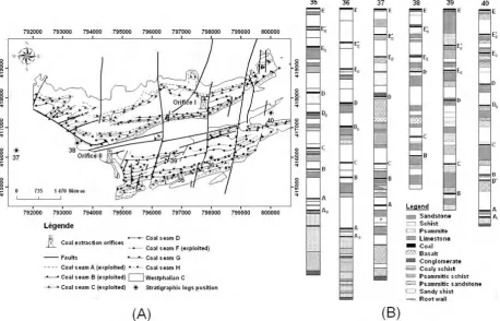
Jerada basin is located in the area of the Meseta Horsts Eastern Moroccan (Fig.2). The series begins with the Paleozoic to upper Visean. Volcano-sedimentary series little pleated and not metamorphic of early Visean times including a series disconformably overlies on schist epimetamorphic deformed of Devonian age.The final puckering in syncline Westphalian coal basin Jerada dates from the Westphalian D [Izart, (1991)]. A graben was opened right from the Upper Visean between two continental horsts [Desteucq, (1982)]. The Westphalian A is seafarer and rests conformably on the Visean-Namurian seafarer also. The coalfields are dated Westphalian B and C. Westphalian C is known to a depth of approximately 500 m [Owodenko(1976; Desteucq et al., (1988; Izart(1990); Essamoud and Courel, (1996)] and contains eight layers of coal, A to H (Fig.2).
Figure 2: Map showing (A) the distribution of Westphalian coal seams, (B) different stratigraphic sections (35,36,37,38,39 and 40) at the coalfield of Jerada (Owodenko, 1976)
The Seat of Jerada is only known in the West of the button hole, following the flooding of the basin, and its area of outcrop is thus very reduced compared to the series of SidiBrahim and Djebelechakhar. To the east, not flush, a few meters from stamps sterile axes in synclines above the basal conglomerate (Fig.2). To the east, in the axes synclines outcrop only a few meters above the stamps sterile basal conglomerate (Fig.2). The lower limit is the pebble conglomerate Lydian or large poudingue, whose thickness is from 1 to 5 meters, and the roof wall is sandstone. In fine sandstone, more abundant in the East and West are embedded phtanites black pebble and pebbles quartzite and quartz sandstone color variable, ranging from white to brown.
Figure 3: Annual rainfall in the province of Jerada station Guefait.
2. Sampling strategy and water analysis
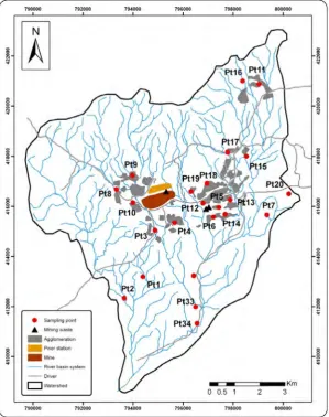
For water sampling, Two sampling campaigns were conducted: the first was during high water (10, 16 and 23 October 2010) and the second one was in low water period (July 2011) were sampled in the referenced wells (P1 to P35) which locations were identified from a field scouting, with the aim to define the mining basin Jerada (Fig. 4).
Figure 4: Spatial distribution of groundwater sampling points at the province of Jerada
The water extraction was carried out in polyethylene bottles previously soaked in 10% nitric acid, and then rinsed thoroughly with distilled water after that with well water.Water samples were immediately cooled to 4°C using using portable icebox, temperature, pH and electrical conductivity were measured respectively using probes type (WTW530, LUTRONTM) and (WTW 197 LUTRON TM).
Once in the laboratory, each water sample was divided into two. Necessary for the determination of heavy metal concentrations volume was acidified by adding nitric acid to 1% and stored in polyethylene bottles at 4 ° C. The concentrations of major ions (Ca2+, Mg2 +, Na+ and K+) and metals (Fe, Al, and Si) were determined by ICP-AES at the Faculty of Science and Technology of Marrakech. The remaining volume was directly filtered through filters with a porosity of 0.45 microns for the determination of levels of sulphate (SO42-), nitrate (NO3-) and chloride (Cl-) type by ion chromatography (Metrohm, 861 Advanced Compact IC).
III. Results and discussion
The results of physico-chemical analysis of groundwater level in the province of Jerada are reported in Table (1), referring to the drinking water standards set by the World Health Organization (WHO), these waters testify to a fairly significant mineralization with electrical conductivities ranging from 150µS/cm and 9600µS/cm at 25 ° C (Tab.1).
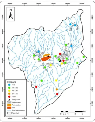
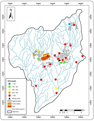
Sulfates SO2-4 are at the top of major anions identified with concentrations ranging from 43mg/l and 1800 mg / l (Fig.5). In the wet season, 77% of the wells far exceed the drinking water standards (250mg/l) set by WHO. These concentrations give a bitter taste to water and may have a laxative effect [McKee and Wolf, (1963)]. The sulfate minerals also promote corrosion of plumbing and building materials well. This could be caused by the formation of sulfuric acid as a product of reactions involving the oxidation of pyrite (FeS2) [Bell and Bullock, (2001), in the presence of atmospheric oxygen and moisture. The oxidation of pyrite can be described as follows:
s: solid, g: gas, aq: aqueous.
Figure 5: Spatial variation of the sulphate content (mg/l) of groundwater in the province Jerada (dry season)
The high concentrations of sulfates SO42- may reflect a mining pollution from different deposits placed in the urban center in the province of Jerada. Besides the well with a very high concentration of sulphates are usually those close to these deposits. This pollution is much more pronounced in the wet season (due to greater leaching of sulphates) in the dry period (Fig.5and 6). The pyrite oxidation is a natural process that occurs in many mining environments. However, the oxidation of pyrite in the tailings impoundment is enhanced due to the greater accessibility of air through the mine waste from mineral undeveloped and the largest area of sulphides following ore processing. The departure of sulfates from slag heaps confirms the existence of an acid mine drainage on the study sites associated with a decrease in pH of the analyzed waters. However, the pH values are neutral or near neutral pH between 6 and 7 (Tab.1) because water from the leaching heaps infiltrate an environment rich in calcium deposits [Raynal (1961) , Ruellan, (1971); Benzaazoua et al, (2002)], where the neutralization of the acidity produced by the reaction below:
2CaCO3+2H2SO4 2CaSO4+2CO2+2H2O (2)
Table 1: Physico-chemical parametersof groundwaterinthe provinceJerada
****: Inferieur to detection limit
Echantillons pH CE (µs/cm) Ca (mg/l) Na ( mg/l) Mg ( mg/l) Al (mg/l) Fe (mg/l) K (mg/l)
SS SH SS SH SS SH SS SH SS SH SS SH SS SH SS SH
Pt1 7,68 6,80 4120 96.66 989,6 80,29 335.7 344.5 218.4 156,33 0.257 **** **** **** 9.053 11,65
Pt2 7,44 7,20 3670 123.75 4292 213,00 313.4 136,80 155.2 379,63 0.21 **** **** **** **** 6,87
Pt3 7,25 7,40 9650 292.8 2045 218,68 235.8 535,80 159.05 135,40 0.427 **** **** **** 0.001 6,33
Pt4 6,86 6,90 2980 270.15 1804 196,56 564.1 281,70 580.95 137,15 0.5 **** **** **** 5.841 2,32
Pt5 7,45 7,60 4500 281.75 1910 281,67 85.09 222,70 90.865 131,70 0.357 **** **** **** **** 7,96
Pt6 7,50 7,20 2150 210.8 1027 270,30 202.4 122,55 200.05 214,25 0.266 **** **** **** 0.906 5,22
Pt7 7,64 6,80 1720 107.45 1612 243,30 87.76 319,65 55.47 167,95 0.108 **** **** **** 15.33 7,82
Pt8 7,77 7,20 2120 64.08 1304 120,30 119 170,10 38.225 161,27 0.238 **** **** **** **** 4,85
Pt9 8,56 8,20 3450 176.4 1122 388,25 94.93 121,00 134.15 160,80 0.44 **** **** **** **** 7,03
Pt10 7,46 7,40 3130 101.23 2047 120,45 344.5 207.4 548.9 161,47 0.507 **** **** **** 3.508 4,15
Pt11 7,47 6,90 1450 85.435 1452 97,61 213.5 132,10 161.2 51,07 0.219 **** **** **** **** 9,80
Pt12 6,74 7,80 2420 330.25 2174 170,80 110.9 352,00 67.93 181,23 0.155 **** **** **** **** 3,35
Pt13 7,63 7,50 1690 388,3 1392 106,30 110.0 90,42 114.9 203,83 0.424 **** **** **** 0.36 3,50
Pt14 7,12 7,00 2340 342 2364 103,51 169.0 135,55 175.1 39,17 0.337 **** **** **** **** ****
Pt15 7,27 7,30 2060 406,6 1982 125,85 165.4 300,80 210.7 844,60 0.253 **** **** **** 0.631 8,48
Pt16 7,60 7,30 740 67,04 792 727,10 24.98 68,98 61.24 21,97 0.726 **** **** **** 4.973 1,03
Pt17 6,75 6,70 2020 145,3 2162 113,70 113.8 618,30 81.99 189,13 0.132 **** **** **** 4.512 3,03
Pt18 6,97 7,00 3330 182,9 4287 134,78 232.2 34,47 299.9 38,35 0.270 **** **** **** **** ****
Pt19 7,27 7,20 2650 117,8 2294 249,85 207.4 160,40 142.4 109,05 0.087 **** **** **** 6.413 2,72
Pt20 7,82 7,50 1520 115,3 1393 103,50 116.0 94.93 144.6 105,20 0.530 **** **** **** 4.955 1,05
Pt21 7,51 7,60 1940 41,12 2083 200,50 138.8 77,00 85.56 200.05 0.602 **** **** **** 9.118 5,10
Pt22 7,52 7,30 1500 293,2 1347 48,40 112.8 76,85 149.8 55.47 0.111 **** **** **** 4.28 2,57
Pt23 7,16 7,10 2810 116,6 1542 219,60 76.83 136,60 78.63 38.225 0.152 **** **** **** 3.167 5,674
Pt24 6,96 7,20 2580 249,9 19073 168,70 132.6 163,40 214.7 134.15 0.244 **** **** **** 7.487 1,50
Pt25 7,02 6,80 2360 193,6 1048 321,85 216.1 271,20 232.1 548.9 0.148 **** **** **** 6.282 30,52
Pt26 7,20 7,40 530 159,5 768 84,06 48.88 488,60 63.60 228,10 0.382 **** **** **** 15.66 3,94
Pt27 7,38 7,20 200 490,6 183 254,43 493.6 68,20 582.8 90.865 0.086 **** **** **** 2,46 2,42
Pt28 6,74 7,50 2790 230,2 2596 144,05 334.3 1140,00 241.8 348,35 0.613 **** **** **** 6,37 5,36
Pt29 7,04 7,00 1900 167,7 861 182,85 120.1 312,80 149.4 358,80 0.041 **** **** **** **** ****
Pt30 7,25 7,30 150 211,1 105 145,25 197.0 207.4 202.9 713,70 0.275 **** **** **** 1,38 2,71
Pt31 7,17 6,90 1330 443,1 1348 115,25 208.6 344.5 177.6 39,83 0.135 **** **** **** 3,27 1,09
Pt32 7,32 7,40 480 148,4 650 67,04 133.2 334.3 86.19 1140,00 0,183 **** **** **** 12.33 5,82
Pt33 7,09 7,20 5750 383,6 6028 101.23 486.4 132.6 368.2 161.2 0,142 **** **** **** **** ****
Pt34 7,32 7,10 3580 296,5 2891 115,25 95.97 493.6 121.5 67.93 0,175 **** **** **** 3,28 3,19
Echantillons SO4
(mg/l) NO3- (mg/l) Cl- (mg/l)
SS SH SS SH SS SH
Pt1 174,84 686,5 6,33 8,42 341,50 551,1
Pt2 667,70 596,2 12,84 288,3 434,40 582,7
Pt3 197,28 915,3 169,92 106,6 146,11 629,8
Pt4 205,91 954,3 175,60 702,6 269,70 65,09
Pt5 645,38 622,6 21,63 220,5 332,20 551,5
Pt6 204,36 123,72 197,62 501,7 122,16 752,4
Pt7 132,77 854 5,92 395,2 201,97 638,4
Pt8 179,75 384,6 37,10 25,8 158,08 259,8
Pt9 86,09 239,5 663,50 102,6 812,10 180,94
Pt10 160,05 156,6 85,03 474,3 285,47 753,6
Pt11 72,62 612,8 158,14 219,3 84,86 615,2
Pt12 195,88 696,1 134,18 393,4 84,86 682,1
Pt13 142,30 589,7 6,70 260,2 166,96 585,9
Pt14 199,32 161,5 182,11 799,40 154,29 294,2
Pt15 21,70 465,8 38,20 355,1 153,33 311,7
Pt16 40,04 43,13 24,10 1021,9 24,24 100,97
Pt17 197,90 438,4 102,26 272,9 155,99 650
Pt18 557,70 1523,7 182,52 830,4 440,60 100,05
Pt19 187,99 460,9 115,93 174,90 278,80 688,6
Pt20 140,52 695,1 40,35 191,68 191,68 742,3
Pt21 605,11 186,30 18,61 179,47 191,89 201,97
Pt22 555,52 762,10 106,61 266,99 179,47 158,08
Pt23 687,20 656,71 78,90 182,11 137,65 812,10
Pt24 465,28 655,75 466,68 67,75 363,92 285,47
Pt25 492,28 432,11 372,28 650,25 266,98 440,60
Pt26 1017,65 527,81 17,17 635,7 243,80 278,80
Pt27 146,14 1616,20 34,77 38,40 85,45 122,16
Pt28 848,01 189,30 3,34 38,20 204,70 201,97
Pt29 656,40 685,50 266,99 26,60 99,50 158,08
Pt30 428,91 473,28 43,24 373,6 74,95 166,96
Pt31 1388,45 1800,60 15,21 78,90 382,41 166,96
Pt32 627,75 405,20 13,05 18,61 132,86 154,29
Pt33 364,84 225,27 27,73 19,60 264,87 153,33
Pt34 583,75 466,68 67,75 38,20 174,15 24,24
Pt35 245,27 663,50 25,83 18,36 143,94 155,99
Figure 6: Spatial variation of the sulphate content (mg/l) of groundwater in the province of Jerada (wet season)
Generally, the tailings contain most acid generating sulphides, minerals that can react with and neutralize acidity produced. These neutralizing minerals are components of either the underlying rock or matrix mineralization. The dissolution reactions of these minerals release cations in solution that raise the pH such that the Ca with mean values in the waters is in the order of 243,48 mg/l as dry season and in the range of 193, 42 mg/l in the wet season (Tab.1).The only witnesses of this "acid mine drainage neutralized" are on one hand the amount of sulfates exported and secondly the increase of calcium and magnesium [Bell and Bullock, (2001)].
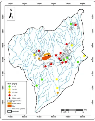
Figure 7: Spatial variation in nitrate concentrations (mg/l) of groundwater in the province Jerada (dry season)
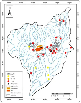
Figure 8: Spatial variation of nitrate (mg/l) of groundwater in the province Jerada (wet season)
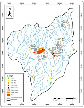
On chloride contents of groundwater in the province Jerada of the 35 wells tested in wet season, 77% of samples exceeded the WHO guidelines (125mg/l) with mean concentrations of the order of 254 mg/l. The interaction of groundwater with salt-rich marine deposits in the region could explain the high levels of chlorides in the water, a phenomenon much more pronounced during the wet season than in the dry season due to precipitation (Fig. 9 and 10).
Figure 9: Spatial variation of chloride contents (mg/l) of groundwater in the province Jerada (dry season)
Figure 10: Spatial variation of chloride contents (mg/l) of groundwater in the province Jerada (wet season)
IV. Conclusion
The results of physico-chmiques analysis of groundwater level in the province of Jerada reveal two main sources of pollution: a strong mining pollution is mainly reflected by very high concentrations of sulphate SO4
2-andnitrate NO3- pollutionlevelswhichare also veryimportant .Indeed coal mining produced large volumes of
waste consisting mainly of sulphide minerals with low economic value (pyrite and pyrrhotite). Conventional methods of disposal used in the majority of these operations expose rich residues sulfides to atmospheric oxygen causing their oxidation and liberation, therefore, H+ ions sulfates, iron and other metals. These effluents can migrate from storage areas and reach adjacent aquifers through leaching and / or percolation, thus affecting the quality of groundwater. Controling the generation of mine drainage means eliminating or reducing at least one of the three factors for its production: the contribution of water, oxygen diffusion and availability of sulphides. One way to prevent drainage of tailings containing sulphides is to cover the tailings with a material having a low permeability or overwhelm residues, which reduces the diffusion of oxygen into the tailings. The wealth of some minerals constituting the mining waste could also be used to re-use, in effect choosing the appropriate option for remediation is driven by several economic and environmental factors. The contents of NO3-are also important in the region, they are mainly due to a failure in the system of sewage and solid waste management. The introduction of a treatment plant wastewater and the establishment of a landfill would alleviate this problem.
Acknowledgement
References
[1] Amharref, M. ; Assine, S. ; Bernoussi, A. ; et Haddouchi, B., (2007). Cartographie de la vulnérabilité des eaux souterraines :
application au cas de la plaine du Gharb. Revue des Sciences de l'Eau 20 (2), 185-199.
[2] Bell, S.E.T. ; Bullock, T.F.J. ; Halbich, P. ; Lindsay, (2001). Environmental impacts associated with an abandoned mine in the Witbank
Coalfield, South Africa. International Journal of Coal Geology., 45, 195–216.
[3] Bendra, B.; Sbaa, M.; Fetouani, S.; Aleya, L., (2011). Assessing the impact of waste rocks on groundwater quality in the abandoned
coal mine of Jerada city (North eastern Morocco). International Journal of Engineering Science and Technology., 10 (20), 1-5.
[4] Benzaazoua, M. ; Bernier, L. ;Bussière, B. ; Plante, B. ; Villeneuve, M. (2002). Rapport d’avancement du projet 2.3.1 : « Prédiction du
DMA pour la sélection des modes de restauration ».Essais de prédiction du DMA : revue de littérature sur les essais statiques et cinétiques. Chaire CRSNG Polytechnique – UQAT en environnement et gestion des rejets miniers, 3/51p.
[5] Bussière, B .Aubertin, M. Zagury, G,J. Potvin, R . Benzazoua,M .(2005). Principaux défis et pistes de solution pour la restauration des
aires d’entreposage de rejets miniers abandonnées. Symposium 2005 sur l’environnement et les mines, Rouyne Noranda.
[6] Chellai, H.Essamoud ,R. Rjimati, E.C. (2011). Les principales mines du Maroc: Les mines du moyen Atlas et des Horsts; le basin
houiller de Jerada. Notes et memoires du service géologique du Maroc, N°564, 9, 20-25.
[7] Darmane, Y.; Alaoui, A.; Kitane, S.; Bennajah, M.; Daramy, A.; Cherkaoui, M., (2009). Recycling the slagheap of an old coal mine
(morocco). Separation and Purification Technology., 68, 125-128.
[8] Desteucq, C., (1982). Synthèse sur le Carbonifère du Maroc oriental : essai de reconstitution paléogéographique. Rapport
interne DES. 69.55 p.
[9] Desteucq, C. ; lzart, A. ; Potherat, P., (1988). Etude sédimentologique du Carbonifere du Bassin de Jerada (Maroc oriental), Ann.
Sot. Géol. Nerd. CVII. 203-210.
[10] Essadek, A.,(2004 ) : A coup de croissance et sous équipement d’une ville minière marocaine. Recensements de 1982 à1994 .mémoire
DEA.
[11] Espana, J.S. ; Pamo, E.L. ; Pastor, E.S. ; Ercilla, M.D., (2006). The acidic mine pitlakes of the Iberian Pyrite Belt: An approach to
theirphysicallimnology and hydrogeochemistry. Ap. Geochem. 23, 1260-1287.
[12] Essamoud, R. ; Courel, L.,(1996). Le Houiller productif (Westphalien C) du bassin de Jerada (Maroc oriental) : données
sédimentologiques, in J3ème Col. Bas. Séd. Fac. SC. Semlalia.110.
[13] Gairoard,S.,(2009). Contribution à l’étude de l’impact des anciens travaux miniers de charbon sur les eaux souterraines : Application à
la region d’Ales(GARD). Thèse de doctorat préparée à l’Ecole des Mines, Génie Civil – Hydrosystèmes – Géotechnique.pp32-34.
[14] Gisbert,C. ; Ros, R. ;DeHaro,A. ;Walker, D.J. ;Bernal, M.P. ; Serrano, R., Navarro,A.,(2003). A plant genetically modified that
accumulates Pb is especially promising forphytoremediation. Biochemical and Biophysical ResearchCommunications, 303, 440-445.
[15] Govil, P.K.; Reddy, G.L.N.; Krishna A.K., (2001). Contamination of soil due to heavy metalsin the Patancheru industrial development
area, Andhra Pradesh, India. EnvironmentalGeology, 41, 461-469.
[16] Gunsinger, M.R. ; Ptacek, C.J. ; Blowes, D.W. ; Jambor ,J.L., (2006b). Evaluation of long-termsulfide oxydation processeswithin
pyrrhotite-richtailing, Lynnn Lake, Manotoba. Journal of Contaminant Hydrology, 83, 149-170.
[17] Lzart, A., (1990). Dynamique des corps sédimentaires clastiques dons les bassins carbonifères de la Meseta marocaine, Mém.
d’habilitation, Université de Bourgogne, consultable à l’université de Bourgogne. Dijon. 357 p.
[18] Lzart, A., (1991). Les bassins carboniferes de la Meseta marocaine. étude sédimentologique et approche structurale. Part de la
tectonique et de I’eustatisme, Rev. GBol. mbditerr, XVIII, 61-72.
[19] Kleinmann, R.L.P. ; Crerar, D.A. ; Pacellil, R.R., (1981). biogeochemistry of acid mine drainage and a method to control acid
formation. mining engineering, pp. 300-304.
[20] Krimissa, S. ; Michelot, J-L. ; Bouchaou, L. ; Mudry, J. ; Hsissou, Y.,(2004). Sur l'origine par altération du substratum schisteux de la
minéralisation chlorurée des eaux d'une nappe côtière sous climat semi-aride (Chtouka-Massa, Maroc). Comptes Rendus Géosciences. Volume 336, Issue 15.Novembre 2004, Pages 1363-1369.
[21] Lappako, K., (1990). Regulatory mine wastecharacterization: aparallel to economicresource evaluation. Western Regional Symposium
on Mining and MineralProcessingWastes. May 30-June 1, 1990, University of CA at Berkeley. 31-39.
[22] Lei, L. ; Song, C. ; Xie, X. ; Li, Y. ; Wang, F., (2010). Acid mine drainage and heavymetal contamination in groundwater of
metalsulfide mine ataridterritory (BS mine, Western Australia. Trans. Nonferrous Met. Soc. China 20, 1488-1493.
[23] McKee, J.E.; Wolf, H.W.,(1963). Water quality criteria. 2e edition. California State Water Quality Control Board, Sacramento, CA.
[24] Moroccan ministry of agriculture, rural development, water and forests, 1996. Rapport d’activité. 40p.
[25] Moroccan ministry for energies and mines,( 2008) Department of Energyand Mines. Managementof mining development. «Le
secteurminierdans la Région de l’oriental ». 235-246pp.
[26] Office National de l’Electricité, (2007).Rapport d’actualisation.Actualisation de l’étuded’impactsurl’environnement du projet de la
centrale thermo-solaired’AinBeniMathar,
[27] Owodenko, B., (1976). Le bassin houiller de Jérada (Maroc oriental). Essai de synthèse et de paléogéographie. Notes Mém.
Serv. Géol. Maroc. 207 bis, 148 p.
[28] Raynal, R.,(1961). Plaines et piémonts du basin de la Moulouya (Maroc oriental). Etude géomorphologique. Thèse lettres. Paris.
Faculté des lettres. Rabat. 573p.
[29] Ruellan A., (1971). Contribution à la connaissance des sols des régions méditerranéennes : les sols à profil calcaire différencié des
plaines de la basse Moulouya (Maroc Oriental). Mém.O.R.S.T.O.M. Paris, n°54.
[30] Shen ,JF.; Li, SR.; Sun, DS.. Li, GH., (2004) Study on desertificated soil rehabilitation by solid wastes-a case study in Baotou, Inn
Mongolia, China. Soil Bull 35(3):267–270 (in Chinese with English abstract)
[31] SRK (Steffen, Robertson, Kirsten)., (1989). Draft acid Rock Technical Guide. BC AMD Task Force, Vancouver, Canada.
[32] Thauvin,J.P., (1969).Bibliographie hydrogéologique analytique du Maroc 1958-1968 / par Michel Combe et Jean-Pierre Thauvin :
Ministère des travaux publics et des communications, Direction de l'hydraulique, Division des ressources en eau ,
[33] Wakida, F.T.; Lerner, D.N., (2005) Non-agricultural sources of groundwater nitrate: a review and a case study. Water research 39:
3-16.
[34] Zis, T. ; Ronningen, V. ; Scrosati, R.,(2004). Minorimprovement for intertidal seaweeds and invertebratesafteracid mine drainage
diversion atBritannia Beach, Pacifie Canada. Mar. Pollut. Bull. 48, 1040-1047.