Vol. 2(10), 2010, 5621-5625
Spatial Data Mining Using Novel Neural
Networks for Soil Image Classification and
Processing
S.Nagaprasad 1*Research Scholar, Dept. of CSE, Aacharya Nagarjuna University, Guntur,
Dr.A.VinayaBabu
Professor, Dept. of CSE,
JNTU College of Engineering, Hyderabad,
K.Madhukar
Professor Nizam College, Osmania University, Hyderabad
D.Marlene Grace Verghese
Associate Professor in MCA
Bhimavaram Institute of Engineering & Technology Pennada, West Godavari
V.Mallaiah
Research Scholar, Dept. of CSE, Aacharya Nagarjuna University, Guntur,
A.Sreelatha
Student, Dept. of CSE,
JITS College of Engineering, Karimnagar,
A.Pratima
Dept of Computer Science,
Nizam College, Osmania University, Hyderabad
Abstract:
The emergent field of spatial data mining uses spatial dependency that is prevalent on spatial data sets, which can be modeled and incorporated into data mining process. Spatial relations are modeled during a data pre-processing step, consisting of the density analysis and vertical view approach, after which an exploration with visual data mining follows. In this paper we implemented, spatial image processing mining for soil classification using diversified domains like Digital Image Processing, Neural Networks, and Soil fundamentals. The three most important algorithms used in implementation are Back Propagation Network (BPN), Adaptive Resonance Theory 1 (ART) and Simplified Fuzzy ARTMAP for soil classification as well as spatial image recognition. Further we are working on our research by combining the visual data mining with spatial data mining algorithms, such as spatial clustering, spatial association rules, a self-organizing map etc. in order to try to detect patterns in the data in an even more effective way.
Keywords: Spatial Data Mining, Neural Networks, Soil Image Classifications, Scientific Data Mining
I Introduction:
systems like Geographic Information Systems (GIS) etc. Because of the events such as the scheduled launch of more satellites, it is widely expected that the amount of spatial data collected will soon be so enormous that it becomes unrealistic for human users to examine the data in detail. Spatial Data mining aims to automate as much as possible, the task of extracting interesting information from the spatial data. It presents new challenges due to the large size of spatial data, the complexity of spatial data types and the spatial data types and the special nature of spatial access methods. Most research in this area has focused on efficient processing of static data, like remote sensed image. We introduce an active spatial data mining approach that extends the current spatial data mining algorithms to efficiently support user defined processing on dynamically evolving spatial data.
In this paper we implemented, spatial image processing mining for soil classification using diversified domains like Digital Image Processing, Neural Networks, and Soil fundamentals. The three most important algorithms used in implementation are BPN, ART1 and Simplified Fuzzy ARTMAP for soil classification as well as spatial image recognition.
II Overview of Spatial Data Mining for Remote Sensed Data:
Spatial Data Mining means extracting undiscovered and implied spatial information, such as spatial patterns, which is not visibly stored in a spatial database [1-4].Spatial pattern matching is a process, where actual spatial data stored in a spatial database is extracted, analyzes and matches of a specific pattern or type of data specified by a user is generated. Application areas of Spatial data mining for discovering unexplored information such as patterns, clusters and clusters from spatial databases includes: Geography, Geology, Medical Imaging, Robotics, Video Processing, Navigation, Traffic Control etc. Geographical and geological data mining is a subset or part of spatial data mining. Geographical data mining is to mine geographic data such as maps. It is the process of exploring necessary and earlier unknown information from large spatial databases. The distinguished characteristic of spatial data mining can be neatly summarized by the first law of geography: All things are related, but nearby things are more related than distant things. The implication of this statement is that the standard assumption of independence and identically distributed (IID) random variables, which characterize classical data mining, is not applicable for the mining of spatial data. Spatial statisticians have coined the word spatial-autocorrelation to capture this property of spatial data. The important techniques in data mining are association rules, clustering, classification, and regression. Each of these techniques has to be modified before it can be used to mine spatial data. In general there are two strategies available to modify data mining which is based on the IID assumption, can be corrected, or the objective function, which drives the search, can be modified to include a spatial term.
III Neural Networks in Spatial Data Mining:
Neural networks offer a mathematical model that attempts to mimic the human brain. The network is composed of a large number of highly interconnected processing elements (neurons) working in parallel to solve a specific problem. Neural networks learn by example. They cannot be programmed to perform a specific task. [9-11]. Back propagation learning is used to train feed-forward networks. For each training instance, back propagation works first by feeding the instance through the network and computing the network value. To compute the one output value is computed for each output layer node. Many important advances have been boosted by the use of inexpensive computer emulations. Following an initial period of enthusiasm, the field survived a period of frustration and disrepute. During this period when funding and professional support was minimal, important advances were made by relatively few researchers. These pioneers were able to develop convincing technology which surpassed the limitations identified by Minsky and Paper. Minsky and Paper, published a book (in 1969) in which they summed up a general feeling of frustration (against neural networks) among researchers, and was thus accepted by most without further analysis. Currently, the neural network field enjoys a resurgence of interest and a corresponding increase in funding.
IV Remote Sensed Image Classification and Processing:
Vol. 2(10), 2010, 5621-5625
The approach used in enhancing image data often depends on the type of enhancement required. Usually, it is necessary to use more than one method or try several different parameter settings in an algorithm before finding a combination which works well. If the algorithm and the parameter settings are not chosen with care, the image enhancement algorithm may result in a poorer quality image than the original. In some cases, for example in demising, it might not be possible to reduce the noise without adversely affecting the signal. This makes image enhancement one of the more difficult steps to automate in the scientific data mining process.
Digital image processing is an area characterized by the need for extensive experimental work to establish the viability of proposed solutions to given problem. Here in this paper image processing plays a vital role for interpreting the remote sensed data. Remote sensing is the small or large-scale acquisition of information of an object or phenomenon, by the use of either recording or real-time sensing device(s) that are wireless, or not in physical or intimate contact with the object (such as by way of aircraft, spacecraft, satellite, buoy, or ship). The digital processing has the following broad operations: Image rectification and restoration; Image enhancement; Image classification; Data merging and GIS integration. So it is mandatory that these operations are analyzed and interpreted with image processing tools i.e. various filter techniques. Depending upon application required, the needed filtering techniques are used. A large number of commercial and open source applications exist to process remote sensing data. According to an NOAA Sponsored Research by Global Marketing Insights, Inc. the most used applications among Asian academic groups involved in remote sensing are as follows: ESRI 30%; ERDAS IMAGINE 25%; ITT Visual Information Solutions ENVI 17%; MapInfo 17%; ERM appear 11%. In this paper it was focused on soil classification of various fields on the earth map/remote sensed image. Generally classification can be done with aid of various filter techniques but in order to classify the soils we are using an advanced platform called Neural Networks.
V Implementation and Validation:
Soil Functionality and Importance: Soil is different things to different people. To most of us it is something to be washed from clothes and swept out the door. To the geologist soil is the unconsolidated, weathered part of the earth's mantle, an insignificant, small fraction of its total volume. To the civil engineer it is the medium for the support of structures and a construction material. But to the agriculturist, soil is that part of the earth's crust in which the roots of plants grow. It is a vital, living component of the environment–a component that can be manipulated to affect crop performance. When soil is misused, crops become less productive; when handled with due consideration for its biological and physical nature, it can continue to yield crops throughout countless generations of cultivation and use.
Soil has three primary functions in sustaining plant life: It supplies mineral elements, serving both as a medium of exchange and as a place of storage; It supplies water and serves as a storage reservoir; It serves as a medium within which the roots of terrestrial plants, as well as those of many aquatic plants, anchor themselves.
Soil Systems: For the purposes of crop production, soil must be considered to be a delicate balance of interwoven and interacting systems: Inorganic minerals; Organic matter; Soil organisms; Soil atmosphere; soil water. The inorganic constituents of the soil-soil minerals are ultimately derived from the parent materials, which are underlying chemically weathered minerals or organic matter that is the basis of soil. Soil minerals may be original, relatively unchanged from the parent minerals (such as quartz in the form of sand), or secondary, formed by the weathering of less resistant minerals (such as clays)
TABLE 1: CLASSIFICATION OF SOIL PARTICLES*
Particle Diameter (mm)
Coarse sand 0.5-1
Medium sand 0.25-0.5
Fine sand 0.1-0.25
Very fine sand 0.05-0.1
Silt 0.002-0.05
Clay <0.002
*The International Classification (Atterberg) System refers only to
soil particles under 2 mm:
Coarse sand 0.2-2 mm
Fine sand 0.02-0.2
Silt 0.002-0.02
Clay <0.002
TABLE 2. REFERENCE DATA (SAMPLE TRAINING) FOR SOIL CLASSIFICATION.
Color of soil
(Gravel %) 18
(Sand %) 82
(Fine grained particles %) 84
(liquid limit % ) 59
(plastic limit %) 34
I.S Classification
0.1 0 0.304 0.892 0.728 0.754 0.204(0.2)
0.1 0 0.951 0.261 0.627 0.676 0.0912(0.1)
0.2 0.222 0.658 0.5 0.525 0529 0.0887(0.1)
0.2 0 0.536 0.666 0.576 0.647 0.292(0.3)
0.5 0 0.597 0.607 0.61 0.0823 0.592(0.6)
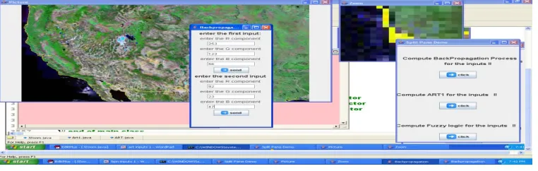
The main ones are sand, salt, clay, and loam. The non technical terms "lightness" and heaviness" refer to soil texture. "Heavy soils" are high in clay and other fine particles; "light soils" are low in clay and high in sand and other coarse particles. Steps involved in completion of the implementation: Loading the image: First, Initially we load an image into a swing frame using “Buffered Reader” class. Second, Zooming the Image: The next step is to zoom the image, for this creating a separate zoom frame for the zooming of the image at the desired location, selecting the part of the image into a zoom frame at zooming the part to the desired value. Third, Finding the RGB and Intensity values: From the zoom frame locating the desired point in the image, finding the RGB values at that point, intensity values as well. Fourth, computing the inputs to the Algorithms: The calculated RGB values are given as inputs for the Algorithms for the commutations, for the inputs creating a separate frame, and giving inputs. Finally, Execution: The final procedure is to execute the algorithms with the input values given, displaying the outputs. Refer to Table 2 which consists of Sample training data for soil classification. Refer to Figure1, which consist of Back Propagation Network Input Processing Screen shot.
Vol. 2(10), 2010, 5621-5625
VI CONCLUSIONS:
In this paper we implemented, spatial image processing mining for soil classification using diversified domains like Digital Image Processing, Neural Networks, and Soil fundamentals. The three most important algorithms used in implementation are BPN, ART1 and Simplified Fuzzy ARTMAP for soil classification as well as spatial image recognition. Further work includes, opportunities in dealing with the size of scientific data sets, the advent of new computer architectures, the analysis of new types of data, the need to analyze streaming data in real time, the analysis of geographically distributed data, the need to draw conclusions in the presence of uncertainty, multistage analysis etc.
VII References:
[1]. Chandrika Kamath: Scientific Data Mining A Practical Perspective. Society for Industrial and Applied Mathematics, Philadelphia (2009)
[2]. Andreas Riedl, Wolf Kainz, Gregory A.Elmes. Progress in Spatial Data Handling. 12Th International Symposium on Spatial Data Handling.
Springer-Verlag Berlin Heidelberg. (2006)
[3]. Boric Kovalerchuk, James Schwing: Visual and Spatial Analysis. Advances in Data Mining, Reasoning and Problem Solving. Springer, U.S.A ISBN 1-4020-2939-X (HB) (2004)
[4]. Shashi Shekar, Sanjay Chawla. Spatial Databases A Tour. Prentice Hall Upper Saddle River NJ U.S.A. (2003)
[5]. Bernd Jahne: Practical Handbook on Image Processing for Scientific and Technical Applications Second Edition University of Heidelberg, CRC Press (2004)
[6]. Robert A.Schowengerdt. Remote Sensing Models and Methods for Image Processing Second Edition. Elsevier Academic Press. (1997) [7]. Andrian Low. Introductory Computer Vision Imaging Techniques and Solutions. Second Edition. Adrian Andrew Low, McGraw-Hill Inc. USA. (2008)
[8]. Arthur R.Weeks, Jr. Fundamentals of Electronic Image Processing. Society of Photo-Optical Instrumentations Engineers, USA (1999) [9]. Da Raun, Guoquing Chen, Etienne E.Kerre, Geert Wets (Eds.). Intelligent Data Mining Techniques and Applications. Springer Kluwer Academics Publishers (2001)
[10]. Earl Cox. Fuzzy Modeling and Genetic Algorithms for Data Mining and Exploration. Elsevier Morgan Kaufmann (2005) [11]. Ian H.Witten, Eibe Frank. Data Mining Practical Machine Learning Tools and Techniques Second Edition. Elsevier Morgan Kauffman (2005)
S.Nagaprasad Received the Bachelor of Computer Applications (B.C.A.) From Osmania University, Hyderabad, in 2001, M.Sc (I.T.) From Sikkim Manipal University, Manipal in 2003 and M.Tech (C.S.) From Allahabad Agricultural University, Allahabad in 2005. Presently Pursing Ph.D in Computer Science & Engineering from Aacharya Nagarjuna University, Guntur.
Prof.A.Vinay Babu obtained his Bachelors degree in Electronics & Communication Engineering from Osmania University. Has duel Masters Degree, one in Computer Science & Engg and the other one is in ECE from JNTU. He obtained his PhD from JNTU, Hyderabad. His research area is Data Mining and Image processing.