EXCAVATIONS AT NEMEA, 1976
(PLATES 1-16)
EXCAVATIONS
were continued in 1976 at Nemea' in the Sanctuary of Zeusand in the Stadium (Fig. 1).2 Due to property limitations no work took place on Tsoungiza.
THE SANCTUARY
Excavations were concentrated in that part of the sanctuary which lies south of the Temple of Zeus. The goal of these excavation-s was to reveal the topo- graphical nature of this area by means of a north-south cross section, and con- siderable progress toward this goal can be reported. Inasmuch as some of the adjacent 20 meter grid squares which were opened in 1976 clearly are parts of the same topographical units, reports of some grid squares will be combined.
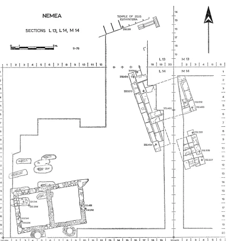
Sections L 13, L 14, and M 14
Situated alongside the eastern part of the south side of the Temple of Zeus (Fig. 2), this area is littered with fallen debris of the temple. Indeed, six column drums and one capital were moved in order to clear the northeast corner of Section L 14 and the narrow strip of L 13 up to the temple itself (Fig. 3).
The southwest corner of L 14 revealed the most substantial evidence for By- zantine activity as yet discovered at Nemea. This was in the form of a two-room structure complete with stone-and-cement paving and with two very well constructed cisterns along its south side (Fig. 3, P1. 1 :a). Measuring about 5.20 X 8.20 m.,
I The staff consisted of Glenn Markoe, Barbara McLauchlin, Helena Miller, Nancy Tersini-
all of Berkeley-and David Romano of the University of Pennsylvania as field archaeologists; Irina Barnes, Linda Lux, and Lynda Mancebo of Berkeley as museum technicians; Stephen Elbert as photographer and architect; and Professor Stella G. Miller as Assistant Director. The hard and careful work of these people has contributed greatly to the progress of the Nemea excavation and has earned the gratitude of the undersigned.
We would also express thankfulness to the many institutions and individuals who have aided us in 1976. Particular mention should be made of the American School of Classical Studies and of its Director, Professor J. R. McCredie, of the Greek Archaeological Service and of its Inspector- General, D. Lazarides, and of the Ephorea of Classical Antiquities at Nauplion and of its Ephor, Mrs. E. Deilaki. The constant support of the University of California at Berkeley and of its Chancellor, A. H. Bowker, has continued to play a crucial role for Nemea.
Our sincere gratitude also goes to the National Endowment for the Humanities for a gift- and-matching grant which has supported the operating expenses of the 1976 campaign. We are equally indebted to the more than 100 private donors whose contributions have made the afore- mentioned grant, and thus the 1976 season, possible. Although we cannot mention all their names here, we hope that each donor will understand the extent of our gratitude.
2 For previous work at Nemea see S. G. Miller, "Excavations at Nemea 1973-1974," Hesperia
44, 1975, pp. 144-172, and idem, "Excavations at Nemea, 1975.," 45, 1976, pp. 174-202.
Hesperia, 46, 1.
American School of Classical Studies at Athens is collaborating with JSTOR to digitize, preserve, and extend access to
Hesperia
STEPHEN G. MILLER
<4 in Vt 10 N C9 CM, m- -o' o
"IN
CA !,W
tD to
cn
14-01
1.4
ZZZZ--
... . . ....
OD to
EXCAVATIONS AT NEMEA, 1976 3
this structure was built of blocks from the Temple of Zeus, which were set at intervals with smaller stones between. Ceramic material found in the western cistern and beneath the floor ' indicates both a construction date and a filling date within the 13th century after Christ. This evidence may, however, be misleading, for a bronze earring (GJ 11; P1. 1:b), although found about a meter north of the north wall and thus outside the building, was some 0.32 m. below the level of the structure's floor and appears to be later than the date suggested above for the structure. The fill beneath the floor did produce a lamp (L 20; P1. 1:c) which, although too early to aid in the question of the date of the structure, accurately foreshadowed the discovery of activity of the 5th and 6th centuries after Christ in this area.
As has been noted frequently throughout the sanctuary, farming activities of the early Christian period were extensive at Nemea. The eastern part of Section M 14 proved to be no exception, for the farming noted in M 13 during 1975 was found to continue southward (P1. 1 :d). The shallow rectangular farming pits which have become all too familiar at Nemea did not, however, continue further west. A part of the reason for their absence became apparent in the western part of L 14 where an early Christian cemetery was discovered (Fig. 3, Pls. 1 :e, 2:a). Although this cemetery may continue to the west, a total of nine graves was excavated in L 14, and four of these were located beneath the building described above. All were cut through the hard, Early Hellenistic, plateia surfacing (see below) which accounts for their crisp outline. Eight of the graves were simple cist burials with Lakonian-type tiles used as side walls, and smaller tiles of the same type used as covers for the tombs. The ninth tomb, at the southwest corner of the group (area L/2, 3-14/16; cf. P1. 2:a), was completely constructed of stone (mostly re-used stele bases) and was covered by stone slabs. It was, however, a cenotaph containing neither artifacts nor skeletal remains. Indeed, none of the graves contained any material other than skeletal and they cannot be dated archaeologically. Since, however, the graves respect the fallen blocks of the temple, they should be later than the proposed destruction of that building in ca. A.D. 370.4 Furthermore, it has become
clear that, after the destruction of a fairly extensive settlement at Nemea in the later 6th century after Christ, there is no evidence of human activity until the 12th century. Thus, the cemetery is almost certainly to be dated to the 5th or 6th century after Christ.
A small amount of additional evidence for the destruction date of the Temple of Zeus emerged from beneath the column drums which were removed from L 13 (cf. Fig. 3). The fill here contained several Archaic and Classical ceramic f rag- ments, but is to be dated to the mid-3rd century after Christ in view of pottery and lamp fragments from the first half of that century.5 This at least does not contra- dict the suggested later-4th century date for the destruction of the temple.
3 Pottery lots L 14: 9 and 8, respectively.
4 STEPHEN G. MILLER
4a-~~~~ 1- 0 0
0
.,0 . ._ . _ _ _ _ . _ _ _ _
ol IL lW?L f
2 0
z
0.~~~~~~~~~~
0 . .. ... ... . , , - W ... ... ot r ool : h
-IIz iISt
k I M* 0 - I
Il I t \ : 1
(9 se)t
EXCAVATIONS AT NEMEA, 1976 5
NEMEA TEMPLE OF ZEUS
EUTHYNTERIA 15
SECTIONS L 13, L 14, M 14
17
18
9-76
19
L13 M 13 2
2 3 | 4 1 5 1 6 | 7 | 8 1 9 | 10 I 11 12 16 1 9 1 20 1 2 | 3 1 4 1 51 6 |
1 L 14 M 14 1
332A3.348
2 .-- '2
3 3< t 3 2
332.672 -
4 ..4
5 ~~~~~~~~~~~~~~~~~~~~~~~~~~~~~~~~~ 32.460
313.480 332.460
61 .= .- 6
7 7
8 . .
W 32.501
9 \-9
332.44
10 332535- 10
11 tX2.3 11
-2= -A3t \ / 332227 -
12 12
13 S 94X|13
i'2'91 t;t 2314 B 140 i 1
15 |5 2|
FIG. 3. SeCtiO L 13, L 14, M 14.16
17 ~~~~~~~~~~~~~~~~~~~~~~~~~~~~~~~~~~~~~~~~~~~~~~~~~~17
18~~~~~~~~~~~~~~~~~~~~~~~~~~~~~~~~~~~~~~~~~~~~~~~1
20 ~~~~~~~~~~~~~~~~~~~~~~~~~~~~~~~~~~~~~20
3329311 314 1 5 61718 19 901111 12/13 114 115/16 117 1is8I19 1 333.470j2j1 31415I1 C
6 STEPHEN G. MILLER
If the Byzantine and Early Christian activities in this area were not so destructive as elsewhere in the sanctuary, they seem still to have been responsible for a certain amount of damage. A large blue-black marble perirrhanterion (A 97; P1. 2 :b,
cf. P1. 1 :d), found near the north side of M 14 and just west of the farming pits, was badly battered. Even more battered are the many fragments of inscriptions from these stratigraphic contexts. While a few of these such as I 19 (P1. 2 :c) and I 26 (Pl. 2,:d) appear to come from different texts, several groups can also be discerned which almost certainly came originally from the same stone, although they do not now physically join. Such groups are I 20 (P1. 2:e), I21, 122, I23 (PI. 2:f), I 24, I 25, and I 27; I 16 (Pl. 2:i) and I 17; I 28 (Pl. 2:h), I 29 (Pl. 2:g), and I 30. This destruction is further attested in these same contexts by the appearance of many fragments of bronze sculpture of which a small sample is shown here (BR 54, BR 58, BR 60, BR 64, BR 67, BR 86, BR 141, BR 147, BR 148; P1. 3:a). While most of these can be attributed only to a general part of a statue, one piece is clearly from a lock of hair (BR 180; P1. 3:b). A series of bronze olive leaves (BR 66, BR 109, BR 139, BR 184; P1. 3 :c) probably once adorned such a statue. Also from Byzantine contexts came a bronze implement of a type sometimes called an earspoon (BR 149; P1. 3:d).a
With the removal of this deblris and the cleaning of the Early Christian graves and farming pits, nearly all of Sections L 14 and M 14 revealed a hard, white, con- crete-like paving for an open square or plateia. This paving would appear to postdate slightly the construction of the Temple of Zeus; indeed, it consists largely of working chips, fist-sized stones, and other lithic material which has slightly decomposed, all solidified into a hard mass. Toward the north of Sections L 14 and M 14 an interesting group of structures was discovered, although they are still partially covered by the two-meter baulk between the two sections (Fig. 3, P1. 3 :e).
The southernmost of these structures is almost completely exposed and lies wholly in Section M 14. It consists of a rectangular foundation platform about 2.50 X 3.75 m. in size which is made up of eight soft yellow poros blocks, each measuring about 0.65 X 1.25 m., and of a row of four smaller blocks along the south side. While the two central blocks of the latter four are also of soft yellow poros, the blocks at the southwest and southeast corners of the structure are of hard gray limestone and thus represent a reinforcing of the cornerstones which faced out onto the plateia. Three gray limestone blocks survive of the first course above the foundations. One of these is a thin block, measuring some 0.30 X 1.10 m., apparently still in situ at the center of the south side; the other two are larger blocks measuring about 0.65 X 1.20 m. and are definitely in situ along the east side. All of these blocks are battered; it is difficult to restore any further elements and thus to interpret the function of this structure. Perhaps the most likely would be as a base for a large sculptural group.
EXCAVATIONS AT NEMEA, 1976 7
Along the north side of the structure near its east end a gray limestone block, measuring 0.56 X 0.74 m., was set sometime after the original construction. The purpose of this block is unknown as are the precise dates of its setting and of the construction of the base as a whole. The test trenches to north and south of the base yielded no datable material associated with the construction levels,7 but the relation of the structure to the surface of the plateia makes a very late 4th century or early
3rd century B.C. date necessary.
To the north of this base lies another monument (henceforth to be called the "Nu Structure ") which is partly in L 14 and partly in M 14. Although it has a most peculiar form and is not completely uncovered, its outlines are essentially clear
(Fig. 3, P1. 3:e). Its exterior is completely enclosed by a euthynteria course ca. 0.50 m. high and of hard gray limestone. Behind this euthynteria is a core of soft yellow poros blocks. As revealed by a test trench to the south of the structure in M 14 (P1. 4:a), one of these euthynteria blocks is inscribed with a large "U; the whole course rests upon massive foundations consisting of three courses of soft yellow poros with a total depth of about 0.90 m. below the euthynteria. The blocks of the euthynteria average 0.60 X 1.20 m. in size and have no trace of clamps or dowels, but several preserve traces of a setting line (in one case two parallel lines less than 0.01 m. apart) which is set back an average of 0.10 m. from the front edges of the blocks. Where preserved, the soft yellow poros core blocks, which were originally at least 0.15 m. higher than the euthynteria, have also been cut back an average of 0.10 m. for the reception of the next course of exterior blocks. Not all the euthynteria blocks are neatly set, with the result that the preserved setting lines do not form a straight, continuous line. This fact may indicate that the " Nu Struc- ture," in its present form, is the result of the remodeling of an earlier structure. Such a history may also be indicated by the blocks at the northwest and southwest corners of the structure, both of which are set back ca. 0.15 m. from the line of the west face of the other euthynteria blocks (cf. P1. 4:d). The southwestern block projects some 0.39 m. to the south beyond the line of its eastern neighbor. The upper surface of its projection has been left rough with only the northern part of the block worked down to the level of the other euthynteria blocks. The northwestern block of the " Nu Structure " also projects, some 0.65 m. to the north beyond the line of its eastern neighbor. The upper surface of its projection has, however, been worked to the level of the other euthynteria blocks and contains two rough cuttings within a roughly square, weathered area as if for a statue base above. A further indication that the " Nu Structure " has undergone remodeling was revealed east of this projection where the poros foundations continue the northern line of this projecting euthynteria block eastward, with no structural purpose in the present arrangement.
Of all the pecularities of the " Nu Structure," the form is the most striking
8 STEPHEN G. MILLER
anrd a supposed remodeling cannot explain all of this, for even the original structure must have had the same general outlines. As it now stands, the basic form is that of a rectangle of some 4.40 X 6.30 m. with its long axis parallel to that of the Temple of Zeus. The plan is completed by wings, about 2.00 m. wide, projecting to north and south along the line of the back, or western, side of the structure. The northern wing extends about 1.50 m. to the north while the southern wing extends about 2.95 m. to the south (not including the additional projections of the northwest and southwest blocks as described above). The setting lines and, more conclusively, the cutback of the poros core blocks indicate that the next exterior course of the " Nu Structures" repeated this outline on a slightly smaller scale. The solid core and the massive foundations imply that a considerable weight was to be supported, but the nature of the higher architectural elements, and thus of the function of the " Nu Structure," remains obscure. One might think of a broad stairway leading up from the east to a long narrow altar platform, but other possi- bilities are not excluded.
A test trench between the " Nu Structure " and the monument to the south in M 14 (see p. 7 above) and another between the " Nu Structure " and the Temple of Zeus in L 13 failed to yield precise dating evidence. It is nonetheless clear, as implied by the parallel orientation of the " Nu Structure " and tlhe temple, that the former is, in its extant form, slightly later in date than the latter and ought most probably to be placed in the last quarter of the 4th century B.C.
The afore-mentioned test trenches, while not helpful in fixing the chronology of the new structures, did reveal several layers of activity going back into the early Archaic period. Artifacts which attest this include two pyxis lids (P 199, P1. 4:b; P 238, P1. 4:c), an aryballos (P 239, P1. 4 :f), two terracotta figurines (TC 50, P1. 4:e; TC 54, P1. 4:h), and a fragmentary antefix (AT 43, P1. 4:g).8 It is of interest that although the lowest Archaic levels contained a few Geometric sherds the next stratigraphic units lower down were exclusively Mycenaean in date.9 These 'earliest layers were directly above virgin soil. Thus, although some additional evidence of limited Geometric activity at Nemea has appeared, the general indications of previous years continue to be borne out: after a period of activity during the Late Bronze Age, the area of the Sanctury of Zeus sees very little use until that time in the Archaic period when Isthmia and Delphi, as well as Nemea, were becoming Panhellenic centers.
Evidence for activity of an unexpected type was also revealed. A test trench along the western side of M 14 (P1. 5 :a) produced many bronze arrowheads in a good stratigraphic context. One layer, in a trench measuring 1.50 X 7.00 m., yielded -no less than ten such arrowheads in addition to an object which may be a harness fitting (BR 163-BR 168, BR 175-BR 178, BR 217; P1. 5 :f). Found in association
6 Pottery lots M 14: 15, 17, 18, 30, 31; L 13: 11, 19, 20.
EXCAVATIONS AT NEMEA, 1976 9
with fragments of burnt limestone, there can be little doubt that this is evidence of violence and destruction in the sanctuary. The ceramic date for this layer belongs in the last half, and probably in the last quarter, of the 5th century B.C."
Sections M 15 and N 15
Section M 15 revealed a continuation of the concrete-like, wlhite plateia surface which had been discovered further north. Indeed, this broad open square extends throughout the whole of the section into N 15 with no permanent feature in sight (P1. 5 :c). The disturbed upper layers in both sections contained, nonetheless, material of interest such as iron spear points (IL 97, IL 99), a bronze pomegranate pin head (BR 52), a bronze disk with handle (BR 155), a bronze olive leaf which may well belong together with those from L 14 and M 14 (BR 157), and three bronze arrowheads (BR 47, BR 53, BR 156; P1. 5 :e).
Along the west side of Section M 15 the concrete-like plateia surfacing was found to have been pierced by three large pits (cf. Fig. 2, P1. 5 :c) containing car- bonized material and each more than 1.50 m. in diameter. The ceramic date for these pits in the first half of the 3rd century B.C." fits well with the idea that they were dug through the late 4th or very early 3rd century plateia surfacing. Among the material found in these pits was a large fragment of an antefix (AT 38, P1. 5 :d). A two-meter-wide test trench was excavated along the west side of Section M 15 in order to probe the earlier history of the plateia. The surface of the plateia itself was formed, as in M 14, of small fragments of limestone and poros which have, in effect, melted together. The ceramic date for the formation of this surface was clearly in the 4th century B.C.'2 and the most notable artifact was a bronze razor
(BR 220; P1. 5:b). Lower levels in this test trench included the same destruction layer previously noted in M 14. Once again, the evidence of turmoil in the form of bronze arrowheads (BR 162, BR 185, BR 221; P1. 6:a) was unmistakable, and once again the ceramically derived date for this event belongs in the second half of the 5th century B.c.'3
With the appearance of this evidence of violence throughout the southern part of the sanctuary and certainly within the limits of the sacred area, the obvious question emerges as to the precise nature and cause of the disruption. Ancient sources are silent about any battles or other violations of the Sanctuary of Nemean Zeus during this period, but there are two events implicit in the sources which might explain the evidence which is now coming to light. One of these events is the takeover of the sanctuary by Argos from Kleonai. Although this takeover is nowhere ex- plicitly mentioned in the extant testimonia, it must have occurred during the later 5th or the very early 4th century B.C. This emerges from the fact that, while the
10 Pottery lot M 14: 29.
Pottery lots M 15: 3-6.
10 STEPHEN G. MILLER
sanctuary is clearly under the control of Kleonai at least down to the 460's B.C.,'4 by
388 B.C. control of Nemea has passed to Argos."5 It may or may not be coincidence
that Euripides' Hypsipyle, probably first produced in 408 or 407 B.c.,18 provides a clear basis in (if not an appeal to) myth for the original Argive foundaticon of, and hence control over, the Nemean Games. It may be suggested then, although the evidence is obviously tenuous, that the Argive takeover of Nemea occurred during the Peloponnesian War and was carried out with a certain degree of force.17
The second possible occasion for the violence revealed by the 1976 excavations lies in the events of 388 B.C. when the Spartans marched through the Nemea valley from Phlious on their way to inflict a defeat upon the Argives.8 Although the
precise location of that battle is not stated by Xenophon, it was prefaced by an Argive attempt to misuse the Nemean truce and thus avoid the battle, and it might be the explanation for the destruction now attested. It should be remembered also that the general date for the disturbance in the Sanctuary of Zeus as revealed in 1976 is about the same as the date for the destruction of the earlier Temple of Zeus as revealed in 1974.19
Lower levels in the test trench along the west side of Section M 15 showed that the area had already been a nicely paved plateia in the Archaic period. Once again the lowest levels contained Geometric material, but no purely Geometric layer could be discerned.20
The 4th century concrete-like plateia surfacing of M 15 continues eastward into N 15 but about three meters into the latter section a subtle yet distinct change occurs along a north-south line. The hard surfacing gives way to well-packed clay which is cut by several large pits (P1. 6:b). Here, too, evidence of violence, although in a disturbed context, was found in the form of iron spear points (IL 65, IL 66) and a bronze arrowhead (BR 79; P1. 6 :c). Also from this context came a lead tablet which, when unrolled, revealed a curious inscription (IL90a-c; P1. 6:f):
1 Pindar, Nemean X. 42 (written for Theaios of Argos). For the date of this ode see C. M. Bowra, Pindar, Oxford 1964, p. 411. There are, however, arguments for a later dating to the period between 451 B.c. and Pindar's death; cf. U. v. Wilamowitz-Moellendorff, Pindaros, Berlin 1922, pp. 423-424. Argos had already claimed, but not won, control of Nemea in 468 B.c.; cf. Diodorus Siculus, XI. 65. 2.
15 Xenophon, Hellenica IV. 7. 2, where the Argives clearly have authority, if not propriety,
in declaring the Nemean truce.
16 G. W. Bond, Hypsipyle, Oxford 1963, p. 144.
17 Although no mention is made of violence at Nemea itself, one should note the extensive
Spartan military maneuvers against Argos in 418 B.C. There can be no doubt of a large military
presence at Nemea during that campaign; cf. Thucydides, V. 60. 3.
The often repeated statement by, inter alios, L. R. Farnell, Pindar II, London 1932, p. 317 that Argos gained control of Nemea in 460 B.c. is, to the best of my knowledge, based upon no ancient authority.
18 Xenophon, loc. cit.
EXCAVATIONS AT NEMEA, 1976 11 MYTONO 011Q 11-/ KAEONAI. The orthography of the inscription would indi-
cate a date no later than the 4th century B.C. (and possibly earlier) but the meaning of the tablet is elusive. The word MYTO NO, otherwise unattested, is probably to be taken as the genitive singular of a proper name followed by a number or a sum of money. Some sort of accounting is clearly intended but its precise significance, as well as that of the appearance of Kleonai, is unclear.
The series of pits in Section N 15 mentioned above became clear with the cleaning down to 4th century levels. These pits average about 2.00 m. in diameter and about 0.65 m. in depth. They were found to contain carbonized material some of which continued out through the sides of the pits in small and irregular tunnels. Most of the pits contained a small circular ring of stones forming a circular hole 0.10-0.15 m. in diameter. These holes contained very black carbonized material. The pits are arranged in three essentially parallel lines running from south-southeast to north- northwest in more or less the same orientation as the Temple of Zeus (cf. Fig. 2). Although the ceramic contents of some of the pits were earlier, it appears that all are to be dated to the second half of the 4th century B.C.2" A chemical analysis of carbonized material from these pits, although not available at this time, should clarify the purpose to which they were put. In the meantime, the suggestion can be made that these pits were the planting holes for a part of the grove of cypress trees which, according to Pausanias (II.15.2), surrounded the Temple of Zeus, with the temenos of Opheltes near by. In this context, a limestone pillar found in si'tu near the north scarp of N 15 (area N/14-15/2; cf. P1. 6:b) may be of significance. Measuring about 0.31 X 0.35 m., the pillar is broken at the top and does not now, if it ever did, have an inscription. Its general appearance and orientation (roughly that of the planting pits) might suggest, however, that it was a horos stone. A test trench to determine the date when this pillar was set in place yielded only a few battered Mycenaean sherds.22
Some five meters south of the pillar (area N/15-15/8) a large oval lekane was found embedded in the earth among the planting pits (P 219; Pl. 6:d, e). The function of this lekane is unknown althouglh its association with the sacred grove is clear.
An earlier layer in N 15 was probed and, once again, yielded evidence of violence in the second half of the 5th century B.C. (BR 77, BR 78, BR 113, IL 63, IL 70, IL 77; P1. 7:a).23 In addition to weapons, a fragment of a terracotta mold for bronze casting was found in this layer (TC 47; Pl. 7:a). The significance of this mold will become apparent below during the discussion of Section 0 16.
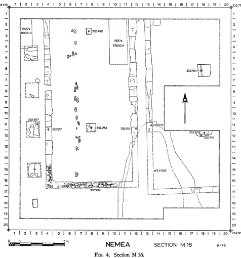
Sections L 16, M 16, M 17
The more recent intrusions in this area, aside from test trenches dug by the American excavators of the 1920's, were basically Byzantine with relatively little
12 STEPHEN G.. MILLER
.333-770 1 2 1 3 1 4, 1 6 6 1 7 1 8 1 9 f 10 j 11 j 12 j 13 14 f15 j186 17 118 f 1 j 20 "333.770 1
1~~~~~~~~~~~MtlV t$ vI,I I cC TMM "M"
2 1,~2
1920's 11AI
RNCHR,3249
3 3
r t~~~~~~~ 4 _~~~~~~~~~~~~~~~~~~~~~Z~ _ _ _ _ _ _ _ _ _ _
I D"
8
7 7~~~~27~3 511
13 13
12 12~~~~~~~~~~~~~'
-15
L?
i1
+331.662 \516 ~ ~ ~ ~ ~ ~--16
17 ~~~~~~~~ ~ ~~332.999
fL-1
~ ~19
1 19
20 2
12131415 16 1 71819 110111112113 114 11511r 117 16119 12034195
9.15m.
NEMEA SECTION MA 16 9-76
EXCAVATIONS AT NEMEA, 1976 13
evidence of Early Christian activities. In addition to a general Byzantine layer over the whole of the area, a very large and rather amorphous pit was uncovered in the southeast corner of M 16 and the northeast corner of M 17 (cf. Fig. 4). This pit pro- duced enormous quantities of middle Byzantine coarse ware and lesser amounts of fine ware.24 Among the latter were fragments of a sgraffito plate (P 166; P1. 7:b) and a small sgraffito bowl (P 164; P1. 7:e). The numismatic material included three coins of Manuel I (C 394, C 496, C 498; P1. 7:c), which securely place the deposit as a whole into the later 12th century after Christ.
Among the material from the upper levels of these sections mention may be made of yet another "earspoon" (BR 210; P1. 7:f) and of another lead tablet (IL 81; P1. 7:d). When unrolled the latter revealed the proper nouns TI Y PrAA I Q N KYKAIAE. This tablet, unlike that discovered in N 15, may then belong to the more common type of curse tablet.
Limitations of time prevented a full clearing of Section L 16, but enough work was done to establish the eastern limits of the third in a row of buildings which is emerging along the south side of the Sanctuary of Zeus (Fig. 2). Parts of three such buildings were discovered in 1975 within Section N 16, and parts of three others had already been found longer ago in our Sections K 16 and the western part of L 16.25 It is the east wall of the easternmost of the latter group which was found in L 16 in 1976. The soft yellow poros foundations of this wall have been badly dug through, almost certainly by Early Christian farming activities, and little trace remains of the south wall. The over-all dimensions of this building can, however, be established as roughly 7.20 X 16.50 m. While the side wall foundations are con- structed, as is usual in these buildings, of a single row of soft yellow poros blocks averaging 0.55 X 1.10 m. in dimensions, the north wall is constructed of a double row of such blocks with a total thickness of about 1.10-1.20 m. This should imply a massive north fa?ade wall facing out onto the plateia toward the temple. Although no information is available regarding the date of this building, it would appear to belong to the same general time as the others in this row.
About 0.75 m. east of the eastern wall of this third building is a poorly pre- served series of soft yellow poros blocks (P1. 7:g). These clusters of decomposed poros seem to be located about equidistant from one another at intervals of ca. 3.50 m. on centers, and they appear to align with a better preserved series of poros bases some 5.90 m. to the east in Section M 16 (Fig. 4, P1. 8 :a, b). Of the latter, the best preserved is the southernmost with dimensions of ca. 1.00 X 1.20 m. which may be close to the original measurements. The four bases in this row are also situated at intervals of about 3.50 m. on centers. Whether these two rows of bases are to be
24 Deposit M 16-17: 1; Pottery lots M 16: 4; M 17: 3-5.
25 The westernmost of these buildings, which is also the largest, was discovered in 1926;
14 STEPHEN G. MILLER
reconstructed as two free-standing but facing colonnades, or as the east and west ptera of a peripteral building, or as something else is not now obvious. For the moment they can only be grouped together as the fourth building in the row. The hard limestone block in the southwest corner of M 16 which falls into the same line as the eastern row of poros bases (see Fig. 4) may or may not belong to this building. The stratigraphic evidence for the southernmost poros base in M 16 indicates that it (and presumably its mates) was set in place during the first quarter of the 5th century B28
At a distance of only some 0.50 m. east of this row of bases lies the western wall of the fifth building in the row. The east-west outer dimension of this building is 8.30 m. and, although its north wall lies under the baulk between M 15 and M 16, its total north-south length can be estimated at about 15 meters. The state of preser- vation of this building varies dramatically. Its southeast corner has been totally destroyed by the Byzantine pit discussed above (as was the southwest corner of its eastern neighbor; Fig. 4, P1. 8:d), the foundations of the northern part of the west wall have been dug through by Early Christian farming, but the south wall and a part of the west wall still have the rubble socle preserved above the poros founda- tions. The latter consist of blocks averaging 0.60 X 1.20 m. in size. On the long axis of the building are hard limestone bases for two interior roof supports. These are of different sizes with the northern base measuring 0.50 X 0.55 m., the southern 0.75 X 0.85 m.; the distance between them (8.70 m. on centers) implies an inter- mediate base no trace of which has, however, been discovered. The southern wall has, on the long axis of the building, two re-used blocks which are larger than the usual rubble of the walls. One of these preserves a dowel cutting from its earlier use, the other a pair of ice-tong lifting holes. Cuttings for a door stop and a pivot hole show that these blocks were used here for the threshold of a single-leaf door about 0.95 m. wide. It is clear that this threshold represents a phase later than the original for the building, and the stratigraphy outside the building to the south suggests a date of the late 5th or very early 4th century for the placement of these blocks.27 The original construction date of the building appears to belong late in the first quarter of the 5th century B.c.28 The building was standing when pieces such as a tall trefoil oinochoe (P 189; P1. 8:c) were being used within the structure 29 and when a small votive deposit was made just outside the south wall (P 194-P 197;
P1. 9:a).Y
Unlike the other buildings in the row, this structure is provided with an additional accouterment in the form of a series of rough unworked stones which are placed in a north-south line about midway between the central interior bases and the west
26 Pottery lot M 16; 51. *27 Pottery lot M 16: 32. 28 Pottery lot M 16: 25.
29Cf. C. W. Blegen, H. Palmer, and R. S. Young, Corinth, XIII, The North Ceetery,
Princeton 1964, p. 133, D 49-f, pl. 57.
EXCAVATIONS AT NEMEA, 1976 15
I I 2 1 3 1 4 1 5 1 6 1 7 8 1 9 1 10 | 11 12 13 14 1 15 | 16 1 17 1 18 1| 20-
533 M4015 22
3 3
.4~~~~~~~~~~~~~~~~~~~~~~~~~~~
6 ~~~~~~~~~~~~~~~~~~~~~~~~~~6
332.021(I32.33201 S7386
416 M 8
17 ~~~~~~~~~~~~~~~3._312.943.5321
10 ~~~~~~~~~~~~~~~~~~~~~~~~~~~~~~~10
6:
t1 0 111
12
313 33227.640 13
-14 r. 1-4
5 | 2 1 43312 1.|12|18| | 6 | ? | | 9 | 0 | 1 1 2 3 1 2 15
'15~~~~~~~~~~~~~~~~~~~~~~~~~~~~~~~~~1
16~~~~~~~~~~~~~~~~~~~~~~~~~~~~~~~~~1
17
20 20
334.445-4 ---
2 2
3 ~ ~~~~~~~~~i-j
zj~PK <332.640 3
4 4
5
1 1 2 I 3 1 4 1 5 1 6 1 7 1 8 1 9 1 10 1111 12 13 1 14 1 15 16 1 17 1 18 1 19 1 20
NEMEA SECTIONS 0 15 & 0 17 9-76
16 STEPHEN G. MILLER
wall of the building (Fig. 4, P1. 8 :a). Seventeen of these stones still remain in place and each has a hole drilled through it in an east-west line perpendicular to the long axis of the building (P1. 9:b). A test trench revealed that these drilled stones are embedded in the floor and must have performed some function in association with the building. The nature of that function is not readily understood and suggested uses such as for tethering sacrificial animals or for holding in place the bottom of a curtain dividing the building into long narrow compartments seem less than satis- factory. Whatever explanation is offered must take into account a similar series of stones which was discovered in 1926 parallel to, but just outside, the west wall of the first building in the row."
The eastern part of Section M 16 was found to contain the west wall of the sixth building in the row, located only about 0.80 m. east of the fifth building just described (Fig. 4, P1. 8 :b, d). The east wall of this building had been discovered already in Section N 16 during the 1975 excavations so that the total width of the structure can be established as nearly 10.50 m. and the length can be estimated as more than sixteen meters. As mentioned above, the large Byzantine pit in M 16, destroyed the southwest corner of this building, and a baulk left for the preservation of a fig tree covers part of its central area. It is clear, however, that there were two bases for interior supports on the central long axis of the structure, but little more can be said with regard to architectural details.
The stratigraphic evidence for the construction of this building is somewhat ambiguous, but a date late in the first quarter of the 5th century B.C. appears to be indicated."2 Earlier activity in the area is witnessed, for example, by a painted krater handle (P 187; P1. 9:c). This sixth building in the row was either destroyed or' heavily remodeled in the mid-4th century B.C."3 Which of these alternatives is correct cannot be established due to early Christian disturbances in the upper levels.
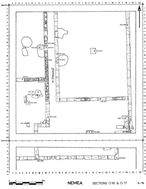
Sections 016 and 0 17
Section 0 16 continues the row of buildings along the south side of the sanctuary. The seventh in that series, as well as the west wall of the eighth building, had been discovered during 1975 in Section N 16. The eighth continues into 0 16 and occupies the western part of that section, while the ninth building lies wholly within 0 16. Early Christian farming activities were once again noted throughout both sec- tions, but here the disturbances were not so deep as elsewhere in the sanctuary. Nonetheless, they did churn up interesting earlier material such as an Archaic relief- pithos fragment (P 182; P1. 9:e) and many coins of Nemea neiglhbors such as those pictured in Plate 9 :f.34 From these levels in Section 0 17 came an iron ring with an eagle in intaglio on its carnelian bezel (GJ 18; Pl. 9:d) and again many
81 Blegen, op. cit. (footnote 25 above), p. 429 and fig. 7.
32 Pottery lot M 16:17.
33 Pottery lot M 16: 18.
EXCAVATIONS AT NEMEA, 1976 17
coins of which those in Plate 10:a are a representative selection.35 Coins from a different area of disturbances included a silver issue from Sikyon (P1. 10 b)."
With the clearing of the farming disturbances, the features of Section 0 16 were revealed (Fig. 5, Pls. 10:c, 11 :a). As has been the case elsewhere, the northern walls of the eighth and ninth buildings in the row fall beneath the northern baulk of the section, but the basic dimensicons of both are clear. The eighth buuilding (divided between N 16 and 0 16) has an east-west dimension of about 11.55 m. Since the north-south dimension can be estimated at about 11.50m., it would seem that the
eighth building was square in plan. Its soft yellow poros foundation blocks average about 0.55 m. in width and 1.10 im. in length with considerable portions of rubble socle preserved above. At the east end of the south wall two large re-used blocks fill an earlier doorway (cf. Fig. 5, P1. 1 1 :a). This eighth building varies from its western neighbors not only in its square shape, but also in the fact that its eastern wall continues to the south beyond the; southern or back wall of the structure. At a point some 6.30 m. south of that back wall, the east wall turns to the west at right angles for 2.35 m. and then turns back again to run southward out of Section 0 16. Two bases are west of and parallel to this extension of the east wall with the southern of the two set in line with the turn in the wall. These indicate that this part of the area behind the eighth building was roofed.
The ninth building is, like all the others in the row, built with soft yellow poros foundations. Its total east-west dimension is about 11.20 m. and its north-south dimension can be estimated at 14.50 m. A large, hard limestone base set on both short and long axes of the building will have provided a single, central roof support. The rubble socle above the poros foundations is, significantly, preserved only on the south wall of this building.
The east wall of this structure, like that of its western neighbor, continues south- ward beyond the line of the back wall. At a point some 4.60 m. south of the back wall, the east wall turns to the west at right angles and runs for a distance of 2.65 m. before stopping. Since this western return is located partially under the southern baulk of the section, its ultimate destination is not revealed within 0 16. A limestone base on line with and west of this return again indicates that this area was roofed. In the corner formed by the extension of the east wall and its western return (area 0/19-16/18, 19) heavy stone slabs have been set to form a bench. Along the west face of one of these slabs is a small and curious construction which was clearly intended to receive and to hold in place some further element (P1. 11 :c). Immediately west of this receptacle is a clay-lined rectangular pit which was found filled with carbon, ash, and bone. This whole corner begins, then, to resemble a cooking area. Although these accouterments are clearly later additions to the building, there is no evidence for the absolute date when they were installed.
35 Argos (C 708, C 719); Corinth (C 713, C 717); Hermione (C 710); Sikyon (C 720);
Phlious (C 745).
18 STEPHEN G. MILLER
I
r~~~~~~~~I
I---,~~~~~~~~~~~~-
t
L
L^rS
O~~ LISTAIRS~~~~~~~~~~~~~~~~~~~~~~~~~~~~~~~~~
El~~~~~~~~~~~~~~~~~~~~~~~~~~~~~~~~~~~~~~~~
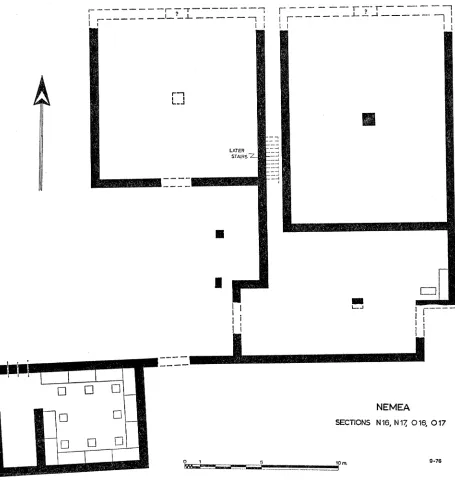
NEMEA
SECTIONS N 16, N 17, 0 16, 017
o 1 10
EXCAVATIONS AT NEMEA, 1976 19
Evidence from working layers and the foundation trenches of both the eighth and ninth buildings indicates that both were constructed at the same time strati- graphically and that this time was probably very early within the first quarter of the 5th century B.C.37
The fact that both buildings were not only constructed at the same time, but were actually parts of the same architectural unit, emerged only with the clearing of Section 0 17. Along the north side of this section is an east-west wall con- structed of the same soft yellow poros foundation blocks and joined to the southward extensions of the east walls of both the eighth and ninth buildings (Pl. 11:b). Furthermore, this east-west wall in Section 0 17 is almost certainly the continuation of the north wall of the " Dining Establishment " discovered in 1974 within Sec- tion N 17, although the orientation of the wall seems to change slightly beneath the baulk between N 17 and 0 17. Thus all of these elements belong together and once formed a building complex such as that reconstructed in Figure 6.
The form of the complex as shown in Figure 6 was short-lived. Within a few decades of its construction, the eighth building was taken over by a bronze-casting workshop. Indications of such an activity had been noted in 1975 within the south- east part of Section N 16, and much more emerged during 1976 within the southwest part of Section 0 16 (Fig. 5). In the disturbed upper layers of this area a con- centration of burnt material, bronze drippings, cinders, etc., began to be noted. In the same contexts were found several long, slender iron rods which will have served as armature for bronze casting (IL 39, IL 42, IL 49; Pl. 12:a). This material ex- tended over most of the southwest corner of the section, but its concentration in undisturbed levels was particularly high in area 0/2, 5-16/10, 15 and a variety of tools of iron, lead, bronze, and stone came out of the fill within this area. One example of these is a large stone grinder whose concave side is heavily worn and, at its point, virtually smooth (ST 341; P1. 12:c). The pottery from these levels, including a nearly complete skyphos (P 181; P1. 12 :e), places the date of this activity within the second half of the 5th century B.c.38
The clearing of this debris revealed a small furnace at 0/5-16/13, 14 which is constructed of burnt clay and which held a heavy concentration of ash, cinders, and bronze drippings (P1. 12:b, d). This furnace consists of a circular pit 0.95 m. in diameter and about 0.50m. deep. The southern half of the pit is roofed with clay which is pierced by four holes. This seems very likely to have been the place where bronze was melted for pouring into molds.
The casting itself took place in a series of pits which were cut through the floor within the southeast corner of the building. All of these contained tools, ash, carbon, and bronze drippings, but two were particularly productive. These were the circular pit at 0/2, 3-16/5, 7 and its southern rectangular neighbor at 0/3-16/7, 8. From these pits came, among many other tools, etc., a large mortar (P 192; P1. 12:f) and several fragments of a red-figured kylix (P 220 a-k; Pl. 12:g). The date of these
20 STEPHEN G. MILLER
pits is given by the blister ware found in them as probably the second half of the 5th century B.C.39 The most interesting material from these pits is, however, the many fragments of bronze statue molds which, once the casting had taken place, were left behind in the pits. It has been possible to reconstruct several large pieces of which two are presented here (TC 60; P1. 12:h. TC 59; Pl. 13 :a). These molds, with their various undulations and striations, would appear to be of draped, life-sized human limbs, although more study of them will be required. It also seems certain that more molds will be found in future excavations in the baulk to the west.
Several other casting pits were found in this area including two which cut through and utilized the foundations of the west wall of the ninth building. These pits are located at 0/8, 9-16/5 and at 0/8, 9-16/9 and, since they cut through the poros foundations, show that the building cannot have been standing when the area was used for bronze casting in the second half of the 5th century B.C. This early date for
the destruction of the building is also shown by the ceramic 40 and numismatic (P1.
13:b) 41 evidence found over the walls. The back room or "kitchen area " behind
this building continued in use, however, and the eighth building certainly was re- modeled and continued in use after the bronze casting activity had ceased. This remodeling included the closing of the door in the southeast corner of the building as previously mentioned, the construction of a light north-south wall from the south wall of the building to the first base in its " back room," and the construction of a light stairway along the east wall leading up to a room above the back room. Early Christian disturbances at the higher levels have obliterated the evidence as to when the building finally went out of use.
Sanctuary Summary
It seems appropriate at this point to review b-riefly the status of our knowledge concerning the history and topography of the south side of the Sanctuary of Zeus. Although no architecture of the Mycenaean period has been found in the sanctuary, the accumulation of ceramic evidence makes clear that the site saw a fair amount of activity during the Late Bronze Age. The Geometric and earliest Archaic periods have, as yet, been represented only by a relatively small amount of material, which has appeared exclusively in later contexts, and there is no evidence of sustained activity at Nemea until the first half of the 6th century B.c. Thus the received date of 573 B.C. for the foundation of the Panhellenic festival at Nemea42 is, at least in general terms, being substantiated.
The nature of the sanctuary during the 6th century is not yet known, but the outlines are clear by the mid-5th century B.C. By that time, and probably much earlier,
39 Pottery lots 0 16: 18-21. For the date of the inception of blister ware, see G. R. Edwards, Corinth, VII, iii, Corinthian Hellenistic Pottery, Princeton 1975, p. 144.
40 Pottery lots 0 16: 26-29.
41 C 506, C 516, C 517, all of Corinth although the silver issue is obviously too early to assist
in this question.
EXCAVATIONS AT NEMEA, 1976 21
there was an earlier Temple of Zeus more or less beneath and sharing the orientation of the extant temple.43 To the east of this temple lay the long and narrow altar, and to the south was a broad open plateia which was bordered on its southern side by a row of at least nine buildings. These buildings, all constructed within the first half of the 5th century, range in length from 12 to 22 meters and in width from 7 to 13 meters. Although their general situation is reminiscent of the treasury terrace at Olympia, their sizes alone appear to preclude the natural impulse to identify them as treasuries." It may be possible that the greater open area available at Nemea allowed larger buildings to be constructed as treasuries and the question soon becomes one of the proper architectural criteria for treasury identification. Perhaps a better analogy for the Nemea situation is to be found on Delos where a group of oikoi flank the northern and northeast sides of the Sanctuary of Apollo with the large "Oikos of the Naxians " southwest of the temple.45 It might, then, be best to identify the Nemea buildings as oikoi from various city-states. Although none of these can be identified with a particular city-state, mention should be made of two inscribed blocks discovered in later re-used contexts during the 1964 excavations.46 Each block is inscribed with a single word in the genitive plural cut in letter forms of the 5th century B.C. One block has POAIQN, the other ETTIAAYPION. It is obviously tempting to identify some one of the row buildings as the oikos of the Rhodians and another as the oikos of the Epidaurians.
These buildings will have formed the dividing line for the Sanctuary of Zeus, and their front walls may actually have denoted the formal boundary between the sacred and profane areas at Nemea. South of this line of buildings, with the excep- tion of the " Dining Establishment " in Section N 17, there is, as yet, no indication of any formal construction during the 5th century or earlier. Some evidence has, however, been noted which would suggest that the Nemea Stadium was located in or near the sanctuary during this period.48
In the late 5th or early 4th century the sanctuary saw a violent episode which seems to have been followed by a period of general deterioration. This situation was dramatically reversed in the second half of the 4th century by the construction of the
43 Hill, op. cit. (footnote 4 above), pp. 4, 29.
44 The largest treasury at Olympia, for example, is that of Metapontum (no. X) whose size
(9.47 X 13.95 m.) is smaller than at least four of the buildings at Nemea. The other treasuries at Olympia do not even approach the size of the Nemnea structures.
45 P. Bruneau and J. Ducat, Guide de Delos, Paris 1965, pp. 79 and 87. The word oikos is
used here in the sense defined by Bruneau and Ducat on their page 77, note 3: "eOiko: a Delos, les Oikoi sont des batiments sacres appartenant aux sanctuaires, mais qui ne servaient pas de lieux de culte. On y entreposait des offrandes et du matetriel divers; certaits pouvaient servir de lieux de reunions et de banquets rituels," Although the Delian oikoi are not laid out in a neat row like the Nemean buildings, and although the former have a prodomos not shared by the latter, their sizes are at least comparable.
46 I am indebted to Charles K. Williams for permission to mention these blocks.
47 The kitchen and dining facilities attached to the two easternmost buildings might almost
suggest a lesche rather than an oikos identification.
22 STEPHEN G. MILLER
extant temple, several large monuments to the south of the temple and of the altar, a very large monument far to the north of the temple,49 and the hard surfacing of the plateia in the southern sanctuary. A sacred grove will have been established at this time southeast of the temple, but the southern limit of the sanctuary appears to have remained constant along the line of the northern fa?ades of the " oikoi." It is not clear how many of the latter buildings remained in existence, although some " oikoi" were certainly no longer standing at this time. Further south, the kiln complex was a necessary part of the late 4th century building program which included the " xenon" and the " bath " as well as the temple.
These structures, and this general character of the sanctuary, seem to have en- dured throughout the remainder of the Hellenistic period, although the checkered his- tory of the Nemean Games and their shifting to and from Argos denote long periods of disuse and thus of deterioration. Following the 1st century B.C., when there may have been a destruction at Nemea,5" there is practically no evidence of activity in the southern part of the Sanctuary of Zeus until the 5th and 6th centuries after Christ.
THE STADIUM
It has become increasingly clear (see below) that the Stadium at Nemea was constructed in the second half of the 4th century B.C. and that it thus was a part of the building program mentioned above. Considering the subsequent history of the sanctuary, all the accouterments of the Stadium may be assigned provisionally to the late Classical or early Hellenistic period. Information regarding those accouter- ments was significantly increased during the 1976 excavation season.
About one fourth of the surface of the race track has now been revealed (Fig. 7, Pl. 13:c), including all of the southern closed end with its starting line. Not so rewarding was an attempt to pursue further to the east the line of terracotta water pipes discovered in 1975. The line of these pipes which provided fresh water for athlete and spectator was found to be broken at DD/7-32/7 and fragments of such pipes discovered scattered over the bedrock seats further up the slopes to the east and north indicate only a general direction for the original pipeline. One such fragment deserves mention although it was found fallen in the debris over the floor (TC 46; Pl. 14:a). This pipe matches those still in place in the composition of its clay and in its larger diameter, but it tapers quickly down to form a nozzle-like shape and begins to bend- at the smaller end before being broken away.
The evidence discovered in 1975, indicating that the Stadium was filled in some- time in the 5th century after Christ, was substantiated this year."' The newly dis- covered evidence includes a lamp (L 19; P1. 14:b) to be dated to the late 4th or
49 The reference is to the monument whose southwest corner lies in Section M 6; cf. Hesperia
44, 1975, pp. 155-157. The northern, western, and eastern limits of the sanctuary still remain to be defined.
5 Cf. Hesperita 45, 1976, p. 190.
EXCAVATIONS AT NEMEA, 1976 23
1 1 2 3 41 16 1 8t g 11011111113114115116117 118119120)
2 33
4 4
5 5
6 6
NEMEA |
STADIUM 10 10
11
1
12 12
13 ~~~~~~~~~~~~~~~~~~~13
14 14
15 15
511 '16
17 17
19 19
M1 21 2 0
2 2
3 3
4 4
5 5
6
9
10 T
j 3555 @ ~~~~3;55,056
12 1
13 ~~~~~~~~~~~~~~~~~13
15 1
17 1
18
BB cc 19 19
l111912011 1314151 171819110111112113114115116117118119120 20
5.196
3 -.3
4 ~~~~~~~~~~~~~~~~~~~~~~~~~~~4
- H1 4 ]
5~~~~~~~~~~~~~~~~~~~~~~~~~~~
6
3o ASS l
7 ~~~~~~~207
8 -
9 9
FL. 7. Sadis:3 1CC3355353 4 1
13 13
13~~~~~~~~~~~~~~~~~~~~~~~~~~~~~~~~~~1 1F41
15~~~~~~~~~~~~~~~~~~~~~~~~~~~~~~~~~~~~~1
17 +17
20
3 ~~~~~~~~~~~~~~~~~~~~~~~~~~~~~~~~~~3
4 ~~~~~~~~~~~~~~~~~~~~~~~~~~~~~~4
6 ~~~~~~~~~~~~~~~~~~~~~~~~~6
7 ~~~~~~~~~~~~~~~~~~~~~~~~~~~~~~~7
+ ~~~~~~~~832
24 STEPHEN G. MILLER
early 5th century after Christ.52 This fill contained earlier material of some interest such as a silver-plated bronze ring (GJ 17; P1. 14:d) whose raised bezel appears to be inscribed with the letters tA, and two lead tablets (IL 147, IL 91; P1. 14 :c, f, respectively). Both tablets have been inscribed more than once (the latter twice on the outside and once on the inside) and are difficult to read. The letters which can be made out are not inconsistent with personal names and may be indicative of curse tablets. Such an interpretation might lead to the conclusion that rivalry in the Nemea Stadium was not always friendly.
The clearing of this fill along the east side of the race track has revealed some sixty meters of the water channel. It continues north of the starting line in blocks of fairly hard limestone which average 1.78 m. in length, 0.30 m. in width and, based on one test trench, 0.43 m. in height. The upper surfaces of these blocks have been carved out to form the channel proper which averages 0.10 m. in width and 0.05 m. in depth. Many of these blocks preserve substantial traces of the reddish hydraulic cement with which they were once coated. The line of this channel is not straight, but appears to curve outward toward the east so that the race track will be widening toward its mid-point. In the course of the sixty meters of channel so far uncovered, a slope of about 0.76 m. down to the north is to be noted. Such a slope of about 1:79 is more than adequate for a good flow of water. At a distance of nearly thirty meters north of the settling basin just off the east end of the starting line, the water channel is again interrupted by another settling basin carved into a single block measuring 0.82 X 0.60 m., with the basin itself 0.29 m. deep.
A row of blocks set on the west or track side of the water channel stretches north and south of this basin (P1. 14 :e)." The lengths of these blocks vary from 0.62 m. to 2.01 m. and several of them are re-used in this position, but the widths are more or less constant at 0.45-0.50 m. Several of these blocks retain traces of a fine, white marble stucco which once covered at least their west faces. The total extent of these blocks to the north of the basin is 5.85 m. and to the south 6.58 m. Parallel to these blocks, and at an average distance of 1.35 m. east of the water channel, a line 0.45 m. wide of decomposed mud brick was found embedded in the slope (Fig. 7). This line is not preserved for the whole length of the stone blocks and its original extent cannot be determined. Between this line of mud brick and the water channel, and north of the settling basin, two different " islands " or piers of mud brick, averaging about 0.55 X 0.65 m. in size, were found built directly against the east face of the water channel. South of the basin, but also hard against the water channel, is another" larger area of mud brick some 2.40 m. long and varying in width from 0.40 m. to 0.60 m. The juxtaposition of this brick and the line of blocks seems hardly fortuitous, nor does the concentration of bronze and iron nails and pins found
52 For the general type see J. Perlzweig, The Athenian Agora, VII, Lamps of the Rom an
Period, Princeton 1961, nos. 1392, 1411, et al.
3 The south end of the southernmost of these blocks had been discovered already, in 1926, and