World Maritime University World Maritime University
The Maritime Commons: Digital Repository of the World Maritime
The Maritime Commons: Digital Repository of the World Maritime
University
University
World Maritime University Dissertations Dissertations
11-5-2017
A study on the e-navigation modus operandi
A study on the e-navigation modus operandi
Nurma Karima Sari
Follow this and additional works at: https://commons.wmu.se/all_dissertations
Part of the Navigation, Guidance, Control and Dynamics Commons
Recommended Citation Recommended Citation
Sari, Nurma Karima, "A study on the e-navigation modus operandi" (2017). World Maritime University Dissertations. 578.
https://commons.wmu.se/all_dissertations/578
WORLD MARITIME UNIVERSITY
Malmö, Sweden
A STUDY ON THE E-NAVIGATION
MODUS OPERANDI
By
NURMA KARIMA SARI
Indonesia
A dissertation submitted to the World Maritime University in partial
fulfillment of the requirements for the award of the degree of
MASTER OF SCIENCE
In
MARITIME AFFAIRS
(MARITIME SAFETY AND ENVIRONMENTAL ADMINISTRATION)
2017
ii
DECLARATION
I certify that all the material in this dissertation that is not my own work has been
identified, and that no material is included for which a degree has previously been
conferred on me.
The contents of this dissertation reflect my personal views and are not necessarily
endorsed by the University.
(Signature): _ _ _ _ _ _ _ _ _ _ _ _ _ _ _ _ _ _ _ _ _ _ _ _ _ _ _
(Date): _ _ _ _ _ _ _ _ _ _ _ _ _ _ _ _ _ _ _ _ _ _ _ _ _ _ _
Supervised by: Dr.-Ing. Michael Baldauf,
World Maritime University
Assessor:
Institution/organization:
Assessor:
iii
ACKNOWLEDGEMENTS
First of all, I wish to thank Allah, my creator, God almighty for all bless and chance
given upon me.
I am also gratefully thank to Ministry of Transport and Digital Infrastructure of
Germany and Ministry of Transportation of Indonesia for providing me a priceless
opportunity to pursue Master Degree at the World Maritime University (WMU). My
sincere appreciation also goes to my supervisor, Dr.-Ing. Michael Baldauf, for the
guidance and thorough discussion during the development of the dissertation.
I would also like to thank Mr. Robert Tremlett, who has shared valuable insights to
enhance my knowledge of e-Navigation.
I am forever thankful to my family in Palembang, my sister Kharisma Nadia, and my
best friend Harrison Porte, they have made available their support in a number of ways
during my study in Sweden. Humble appreciation presented also to all my friends at
WMU and nameless individuals for their support and contribution.
And finally, to Emmylia Salim, my beloved mother who has always been my greatest
strength. I am forever indebted to her for giving me the opportunities and experiences
that have made me who I am. Thank you for your faith, your constantly prays and
iv
ABSTRACT
Title of Dissertation : A Study on the e-Navigation Modus Operandi
Degree : MSc
Accidents in a marine setting have been overwhelmingly caused by human error (Weintrit, 2016). Around 50% of accidents occurring in the sea are attributed to navigational challenges. Maritime traffic is core in mitigating incidences such as collisions, grounding problems, oil spills, and piracy. Greater congestion and increased manning levels have provided impetus for developing reliable system to reduce laborious work. E-Navigation utilizes new and existing technologies that are acceptable within the operating standards. The central role of the process is to enhance marine safety as well as efficiency.
This dissertation takes an in-depth look at the modus operandi of the proposed e-Navigation concept, and discusses requirements and implementation plans of the complete concept as well as the potential limitations and benefits of e-Navigation. The findings of this study also revealed that the implementation of e-Navigation will create a mixed environment where the administrator and the mariner most likely have the same problem in the terms of cost and the necessity, which will identify the limitations of the concept. Some benefits were also recognized when the concept is applied properly. The study also found the importance of acknowledging non-SOLAS vessel within e-Navigation.
Through qualitative research, this dissertation involves the responses emanating from the experiences of the participants. As the concept is set to be completely implemented by 2020, interviews with key stakeholders give insight into attitudes on the role and predicted efficacy of the implementation of e-Navigation.
The concluding chapters discuss the results and offer recommendations on the effects of introducing the concept. The work concludes by summarizing all thoughts and ideas from all chapters.
v
TABLE OF CONTENTS
DECLARATION ... ii
ACKNOWLEDGEMENTS ... iii
ABSTRACT ... iv
TABLE OF CONTENTS ... v
LIST OF TABLES ... vii
LIST OF FIGURES ... viii
ABBREVIATIONS ... ix
1. INTRODUCTION ... 1
1.1 Background ... 1
1.2 Objective ... 3
1.3 Scope of the study ... 4
1.4 Methodology and sources of information ... 4
2. THE E-NAVIGATION CONCEPT ... 6
2.1 Introduction ... 6
2.2 The development of e-Navigation ... 8
2.3 Strategy Implementation Plan (SIP) ... 10
2.4 Risk Control Options (RCOs) ... 14
2.4.1 RCO 1 Integration of navigation information and equipment including improved Software Quality Assurance ... 14
2.4.2 RCO 2 Bridge alert management ... 15
2.4.3 RCO 3 Standardized mode(s) for navigation equipment ... 15
2.4.4 RCO 4: Automated and standardized ship-shore reporting ... 16
2.4.5 RCO 5: Improved reliability and resilience of onboard PNT systems ... 17
2.4.6 RCO 6 Improved shore-based services ... 18
2.4.7 RCO 7 Bridge and workstation layout standardization ... 19
2.5 Maritime Service Portfolio (MSP) ... 20
3. METHODOLOGY TO EVALUATE E-NAVIGATION MODUS OPERANDI ... 23
3.1 Introduction ... 23
3.2 Qualitative method ... 23
3.3 Interview and data source ... 24
3.4 Narrative analysis ... 26
3.5 Ethical considerations and limitation of the methodology ... 27
4. ANALYSIS OF E-NAVIGATION MODUS OPERANDI ... 29
4.1 Introduction ... 29
4.2 E-Navigation. How does it work? ... 31
4.2.1 Ashore ... 31
vi 4.2.3 The role of communication between ship to ship, ship to shore, shore to
ship, and shore to shore ... 35
5. POTENTIAL IMPACT OF THE IMPLEMENTATION OF E-NAVIGATION ... 37
5.1 Introduction ... 37
5.2 Identified shortcomings ... 39
5.2.1 The problem of data / information integrity. ... 39
5.2.2 No acknowledgement of information being received by the operator. ... 41
5.2.3 Loss of the traditional skills ... 42
5.2.4 Two tier society ... 43
5.2.5 Worst case scenario ... 44
5.2.6 Non-compliance possibility of non-SOLAS vessel within e-Navigation ... 45
5.3 Identified benefits ... 46
5.4 Discussion on the shortcomings and benefits of e-Navigation ... 50
5.5 Consideration for potential future direction on e-Navigation ... 52
5.6 S-Mode ... 52
5.7 Cybersecurity ... 54
6. CONCLUSION ... 60
REFERENCES ... 63
APPENDIX I ... 66
vii
LIST OF TABLES
Table 1. Solution and Sub-solutions (Source. Annex 7 NCSR 1/28) ... 13
Table 2. Type of Services and Services Provider of MSP (Annex 7 NCSR 1/28) ... 22
viii
LIST OF FIGURES
Figure 1. RCO Identification Process ... 10
Figure 2. E-Navigation architecture ... 30
Figure 3. The 7 pillars of e-Navigation ... 30
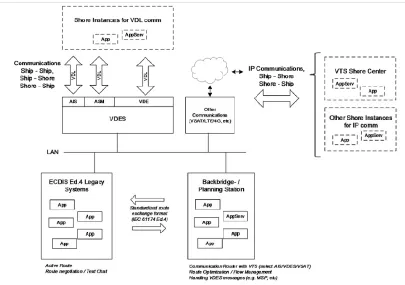
Figure 4. Concept Operation by VDES ... 36
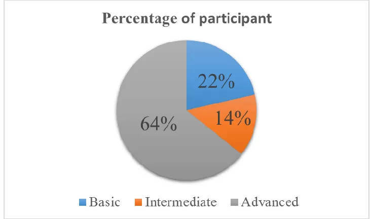
Figure 5. Statistic of participants’ e-Navigation technical knowledge…………...…….37
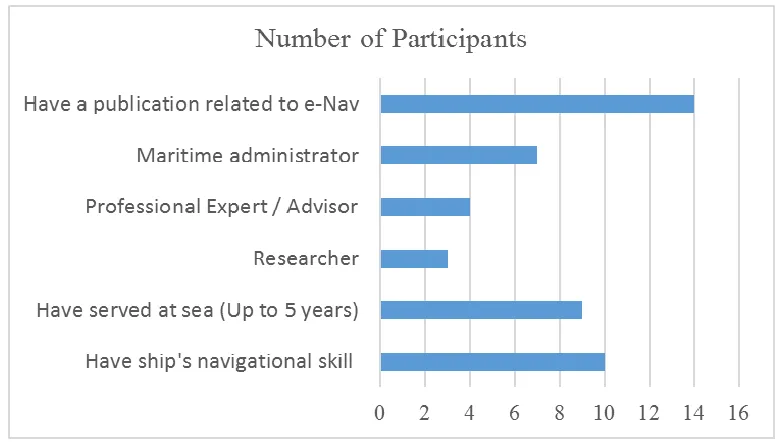
Figure 6. Distribution of category of interviewee professional background ……….….38
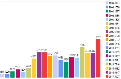
Figure 7. Total vulnerabilities by year ... 55
Figure 8. Total vulnerabilities by each type within 18 years ……….……….56
ix
ABBREVIATIONS
AIS Automatic Identification System
BES Bridge Equipment System
BIMCO Baltic and International Maritime Council
CG Correspondence Group
CLC Closed-Loop Communication
CIRM Committee International Radio Maritime
CVE Common Vulnerabilities and Exposures
ECDIS Electronic Chart Display and Information System
eNOA/D Electronic Notice of Arrival/Departure
EEC Electronic Communication Committee
ENC Electronic Navigational Chart
FSA Formal Safety Assessment
GDMSS Global Maritime Distress and Safety System
GNSS Global Navigation Satellite System
GRT Gross Tonnage
HMI Human Machine Interface
IALA International Association of Marine Aids to Navigation
and Lighthouse Authorities
IBS Integrated Bridge System
x IGO Intergovernmental Organization
IHO International Hydrographic Organization
IMO International Maritime Organization
INS Integrated Navigation System
ITU International Telecommunication Union
LPS Local Port Service
LORAN Long Range Navigation
MAS Maritime Assistance Service
MSC Maritime Safety Committee
MSI Maritime Safety Information
MSP Maritime Service Portfolio
NAS Navigational Assistance Service
NCSR IMO Sub-Committee on Navigation, Communications, Search &
Rescue
NGO Non Governmental Organization
OOW Officer of the Watch
PNT Resilient Position, Navigation and Timing.
RCO Risk Control Option
SAR Search and Rescue
SIP Strategy Implementation Plan
SOLAS The International Convention for the Safety of Life at Sea
xi TMAS Telemedical Assistance Service
TOS Traffic Organization Service
US United States
USCG United States Coast Guard
VDES VHF Data Exchange System
VMAS Vessel Monitoring and Alert System
VTS Vessel Traffic Services
WG Working Group
1
1. INTRODUCTION
1.1 Background
Without a doubt, accidents and incidents at the sea mostly caused by human error.
Weintrit (2016) pointed out “the combination of navigational errors and human failure
indicate a potential failure of the main ship systems used for navigation and control”.
Additionally, when the system is an extremely complex with low familiarity of the user,
the performance of human machine interaction can be problematic (Lee et al, 2015). The
research found that over 50 percent groundings and collisions are caused by the human
error, whilst navigation decision making was the main issue (The Nautical Institute,
2009). There are so many factors that make the decision making difficult such as lack of
awareness of a dangerous situation, insufficient resource awareness in a timely manner,
or fear of failure of unintended consequence. However, the procedures about making
decision is probably different in every situation, but combination of analytical thinking
and logical sense might be the best way to address these problems. Thus, the information
is the key where the decision maker needs to disprove bad propositions.
The revolution of technology has been growing fast, and continually changing. The
evolution has resulted much more technology interconnection. Thus, the technology has
been considered as a helpful tool to assist people to achieve their specific purpose, for
instance making ships more efficient or to prevent unintended situations, working
alongside traditional methods. Lützhöft (2004) discussed cognitive science and human
co-2 operation and compromise. She points out “when human and technology met and work
together, most of the time the human has to co-ordinate the resources, co-operate with
devices, and compromise between means and ends” (p.57).
However, the revolution of technology in maritime industry sometimes replaces
traditional methods. Today, we are facing the era of digitalization of information
management, and taking the advantages of it in order to keep up with the business’s
wave while protecting the people and the environment. In recognition to the digital age,
and the need to improve the integrity and accuracy of information used by the main
stakeholders, the IMO embarked on a new initiative, e-Navigation.
In Annex 20 of MSC 85/26 Add. 1 (para. 1.1) e-Navigation is defined as
“the harmonized collection, integration, exchange, presentation and analysis of marine
information on board and ashore by electronic means to enhance berth to berth
navigation and related services for safety and security at sea, protection of the marine
environment” (IMO, 2008). This initiative has a purpose to strengthen the navigation
system to create eligibility outcomes on the future of marine navigation. In addition, its
hoping to reduce the number of incident in marine environment caused by human error.
But does this make things easier or difficult to connecting ship and shore, and for them
to use the information? Thus, when humans are introduced to some new systems that are
controlled remotely, they often lose their sense of practical engagement. Further, the risk
of system failure has been raised as well as human factors issues. To maximize the
Human Machine Interface (HMI) the bridge system must be use good ergonomics and
preferably a low cost budget.
IMO through its Strategy Implementation Plan (SIP) as set out in the NCSR document
1/28 Annex 7, is addresses those risks by set up five prioritized e-Navigation solutions.
The NAV and COMSAR subcommittee and MSC created Correspondence Group (CG)
3 standard risk assessment tool to be used for the development of new rules and
regulations of IMO, as described in the Annex of MSC 83/INF.2, to finally established
the framework of SIP plan. In addition, it is hoped that e-Navigation concept will create
a system where the mariner and crew’s support can make a decision when they are facing unsafe situations on the ship’s bridge, as well as simplifying navigation tools
(Hong, 2015).
1.2 Objective
This dissertation researches e-Navigation’s modus operandi. It mainly focuses on studies
and discussions on how and to what extent the modus operandi of e-Navigation can be
utilised to improve safety in marine navigation. As e-Navigation is currently still being
developed, this dissertation will provide a benchmark for the benefits of e-Navigation to
harmonize all vessels, but also the steps that need to be considered for the
implementation of e-Navigation throughout the community.
In addition, this dissertation may serve as a reference in policy-making regarding
maritime safety of the member states of the IMO and the other actors of e-Navigation
related systems.Therefore, this dissertation:
Examines the potential of e-Navigation and addresses how to accommodate aspects such as multilingualism and diverse vessel types in features needed on
the ship, ashore, or on both sides.
Identify weaknesses and the benefits of the implementation of e-Navigation,
taking into consideration all vessels that are addressed by SOLAS as well as
those that share the same waters, and what operational modes required and
procedures that should be established.
4
1.3 Scope of the study
This dissertation includes six Chapters. Chapter 1 shows the background, objectives,
scope and methodologies of the research.
Chapter 2 includes an overview of the development of e-Navigation, through examining
and reviewing SIP developed by the IMO, including a general overview of tool kits used
in IMO e-Navigation, namely Risk Control Option (RCO) and Maritime Service
Portfolio (MSP).
Chapter 3 determines the methodology to be used in this dissertation. To define the
methodologies, this chapter introduce the interview and cross check between results of
interview and the SIP developed by the IMO and other e-Navigation related documents.
The researcher also discusses about the limitation of the methodology.
Chapter 4 gives an in-depth analysis of e-Navigation modus operandi, including insights
gained from interview results and SIP by IMO. The analysis will concern a shore side
and an onboard side, as well as the role of communication between ship to ship, ship to
shore, shore to ship, and shore to shore.
Chapter 5 discusses the potential impact of the implementation of the e-Navigation
concept. Here, the shortcomings and the benefits, as well as the discussion of the impact
of e-Navigation will be discussed. Recommendations for the future of e-Navigation will
also be introduced and outlined.
Finally, Chapter 6 gives a summary and includes a final conclusion of this dissertation.
1.4 Methodology and sources of information
The research questions, which reflect the research objectives of this paper, are as
5 1) Will there be a significant change of how the operator ashore and on board
conduct navigation of vessels or advisory services to them with respect to
e-Navigation and non e-Navigation vessels.
2) Will there are differences of “quality” and accuracy of e-Navigation services
offered by different Coastal States to all vessels and how will a vessel deal
with this.
3) What are the steps (if any) need to be taken to avoid grounding or collision
with an assumption is taken that vessels and shore stakeholders that are
interacting with each other will have different levels of sophistication of
navigation and control equipment? Additionally, different levels of
e-Navigation services will be experienced by the mariner for Vessel Traffic
System (VTS), weather forecast, Just in Time Arrival at narrows or port
requiring different steps.
To answer these questions, this dissertation will use qualitative research. An
examination and review of the e-Navigation related documents developed by the IMO
and other related research papers will be carried out in order to define the appropriate
analysis tools. The aforementioned documents were collected from the IMO website,
other sources on the internet, and the WMU library. In addition, an online interview with
stakeholders will be carried out as one of the qualitative analysis items in order to verify
6
2. THE E-NAVIGATION CONCEPT
2.1 Introduction
As already stated, e-Navigation is a major initiative of the International Maritime
Organization (IMO), and is intended to be implemented according to Strategy
Implementation Plan (SIP), which was approved by MSC 94 in November 2014. The
plan contains a list of tasks required to be conducted in order to address five prioritized
e-Navigation solutions, namely:
S1: Improved, harmonized and user-friendly bridge design;
S2: Means for standardized and automated reporting;
S3: Improved reliability, resilience and integrity of bridge equipment
and navigation information;
S4: Integration and presentation of available information in graphical
displays received via communication equipment; and
S5: Improved Communication of VTS Service Portfolio (not limited
to VTS stations).
It is expected that these tasks, when completed within the period of 2015–2019, should
provide the maritime industry with harmonized information that is essential to start
designing products and services to meet the e-Navigation solutions (IMO, 2014).
The IALA and IMO who have already put forth great efforts to act as a driver of the
7 understood that, in order to facilitate e-Navigation, processes used for technical transfer
of data and information should be machine to machine and not require any human
intervention to either receive or portray the information (IMO, 2014).
According to Baldauf and Hong (2016), the situation of maritime safety is different from
country to country especially in coastal areas and SOLAS ships are always interfaced
with non-SOLAS ships in real maritime practices. Furthermore, it has been realized
within the community that e-Navigation should be able to include all vessels and not just
a few complex ones; as such, a range of inter-communicability is required to transfer
data, ensuring that all vessels are included within the concept. Though satellite
communications are recognized to be an important element for e-Navigation, it is also
recognized that other more basic communication would be required alongside it.
This inter-communicability needs to have led to work for evolving language independent
protocols for the transfer of information between vessels, and vessels and infrastructure
to include a methodology for the portrayal of data within the language of an operator.
This work builds on “the international code of signals”, first introduced at the
International Radiotelegraph Conference in Madrid in 1932, and still used today.
Furthermore, e-Navigation not only impacts the way information will be communicated
to a vessel, but also how information will be used on board. Because it requires data to
be provided machine to machine, and because the purpose of e-Navigation is to
improved resilience of the communication link but also to be used VTS and ship
reporting. The interaction between ship and shore is likely to rely more and more on
automated, or semi-automated procedures, where the mariner becomes an observer, and
in certain circumstances, may even in the future be provided with some resolved
solutions which can be rejected or accepted. This brings in to question what should
happen to solutions that have not been acted upon by the mariner. What is the default
8 It is observed during this research that e-Navigation bridge of the future as will the
operation centers ashore, result in changed roles of the watch keeper. The equipment
itself will be designed to provide direct data access to and from systems used for the
navigation and control, and possibly even effect the control of a vessel. Automatic
information updates, instead of the current system of manual inputs in the form of
corrections, will also be implemented.
2.2 The development of e-Navigation
During the MSC 81 session in 2006, USA, Japan, the Marshall Islands, the United
Kingdom, the Netherlands, Norway, and Singapore made a joint proposal for
e-Navigation, a concept that would contribute to reducing navigational accidents, error,
and failures. As such, the NAV and COMSAR Sub-Committees developed a strategy for
the development and implementation of e-Navigation (NAV 54/25 Annex 12) and a time
frame for implementation (NAV 54/25 Annex 13), with suitable suggestions by several
organizations such as the IALA and IHO. Ultimately, the MSC approved the strategy
called the e-Navigation SIP (NCSR 1/28 Annex 7), and expect it to be implemented in
2020.
There are many stakeholders involved with the evolution of e-Navigation, who are
working closely with the IMO NCSR sub-committee. A good understanding of the
contribution of these other organizations is needed, as e-Navigation is dependent on the
IALA, IHO, as well as the IEC and ITU. These organizations are very important in their
own way for the development of the key components required for the communication
and portrayal of information, as well as the design of the equipment used. For instance,
the IALA is ready to change its status from Non Governmental Organization (NGO) to
Intergovernmental Organization (IGO) in order to assist the advancement and
accordance of aids to navigation globally (Weintrit, 2016). The interface between ashore
9 organizations. Additionally, there are procedures within the e-Navigation that will have
most effect on the bridge in the future:
portrayal of information required for safe navigation.
communication of information from ship to ship, ship to shore, and shore to ship.
Both of these are interdependent of each other and will heavily involve the Electronic
Chart Display and Information Systems (ECDIS) referred to IALA, IHO and IEC. And
also satellite communication and VHF Data Exchange System (VDES) referred to IALA
and ITU.
The e-Navigation concept “covers ship-side technologies like Integrated Navigation
Systems (INS) integrating electronic charts, navigation and conning data or integrated
surveillance systems on shore with technologies like VDES, Automatic Identification
Systems (AIS), Global Maritime Distress and Safety System (GMDSS), Resilient
Positioning, Navigation and Timing (PNT)” (Hahn et al., 2016). Furthermore, by
forming a competent national SIP, member states are expected to enjoy the prosperity of
applying e-Navigation to their waters in the terms of their distinctive priorities (Baldauf
and Hong, 2016). Therefore, e-Navigation will establish more efficient and safer transit
of vessels. This initiative provided that the communication link is used correctly,
cooperation for maritime safety and security, protection of marine environment, and the
appropriate interaction between stakeholders ashore and onboard is dealt with correctly.
Many research and vast resources have tackled e-Navigation as well as its related
conventions, such as SOLAS, which regulates the safety of navigation. E-Navigation
also affects not only all vessels, but also the country’s conformation with those
conventions related to their own fleets, their VTS, their ports, and how they interact with
vessels as a coastal state. SOLAS presents itself as a major beacon for the evolution of
10 within e-Navigation, while a SIP (IMO NCSR 1/28) sets out the work required for
stakeholders to enable e-Navigation. This provides guidance covering all aspects of
human interaction in the way of user friendly bridge designs, technical requirements for
automated reporting; and as such, the inter-communicability between stakeholders and
required regulating bodies.
2.3 Strategy Implementation Plan (SIP)
In 2014, MSC 94 established a SIP through NCSR 1/28 Annex 20. As the core of the
implementation of e-Navigation, the SIP provides solutions for the gaps analysis and
user needs through the Formal Safety Assessment (FSA), which are addressed in the
seven parts of the RCO and sixteen services of the MSP in the SIP as a kits to achieve
the five prioritized e-Navigation solutions and sub solutions.
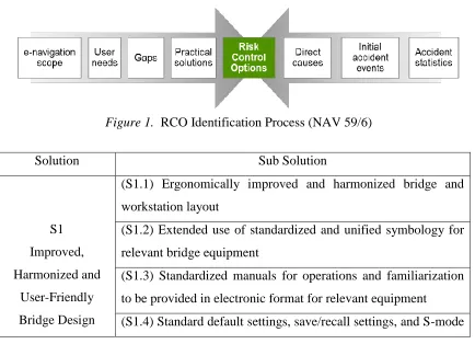
Figure 1. RCO Identification Process (NAV 59/6)
Solution Sub Solution
S1
Improved,
Harmonized and
User-Friendly
Bridge Design
(S1.1) Ergonomically improved and harmonized bridge and
workstation layout
(S1.2) Extended use of standardized and unified symbology for
relevant bridge equipment
(S1.3) Standardized manuals for operations and familiarization
to be provided in electronic format for relevant equipment
11 functionalities on relevant equipment
(S1.5) All bridge equipment to follow IMO Bridge Alert
Management
(S1.6) Information accuracy/reliability indication functionality
for relevant equipment
(S1 6.1) Graphical or numerical presentation of levels of
reliability together with the provided information
(S1.7) Integrated bridge display system (INS) for improved
access to shipboard information.
(S1.8) GMDSS equipment integration – one common interface.
S2
Means for
Standardized and
Automated
Reporting
(S2.1) Single-entry of reportable information in single-window
solution.
(S2.2) Automated collection of internal ship data for reporting.
(S2.3) Automated or semi-automated digital
distribution/communication of required reportable information,
including both "static" documentation and "dynamic"
information.
(S2.4) All national reporting requirements to apply standardized
digital reporting formats based on recognized internationally
harmonized standards, such as IMO FAL Forms or
SN.1/Circ.289.
S3
Improved
Reliability,
Resilience and
Integrity of Bridge
Equipment and
(S3.1) Standardized self-check/built-in integrity test (BIIT) with
interface for relevant equipment (e.g. bridge equipment).
(S3.2) Standard endurance, quality and integrity verification
testing for relevant bridge equipment, including software.
(S3.3) Perform information integrity tests based on integration of
12 Navigation
Information
monitoring concept
(S3.4) Improved reliability and resilience of onboard PNT
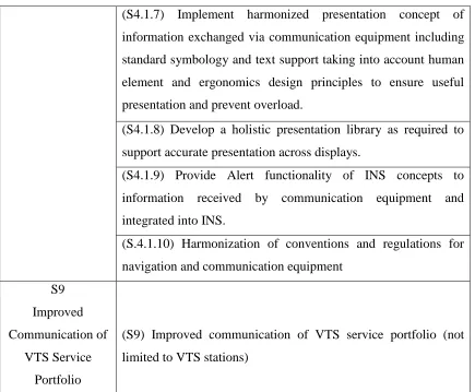
information S 4 Integration and Presentation of Available Information in Graphical Displays Received via Communication Equipment
(S4.1) Integration and presentation of available information in
graphical displays (including MSI, AIS, charts, radar, etc)
received via communication equipment
(S4.1.1) Implement a Common Maritime Data Structure and
include parameters for priority, source, and ownership of
information.
(S4.1.2) Standardized interfaces for data exchange should be
developed to support transfer of information from
communication equipment to navigational systems (INS).
(S4.1.3) Provide mapping of specific services (information
available) to specific regions (e.g. maritime service portfolios)
with status and access requirements.
(S4.1.4) Provision of system for automatic source and channel
management on board for the selection of most appropriate
communication means (equipment) according to criteria as, band
width, content, integrity, costs.
(S4.1.5) Routing and filtering of information on board (weather,
intended route, etc.).
(S4.1.6) Provide quality assurance process to ensure that all data
is reliable and is based on a consistent common reference system
13 (S4.1.7) Implement harmonized presentation concept of
information exchanged via communication equipment including
standard symbology and text support taking into account human
element and ergonomics design principles to ensure useful
presentation and prevent overload.
(S4.1.8) Develop a holistic presentation library as required to
support accurate presentation across displays.
(S4.1.9) Provide Alert functionality of INS concepts to
information received by communication equipment and
integrated into INS.
(S.4.1.10) Harmonization of conventions and regulations for
navigation and communication equipment
S9
Improved
Communication of
VTS Service
Portfolio
(S9) Improved communication of VTS service portfolio (not
limited to VTS stations)
Table 1. Solution and Sub-Solutions Prioritized e-Navigation (Source. Annex 7 NCSR
1/28)
Therefore, it is crucial to have a deep understanding of the SIP to see how e-Navigation
concept works. Further, the RCOs will be discussed analyzed in the next section by the
researcher are extracted by the IMO related documents such as NAV. 59/6 and NCSR
14
2.4 Risk Control Options (RCOs)
2.4.1 RCO 1 Integration of navigation information and equipment including improved
Software Quality Assurance
As it is stated in Annex 1 NAV. 59/6 presented by Norway, RCO 1 is related to
sub-solutions: S1.6, S1.7, S3.1, S3.2, S3.3, S4.1.2, and S4.1.6. The integration of navigation
information and equipment will help the navigator when it comes to navigational
decision making. In addition, there are 7 elements contained in RCO 1 that are
incorporated with INS standards, as listed below:
1. Task route planning and monitoring
2. Task collision avoidance
3. Task navigation control data
4. Task status and data display
5. Display
6. Redundancy of important equipment
7. Software testing
As stated in the main RCO 1 text, it is essential that navigational information be
centralized, allow it to be visible from all work stations. This will enable quicker
decision-making and give crew members an overview of relevant information.
Additionally, the document states that:
Sophisticated bridge navigational systems are increasingly integrated with each
other and with other kinds of systems on the ship. This, as well as the implicit
ability of these systems to influence each other, increases complexity. As such, it
is of increasing importance that these systems are usable, available, reliable and
15 2.4.2 RCO 2 Bridge alert management
RCO 2 is related to S1.5. The purpose of having a unified bridge alert system is to
enable harmonized priority, classification, handling, distribution, and presentation of
alerts (NAV 59/6). Through this system, situational awareness in the bridge team will be
increased, so that when it comes to unwanted events, the bridge team will be able to
respond quickly and save time on decision making. Furthermore, the vessel which have
an audible alarm on the bridge will prioritize dangerous scenarios, such as collision or
grounding displayed on the central alert management HMI.
According to the document NAV 59/6, one of the key problems faced in vessels without
a centralized alert system is that alerts are not always easily identified. Additionally, if
all alerts are not coming from a central system, it is often difficult to prioritise the alerts.
Additionally, “Potentially unnecessary distractions of the bridge team by redundant and
superfluous audible and visual alarm announcements may occur, increasing the
cognitive load on the operator.” (NAV 59/6 p. 23). With a centralized system,
information from different alert sources will be available in the same place, facilitating
decision-making with regard to prioritization.
2.4.3 RCO 3 Standardized mode(s) for navigation equipment
RCO 3 is related to S1.4. It refers to the standardisation of technology, an essential facet
of a safe operation at sea. As stated in Annex 7 NCSR 1/28:
Standard modes or default display configurations are envisaged for relevant
navigational equipment. Such standard modes should be selectable at the task
station and would reset presentation and settings of information to provide a
16 This is particularly important in the context of commercialism: it is important to keep in
mind that companies developing e-Navigation technologies must compete in the free
market and maintain a competitive advantage. Therefore, guidelines and standards on
display layouts and essential functions should be mandated for all e-Navigation
products.
Enforcing such guidelines would ensure that a standardized training program can be
implemented so that all crew members are on the same page in terms of using the
e-Navigation technology. As stated in Annex 7:
Safe navigation relies on the ability of key personnel of the bridge team to easily
operate navigational equipment as well as to comprehend the information that is
presented to them. Without proper familiarization, which can sometimes take a
significant period of time due to the current differences between operating
systems, this is not always the case when someone is new to a particular setup.
Lack of familiarity with bridge equipment which can result in slow responses
due to not finding correct information, system, control function or alarm is
therefore likely to adversely affect safe navigation. (p. 23).
Annex 7 further describes specifics on the types of standardization that should be in
place, mentioning information display, such as symbols and colours (in relation with
MSC.191(79)); a standard layout for information presentation; as well as a standard
mode of operation that can be accessible with a single user action.
2.4.4 RCO 4: Automated and standardized ship-shore reporting
RCO 4 is related to S2.1, S2.2, S2.3, S2.4. It stipulates the automation of ship-shore
reporting through making information more easily accessible, in a user-friendly format.
17 is predicted to reduce workload, as forms are usually filled out manually by crew
members, and such paperwork often takes 2 hours to complete.
The proposed automation system would integrate and collect the data and information
needed for reporting. Additionally, since 2005 US established Electronic Notice of
Arrival/Departure (eNOA/D) that requires all vessels up to 300 GRT have to use for
in/out clearance in the US waterways. In Europe, the Facilitation Committee and the
European Commission have already begun developing a system for ship-shore reporting.
Europe SafeSeaNet (SSN) has established an Internet-based system to exchange the
information between different authorities, which has implemented by Norway and
Iceland (EMSA, 2012).
2.4.5 RCO 5: Improved reliability and resilience of onboard PNT systems
RCO 5 is related to sub-solution 3.4. It outlines standards for enabling reliable Position
Navigation and Timing (PNT) data, which is derived from a ship’s position through the
Global Navigational Satellite Systems (GNSS), and looking at multiple position and
timing points to velocity, course, or speed over the ground. It goes without saying that
this information is crucial in navigation at sea.
RCO 5 emphasizes the importance of resilience and reliability of PNT data. Resilience is
defined as the system’s ability to compensate for disturbances in data collection, such as
malfunctions or breakdowns in the system. Increasing resilience of a PNT system does
not necessarily require setting up extra GNSS systems; but is instead achieved “through
a combination of existing space-based and terrestrial systems, modernized and future
radio navigation systems, ship-based sensors and other services.” (NAV. 59/6 p. 24).
Some of these systems include:
1. Inertial navigation systems;
18 3. Electronically-enabled human-observed bearings and distances (i.e. Modern
electronic coastal navigation using an e-pelorus, radar and ECDIS);
4. Autonomous celestial navigation; and
5. Other possibilities that could arise from research, for example in the areas of
defence and robotic vehicle navigation. (p. 24)
According to NAV. 59/6, reliability on the other hand, refers to the chance and
consistency at which the PNT system performs a function successfully under given
conditions, for a specified time. As discussed in the section on RCO 3, standardized user
interfaces and sets of functions would increase reliability, and ensure that all crew
members, internationally, could be trained using the same system.
2.4.6 RCO 6 Improved shore-based services
RCO 6 is related to S4.1.3 and solution S9 as it is stated in NAV. 59/6. The Maritime
Service Portfolio refers to a collection of information gathered by VTSs, ports, and other
stakeholders at shore. This information includes: “navigational warnings, incidents,
operations, tide, AIS, traffic regulations, chart updates, meteorological conditions, ice
conditions, etc.” (NCSR 1/28 p. 25).
In line with RCO 1, this information should be centralized, standardized, automated, and
easily accessible at all work stations. This information may be helpful in navigation,
and contrary to the paper-based delivery system used today, documents such as
Maritime Safety Information (MSI), should be made digitally available. Digitizing this
information would also allow for only voyage-relevant information to be shared with the
respective crew. In the current system, “the Officer of Watch (OOW) may potentially
receive several MSI messages daily, of which a large portion of the messages may not
be of concern to the voyage” (NCSR 1/28 p. 25). With all of this noise, it is easier to
19 “the most appropriate platform to present MSI may be either the INS tasks route
monitoring and status and data display (resolution MSC.252(83)) or the ECDIS unit and
optionally on another navigational display.” (p. 25). In addition, as stated in Annex 7
NCSR 1/28:
Secondly, notices to mariners, updates to Electronic Navigation Chart (ENC) and
corrections to all nautical publications should be received electronically without
any delays in the delivery. Distribution via post is time consuming and may
introduce risks to the ships sailing in waters, for which the nautical charts are not
up to date. (p. 25).
Such information should be “fully integrated into the INS tasks route monitoring and
status and data display (resolution MSC.252(83)) or the ECDIS unit and optionally on
another navigational display” (p. 25). Updates and corrections should not have any file
type dependencies, and should not require manual transfer by an operator.
This will not only increase efficiency, but also reduce costs of operation. However,
important to note is that changes to operating procedures must be structured, involve
sufficient training regimes to manage the data information, and conducted in a logical,
standardized manner. Such changes should remain compatible with current systems, and
build on their foundation.
2.4.7 RCO 7 Bridge and workstation layout standardization
RCO 7 outlines standards for bridge and workstation layouts. It is only logical that
equipment layouts that do not consider workflow or utility adversely influence the
performance of marine navigation operations. While developments in ergonomic
workstation and bridge design exist, there are currently not standards for universal
20 Reference could be made to SOLAS regulation V/15 on Principles relating to
bridge design, design and arrangement of navigational systems and equipment
and bridge procedures, MSC/Circ.982 on Guidelines on Ergonomic Criteria for
Bridge Equipment and Layout, SN.1/Circ.265 on Guidelines on the Application
of SOLAS regulation V/15 to INS, IBS and bridge design, SN.1/Circ.288 on
Guidelines for bridge equipment and systems, their arrangement and integration
(BES) and ISO8468 on Ships Bridge layout and associated equipment. (p. 26).
In a similar way to standardization of information and system displays discussed in RCO
3, standardization of bridge designs would allow all crew members to undergo the same
training regime and increase collective familiarity with bride and workstation layout and
function.
2.5 Maritime Service Portfolio (MSP)
As stated in NAV 59/6, MSP is defined and described as “the set of operational and
technical services and their level of service provided by stakeholders in a given sea area,
waterway, or port, as appropriate. An MSP may also be interpreted as a set of "products"
provided by a stakeholder.” (p. 7). More specifically, as part of the improved provision
of services to vessels through e-Navigation, MSPs have been identified as the means of
providing electronic information in a harmonized way, which is part of solution 9. The
proposed list of MSPs is presented in table below. Further information about MSPs is set
out in annex 2 of NCSR 1/28, and annex 3 of NAV 59/6.
According to IMO NCSR 1/28, Annex 7 addresses the following six areas that have
been identified for the delivery of MSPs:
1. Port areas and approaches;
2. Coastal waters and confined or restricted areas;
21 4. Areas with offshore and/or infrastructure developments;
5. Polar areas; and
6. Other remote areas. (p. 10)
The following table gives an overview of the services and responsible service providers
outlined in the document:
No Identified Services Identified Responsible Service Provider
MSP 1 VTS Information Service
(IS)
VTS Authority
MSP 2 Navigational Assistance
Service (NAS)
National Competent VTS Authority/
Coastal or Port Authority
MSP 3 Traffic Organization Service
(TOS)
National Competent VTS Authority/
Coastal or Port Authority
MSP 4 Local Port Service (LPS) Local Port/Harbour Operator
MSP 5 Maritime Safety Information
Service (MSI)
National Competent Authority
MSP 6 Pilotage service Pilot Authority/Pilot Organization
MSP 7 Tugs Service Tug Authority
MSP 8 Vessel Shore Reporting National Competent Authority,
Ship-owner/Operator/Master
MSP 9 Telemedical Assistance
Service (TMAS)
National Health Organization/dedicated
Health Organization
MSP 10 Maritime Assistance
Service (MAS)
Coastal/Port Authority/Organization
MSP 11 Nautical Chart Service National Hydrographic Authority/
Organization
22
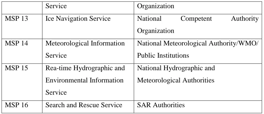
Service Organization
MSP 13 Ice Navigation Service National Competent Authority
Organization
MSP 14 Meteorological Information
Service
National Meteorological Authority/WMO/
Public Institutions
MSP 15 Rea-time Hydrographic and
Environmental Information
Service
National Hydrographic and
Meteorological Authorities
MSP 16 Search and Rescue Service SAR Authorities
23
3. METHODOLOGY TO EVALUATE E-NAVIGATION MODUS OPERANDI
3.1 Introduction
This chapter introduces the research methodology and how it has guided data collection,
analysis, and development of the theory. Subsequently, data collection procedures are
illustrated and discussed in-depth to get an overview of the entire process. This is
followed by limitations which were encountered during the interview. Finally, it presents
a brief discussion on qualitative techniques used to analyze the data collected.
3.2 Qualitative method
Comprehensive literature review comprising of peer reviewed journals covering
e-Navigation were consulted. Besides, participation of the key stakeholders such as the
IMO, IALA, and maritime administrations formed part of the study. They included
publications on the internet, conventions, and regulations that are related to e-Navigation
or impacted by it. The major benefit of qualitative type of study is attributed by
versatility of information, and the diverse data that can be collected through interview
instruments.
Lützhöft (2004) asserts that questionnaires are expensive to administer and yield little
that can be used pragmatically. She also pointed out that “quantitative data may be
useful in measuring attitude across a large sample, but paper interviews perform a
24 knowledge, and experiences” (Lützhöft, 2004, p. 17-20). Marshall and Rossman (1999)
discussed the characteristics of qualitative methods, such as valuing participant’s
perspectives, focusing on everyday life experiences, enquiry and primary descriptions.
Through qualitative research, this dissertation involves the responses emanating from the
experiences of the participants. The researcher transcribed interviews and analyzed
them on a comparative and narrative basis to bring out the complexity of the work
situation.
3.3 Interview and data source
The most important reason for using this method is traceability of facts regarding
e-Navigation. One aspect of consideration is interviewing people with facts and versatile
knowledge in the area of concern. In order to get an in-depth understanding of the topic,
it is crucial to interview experts in this area. For example, the investigations in the frame
of ACCSEAS project have shown that sometimes even lectures and instructors were not
aware of what e-Navigation means (Baldauf, 2015).
For that reason, the interview candidates were selectively chosen with the goal of
obtaining detailed and informative responses. Patton (2002) has described the concept of
purposeful sampling comprehensively. He stated that:
The logic and power of purposeful sampling lie in selecting information-rich
cases for study in depth. Information-rich cases are those from which one can
learn a great deal about issues of central importance to the purpose of the inquiry,
thus the term purposeful sampling. Studying information-rich cases yields
insights and in-depth understanding rather than empirical generalizations (p. 230,
emphasis in original).
For this dissertation, the researcher did the interviews of key personnel who have been
25 organizations such as IALA, IMO, The Nautical Institute, CIRM, and officials of the
maritime administrations were invited to participate. The participants selected come
from countries such as Australia, Canada, Denmark, Germany, Norway, Republic of
Korea, United Kingdom, United States, Singapore, and Sweden. The researcher found
the interview candidates through WMU and IMO networking, as well as the candidate’s
publication on e-Navigation development, articles in academic journals, professional
magazines on internet, and e-Navigation seminars. During the research, a total of 23
experts/stakeholders were chosen for interviews; 14 out of 23 participants confirmed
their participation by sending back their answers via email.
The online interviews were conducted via email during May – August 2017. To achieve
this, interview questions were emailed to individual participant for responses.
Opdenakker (2006) affirms that email communication has enumerable advantages
compared to other mode of collecting data. One, confidentiality of information is highly
respected hence improving the reliability. Additionally, it facilitates wider coverage of
respondents irrespective of geographic separation. Further, through this method, the
researcher can accurately develop and standardize the questions, and less disturbance is
witnessed hence efficiency to present the best responses possible from the participant.
Moreover, the researcher divided the interview questions into five sections bearing two
parts: background review and technical and/or working conditions. For background
review, the interviewee described their professional background in the maritime industry
and its relation mainly to e-Navigation. The question also instructed them to list their
publications (e.g. journal articles, seminar presentations or reports) on e-Navigation, and
indicate the level of their own e-Navigation technical abilities. This part of the interview
helped the researcher to find out on-sea experience or skill in ship navigation. On the
technical and/or working condition’s part, the interview questions were divided into four
26
e-Navigation in general. This helped the researcher understand the works of the
e-Navigation from several different perspectives.
Apart from the e-mail interview questions, the researcher also had informal interviews
with maritime users, experts and scholars in some particular fields relevant to the topic
for example cyber security. Personal notes were recorded for comparison with the
interview result and SIP to get more understanding on e-Navigation works. Results will
be shown in chapter 4.
Consequently, analysis of data collected from the interviews and SIP was conducted to
arrive at solutions to the problem statement. Along, it generated conclusions and
recommendations. Notably the analysis was conducted based on interviewee’s personal
experiences with e-Navigation, the SIP established by the IMO, and personal notes. The
limitations and benefits of e-Navigation for the maritime field and stakeholders will be
shown in chapter 5.
3.4 Narrative analysis
Interview questions offered as little guidance as possible to allow the interviewees to
talk about what was of importance to them within the given context. The researcher then
extracted those phenomena or significant experiences of the interviewee as a
construction to developing a theory using narrative analysis. Boréus and Bergström
(2017) discussed narrative analysis as a viable way to organize and gain insights of
participants in social science research, which is why narrative analysis is the primary
tool used for the interview responses in this dissertation.
Additionally, Riessman (2008) supported this method with emphases on interviewing
and the process of transcribing interviews as data for narrative inquiry. Labov (1969)
described five key components of such narratives (as cited in Boréus & Bergström,
27 1. An abstract (summary of the event);
2. Orientation (time, place, situation, participants);
3. Complicating action (sequence of events);
4. Resolution (tells what finally happened);
5. Coda (returns the perspective to the present).
According to Kisser (1996), the value of the narrative analysis is “privileged human
agency and it deals with particular and the specific, rather than the collective and
statistical” (as cited in Boréus and Bergström, 2017, p. 124). Moreover, Robertson
(2000) and Feldman and Almquist (2012) pointed out some of benefits of using narrative
approach, stating that a “narrative attunes the analyst to nuance, helping us see things
that would be overlooked in more technical readings, and making us aware of absences
as well as presences” (as cited in Boréus and Bergström, 2017, p. 124). For the current
study, the researcher also used the categorical-content approach as a mode of reading
narratives. Lieblich et al. (1998) defined this mode focus on “the content of narratives as
manifested in separated parts of the story, regardless of the context of the complete
story” (as cited in Boréus and Bergström, 2017, p. 131).
3.5 Ethical considerations and limitation of the methodology
Although the interview method has many benefits, there are some limitations as well.
For example, on occasion participants may have difficulty understanding the context of
the question. In these instances, the researcher must respectfully bring them back to the
content. But, in an online interview conducted by email, there are added challenges for
the interviewer and the participant to connect directly in order to pursue follow up
clarifications, especially when the participants are not in the same country/time-zone.
There were also some unforeseen obstacles for this methodology, particularly in terms of
28 in great detail, but others gave quick answers or comments that did not really address
some part of question properly. Lastly, some participants were not willing to answer.
Marshall (2016) mentioned that face to face interviews are more impactful since
clarification are done there and then. In hindsight, perhaps, face to face interview would
have afforded the researcher a better opportunity to mitigate some of the aforementioned
issues. Nevertheless, the online interview has some advantages, and the decreased cost
and lowered potential for participant distraction made this methodology a sound choice
for the current study.
However, given the exploratory purpose of the study, these limitations do not pose any
foreseen issues for the credibility and relevance of the findings. The limitations did not
hamper the data collection process, as the methodology of this dissertation was carefully
considered and designated prudently prior to implementation. There were no concerns
29
4. ANALYSIS OF E-NAVIGATION MODUS OPERANDI
4.1 Introduction
The IMO has set up a project named e-Navigation that shall coordinate harmonized
collection, integration and exchange of information on board and ashore. This is enacted
electronically to control berth to berth navigation. The overall implication is beefing up
the safety of navigation hence minimizing perils. In addition, SIP also pointed out that
the relevant requirements for commercial communication links for e-Navigation should
have certain availability and latency criteria for the defined service area. Withal, it
should provide a two-way data communication channel and enabling acknowledgement
of information delivery. Therefore, it could enable automatic quality assurance of
service efficiency, availability in coverage of the communication service, and the ship
borne communication installation and capability. It is expected that new equipment and
processes will be adopted to realize e-Navigation globally, eventually integrating all
ships and shore infrastructures into the e-Navigation concept. To understand how it
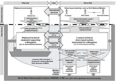
works, the figure no 2 and 3, will help to picturing the e-Navigation architecture
30
Figure 2. E-Navigation architecture (Annex 7 of NCSR 1/28 page 18)
31 Furthermore, in a real life of e-Navigation implementation, there will be ships that are
fully integrated, others partly integrated, and for a while many that are not at all. There
will be ships with SOLAS, and others with non-SOLAS. Hence, the researcher
categorized the questions in the interview into three perspectives to get clear
understanding of e-Navigation; shore, SOLAS ship, and non-SOLAS vessel.
4.2 E-Navigation. How does it work?
4.2.1 Ashore
MSC 85/26/Add.1, annex 20, point number 4, described the shore-based related part of
e-Navigation as:
The management of vessel traffic information and related services from ashore
enhanced through better provision, coordination, and exchange of comprehensive
data in formats that will be more easily understood and utilized by shore-based
operators in support of vessel safety and efficiency (p. 2).
E-Navigation requires standards and protocols that enable routing and sharing of data
between actors and infrastructures. The concept must prevent duplication of information
and ensure that the information is received in completely and reliable. Sea operations are
very sensitive in any country. Any pertinent information should be shared according to
standard operating procedures without violating any law. Accurate information is
therefore a requirement which cannot be ignored. In order for the vessel to navigate
safely, information has to be relayed from different sources. In the infrastructure ashore,
it will likely use radar, AIS, VDES LRIT, ship database, and SAR. This information
may include services for position or route advice, schedules and instructions for arrival,
pilotage and tugs service, search and rescue, maritime safety information or traffic
32 need to communicate information to control department. Regular updates are required to
ascertain security of the ship.
Moreover, e-Navigation is designed to provide 16 services that are addressed as MSP’s.
To facilitate e-Navigation ashore, collaborative maritime community systems that are
able to route information from its source and deliver to the intended users is required.
The general objective is to improve and to enhance the efficiency of the services. In
addition, the development of shore based systems towards e-Navigation has been
established prior to the SIP was conceived. For instance, few projects by the European
Community such as Vessel Traffic Monitoring and Information System (VTMIS-Net,
SafeSeaNet (SSN), Sea Traffic Management (STM) which is a project developed and
conducted by Sweden, and ACCSEAS, a 3-year project which is completed in 2015, to
name a few. These projects are aiming at enhancing the safety of maritime traffic by
minimizing navigational risk. Meanwhile, among others, in Asia Region, Republic of
Korea established the SMART-Navigation in order to implement e-Navigation on
smaller vessels. Moreover, Hong (2016) conducted a research study on the effect of
e-Navigation on reducing vessel accidents using SMART navigation concept.
These projects are in order to study and further develop the of e-Navigation services
possibilities, despite the fact that the technology keep moving on. However, the
information required will need to be integrated digitalized and be of high quality for all
stakeholders. For instance, five interviewees (35%, n=14) stated that ENC streaming
service will be considered as a reliable and resilient connectivity for the communication
link. Currently, IHO has been working to increase ENC availability and it is hoped that
the framework will be in line with the upcoming IALA standard for e-Navigation
technical services.
According to IALA (2015) report of e-Navigation architecture ENAV17-10.4.2, the
33
operation of e-Navigation. The operators and other peripheral assistants should undergo
training that would enable them coordinate the entire process with ease. (IALA, 2015).
Nevertheless, even though two interviewees indicated that the operators ashore will
likely have a different type of operator than a traditional VTS operator, most of the
interviewees are agree that HCD should provide an easy way to engage with the
operators. Since e-Navigation will be to a great extend machine to machine, therefore
the operators here will be expected to have a sufficient technical knowledge in order to
keep the competences and have capacity to deal with the new technologies and to be
able to recognize problems and act correctly, even in a case when a problem might
occurs. In the overall e-Navigation concept this is also true for the operator both ashore
and on board.
However, it seems every country will have a different arrangement regarding
e-Navigation concept (see also chapter 5!). Interviewees asserted during the interview
that some coastal states won’t be capable of afford sophisticated level of e-Navigation
information service, besides it will takes time to upgrade their systems and not every
coastal state will need to provide all MSP. Therefore, it is essential that traditional and
e-Navigation methods must be complimentary as they will have to work side by side.
4.2.2 On board
According to MSC 85/26, annex 20, paragraph 4, described on board-based related part
of e-Navigation as:
Navigation systems benefit from the integration of own ship sensors, supporting
information, a standard user interface, and a comprehensive system for managing
guard zones and alerts. Core elements of such a system will require, actively
engaging the mariner in the process of navigation to carry out his/her duties in a
34 The vessels are always in need of the latest information on board to alert the mariner
when necessary in order to ensure safe navigation. On board the vessel will likely use
official nautical charts and publications, and SOLAS standard equipment like e.g. radar,
AIS, and LRIT communications. Provision of information such as chart correction,
weather forecasts, passage planning / route advice, MSI, must enable the bridge team to
easily operate navigational equipment as well as comprehend the information that is
presented to them. More and more vessels are being equipped with IBS that provide the
possibility to route information to the consoles or equipment requiring it at specific time.
These vessels could be considered e-Navigation compliant provided there is a portal to
exchange data through a suitable data communication carrier. Beside the onboard
processes, the e-Navigation concept also contains a component that requires vessels to
provide information to other vessels and to actors ashore.
Furthermore, e-Navigation facilitates machine to machine communication which
eliminates, the certain extent, the need of human intervention. The Officer of the Watch
(OOW) is assumed in the e-Navigation environment in the future will only has to know
that the equipment is functioning and how to retrieve the data he needs from the
equipment. Because every ship has different equipment on their navigational bridge,
thorough familiarization is needed for the operator. This fact is supported by the
investigation in the project of ACCSEAS Training Needs Analysis Report (Baldauf,
2015). Further, one interviewee stated that in the future e-Navigation reality, there will
be a quality indicator to inform the mariner. So the information received can be trusted
and is correct. But when there is a conflicting information from different source, the
competence of the mariners (Master/OOW) will still be needed and especially
challenged in such cases. During the interview, it was found that the professional
judgment will be used to handle this situation which is sourced mostly from the
mariner’s experiences. If the mariners can use the data information correctly and