273 Abstract— This study aims to investigate the potentials of Varjin, a protected area near the Tehran, for implementation of indoor recreation. Existence of many natural attractive sceneries as well as proximity to the capital city of Tehran caused this region to be a suitable area for recreational purposes. For this purpose, this research identifies the ecological potential of this area in the utilization of indoor (intensive) recreation. Thus by identifying the ecological resources of the region, in a scale of 1:100000, map layers information is dispatched to the Arc GIS. Since, the implementation of recreational usage needs more variables and criterion, multi criteria evaluation method is essentially applicable. Therefore, generation of the criterion maps and their standardization are performed using fuzzy logic and S functions. Totally, 17 layers information are utilized as criterion maps for evaluation of intensive recreational potential usage. Evaluation of criteria is utilized by means of analytical hierarchy process and Expert Choice software [1].
1
Index Terms— Ecological evaluation; Fuzzy logic; Multi criteria decision-making; weighted linear combination method; Analytical hierarchy process.
I. INTRODUCTION
Unplanned and ungoverned development is one of the main problems in developing countries. To achieve sustainable development goals, evaluation of ecological capability as a basic study and foundation of land use planning, is a requisite action to accomplish development process in accordance with environmental capabilities. Besides, human-nature relation has achieved the real understanding of “human with nature” notion with gradual disappearing of old thoughts of “human on nature”. Nowadays, the idea of interactions between human and nature has been extended. These interactions have influenced different fields such as economy, social, industry, politics and culture; hence, standpoint of most of decision makers has been based on the fact that development plans do not conflict with principals of environmental protection. Emphasis on approaches such as environmental assessment and industrial
*Islamic Azad University, Assistant professor of North Tehran Branch, Tehran, Iran
1Graduate students of Environmental Science, Science and Research Branch, Islamic Azad University, Tehran, Iran
2Islamic Azad University, Shahrood Branch, Shahrood, Iran
ecology is motivation for such a modern thought. For this purpose and to reconcile human with nature, development and propagation of indoor recreation especially in the prone protected areas is one of the important actions which not only improve environmental cognition and protection culture and make economic prosperity particularly for natives, but also reduce detrimental effects on these areas, as well. Boyd et al. [2] used GIS to identify the areas suitable for ecotourism in northern Ontario. Elliott-White and Finn [3] reviewed the role of GIS for tourism marketing in the United Kingdom. Arc Objects can be used with any Microsoft component object model (COM) compliant programming Languages to develop customized GIS applications [4]. McHarg innovative systematic method has being employed manually or via computer with special corrections on a global scale in different countries and regions for many years. But at present, application of mathematical models for evaluating ecological capability is widespread. Using conceptual models in analytical hierarchy process (AHP) to assign weights and to rank expected functions as spatial choices is now propagated and recommended [5-7]. The data sets were organized into a geo database of Arc GIS as separate feature classes (equivalent to GIS map layers [8]. Although many GIS-based SDSS have been developed for various spatial decision problems in the environmental domain [9], there are only a few SDSS developed for applications related to retailing, consumer services and tourism. Ramakrishna [10] employed a conceptual model known as a Delphi survey of experts to allocate 11 functions for a micro-watershed in India. Chan and Huang [11] applied multi criteria evaluation methods to resolve contradictions between environmental protection actions and ecotourism development plans in a coastal region of Taiwan using 27 innovative parameters and two scenarios. Roger Tomlinson first coined the term of GIS in 1963 when he was in charge of the national natural resource inventory for Canada [12]. There also have been studies of GIS applications in tourism planning (e.g., [13-14]) and on delivering tourism information via the Internet (e.g., [15]). In real-world of spatial decision making situations, it would be hard to find examples of either a fully structured or unstructured problem [16]. When different people are faced with the same spatial decision problem, they are likely to place different values on variables and relationships and select and use information in different ways [17]. Decisions in natural resource management are frequently made without
Evaluation of Ecological Capability using
Spatial Multi Criteria Evaluation Method
(SMCE) (Case study: Implementation of Indoor
Recreation in Varjin Protected Area-Iran)
274 good quantitative data or the involvement of local user groups and even without explicitly addressing the multiple objectives inherent in the process [18]. Shi et al.,[19] also analyzed and evaluated the weakness and strength of ecotourism development scenarios in Shanghai suburb areas employing models based on spatial multi criteria methods through Geographical Information System. The AHP was developed by Saaty in the 1970s [20-23] as a suitable tools to multi-objective decision making where the relative values of possible decisions or outcomes were given a function value based on a mathematical representation of pair-wise comparisons. Nowadays, conceptual models in codifying and prioritizing programs, scenarios and management choices are in spread uses. Spatial analyses in the studies of determining ecological capability of lands are often Multi criteria. Decision makers and programmers confront a wide range of data and information making analyses complicated because of a large mass and distinct nature. Land suitability assessment is a severe complicated process which needs ensemble of many ecological, economical and social factors. Due to capability of Geographical Information System in collecting, saving, modifying and analyzing of data and in modeling, it is a beneficial tool for spatial programmers for multi criteria evaluation. There are several proposed methods for multi criteria analysis and evaluation of land suitability; among them Weighted Linear Combination (WLC) method is more common [16]. This method has many applications in different management branches and also in natural and environmental science because of its relative simplicity and easy implementation in Geographical Information System and also for considering knowledge and experience of analyzers and their viewpoints on importance and revision of criteria. In the current study, ecological capability and land suitability of Varjin protected area for developing intensive recreation applications has been evaluated based on weighted linear Combination method using Geographical Information System in 2008.
II.MATERIAL AND METHODS
In this research, all the maps were prepared in a 1:100000 scale using MSCD to access the mentioned map. The organization of JAHAD agriculture ministry and Environment of Iran are applied for Spatial Decision Support System (SDSS). The proceeding steps are performed as follows:
Firstly, sustainable and unsustainable resources were identified in a research scale. In addition to the preparation of
ecologic maps, the distance with main roads and population centers were also provided. Then, the classified elevation slops and aspect maps were prepared using digital elevation model applied in slop maps. Also, the criteria and variables were identified for evaluation of varjin Protected area. For standardization of the scale in map layer the fuzzy logic were used. Table 1 shows the fuzzy standardization of different criteria used for land evaluation of Varjin.
TABLE 1: EXAMPLE OF FUZZY RULES IN INTENSIVE RECREATIONAL APPLICATION CRITERIA MAPS IN DETERMINATION OF ECOLOGICAL POTENTIAL IN VARJIN PROTECTED AREA WITH A,B,C AND D S FUNCTION
Evaluation criteria
Range of values
a,
b, c d explanation
Slop (%) 0-1 10 30
For slop up to 12% equivalent 1, between 12 to 30% equivalent (0-1), more than 30% equivalent zero (0). Distance
from habitancy
(Km)
0-1 5 30
Between 5 to 12 Km equivalent 1,5 to 30 Km
equivalent (0-1)
Distance from main
roads
0-1 5 15
Distance from main road up to 5Km equivalent1,between 5
to 15 Km
geology 0-1 1 5
Alluvial land equivalent 1, sand and lime stone
between (0-1), mart stone equivalent zero.
Capability
of land 0-1 0 4
Poor pasture equivalent 1, average pasture, land with poor
capability between (0-1), agricultural land
with high and average capability, good pasture with garden capability equivalent
zero
After standardization of map layers, was assigned to each criterion the relative importance, using 9 point judgment scale (Table 2). Table 3 shows an example of AHP matrix for weighing criteria.
TABLE 2: JUDGMENT SCALE FOR PAIR-WISE COMPARISONS [23]
Descriptions Scale Equally preferred 1
275
TABLE 3: EXAMPLE OF AHP MATRIX AND WEIGHTS OF SOME CRITERIA
criteria Type of soil Diversity of animal
altitude Geographical orient
Texture of soil Final weight
Type of soil 1 5 3 1.5 5 0.0114
Diversity of animal
1.5 1 1.3 1.9 3 0.0406
altitude 1.3 3 1 1.5 3 0.0115
Geographical orient
5 9 5 1 9 0.0276
Texture of soil 1.5 1.3 1.3 1.9 1 0.0128
The calculated weighs is illustrated in Table 4.
TABLE 4: CRITERIA AND WEIGHT OF THEM IN DETERMINATION OF INTENSIVE RECREATIONAL APPLICATION OF VARJIN PROTECTED AREA
variables weight climate 0.0174 Altitude 0.0459 slope 0.1793 Geographical orient 0.0619
Type and concentration of vegetables
0.0412
Diversity of animals 0.0157 Area for animal life breed 0.0319 Ecosystem’s diversity of region 0.0612 Area for dispersion of any type of
important vegetables
0.0624
Places of any kind of wild life against threaten
0.1057
Main rivers and region runoff 0.0507 Groundwater level 0.0419
Type of Soil 0.0117
Soil texture 0.0206
geology 0.059 Distance from habitat 0.1517
Distance from road 0.0418
A. Weighted Linear Combination (WLC)
Weighted Linear Combination (WLC) technique was applied to select the best option (site), according to criteria evaluation method. The site which obtained the highest score is identified as the suitable site or class. In this method, the value of each criterion is calculated by the following equation:
∑
=
jij j
i
W
X
A
Where, Xij is the value of ith alternative towards jth
criterion, is a standardized weight as aggregation of all weights is equal to one
(
∑
W
j=
1
)
. The calculated weights showed the relative importance of each criterion and preferred alternative is selected by defining of maximum value of Ai (i =1, 2 , 3, … ,n). In this research, each criterionor sub criterion was weighing using pair wise comparison method and to selecting the preferred criteria, the preference’s value table of the Saaty is used. To ease the calculating of the weights in purpose of preference degrees and hierarchies the Expert choice software was used. To applying the weighted linear combination (WLC) method,
the following steps were performed:
• Determining of evaluation criteria collection (in form of map layers) and total score of each option
• Standardizing and converting of scale of values (evaluation criteria),
• Determining the weight of criteria i.e. weight and relative importance of each criterion and layer information
• Generation of weighting standardizing map layer
• Generation of final map usages and determining of total score overlaying maps and union function on standardized weighing map layers.
B. Providing landform units map
The landform includes natural land units that each one was transformed at the same situation of climate, erosion, weathering and earth summit and was converted to the existing form. The landform unit should be used to identify ecological resources and capability evaluation and also predict soil formation and flora of the region. On the other hand, it introduces the area's physical capability or ecosystem. The main factors to prepare landform units map of each area are slop, aspect and elevation maps that were overlaid under Arc GIS program and each unit's area were calculated. In this study using the raster calculator order totally 18561 frequent landform unit and 246 units without frequency were identified. For further use of every landform unit's information to planning of flora and wildlife habitats recovery and bonification, it was overlaid with soil map (land units), isothermal lines, isohyetal lines; flora (to determining every type's canopy) and hydrological map (to determining every hydrologic unit's runoff).
C. The conceptual model of indoor recreational use of
Varjin protected area
276 16 information layers for indoor recreation were prepared. These maps include: Absolute height, slope classifications, aspects, ground cover's type and density, faun diversity, wildlife breeding areas, ecological diversity of area, the main vegetation species, threatened wildlife species habitat, roads, settlement areas, main rivers and runoff, land farm and gardens, ground water table, soil's type and texture of area. To determine the area's capability for recreational use in addition of weighted criteria, three factors (distance from road, distance from settlement areas and distance from agricultural activities) have taken into consideration. In suggested model of this study, buffers were introduced as constraint. The constraints includes of layers which introduce absolute unsuitability of area for the mentioned land. The constraint layers have only two numbers, zero and one, so that unsuitable areas take the zero score and the suitable ones take the score one.
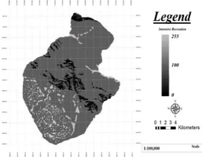
Fig. 1: The map of Varjin intensive recreation
III. RESULT AND DISCUSSION
After the allocating intensive recreational use to definite the planning units, the multi objective land allocation method (MOLA) was used. The base of this method is according to selection of the cells which have the most score for recreational use, as well as the least area. For this purpose, in regard to the parameters such as area of region, integrity and allocation, a simultaneous and multiple comparing were performed throughout the area. This stage was applied after weighing criteria as secondary weighing that have significant impact to the final result. In this research the area of each planning unit were determined in regard to the strategy of planning or aims of the study, the scale of research, ecological condition of under investigation arena, the area of the high score cells of this use, predicting the future variability of environment and also the protection level of arena. After performing the MOLA technique which was done within 19 times alternate analyses, the final maps were generated according to the proximity, size and consistency regards. At the next step, they were modified using Group, Filter and Buffer models. Totally, 19.78% of area equal to 5322.20 ha is suitable for indoor recreation (score more than 100). The result of this study showed that 7.2 ha equal to 1915.78% are recognized suitable for obtaining ideal qualification of indoor recreational use (score more than
200).
Indoor recreational Use Zone = ( 0.0418 ×[ road_e] ) + (0.0174 × [climt_e] + ( 0.0419 × [elvt_e] ) + (0.1787 × [slop_e] ) + (0.0619× [aspc_e] ) + (0.0412 × [vgty_e] ) + (0.0157 × [anbd_e] ) + (0.0319 × [anhb] ) + (0.0612× [ ecod_e] ) + (0.0624 [ vghb_e] ) + (0.1057 [ensp_e] ) + (0.0507 [wtsu_e ] ) + 0.411 [grwt_e] ) + (0.117 [slty_e] ) + (0.0206 [sltx_e ] ) + (0.590 [geoy_e] ) + (0.1517 [fhom_e] )
V.CONCLUSION
In general, ecological evaluation study, involves to multiple criteria, variables and spatial analyses. Planners and decision makers are faced with wide range of data and information to solve their problems due to different characteristic and high volume difficulties. Land suitability is a complicated process that depends on ecological and socioeconomic multiple criteria. In regard to plenty capability of GIS to solving, editing, analyzing and modeling, it is applied as a useful tool for planners in multiple criteria evaluations.
In order to complete the basic information, existing tables and maps of agricultural-Jehad ministry and environmental protection department were used. In this research, for definition of the planning units, the Multi Objective Land Allocation method was used. Totally, 19.78 % equal 5322.20 ha of area is suitable for indoor recreation purposes (score more than 100). The result of this study showed that 7.12 ha equal 1915.78 % of suitable areas for implementing of indoor recreation, have ideal situation to this use (score more than 200). The result of this investigation confirmed that natural attractive and proximity of this area to Tehran city have been high potential for developing of recreational activities and ecotourism. Unfortunately, at present many aggressions is occurred in this area due to unsuitable management and malobservation and expected opportunity in sustainable and wisely exploitation of this area treating. The Jajroud river pollution, the rapid changing of land uses, constructions and uncontrolled growth of population in area, are documents for these facts. It is suggested that, with execution of comprehensive management plan of this protected area, culturing and public awareness especially is making powerful the local communities and also cessation and serious observation of land uses changing and constructions on this protected area have been done.
REFERENCES
[1] Expert Choice, Expert Choice, Version 8.0., Expert Choice, 1992, Inc., Pittsburgh, PA.
[2] S. W. Boyd, R. W. Butler, W. Haider, A. Perera, Identifying areas for ecotourism in northern Ontario: Application of a geographic information system methodology. J. Appl. Rec. Res., 1994, 19 (1): 41–66.
[3] M. P. Elliott-White and M. Finn, Growing in sophistication: the application of geographic information systems in post-modern tourism marketing. Journal of Travel and Tourism Marketing, 1997, 7 (1): 65–84.
[4] Zeiler, M., Exploring ArcObjects. 2001,ESRI Press, Redlands, CA. [5] Thapa, R. B. and Murayama, Y. 2007. Land evaluation for peri-urban
277
[6] T. T. Duc, Multi criteria spatial decision analysis in web GIS environment. International Symposium on Geo informatics for Spatial Infrastructure Development in Earth and Allied Sciences, 2006. [7] H. C. Karnatak, S. Saran, K. Bhatia, P. S. Roy, Multicriteria Spatial
Decision Analysis in Web GIS Environment. Geoinformatica, 2007, 11, 407-429.
[8] M. Zeiler, Modeling Our World: The ESRI’s Guide to Geodatabase Design. ESRI Press, 1999, Redlands, CA.
[9] K. C. Clarke, B. O. Parks, M. P. Crane, Geographic information systems and environmental modeling. 2002, Prentice-Hall, Upper saddle River, NJ.
[10] N. Ramakrishna, Production system planning for natural resource conservation in a Micro Watershed. Electronic Green J., 2003, vol: 18, 1-10.
[11] S. L. Chan and L. Huang, A system approach for the development of a sustainable community, the application of the Sensitivity Model(SM). Environ. Manage. J., 2004, 72 (3), 133-147.
[12] R. F. Tomlinson, The Canada geographic information system. In: Foresman, T.W. (Ed.), the History of Geographic Information Systems: Perspectives from the Pioneers. Prentice-Hall, Upper Saddle River, NJ, 1998, pp. 21–32.
[13] B. Savitsky, J. Allen, K. F. Backman, The role of geographic information system (GIS) in tourism planning and rural economic development. Tourism Anal., 1999, 4 (3/4), 187–199.
[14] R. C. Mejia, N. C. de Ugarte, N. Molina, J. Indriago. Sigtur-Zulia: an application of GIS technologies for tourism planning. In: Proceedings of 2000 ESRI International User Conference. /http://gis.esri.com/library/userconf/proc00/professional/papers/PAP7 09/p709.htmS.
[15] W. Du, Y. Gabay, Scalable and interoperable tourism information system based on the Web GIS. In: Proceedings of Map Asia 2002. [16] J. Malczewski, GIS and Multi Criteria Decision Analysis, John Wiley&
sons. New York, 1999, pp: 143-151.
[17] P. Densham, Spatial decision support systems. In: Maguire, D. J., Good child, M. F., Rhind, D. W., (Eds.), Geographical information systems: Principles and applications, vol. 1, 1991, pp. 403–412.
[18] L. Fernandes, M. A. Ridgley and T. van’t Hof, 1999. Multiple criteria analysis integrates economic, ecological and social objectives for coral reef managers. Earth and Environmental Science, 18(4), 393-402, DOI: 10.1007/s003380050217
[19] C. Shi, S. M. Hutchinson, S. Xu, Evaluation of coastal zone sustainability: An Integrated Approach Applied in Shanghai Municipality & Chong Ming Island. Environ. Manag. J., 2004, 71 (4), 344-355.
[20] T. L. Saaty, The analytic hierarchy process. 1980, McGraw-Hill, New York.
[21] T. L. Saaty. Multicriteria Decision Making: The Analytical Hierarchy Process. RWS Publications, 1988, Pittsburgh, PA.
[22] T. L. Saaty, An exposition on the AHP in reply to the paper ‘remarks on the analytic hierarchy process.’ Manag. Sci., 1990, 36, 259–268. [23] T. L. Saaty, Highlights and critical points in the theory and application
of the analytic hierarchy process. Eur. J. Oper. Res., 1994, 74, 426–447.