CHRISTLETON PARISH CYCLING PLAN
Introduction
The Parish Councils of Great Boughton, Littleton, Christleton, Waverton and Huntington have joined together with a view to reducing dependence on car travel in their region of Chester. The attainment of this objective can be by an improvement in public transport in conjunction with an increase in active travel, i.e. walking and cycling. The Cycling Plan endeavours to give the Parish Councils an achievable means by which their community can become more cycle friendly. A Terms of Reference for the group developing the plan was set out initially and regular meetings have ensured the coordination of the process.
The plan covers shorter trips to access places of education, shops, workplaces, worship, recreation etc. It also considers longer routes from the community to the city centre and railway station. Hence, there are routes within the community itself and others terminating outside the community.
Consideration has been given to connectivity with established routes at adjoining parishes e.g. Vicars Cross. The emphasis is on essential routes rather than those for leisure purposes.
Parking provision for cycles is essential in order to provide security and ideally covered shelter. The plan covers existing provision and recommends where it needs to be provided or improved. The plan has been developed catering for the increased use of electric bikes. In Chester there has been a significant increase in sales of these bikes during the last year.
The plan has been sent to Sustrans to ensure that the proposals meet their much larger network objectives. It also serves a purpose for the Chester Cycling Campaign where they are surveying potential routes in the whole Chester area which are being shared with Cheshire West and Chester Council.
The Local Cycling and Walking Infrastructure Plan (LCWIP) has been developed by Cheshire West and Chester Council during the last year and has received approval by Cabinet in July 2020. There are no proposals in the LCWIP for the area covered by this plan, although residents will benefit from improvements in the town centre and near the railway station.
This report is for Christleton however should be read in conjunction with the other parish reports. At the end of the combined report there is a conclusion with recommendations for the whole area with a map showing the locations of suggested improvements to the whole area.
Methodology
The development of the plan has followed that of the LCWIP as follows – 1. Check existing provision
2. Maintenance requirements of existing 3. Establish existing cycle parking provision 4. Required cycle parking
5. Determine desire routes linking residential areas with workplaces, education, shopping, recreation, places of worship etc
6. Establish gaps or improvements for cycle routes by comparing existing with those required 7. Coordinate the cycle routes required between the five parishes to provide a coherent and
robust plan
8. Transfer conclusions to area map.
The locations of schools etc, cycle parking, and desire routes are all shown on the map here.
Existing Cycle Routes & Condition
1. CWaC’s Brown Route - passes through Christleton following the canal towpath - to the city centre on the west, and towards Waverton on the east.
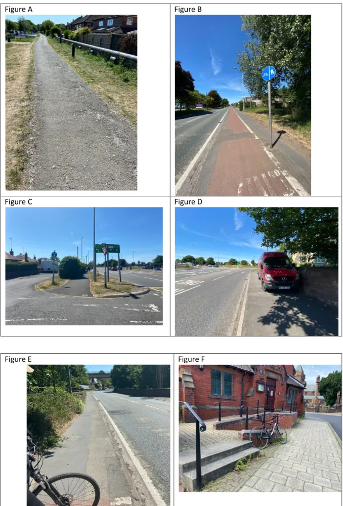
• From Christleton Lock to the A41 bridge wearing course is starting to break up (Figure A). The section from Pepper Street bridge to Christleton Lock is in reasonable condition, however has numerous potholes that require attention. The towpath towards Waverton is generally in good order however there are isolated deep potholes, which could also cause life changing injuries to cyclists.
2. The cycle path along A41 to Hamburger Junction – is in poor state of repair (Figure B). • Signage is confusing which alternates between ‘segregated’ and ‘shared’ cycle and
pedestrian use. Signage towards hamburger roundabout is particularly confusing (Figure C). • Cars are parked on the pavement forcing pedestrians into the cycle path – meaning its use is
shared even though signage suggests segregation in parts. This is most extreme with vehicles parked at the end towards the hamburger (Figure D).
• The cycle path ends abruptly over the train bridge (near Pepper Street) forcing cyclists onto the A41 (30mph but with heavy traffic in close proximity) for a short while (Figure E). The width of this stretch is 1.4m which is even more narrow than the standard width of 2m for a pedestrian footway – and certainly too narrow for dual use.
3. Route 70 ‘Cheshire Cycleway’ - a 176-mile circular journey that passes through the village following Plough Lane, Pepper Street, Canal towpath and onwards to Chester centre.
Cycle Parking Provision
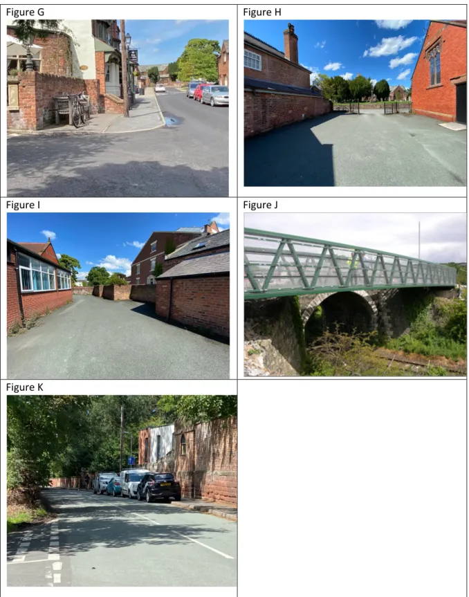
There is a lack of cycle parking provision throughout the village, with the exception of Christleton High School (where ample parking provision is made) and on-site at both the Ring O’Bells and The Plough pubs. It is common to see bikes left chained to railings (see Figure F – outside the Village Hall) and left in spaces where they cause an obstacle to others (see Figure G – bench outside Ring O’Bells – cyclist was accessing the convenience shop opposite).
Provision should be made at the locations detailed under ‘Recommendations’ section below.
Desire Lines
In determining where cycling infrastructure is needed it is necessary to establish where people need to travel. In order to focus, the routes focussed for this report are regarded as those essential for work commuting, attending high schools, shopping etc. rather than for leisure.
1. City Centre – Via canal towpath to Tesco in Chester centre.
2. Railway Station – Via canal towpath to Hoole Lane, Charterhall Drive (through bank area) direct to platform cycle park.
3. Boughton Caldy Valley Shops – Via canal towpath to A41 shared user path, Hamburger junction, Caldy Valley shared user path.
4. Hoole – Via canal towpath to Hoole Lane, Westminster Road.
5. Littleton and Vicars Cross - especially for Christleton High School students, via Village Road. 6. Waverton - especially for Christleton High School students, via Plough Lane / Brown Heath Road.
Recommendations
The following recommendations are shown graphically on the map, attached, which also covers the overall report for the five parishes. Within the confines of the Christleton Parish area, the following immediate recommendations are advised:
1. A41 cycle path improvements, between the hamburger roundabout and Pepper Street: a. A new combined cycling/pedestrian bridge alongside the existing bridge over the
railway, to provide a safe off-road path with good continuity on this key route. Required 3m wide. Example shown at Figure J.
b. Resurfacing of cycle path, full stretch between hamburger roundabout and railway bridge.
c. Improved, clear signage throughout stretch, especially nearer the hamburger roundabout.
d. Continuation of shared/segregated cycle path all the way to the hamburger roundabout, addressing the parked cars towards the corner. May involved to prohibit parking on pavement in section close to hamburger (Figure D).
2. Canal towpath maintenance.
a. Resurfacing of stretch between Christleton Lock to A41 towpath. CWaC are due to survey shortly. The section from A41 to A51 (Aldi) is believed to be resurfaced in this financial year.
b. Address potholes between Christleton and Waverton.
3. Shared user path route from A41 to Caldy Valley, via A55 underpass. The hamburger
roundabout is known to have high levels of air pollution (PM2.5, PM10 and NO2) and this route will avoid the area.
4. Little Heath Road improvements:
a. Shared user path on west side, expanding on existing pedestrian pathway.
b. Cyclist and pedestrian crossing at the duck pond, enabling those on shared user path to cross and follow along the side of the pond – towards direction of the village. This avoids the blind bend. Opportunity to address as part of Planit proposal.
5. Shared user path route from Christleton to Saighton Camp, Huntington, using the route of an existing footpath. Similar to above, this route avoids the air pollution at the hamburger roundabout.
6. Improve cycle parking provision in village – at locations below. Where possible and/or appropriate, parking should be covered.
a. Visible location outside at village businesses; possible locations include directly opposite the convenience shop, or next to the bench outside the Ring O’Bells
b. Village green/triangle (Planit asked to propose as part of redesign) c. Village Hall – ample space in the car park (Figure H and I)
d. Methodist Church e. St James Church f. Primary School
There are also a number of traffic related improvements that could improve the position of cyclists. These should be considered through discussion with Highways / CWaC.
1. Reduce 40mph speed limit along Little Heath Road, suggest to 30mph for consistency with 20 and 30mph either side of this stretch.
2. Plough Lane/Brown Heath Road junction line of sight improvement, given this spot is a known accident hotspot. This request is registered with Highways and is in their backlog.
3. Rowton Bridge Road proposed shared space with cyclists, given road is narrow and is a danger to cyclists and those walking. This is a Planit proposal for approval by Parish Council.
4. Request Highways to place the existing road ‘build-out’ in to Christleton rather than out – parked cars will then be positioned behind the ‘build-out’. Otherwise parked cars would need to be displaced. Combination of parked cars outside The Folly next to junction of Faulkner’s Lane on Pepper Street can be dangerous for cyclists, who must use road. See Figure K. This request registered with Highways and in their backlog.
Planit proposals for context
Proposals 1-5 above focus on cycling connectivity between the five Parishes which will make it easier for cyclists to access Christleton whereas the Christleton Parish Council and Planit proposals focus on making the centre of Christleton more accessible to cyclists and walkers
The proposals aim to reduce traffic speed and flow through every major route into the village so as to reduce PM 2.5 and deliver a decisive shift from use of cars to walking and cycling
We are doing this through three initiatives that we have brought together
1-the TWG recommendations of install build outs on Birch Heath Lane and Plough lane and a correction to the build out on Pepper Street
2-the Planit recommendations for Little Heath Road(rumble strip and mastic modification suggested by CWAC), the Triangle, the school entrance, the Roundel and the cycle/footpath on Rowton Bridge Road
3-a relaunch of Park and Stride
These three initiatives address two issues
1- High cut through flows to and from the A41/51
2-300 parents driving through the centre of the village and back in 25minutes to drop their children at the front gate of the school
These three initiatives will also make the village feel safer – although the accident injury rate of 1 slight injury every 20 years in in the centre of the Village is enviable
The changed approach from the North via Little Heath Road and the Triangle and the changed approach from the South via Rowton Bridge Road and the Roundel will reduce speeds/traffic flows and change the atmosphere in the centre of the village
In the simplest terms it is proposed to alter every main road in and out of the village to reduce traffic flow and speeds, change the atmosphere in the Village and cause a material shift from use of cars to cycling and walking at school drop off and pick up times and throughout the day
Little Heath Road – rumble strip and mastic finish Birch Heath Lane Build out – build out
Triangle – proposal to simplify flows and provide off street parking Pepper St – improved build out
Plough Lane junction – no priority junction Plough Lane – build out
At school drop off and pick up times we aim to move a major portion of the existing 300 movements in each direction twice a day for cars to cycling and walking
A reduction of a third of these movements every day – only 100 movements in each direction twice a day - represents 40,000 movements a year in one direction or 80,000 movements a year in both directions at school drop off and pick up time alone – when we add in the increased movements between the Parishes we expect to see a further major change in moves from car use to cycling and walking
These investments in cycling and walking within Christleton and between the Villages is interdependent
There is no point improving interconnectivity if Christleton is not attractive to cyclists and walkers AND
There is no point making Christleton attractive to cyclists and walkers if they cannot get there easily and safely
Figure A Figure B
Figure C Figure D
Figure G Figure H
Figure I Figure J