Ecologic Institute, Berlin www.ecologic.eu
International review on
payment schemes for wet
buffer strips and other types of
wet zones along privately
owned land
Thomas Dworak
Maria Berglund
Benoit Grandmougin
Verena Mattheiss
Silje Nygaard Holen
In co-operation with
ACTeon NIVA
ACT
eon
Innovation, policy, environment
Suggested citation
Dworak T.; Berglund, M.; Grandmougin, B.; Mattheiss, V.; Holen, S.; 2009. International review on payment schemes for wet buffer strips and other types of wet zones along privately owned land. Study for RWS-Waterdienst. Ecologic Institute, Berlin/Wien.
Report details
This report is a deliverable for the project “International review on payment schemes for wet buffer strips and other types of wet zones along privately owned land.”
About Ecologic Institute
The Ecologic Institute is a private not-for-profit think tank for applied environmental research, policy analysis and consultancy with offices in Berlin, Brussels, Vienna, and Washington DC. An independent, non-partisan body, the Ecologic Institute is dedicated to bringing fresh ideas to environmental policies and sustainable development. The Ecologic Institute's work programme focuses on obtaining practical results. It covers the entire spectrum of environmental issues, including the integration of environmental concerns into other policy fields. Founded in 1995, the Ecologic Institute is a partner in the network of Institutes for European Environmental Policy. The Ecologic Institute acts in the public interest; donations are tax-deductible.
Executive Summary
The Water Framework Directive (WFD) is the most substantial piece of EC water legislation to date and is designed to improve and integrate the way water bodies are managed throughout Europe. The Directive can have enormous consequences for the agriculture sector in Europe and in particular the Netherlands by requiring good status by 2015. Several new measures beyond good farming practice are required to address agricultural problems. The conversion of arable land along the various streams into more natural zones is one of these measures as it allows multiple environmental benefits.
Two kind of buffer strips exist: i) the dry buffer strip with are commonly established along water courses and will be mandatory starting 2012 (Common Agricultural Policy, Health Check), ii) the wet buffer strip more rarely implemented but which provides significant environmental functions. The following study focus on these wet buffer strip.
The conversion of riversides into wet buffer strips1 and other types of wet zones can contribute to the abatement of various water management problems resulting from current agricultural practice. Positive effects from buffer strips and even more from wet buffer strips are for example flood prevention, improving water quality, nature, landscape and sustainable energy. However, up until now not many landowners in the Europe seem interested in the various existing payment schemes to stimulate such a change.
The main focus of the study is to investigate a system of payment “euro-compatible” which could allow remunerating the farmer for the environmental services provided by the wet buffer strip.
With the scope to support the Dutch Ministry of Traffic, Public Works and Water Management in the establishment of wet buffer strips the study investigated five agri-environmental payment schemes triggering permanent land use change in 11 European countries (Austria, Belgium, France, Germany, Denmark, Luxembourg, Netherlands, Norway, Scotland, Sweden, Switzerland). The measures investigated are buffer strips, creation of wetlands, land purchase and preserving and developing nature conservation and water protection areas. In addition, case studies were carried out. In three countries (Germany, France, Sweden) case studies were carried out investigating the details behind the payment schemes as well as other factors influencing farmer`s behaviour.
From the findings it came obvious that all of the payments offered are on a voluntary basis to farmers and linked to compensation of income losses and additional work. No real payments for environmental benefits in terms of e.g. improved biodiversity, improved water quality or retention capacity where found mostly because there is no market for such services. Two main payment schemes have been identified:
• One time only payments to buy land and for investments and efforts made when converting arable area into a natural area. These payments are project based.
• Continuous payments to maintain the area converted. The main source for these payments is the EU Rural development Fund, which is co-funded by the European Commission and the Member States. Thereof measures are mostly applied on the
1
Wet buffer strips are similar to dry buffer strips in that they are strips of land alongside water courses but are either semi-permanently or permanently wet throughout the year.
national or regional level. The calculations of the amount paid to a farmer are based on income losses and changes in the amount of work. Real environmental benefits in terms of improved biodiversity, improved water quality or retention capacity are mostly not valued or considered. Denmark, Belgium and Switzerland allow for higher payments within the same measure if higher environmental goals are met (e.g. measures in areas of specific environmental interest).
As regards to continuous payments they can be considered as markets conform considering the fact that there is no market for environmental benefits. Only in Austria and Switzerland overcompensation was found for a certain measure to ensure a high level of farmer participation.
Farmer´s participation in these payment schemes is depending on several factors, which can be classified into two broad categories, namely factors which are directly linked to the setup of the payments and other factors related to farm business.
Main success factors related to the payments are:
• Compensation less than what is considered as market conform is one reason for low farmers participation;
• The funding has to be linked to distinct and understandable rules with low administrative burdens to access the money;
• Stable and long term funding in combination with a sufficient advisory service and a stable and trustful funding organisation are crucial. If funding is shared by several organisations and or administrations the “one stop one shop” principle should be applied for farmers in order to keep administrative burdens for them low;
• A high level of land use change can be achieved if the constraints for the farmer are not considered to be too strong (i.e. to shift from intensive arable land to extensive grassland) If the constraints are considered as too high even market conform payments result in low acceptance.
Important success factors related to farm business concerned are: • Size of the farm and type of the farming system
• Age of the farmer • Education of the farmer
• Type of farmer (substance, semi-substance, full time, part time, industry)
Both factors have to be considered when designing the new payment scheme in the Netherlands. Nevertheless even a full consideration of all factors does not guarantee success as the important of these single factors vary among the countries investigated and due to the fact that currently there is no “market” for environmental benefits. In the future, it will be crucial to develop schemes that better consider the environmental benefits of measures and to find ways of valuating these benefits in order to develop the current “income loss based schemes” further.
Table of Content
1 Introduction and Background ... 6
2 Nature of the present report ... 7
2.1 Main objectives and structure of the report ... 7
2.2 Main definitions used ... 7
2.3 Methodology used ... 8
2.4 Limitations of the study... 8
3 Environmental services from buffer zones in relation to water... 9
3.1 Environmental services from buffer zones... 9
4 Results from MS assessment on measures that foster a permanent land uses change towards “buffer zones”...12
4.1 Which water related measures triggering permanent land use change have been set up by MS and what environmental services do they provided? ...12
4.2 Which payment schemes are applied and on which level? ...26
4.3 What is the intuitional/legal framework behind the payments? ...29
4.4 What about participation? ...31
5 Conclusions and recommendations ...35
6 Bibliography ...37
Annex 1: Leading questions of the assessment ...39
Annex 2: Case study reports ...40
List of assessors:
Country Name
Austria Thomas Thaler, Thomas Dworak Germany (selected Länder) Maria Berglund
France Benoit Grandmougin Luxembourg Thomas Dworak Sweden Silje Nygaard Holen Norway Silje Nygaard Holen Denmark Silje Nygaard Holen UK (Scotland) Owen Le Mat Belgium (Flanders) Sophie Herbert Switzerland. Verena Mattheiss
1
Introduction and Background
The Water Framework Directive (WFD) is the most substantial piece of EC water legislation to date and is designed to improve and integrate the way water bodies are managed throughout Europe. The Directive can have enormous consequences for the agriculture sector in the Netherlands as new measures are required to address agricultural problems. Furthermore, the recent “health check” of the Common Agricultural Policy introduced a new water-related GAEC (Good Agricultural and Environmental Standards) standard to be implemented by 2012: the mandatory establishment of dry buffer strips along water to compensate for the loss of compulsory set-aside and to partly make up for losses in biodiversity and water protection. The buffer strips standard sets requirements relating to the conditions for land application of fertiliser near water courses, both within and outside vulnerable zones [designated under the Nitrates Directive 91/676]. This new standard will have further consequences for farmers in the Netherlands, as those who do not comply with the new GAEC standard can lose or receive less direct payment compensation.
The creation and management of wet buffer strips and other types of wet zones can contribute to the abatement of various water management problems at the same time, for example flood prevention, improving water quality, nature, landscape and sustainable energy. Therefore, the creation and management of wet buffer strips and wetlands can be a very interesting option. However, up until now not many landowners in the Netherlands seem interested in the various existing payment schemes to stimulate the creation and management of these wet zones.
A major problem with the implementation of buffer strips in the Netherlands, besides issues with hydrology and effectiveness, is that farmers do not want to participate because agriculture is highly productive even at field margins, land prices are high and a significant number of dairy farmers already have to export their manure surplus. Converting agricultural land into wet buffer strips may increase the total amount of manure exported. Another issue, which is not isolated to the Netherlands, is the potential reduction in direct payments farmers receive under the Single Payment Scheme (SPS) of the CAP due to the loss of eligible land area as a result of implementing buffer strips and other permanent land use changes.
However, the Dutch Ministry of Traffic, Public Works and Water Management is convinced that establishing wet buffer strips can be an interesting measure for its second river basin management plan. Therefore, the Ministry would like to know how this measure is implemented and financed in other Member States to learn how the Dutch schemes can be made more attractive to landowners (most importantly farmers).
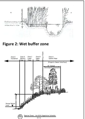
Figure 2: Wet buffer zone
Figure 2: Dry buffer zone (bergenergy.com)
2
Nature of the present report
2.1
Main objectives and structure of the report
The purpose of this project is to make an inventory of possibilities to apply economic instruments for permanently converting agricultural land into wet buffer strips or wetlands and for the maintenance of these wet zones. The inventory is based on an assessment of several European countries: Austria, Germany (selected Länder), France, Luxembourg, Sweden, Norway, Denmark, UK (Scotland), Belgium (Flanders) and Switzerland. The assessment is based on a set of particular questions (see Annex 1).
The report is structured along the following chapters:
• Chapter 1 to 3 provide the background to the study and the main definitions used. • Chapter 4 provides the main results from MS assessment on measures that foster “wet
zones”.
• Chapter 5 focuses on the main conclusions and provides recommendations to the Dutch water management authorities.
2.2
Main definitions used
The main definitions needed in the context of this study are:
• “Permanent” refers to a land use change of at least 5 years and more.
• “Land use change” refers to a change from arable land to another land use with fewer impacts on water. Operational changes in
arable management practices (e.g. introducing low fertilization, ecological farming) are not considered.
• “Buffer zone” is an area of land under permanent vegetation without intensive agricultural use. In the Netherlands two zones can be distinguished: a dry buffer zone and a wet buffer zone.
o A dry buffer zone does not need to be constructed and only requires different maintenance. On a certain width of land, no pesticides or fertilizers are applied. The dry zone is only effective on areas with no pipe drainage. A wet buffer zone is necessary in areas with pipe drainage.
o To create a wet buffer zone, the topsoil is stripped over a certain width. Wet buffer strips are similar to dry buffer strips in that they are strips of land alongside water
courses but are either semi-permanently or permanently wet throughout the year. The zone can be mowed twice a year.
Buffer zones provide different functions (see section 3.1).
• Environmental policy “instruments” are tools used by governments to implement their environmental policies. Governments may use a number of different types of instruments for example, economic incentives and market-based instruments (e.g. taxes and tax exemptions, tradable permits, and fees) but also command and control instruments (e.g. bans or regulations).
• A “measure” refers to a technical action on the ground that leads to a land use change. The implementation of measures can be triggered by an instrument.
2.3
Methodology used
The study is based on three main elements:
• A set of questions (see Annex 1) were developed to create an assessment template for identifying and understanding the Instruments provided at the national level. The template was completed by analysing relevant literature and conducting interviews. • Three local case studies investigated different payment schemes in France, Sweden
and Germany (see Annex 2). The French case study is situated in the estuary of the Seine, which is partly listed as a national Natural Reserve. The landscape is slowly transitioning from a terrestrial environment into a marine environment and contains important and specific biodiversity. The Swedish case study reviewed payment schemes for wet buffer strips and other types of wet zones along privately owned land in Halland. The German regional case study investigated the innovative approach the city of Dortmund has taken to comply with the federal nature protection act’s requirement that all construction activities causing losses to nature be compensated for.
• A broad literature review provided input concerning the question of farmer participation in voluntary agri-environmental schemes.
The findings of all these elements are combined in this summary report.
2.4
Limitations of the study
The study has some limitations, in particular regarding the term “permanent land use change”:
• Changes in land use where land still remains under “agricultural or forestry objectives” (e.g. conversion to organic farming, afforestation) were not considered. • In NL often farmers are involved in arrangements where they get compensated for
mowing later, to protect the birds in the breeding season (Weidevogelregeling). This applies to the entire pasture. This type of arrangements is excluded from the analyses, because it deals with an operational measure that can differ from one year to another.
• The specific cases of areas protected for drinking water supply are not considered. • Only voluntary schemes or schemes linked to compensation payments have been
considered. For example, buffer strips established under the Nitrate Directive or falling under the Cross Compliance Regulation were not taken into account.
3
Environmental services from buffer zones in relation to water
3.1
Environmental services from buffer zones
Ecosystems provide goods and services that contribute directly or indirectly to human well-being. Ecosystem functions are the processes and interactions (physical, chemical, and biological) that operate within an ecosystem. Ecosystem or environmental services are the beneficial outcomes resulting from ecosystem functions and can be sub-divided into 4 classes: provisioning, regulating, supporting, and cultural.2 Buffer zones can deliver the following services:
• Regulating – control water quality, natural hazard mitigation (flood prevention), soil protection and control sedimentation. Multiple studies have shown that both dry and wet buffer zones can effectively reduce diffuse nitrogen pollution in streams by removing and modifying N from agricultural runoff (Vought et al, 1995; Lowrance et al, 1995; Cuttle et al, 2007). Results from a case study in the Netherlands suggest that nitrate concentrations in groundwater decreased by 95% when it flowed through the riparian buffer zone. Denitrification rates measured in the top soil (0–30 cm) of the buffer zones varied between 9 and 200 kg N ha−1 year−1 in the forested buffer zone and between 1.2 and 32 kg N ha−1 year−1 in the grassland buffer zone (Hefting and de Klein, 1999). Corresponding Author Contact InformationEspecially the anaerobic conditions of wet buffer zones are optimal for denitrification (Lowrance et al, 1995; Noij et al, 2008). However, it should be noted that wet buffer strips are not considered as effective in reducing both pollutants from sub-surface land drainage systems (field drainage tiles) unless the system is disrupted across the buffer strip, soils are freely drained or in areas where ground water recharge is a major water transport process (SEPA BMPs Handbook, n.d.). However, the effectiveness of both dry and wet buffer strips is highly dependant on site conditions, i.e. hydrological and topographical situations, which plants are used as well as the width of the strips.
According to Scottish experiences, wet buffer strips are not effective if: a) sub surface land drainage systems (field drainage tiles) are not disrupted across the buffer strip; b) in freely drained soils pollutants are likely to pass underneath the active area of the buffer and enter the stream bed untreated and; c) in areas where ground water recharge is a major water transport process.
Riparian buffer strips are also an effective means of sedimentation control, especially when water flow is shallow and regular. However, buffer strips should not be used as a primary sediment control technology as soil conservation practices need to be in place uphill to ensure effectiveness (Eastern Canada Soil and Water Conservation Centre, n.d.).
2
As defined by: Millennium Ecosystem Assessment (2003).Ecosystems and Human Well-Being: A Framework for Assessment. Washington, D.C.: Island Press
• Supporting – wildlife habitat (in buffer strips and in water). Riparian buffer strips also provide breeding and stopover habitat for many birds as well as food. One issue, however, is that mowing and cutting these buffer strips can significantly reduce bird numbers due to the destruction of nests3. As such, the value of these zones for grassland birds is marginal (Mankin et al, 2005; Soman et al, 2007). To address this problem, some Member States require farmers to postpone mowing. For mammals, which use the areas for travel corridors, buffer strips are more beneficial. In addition, in-stream species are also positively affected. Duehr, et al (2006) found that zones with riparian buffer strips have higher macroinvertebrate and fish species richness compared to non buffered sites. • Cultural and amenity – landscape aesthetics. The visual qualities of a buffer strip make an
important contribution to the beauty of landscapes. A blighted landscape implies lack of concern for the environment. The public will frequently judge the character of a landowner by the appearance of his property.
• Provisioning – in the case of using perennial biomass crops to make bioenergy. Recently, investigations have examined the potential for planting extensive perennial biomass crops, such as perennial grasses and short rotation woody crops, in riparian buffer zones as a way to both improve water quality and to provide raw materials for bioenergy production. Similar services are provided in such zones as mentioned below but with the added benefit of provision services. Short rotation crop species with the greatest potential for rapid growth, wide adaptability, and resistance to insects, pests, and diseases are poplar (Populus spp.), sycamore (Platanus occidentalis), willow (Salix spp.), sweetgum (Liquidambar styraciflua), and maple (Acer spp.) (Koo-Oshima, n.d.).
Box 1: Ecosystem services
3
For this reason, in the Netherlands water boards are mowing only one side at a time. This leaves opportunity for birds to look for shelter on the other side.
Source: Schematic representation of the ecosystem services selected by UNEP, as categorized in the Millennium Ecosystem Assessment
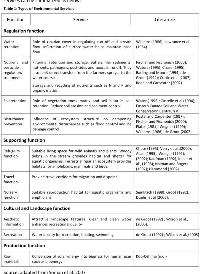
The results of classifying these above mentioned services into the concept of environmental services can be summarized as below:
Table 1: Types of Environmental Services
Function Service Literature
Regulation function
Water retention
Role of riparian cover in regulating run off and stream flow. Infiltration of surface water helps maintain base flow. Williams (1986); Lowrance et al (1984). Nutrient and pesticide regulation/ treatment
Filtering, retention and storage. Buffers filer sediments, nutrients, pathogens, pesticides and toxics in runoff. They also limit direct transfers from the farmers sprayer to the water course.
Storage and recycling of nutrients such as N and P and organic matter.
Fischer and Fischenich (2000); Waters (1995); Chase (1995); Barling and Moore (1994); de Groot (1992); Cuttle et al (2007); Reed and Carpenter (2002). Soil retention Role of vegetation roots matrix and soil biota in soil
retention. Reduce soil erosion and sediment control
Water (1995); Castelle et al (1994); Eastern Canada Soil and Water Conservation Centre, n.d. Disturbance
prevention
Influence of ecosystem structure on dampening environmental disturbances such as flood control and ice damage control
Postal and Carpenter (1997); Fischer and Fischenich (2000); Platts (1981); Wegner (1999); Williams (1986); de Groot (2002).
Supporting function
Refugium function
Suitable living space for wild animals and plants. Woody debris in the stream provides habitat and shelter for aquatic organisms. Terrestrial riparian ecosystem provides habitats for amphibians, mammals and birds.
Chase (1995); Verry et al.,(2000); Allan (1995); Wenger (1991); (2002); Kaufman (1992); Keller et al., (1993); Naiman and Rogers (1997); Hammond (2002). Travel
function
Provide travel corridors for migration and dispersal. Nursery
function
Suitable reproduction habitat for aquatic organisms and amphibians.
Semlitsch (1998); Groot (1992); Duehr, et al (2006).
Cultural and Landscape function
Aesthetic information
Attractive landscape features. Clear and clean water enhances recreational quality
de Groot (1992) ; Wilson et al., (2005).
Recreation Water quality for recreation, boating, swimming de Groot (1992) ; Wilson et al.,(2005)
Production function
Raw materials
Conversion of solar energy into biomass for human uses such as bioenergy
Koo-Oshima (n.d.)
4
Results from MS assessment on instruments that foster a
permanent land uses change towards “buffer zones”
4.1
Which water related instruments trigger permanent land use changes
have been set up by MS and what environmental services do they
provide?
What measures can be found?
Results from the assessment of selected European countries show similarities in the measures offered (see Table 2). All of these measures are voluntary. Only buffer strips have voluntary and mandatory elements.
Table 2: Overview of financially compensated measures offered in the assessed European Countries and their environmental services provided
Country Riparian Buffer Strips Wet Buffer Strips Creation of Wetlands
Land purchase for restoration of water bodies Preserving and developing water conservation areas Austria x x x Belgium X x1 x France X X x X Germany X x x Denmark X x Luxembourg x Netherlands x x x2 x x Norway X x Scotland X x x Sweden X x Switzerland X x x 1
The measure is currently only in a conceptional phase and should be implemented from 2010 onwards.
2
The measures set out in the table above can be summarised as follows:
• Buffer strips or field margins (BE, F, DE, DK, NOR, SCO, SW, CH, AT) are strips of land alongside water courses with restrictions regarding application of nutrients and pesticides and mowing times. They are mandatory under the EU Nitrates Directive and Pesticides and Biocides Directive and include restrictions in use. Several countries offer a voluntary extension of these mandatory restrictions in terms of wideness of the strip and/or restrictions to be applied. Voluntary buffer zones are established under the EU Rural Development Programs. In Dortmund, Germany, buffer strips are also established under the federal Nature Protection Act, which requires any encroachment onto nature to be counteracted. In Switzerland and Norway, these strips are regulated by national legislation as these countries are not part of the EU.
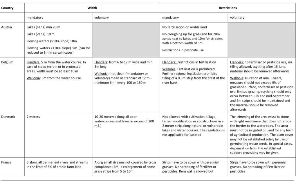
The table below gives an overview of mandatory and voluntary requirements in terms of wideness and restrictions to be applied.
Table 3: Buffer strip requirements (before the Health Check of the CAP)
Country Width Restrictions
mandatory voluntary mandatory voluntary
Austria Lakes (>1ha) min 20 m Lakes (<1ha) 10 m
Flowing waters (>10% slope) 10m Flowing waters (<10% slope) 5m (can be reduced to 3m in certain cases)
No fertilisation on arable land No ploughing up for grassland for 20m zones next to lakes and 10m for streams with a bottom width of 5m.
Restrictions in pesticide use
Belgium Flanders: 5 m from the water course. In case of steep terrain or in protected areas, width must be at least 10 m Wallonia: 6m from the water course.
Flanders: from 6 to 12 m wide and min. 3m long
Wallonia: (not clear if mandatory or voluntary) mean or standard of 12 m – minimum 6m - every 100 or 150 m
Flanders: restrictions in fertilization Wallonia: Fertilisation is prohibited. Further regional legislation prohibits tilling of a 0,5m strip from the crest of the river bank.
Flanders: no fertiliser or pesticide use, no tilling allowed, scything after 15 June, material should be removed afterwards. Wallonia: Duration of min. 5 years, measure should not exceed 9% of grassland surface, no fertiliser or pesticide use, limited grazing, scything should only occur between July and mid-September and 2m strips should be maintained and the material should be removed afterwards.
Denmark 2 meters 10-20 meters (along all open
watercourses and lakes in excess of 100 m2.)
Not allowed with cultivation, tillage, terrain modification or constructions in a 2 meter strip along natural or vulnerable lakes and water courses. The regulation is not applicable for isolated
The trimming of the area must be done with light machinery that does not erode the border to the waterbody. The area must not be irrigated or used for any form of agricultural production. The plant cover may not be established solely by use of germinating waste seeds. In special cases, dispensation from the established support provisions may be given.
France 5 along all permanent rivers and streams in the limit of 3% of arable farm land.
Along small streams not covered by cross compliance (5m) + enlargement of some grass strips from 5 to 10m
Strips have to be sown with perennial grasses. No spreading of fertilizer or pesticides. Renewal is allowed but
Strips have to be sown with perennial grasses. No spreading of Fertilizer or pesticides
without tillage. Specific restriction for livestock access to the river.
Germany (NRW)
Minimum distance of 3 meters; 1 meter in precision agriculture; 3 metres for steeply sloped land
Between 3 and 30 meters wide; grassland: 15 meters
Converting permanent grassland; the removal of trees and shrubs and new plantings; The use of chemical pesticides, unless the application of the pesticides use in this area is expressly permit; The handling of substances hazardous to water, with the exception of transport on roads; Use of fertilizers and, where necessary, the use of substances in water and in connection with approved equipment.
Strips have to be sown with perennial grasses. Buffer strips only be mowed or mulched after 15.06. No spreading of Fertilizer or pesticides. No livestock. No use beyond mowing
Luxembourg 3 meters next to waters wider than 2m in the case of arable land
arable land and grassland :
rivers, lakes > 2 m between 5 and 20 m Rivers < 2m between 3 and 12 meters
Spraying of organic fertiliser is not allowed closer than 10 meters to surface water bodies. Spaying of mineral fertiliser is only allowed if no direct contamination is possible.
Restrictions in pesticide spraying.
In the case of buffer zones that are next to water bodies larger than 2m the following restriction have been set: no ploughing up, no cultivation, no pesticides, no fertilisation, no over seeding, no changes in drainage. Bordering meadows have to be fenced and limitations in mowing. Restrictions in live stock density. The water authorities can include additional restrictions (change to fallow land) on certain water bodies
Netherlands Next to most waters: 0.25 to 5 meters depending on crop and pesticide used and method of pesticide spraying. Grassland 25 cm, cereals 25 cm, potatoes 150 cm, vegetables and bulbs 150 cm, orchids 5 meters
Along natural waters on sandy soils 5 meters
Arable land and grassland no restrictions on width. Mostly between 3.5 – 6 meters
no fertilizers and manure; no pesticides Grassland: No damage due to grazing and other agricultural practises. No
mechanical and chemical weed control, with the exception of spots of certain noxious weeds
Arable land: see grassland. No or only light fertilization. Vegetation cover (grass, mixtures of herbs, cereals etc.) depends on purpose.
Maintenance (mowing etc, depends in environmental goals)
Length has to be 25 meter
Norway 2 meters to get the full size production subsidy from the State. (§ 8 in the regulation of production subsidies).
minimum 6 meters wide No cultivation. For area with erosion risk in the catchment of a vulnerable watercourse, the county governor can set regional requirements to tillage practices or other measures.
Covered with grass by early autumn. No phosphorus fertilizer and maximum 10 kg nitrogen/decare. Area has to be harvested. Grazing is allowed if the tramples do not lead to the damages and erosion. Tillage is only allowed when recondition of the grass cover is necessary. Not more frequently than every five years. If area is reconditioned, it is not allowed to fertilize the area before the first of March the next year.
Scotland (See also Box 3).
2 m wide between a river or a loch and an arable field
12 -24 m in the case of still water; 12 m for watercourses; Steep ground or existing semi-natural habitat: 20m
No fertilizer in NVZ To maintain a sward at a range of heights, to control grazing to avoid poaching of the ground, to maintain a close graze in late summer with a height between 10 and 15 cm, no application of fertilisers (including slurry and manure), control of invasive/non native species, no cultivation of the buffer strip, no reinforcement of the banks, no new draining.
Sweden Only voluntary At least 6 meters broad but maximum 20
meters
Only voluntary The length has to be at least 20 meters. The use of fertilisers or plant protection products is prohibited in the riparian strip.
Switzerland (See also Box 2.)
3 meters At least 3 m along bank vegetation or 6 m
along surface water bodies
No pesticides or fertilizers alongside surface water bodies.
Mowed at least every three years, but not before the 15th of June (or later,
depending on the area). No use of fertilizers or pesticides is allowed on the first 3 m. In the case of surface water bodies, no use of pesticides is allowed until the 6th meter.
As the table above illustrates, mandatory and voluntary requirements vary greatly among European countries. Minimum mandatory width requirements range between 0,25 meters (when using precision agriculture) to 5 meters. Most voluntary width requirements set a maximum limit of around 20 meters; Scotland sets a limit at 24 meters and Germany at 30 meters. All of the countries do not allow the application of fertilizers and plant production products on voluntary strips, while only some countries include requirements regarding mowing times and the sowing of perennial crops.
A distinction between wet and dry strips is only made in Scotland and Switzerland. In Scotland this measure refers to “Buffer Areas for Fens” and “Lowland Raised Bogs”. In such cases, beneficiaries must ensure that the surrounding area is managed as a grass buffer (10 meters in width) and that field drains and culverts are disconnected. In Switzerland, the only other country assessed where this measure is offered, “Streueflächen” are wet or humid areas which are mowed every one to three years with the cut material being removed. No use of pesticides and fertilizers is allowed. Mowing can only take place after the 1st of September. After their registration, areas have to be managed in the same way for at least six years.
Box 2: Width of buffer strips along surface water bodies in Switzerland
In Switzerland, mandatory requirements according to the Chemicals-Risk-Reduction Decree ban the use of fertilizers within a width of at least 3 meters along surface water bodies and the use of pesticides within at least 6m. According to the morphology of the river bank, those distances are measured differently. Three examples are shown below.
a) Small river with the slope of the bank lower than 50%:
No fertilizers No
fertilizers
Fertilizers allowed Fertilizers allowed
Grass strip No pesticides Grass strip No pesticides
b) Small river with the slope of the bank steeper than 50%. The width of the buffer strip is measured from the upper edge of the embankment:
Grass strip No pesticides Grass strip No pesticides No fertilizers No fertilizers
Upper edge of embankment Upper edge of embankment
c) Buffer strip along surface water bodies with bank wood. For surface water bodies with hedges / bank wood, the 6 meter distance is measured including the wood from the border of the water body, independent from the slope. The 3 meter strip without fertilizers is measured from the border of the wood.
Fertilizers allowed Fertilizers allowed No fertilizers No fertilizers No fertilizers No pesticides No pesticides
Independently from these mandatory buffer strips, two curves have been developed indicating the minimum width of buffer strips which a) assures the protection against inundations and the maintenance of ecological functions as well as b) the width which ensures biodiversity conservation. The curves only provide recommendations, but efforts are made to attain them in river restoration projects. The curves are shown in the figure below:
Natural width of the river bed in meters
Curve allowing to determine the optimal minimum width of the buffer strip
W id th o f th e b u ff e r st ri p in m e te rs (o n e s id e )
Sources of the figures: Office fédéral des eaux et de la géologie (2000) « Réserver de l’espace pour les cours d’eau »,Bern, Switzerland (adapted); Furer et al. (2009) « Pufferstreifen – richtig messen und bewirtschaften », KIP & PIOCH (ed.), Lindau and Lausanne, Switzerland (adapted)
Box 3: Wet Buffer zones in Scotland
In Scotland strips of natural or naturalised wetland vegetation or woodland, usually ranging from 1-50 m wide, are situated alongside watercourses, particularly small streams. There is no definitive width for these strips, although there is little evidence that strips less than 5 m width have any effect. The size depends on the vegetation, slope and soil type.
All land managers are eligible to apply for compensation but have to enter a 5-year commitment. £267.90/391,13 Euro per hectare per year for land managed under this option are paid. Payments are paid at the end of each year. The payments can be obtained in addition to any payments from managing the fen or lowland raised bog area in accordance with the Management of Wetlands Option or the Management of Lowland Raised Bog Option'
Beneficiaries must comply with the requirements of cross compliance and the minimum requirements for fertiliser and plant protection products. Furthermore, land owners must also comply with the requirements to avoid damaging any features of historic or archaeological interest and follow Scottish Ministers' guidance for the protection of such areas or features.
• Creation of Wetlands (AT, BE4, DE, DK, NOR, SCO, SW, F): Wetlands are understood as an area covered with vegetation where the water tables during most of the year is under or close to the land surface and where the level is permitted to fluctuate according to seasonal variations. To be eligible for compensation, an established or restored wetland must be preserved for at least 5 years (AT, DE, SCO, NOR) and up to 15- 20 years (DK, F, SW). By mowing and allowing grazing on wetlands and their borders for a period of five years, farmers are eligible for payment as well. During the rural development programme period 2007-2013, there will be possibilities to extend the 10 year contracts agreed in the last programme period for another 10 years (Sweden). In France, this measure often appears when new infrastructure is constructed on a wetland area (e.g. roads). In that case the investor should compensate its environmental degradation by purchasing land and creating new wetlands. In Austria, wetlands are funded through a national action program for hydro-morphological measures.
• Land purchases (AT, BE, F, DE, CH) are undertaken for various reasons by the countries assessed. Austria uses its national action programme for hydro-morphological measures to also purchase land to create wetlands, re-meander surface waters and implement buffer strips. France has included this measure in its dRBMP to buy wetlands from farmers. Following purchase, farmers may lease the land but under certain restrictions for environmentally friendly farming. For example, the government funded Conservatoire due littoral (Coastal protection agency) has purchased over 1500 ha since 2000 in the Seine river estuary. In Germany, measure 323 “Conservation and upgrading of rural heritage” under axis 3 in Lower Saxony enables, among others, to acquire agricultural land in drinking water zones to ensure water quality. Extensive or organic agriculture is, however, still allowed.
4
The measure is currently only in a conceptional phase and should be implemented from 2010 onwards. Contractual payments will be considered case by case.
• Preserving and developing nature conservation and water protection areas (AT, F). In Austria, this measure is subsidized by the Rural Development Programme with the aim to reduce the use of pesticides and fertilizers in agriculture cultivation. This is achieved through promoting the conservation of water-related landscape elements such as wetlands, seasonally wet meadows and ponds as well as through land set-aside.
What environmental service do the different measures provide?
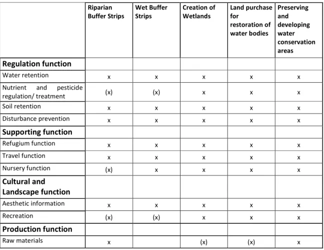
The different measures provide different environmental services as shown in the table below:
Table 4: Provision of environmental services Riparian Buffer Strips Wet Buffer Strips Creation of Wetlands Land purchase for restoration of water bodies Preserving and developing water conservation areas Regulation function Water retention x x x x x
Nutrient and pesticide
regulation/ treatment (x) (x) x x x Soil retention x x x x x Disturbance prevention x x x x x Supporting function Refugium function x x x x x Travel function x x x x x Nursery function (x) x x x x Cultural and Landscape function Aesthetic information x x x x x Recreation (x) (x) x x x Production function Raw materials x (x) (x) x
X= full support (x) limited support
As one can see, the differences between the different measures in terms of environmental services provided are limited. In practice, the level of service provided strongly depends on the area covered and the level of restrictions applied. Higher restrictions in use (limits in mowing) will reduce, for example the production of raw material but will increase the refugium function. Therefore, when setting up new measures it should be clear which functions have the highest priorities. Restrictions as well as area to be covered should be aligned along these priorities.
What are the main pressures addressed?
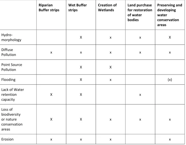
The following table provides an overview of the link between a certain measure and the pressure/s they address:
Table 5: Pressures addressed by the various measures Riparian Buffer strips Wet Buffer strips Creation of Wetlands Land purchase for restoration of water bodies Preserving and developing water conservation areas Hydro-morphology X x x X Diffuse Pollution x x x x x Point Source Pollution X X Flooding X x (x) Lack of Water retention capacity X X x Loss of biodiversity or nature conservation areas X X x x x Erosion x x x x
X= full support (x) limited support
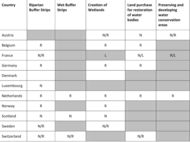
What is the level of implementation?
The level of implementation refers to the level where the measure is offered to the target group, not to the level where the measure in fact is implemented on the ground. As shown in the table below, the level of implementation of voluntary measures varies among the Member States and is largely a result of whether they have regional or national rural development programmes. Austria, Belgium and Germany both have regional programmes, while Scotland, Sweden, Denmark and France have national plans. However, France also implements some agri-environmental measures at regional level. In Germany each “Land” has set up its own agri-environmental programme and in the Netherlands provinces and water boards are responsible.
Table 6: Level of implementation of voluntary measures Country Riparian Buffer Strips Wet Buffer Strips Creation of Wetlands Land purchase for restoration of water bodies Preserving and developing water conservation areas Austria N/R N N/R Belgium R R R France N/R L N/L R/L Germany R R R Denmark Luxembourg N Netherlands R R R R R Norway R R Scotland N N N Sweden N/R N/R Switzerland N/R N/R N/R
N =national level R=regional level L= Local level. The grey cells indicate the measure is not offered.
What is the target audience of the measures?
Most of the measures exclusively target farmers. Land purchases can also be undertaken by local communities and public entities, for example in Austria, France and Germany. Additionally, in Scotland, Sweden and Denmark land owners who do not farm on their land can also apply for payments for buffer strips and the creation of wetlands.
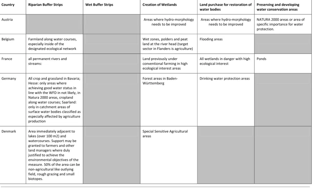
What is the area targeted
Voluntary measures can be targeted either generally or can include specifications on priority areas for implementation. For buffer strips beyond the requirements set out under the Nitrate Directive, and considering the situation before the health check of the CAP5, the common requirement in the MS analysed are that strips need to be planted along water courses; in Hesse (Germany) implementation of strips is a priority near water bodies not in line with WFD objectives and in Scotland the priority is to plant strips near water courses high in diversity. The creation of wetlands in all MS should take place on former agricultural
5
The Health Check has resulted in changes to both the Statutory Management Requirements (SMRs) and the standards defined for Good Agricultural and Environmental Condition (GAEC). Two new issues focus on water management, whilst a new compulsory GAEC standard requires Member States to introduce a standard for buffer strips next to watercourses. Member States have until 2012 to introduce an appropriate standard.
or forestry areas; France and Denmark target sensitive areas with high ecological interest. Areas targeted for land purchases vary among the Member States.
Table 7: Land type targeted by the selected voluntary measures
Country Riparian Buffer Strips Wet Buffer Strips Creation of Wetlands Land purchase for restoration of
water bodies
Preserving and developing water conservation areas
Austria Areas where hydro-morphology
needs to be improved
Areas where hydro-morphology needs to be improved
NATURA 2000 areas or area of specific importance for water protection.
Belgium Farmland along water courses, especially inside of the designated ecological network
Wet zones, polders and peat land at the river head (target sector in Flanders is agriculture)
Flooding areas
France all permanent rivers and streams:
Land previously under conventional farming in high ecological interest areas
All wetlands in danger with high ecological interest
Ponds
Germany All crop and grassland in Bavaria; Hesse: only areas where achieving good water status in line with the WFD in not likely, in Natura 2000 areas, cropland along water courses; Saarland: only in catchment areas of surface water bodies classified as especially affected by agriculture production
Forest areas in Baden-Württemberg
Drinking water protection areas
Denmark Area immediately adjacent to lakes (over 100 m2) and watercourses. Support may be granted to farmers and other land managers where duly justified to achieve the environmental objectives of the measure. 50% of the area can be non-agricultural like outlying field, rough grazing and small biotopes.
Special Sensitive Agricultural areas
Luxembourg Arable and grass land next to water courses
Netherlands Arable and grassland next to water courses
Arable and grassland next to water courses
Ponds to enhance biodiversity flood control, biodiversity, water quality
Natura 2000; drinking water
Norway Along open trenches, streams, rivers or lakes
Former agricultural production area
Scotland In-bye land bordering
watercourse having a bed width of at least 0.6 metres which: a) supports species rich grassland, fen communities (dominated by sedges, rushes, reeds or meadowsweet) or riparian woodland, or b) borders, improved grassland, or arable (sites with low natural heritage interest are eligible where there is the potential to reduce diffuse pollution)
Improved in-bye (including areas of rush pasture) or arable land surrounding a fen or lowland raised bog.
Arable land or improved grassland where the raised water levels resulting from creation of wetland would not adversely affect other land, cause the erosion of river banks or be liable to cause damage to archaeology
Sweden Arable land Arable land, pasture and other
land
Switzerland All areas next to bank vegetation All wet and humid areas Area chosen by cantons (no land types mentioned)
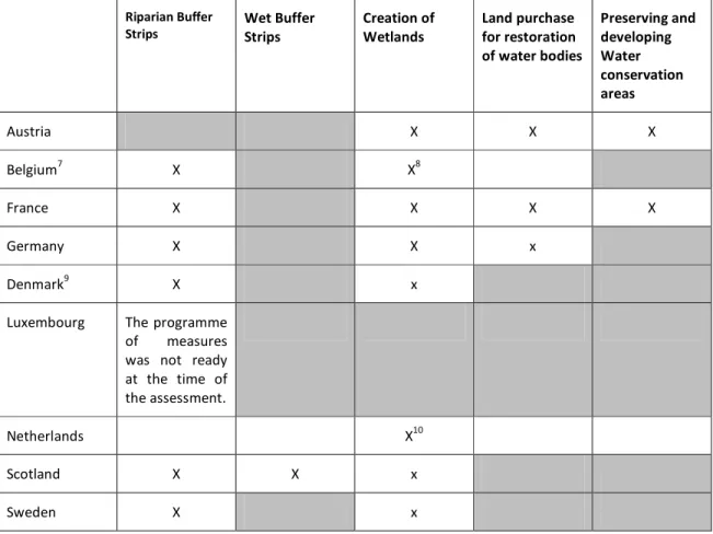
Are these measures part of the dRBMPs?
Although the river basin management plans and their programme of measures are still in the drafting phase, some EU Member States have detailed which supplementary measures will be included in their plans6. However, which measures will be included in the final versions is not known at this time.
Table 8: Voluntary measures included in the draft River Basin Management plans of the EU countries
Riparian Buffer Strips Wet Buffer Strips Creation of Wetlands Land purchase for restoration of water bodies Preserving and developing Water conservation areas Austria X X X Belgium7 X X8 France X X X X Germany X X x Denmark9 X x
Luxembourg The programme of measures was not ready at the time of the assessment.
Netherlands X10
Scotland X X x
Sweden X x
The grey cells indicate the measure is not offered.
4.2
Which payment schemes are applied and on which level?
What type of payments can be found?
Two main calculation schemes have been identified:
• One time only payments for investments and efforts made when converting arable area into a non-arable area. These payments are mainly used to buy land from farmers (e.g. to establish a wetland) and are project based.
6
Norway and Switzerland are not obliged to draft River Basin Management plans as they are not governed by EU legislation.
7
Part of Sigmaplan (Flood protection plan with links to the RBMPs). Measures currently not applied.
8
Mandatory measure in Flanders
9
Part of the Aquatic Environment Plan III
10
• Continuous payments to maintain the area converted. These payments are based on average rates with the aim to compensate for income forgone and/or the extra effort resulting from implementation. Not all countries use the same cost categories in their calculations (e.g. labour costs are not always considered). The former crop mix (e.g. high value crops, perennials) is often considered when calculating different levels of payments.
Box 3: Payments for the voluntary set up of buffer strips
Buffer Zones (BE, DK, F, GER, LUX, NL, NOR, SCO, SW, CH): The payments are always continuous and based on size. The amount paid varies widely among the different states assessed, as shown in the diagram below. This can be partly explained due to the different restrictions that farmers have to
comply with, but also due to different calculation methods or overpayments (see below).
In all countries assessed, the payments for maintaining the land use changes are linked to minimum years of compliance (5-7 years). Farmers have to enter contracts ensuring this “long term” participation.
Are extra payments possible when different environmental aims are met?
It is important to distinguish between extra payments possible when different environmental aims are met and a combination of different payments on the same area. While combining different payments is common under the EU Rural Development Programs, other payment plans take into account different levels of environmental services provided. Within the assessed countries, the following examples have been found:
• When establishing buffer strips in Belgium, more money is given if nature management is included11 or if the area is within the ecological network (20% more).
11
A similar approach was found in Switzerland where higher compensation is paid if the buffer strip is implemented in areas of particular biological quality and for linking areas.
Box 4: Example from Switzerland
In the Swiss context, certain types of agricultural areas, including buffer strips, can be counted as ecological compensation areas. Those areas must encompass 7% of the total agricultural area of the farmer if s/he wants to benefit from agricultural direct payments. In addition, some types of ecological compensation areas are eligible themselves for financial compensation. Furthermore, certain criteria have been defined which make the same area suitable for additional payments according to the Swiss Decree on ecological quality. Those criteria include – according to the type of the area –the occurrence of certain indicator species or the absence of exotic species. As a third element, the area can be registered in a biodiversity network. Also in this case additional payments for the same area are possible. The total payments for the different areas are illustrated in the table below. The amounts given correspond only to the payments available in the lowland areas.
Ecological compensation
areas
Decree on agricultural direct
payments Decree on ecological quality Law on nature protection and landscape Counting as ecological compensation area Financial contribution Payments for ecological quality
Payments for the participation in a biodiversity network Meadows and pastureland C a n g iv e t h e r ig h t to fi n a n ci a l co m p e n sa ti o n s - d e p e n d in g o n t h e c a n to n Extensive
meadows x 1500 SFr/ha 1000 SFr/ha 1000 SFr/ha Low intensive
meadows x 300 SFr/ha 1000 SFr/ha 1000 SFr/ha Litter areas x 1500 SFr/ha 1000 SFr/ha 1000 SFr/ha
Extensive
pastureland x 500 SFr/ha 500 SFr/ha
According to the table above, for example, one hectare of litter areas, which are by definition wet areas, can receive financial contributions up to 3500 Swiss francs if the area complies with ecological quality criteria and is registered in a biodiversity network.
• Denmark provides additional support for supplementary conservation obligations related to grazing and mowing with respect to the creation of wetlands.
• In Austria payments for preserving and developing water conservation areas are higher if farmers combine the measure “Preserving and developing Water conservation areas“with organic farming.
The limited examples of staggered payments found in the assessment can be explained by the fact that agri-environmental measures under the Rural Development Programs already have multiple environmental objectives such as water protection, soil erosion, conserving biodiversity. Therefore, the restrictions and limitations linked to the measures are already designed to serve these multiple objectives. So, the payments designed along the losses or the extra work a farmer has due to the restrictions/limitations already consider these multiple objectives.
Are payments market conform?
In most cases the continuous payments can be considered as markets conform. Only in Denmark and in some federal states in Germany (e.g. Bavaria) lower rates are paid, while
Austria overcompensate a certain measure – see box below. In most cases no extra payments for individual measures are possible when different environmental aims are met. Exceptions are Baden Württemberg, Germany for conversion to grassland. However, a combination of measures is often possible, which leads to higher environmental standards and payments for the farmer (e.g. Austria).
Box 5: State Aid rules for compensation of voluntary rural development measures
Compensation for agri-environmental measures going beyond the maximum set out in the Annex of EC Regulation 1698/2005 is allowed under State Aid rules if it is duly justified (Article 88(4)). Further, Article IV.C.2.b of the EC Guidelines for State Aid in the Agriculture and Forestry Sector 2007 to 2013 clarifies that higher support levels can be accepted for commitments which entail a real change of current agricultural practice, leading to demonstrable positive effects on the environment
Overcompensation for measures included in the Rural Development Programmes is currently practiced in Austria for preserving water protection areas and in Luxembourg for the implementation of buffer strips. While normal rules for calculating payments apply (i.e. extra costs and income forgone), overcompensation is allowed if sufficient justification is stated, such as multiple benefits, current low acceptance of farmers should be increased or overcompensation already occurred in the previous programming period. While usually national sources are used to compensation this measure, the EU will also co-finance if the payment is duly justified.
In the case of Austria, overcompensation is justified due to low acceptance of the measure by farmers, multiple environmental benefits of the measures (improvement of water quality, benefits for biodiversity), current low acceptance of farmers should be increased and by the fact that the measure has been already applied in former RD programs.
How much money is available in total?
The total budgets available for the measure are not available in most cases. A judgment on the importance of the measure in relation to either the payments under the Rural Development program or the costs of the program of measures is not possible.
Are there payments for exit strategies?
No examples where farmers get paid at the end of the contract to turn their land back to its original state (i.e. make it suitable for (intensive) agriculture) were found. In fact land conversions funded under the Rural Development period 2000 to 2006 have been continued to be funded under the current RD period (2007-2013). Farmers were able to renew their contracts.
4.3
What is the intuitional/legal framework behind the payments?
National level
The countries assessed that are within the European Union follow a similar institutional framework for the mandatory and voluntary measures they offer. Mandatory requirements regarding the spreading of nutrients and pesticides along water courses are a result of various EU directives12, implemented across the whole territories of Austria, Denmark,
12
Council Directive 80/68/EEC of 17 December 1979 on the protection of groundwater against pollution caused by certain dangerous substances; Council Directive 86/278/EEC of 12 June 1986 on the protection of the environment, and in particular of the soil, when sewage sludge is used in agriculture; Council Directive 91/676/EEC of 12 December 1991 concerning the protection of waters
Germany, Luxembourg, France and the Netherlands, which must be adhered to in order to receive direct payments under the first pillar of the EU Common Agriculture Policy.
The main legal mechanism for the voluntary measures identified is the EU Rural Development Regulation under pillar 2 of the CAP. This regulation is transposed into national law and implemented either through national or regional rural development programmes. France and Scotland take a similar approach in that the national government is responsible for managing and controlling programmes and provides the strategic overview of implementation. It is also responsible in both countries for payments. Regional committees, which are composed of representatives of national and local governments as well as local independent agencies, aid the national committee. Since Germany is a federal state, regional ministries of agriculture are responsible for program design and coordinating the overall program in terms of implementation, financial management, monitoring, assessment and reporting. Implementation of measures is coordinated by subordinate offices, such as Offices of Rural Studies (ÄLR), State Environmental Offices (StUÄ), State Agencies for Nature and Environment (LANU) and Land Agencies.
In addition to the Rural Development Regulation, the draft river basin management plans the programme of measures also contain voluntary measures for different sectors within the EU. Management and implementation of these plans and programmes will occur at the regional basin level once they are implemented in 2010. Relevant authorities will be ministries of environment or public works (in the case of NL) as well as regional and local Water Boards or agencies. The Flemish Flood Plan (Sigmaplan) also contains a number of measures, which are regulated by the Agency for Nature and Forestry within the Ministry of Environment.
In Germany the National Nature Conservation Law requires citizens to refrain from unnecessary activities resulting in the deterioration of nature and landscape. Any encroachments (e.g. setting up new roads or housing areas) must be counteracted through nature conservation measures and landscape management (compensatory measures) or offset in other ways (substitute remediation). An encroachment is considered compensated when the impaired ecological functions and landscape are restored. This normally requires the buying of land for the construction company. A specific case of this payment system is described in the German case study.
In Luxembourg the revenue from selling fishing rights is used to fund specific hydro-morphological projects such as wetland creation. However, the total amount of the revenues is rather limited compared (about 100.000/year) to the rural development fund.
Although there are few formal links between EU agriculture and rural development policy and water management policy and policies of Norway and Switzerland, many of the policy objectives (e.g. multifunctional and sustainable agriculture throughout the territory, high water quality) and approaches taken to implement these objectives are similar.
To achieve environmental objectives, farmers and land owners in Norway have to meet national and regional legal requirements. Similar to the EU cross compliance regime, at national level Norwegian farmers have to meet the environmental requirements laid out in §
against pollution caused by nitrates from agricultural sources; Upcoming Directive on the Sustainable Use of Pesticides revising Council Directive 91/414/EEC of 15 July 1991 concerning the placing of plant protection products on the market
8 of the Regulation on production subsidies in order to get the full amount of direct payments from the State. Among others, this includes mandatory minimum requirements for buffer zones situated alongside water courses. Each county also has its own environmental programmes as well (Landbruks- og matdepartementet 2009). The County Governor`s office is responsible for the establishment of payment schemes to achieve environmental goals and the municipalities are the decision authority, and consider and decide on applications for funding, for example for the establishment of wet zones.
In Switzerland, the system of direct payments and payments for voluntary activities to achieve environmental goals is largely administered at a regional level. Farmers receiving direct payments for ecological compensation areas have to register their applications with the cantons, which determine whether they are eligible or not. However, actual payment is controlled at national level by the federal agency, which controls the payment list of the canton and then transfers the total approved amount to the cantons. The cantons pay the farmers and carry out monitoring activities. Concerning additional payments linked to ecological compensation areas of particular biological quality and for linking areas (according to the decree on eco-quality), the federal state finances only 80%. The rest has to come from cantons, municipalities, private persons or other funding bodies (ÖKV, BLW 2008).
The Swiss water legislation (Schweizer Wasser- und Gewässerschutzgesetzgebung) regarding the conservation of water bodies and water related ecosystems takes a similar “overall concept watercourses” (“Leitbild Fliessgewässer”) as the EU Water Framework Directive and has the same objective to ensure the natural functions of water bodies but has only a recommendatory character (Rey & Müller 2007).
Local level
In addition to national level payments, local funding sources are often mobilised. In France (see case study Seine River) revenues from a tax on leisure boat permits is used to fund certain land purchase projects. In Austria in some Länder specific funds for improving landscape ascetics have been created (fed by local tax income). These funds also include payments for improving hydro-morphology. In Germany in several Länder so called “co-operative agreements” between drinking water companies and farmers exist. In these cases, the drinking water companies pay farmers to protect the water. The main focus of this payment scheme is clean drinking water and not other environmental benefits.
Further, in most EU countries municipals are also providing funding in the case of specific projects.
4.4
What about participation?
The level of farmer participation is not known in most countries analysed in the context of this study. This can be explained by the fact that there is no public access to the Rural Development Database each EU Member State has to maintain in order to fund farmers. However, based on the interviews carried out in the context of the study, there is a strong sign that farmer participation is not high with respect to implementing permanent land use changes.
Besides identifying the level of participation, one objective of this study was also to investigate the factors for farmers’ participation and to develop recommendations to the