APPENDIX E
REAL ESTATE PLANNING REPORT
SECTION 107 NAVIGATION IMPROVEMENT PROJECT - GREAT CHEBEAGUE ISLAND
CUMBERLAND COUNTY, MAINE
U.S. ARMY CORPS OF ENGINEERS REAL ESTATE DIVISION NEW ENGLAND DISTRICT
696 VIRGINIA ROAD CONCORD, MASSACHUSETTS 01742-2751 Prepared by: Pamela S. Bradstreet Realty Specialist EFFECTIVE DATE: AUGUST 2020
TABLE OF CONTENTS
1. PROJECT PURPOSE E-1
2. PROJECT AREA DESCRIPTION E-2
3. RECOMMENDED PLAN E-3
4. REAL ESTATE MAPPING E-5
5. RECOMMENDED ESTATES E-5
6. EXISTING FEDERAL PROJECTS E-6
7. EXISTING FEDERALLY OWNED LANDS E-6
8. LANDS OWNED BY THE NON-FEDERAL SPONSOR E-6
9. NAVIGATION SERVITUDE E-6
10. INDUCED FLOODING E-6
11. BASELINE COST ESTIMATE FOR REAL ESTATE E-6
12. PUBLIC LAW 91-646 RELOCATIONS E-6
13. MINERAL ACTIVITY E-6
14. TIMBER RIGHTS E-7
15. ASSESSMENT OF NON-FEDERAL SPONSOR ACQUISITION CAPABILITY E-7
16. ZONING E-7
17. ACQUISITION SCHEDULE E-7
18. UTILITY AND FACILITY RELOCATIONS E-8
19. HAZARDOUS, TOXIC AND RADIOACTIVE WASTE E-8
20. ATTITUDES OF THE LANDOWNERS E-8
APPENDIX E
REAL ESTATE PLANNING REPORT
1. PROJECT PURPOSE
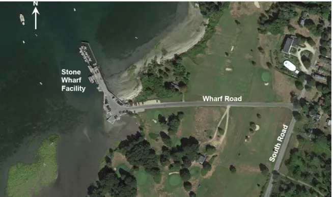
The purpose of the Great Chebeague Island Project is to improve the existing navigation conditions at Stone Wharf on Great Chebeague Island by creating a new channel. Shallow water hinders operation of many activities that rely on landing at the Stone Wharf. As the Island’s principal landing, public safety, the island economy, and island services, all depend on adequate access to the mainland over the Stone Wharf. The project is designed to correct this problem. In addition, the Real Estate Plan is to support the Section 107 Navigation Improvement Project, Great Chebeague Island, Maine.
Figure E-2 – Aerial View of Stone Wharf
2. PROJECT AREA DESCRIPTION:
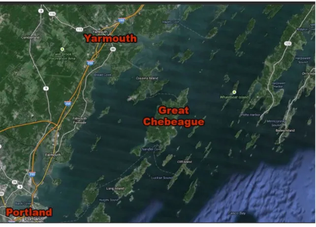
The Town of Chebeague Island is a municipality consisting of 17 islands in upper Casco Bay, Cumberland County, Maine approximately 10 miles north of Portland, Maine. Two of the town’s islands are inhabited, of which Great Chebeague is the largest. The town is isolated with no bridge access to the mainland. The principal town landing is at the Stone Wharf on the northwest shore of Great Chebeague Island. All goods are transported by barge to the island. There is year-round barge and ferry service for passengers and light cargo from nearby Cumberland. Vehicles, fuel, trash, seafood, utility service, and building materials are carried by barge. Approximately 350 people live year-round on the island, with approximately 1,700 summer residents. The principal commercial activity is fishing, with about 44 vessels licensed primarily for lobstering and another 19 vessels used for freight and passenger transportation.
In 2003, the Town of Chebeague Island applied for and received a permit to dredge approximately 300 feet by 150 feet adjacent to the wharf to a depth of 8 feet below mean lower low water (MLLW) with an allowable overage of one foot. Approximately 6,000 cubic yards of material were removed. In October 2009, the Town of Chebeague Island requested the USACE revisit the feasibility and Federal interest in the
improvements proposed in the 1973 USACE navigation improvement report for improving the navigation conditions at Stone Wharf.
Great Chebeague Island, ME
§107 Navigation Improvement Project
______________________________________________________________________________________ Appendix E - Real Estate November 2020
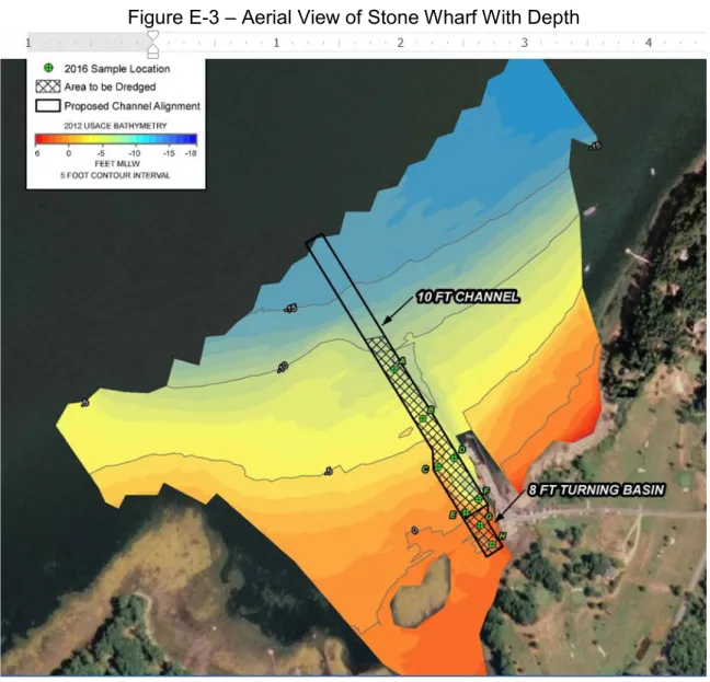
Figure E-3 – Aerial View of Stone Wharf With Depth
A Feasibility Cost Sharing Agreement with the Town of Chebeague Island was signed on July 1, 2016. The principal Federal interests at Stone Wharf are improving the safety and efficiency of commercial navigation for vessels accessing the wharf and landing. The construction method will be mechanical bucket dredge, with off-shore placement of the dredged material. This is an off-shore project with no real estate requirements. All equipment is expected to be brought in by water. No staging or work areas will be needed on shore. The contractor will be responsible for securing their own parking.
3. RECOMMENDED PLAN:
The proposed navigation improvements at Chebeague Landing on Great Chebeague Island would create a new channel at the Stone Wharf. The channel would extend from deep water in Casco Bay southeasterly ~1,600 feet to Great Chebeague Island public landing. The channel would be 100 feet wide and dredged to -10 feet MLLW deep,
widening to 150 feet alongside the pier. An upper turning basin, 0.5 acre in size,
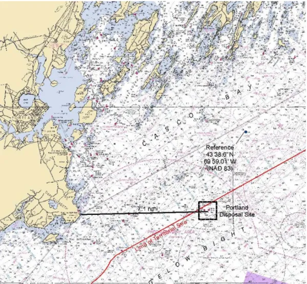
between the channel and the boat/barge ramp would also be constructed by dredging to -8 feet MLLW to accommodate maneuvering of vessels. The proposed action would involve dredging a total of about 33,000 cubic yards of material. The material to be dredged is a mixture of sand, silt, and gravel. Dredging would be by mechanical bucket dredge, with disposal by scow at the Portland Disposal Site (PDS) within about fifteen miles of the island. Bioaccumulation testing was performed of samples of the material to be dredged, and the material was found suitable for disposal at PDS. Officials from the State of Maine and the Town of Chebeague have requested that this project would then be maintained in perpetuity by USACE as a Federal Navigation Project (FNP).
Figure E-4 – Portland Disposal Site
Great Chebeague Island, ME
§107 Navigation Improvement Project
______________________________________________________________________________________ Appendix E - Real Estate November 2020
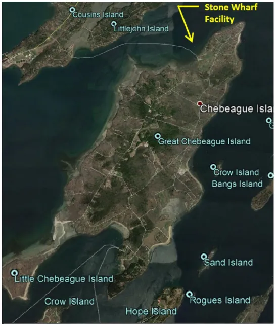
4. REAL ESTATE MAPPING:
A copy of the map showing the approximate location of the area needed for this project. Figure E-5: Location Map of Stone Wharf Facility
5. RECOMMENDED ESTATES
The Project does not require the use of any non-standard estates. No staging or work areas will be needed on shore. The contractor will be responsible for securing their own parking.
6. EXISTING FEDERAL PROJECTS
No Federal projects noted.
7. EXISTING FEDERALLY OWNED LANDS
The project area is within a navigable waterway and contains no lands owned by the Federal government.
8. LANDS OWNED BY THE NON-FEDERAL SPONSOR:
All lands within the proposed project footprint are owned and/or controlled by the non-Federal sponsor.
9. NAVIGATIONAL SERVITUDE
Navigational Servitude applies to this project, due to the project’s nexus to a navigation purpose. It’s anticipated that all construction areas would be subject to Navigation Servitude.
10.INDUCED FLOODING:
There is nothing to indicate that the proposed project features will induce flooding in new areas or increase flooding in existing flood prone areas.
11. BASELINE COST ESTIMATE FOR REAL ESTATE:
Total Project Task Budget
Real Estate Branch Efforts: $5,000
12. PUBLIC LAW91-646 RELOCATIONS:
At this time there will be no displacement of residences or business.
13. MINERAL ACTIVITY:
There is no present or anticipated mining and drilling activity in the vicinity of the project that may affect project purposes and the operation thereof.
Great Chebeague Island, ME
§107 Navigation Improvement Project
______________________________________________________________________________________ Appendix E - Real Estate November 2020
14. TIMBER RIGHTS:
No timber harvesting activities to occur within the proposed project footprint.
15. ASSESSMENT OF NON-FEDERAL SPONSOR ACQUISITION CAPABILITY: The Town of Chebeague Island, ME is fully capable of acquiring real property rights, including utilization of condemnation authority, if project requirements change, during plans and design phase.
16. ZONING:
There are and/or are no zoning ordinances currently proposed in lieu of or to facilitate land acquisition in connection with this project.
17. ACQUISITION SCHEDULE:
A projected schedule has been developed based on the assumption that Federal and non-Federal funds will be available. The tentative schedule for project completion is represented as follows:
Estimated Dates (Milestones)
Initial Meeting Project Start-up Apr-12
Signed Federal Cost Sharing Agreement Jul-16
Real Estate Process REP/LEERD Oct-19
Complete Feasibility Report Sep-20
Initial Design Funding Dec-20
Prepare PMP (Design) Jan-21
PPA Executed Apr-21
Obtain Remaining Design Funding May-21
Start 35% Design May-21
Complete ITR and BCOES Aug-21
RTA Aug-21
Construction Start Nov-21
Midpoint Construction Jan-22
18. UTILITY AND FACILITY RELOCATIONS
There are no utility or facility relocations anticipated or currently required within the proposed project footprint.
19. HAZARDOUS, TOXIC AND REDIOACTIVE WASTE:
No significant adverse environmental impacts are expected from the proposed dredging and disposal. The sponsor fully understands its responsibilities for assessing the
properties for any potential or presence of hazardous waste materials as defined and regulated under CERCLA – Comprehensive Environmental Response, Compensation, and Liability Act – otherwise known as CERCLA or Superfund. There are no known “Superfund” sites or sites presently under CERCLA remediation or response orders identified in the project area. There are no known presences of any substances in the project area that are regulated under CERCLA or other environmental statutes or regulations.
20. ATTITUDES OF THE LANDOWNERS.
There have been no comments reported in regards to support and/or opposition to this project. The proposed project will be offered to the public through the 30-day public notice period to solicit comments and concerns.
21. NOTIFICATION TO NON-FEDERAL SPONSOR:
The non-Federal sponsor executed the Feasibility Cost Sharing Agreement (FCSA) on July 1, 2016.
Great Chebeague Island, ME
§107 Navigation Improvement Project
______________________________________________________________________________________ Appendix E - Real Estate November 2020
From: Daly, Gaelen C CIV USARMY CENAE (USA)
To: Bradstreet, Pamela S CIV USARMY CENAE (US)
Subject: FW: Great Chebeague REP--yes to nav servitude (UNCLASSIFIED)
Date: Wednesday, September 23, 2020 8:59:03 AM
Attachments: Appendix-E-Chebeague-RealEstate-Aug20.pdf
---Original
Message---From: Byars, Julie A CIV USARMY (USA) Sent: Monday, September 21, 2020 10:58 AM
To: Daly, Gaelen C CIV USARMY CENAE (USA) <[email protected]>; McCabe, Maureen A CIV USARMY CENAE (USA) <[email protected]>; Bradstreet, Pamela S CIV USARMY CENAE (US) <[email protected]>
Subject: FW: Great Chebeague REP--yes to nav servitude (UNCLASSIFIED) All,
I reviewed the attached REP for the Section 107 navigation project located in Chebeague, Maine. I agree that the navigation servitude would apply to this project.
Thank you. Julie A. Byars
Assistant District Counsel U.S. Army Corps of Engineers 696 Virginia Road
Concord, MA 01742
ATTORNEY CLIENT PRIVILEGED, DO NOT FORWARD, DO NOT RELEASE ---Original
Message---From: Daly, Gaelen C CIV USARMY CENAE (USA) Sent: Friday, September 18, 2020 9:37 AM
To: Byars, Julie A CIV USARMY (USA) <[email protected]> Subject: FW: Great Chebeague REP--yes to nav servitude (UNCLASSIFIED) Julie,
I have to finish my DQC of this project by the end of this month. Will you be able to review it before then? Thanks,
Gaelen
---Original
Message---From: McCabe, Maureen A CIV USARMY CENAE (USA) Sent: Wednesday, September 16, 2020 1:28 PM
To: Byars, Julie A CIV USARMY (USA) <[email protected]>
Cc: Bradstreet, Pamela S CIV USARMY CENAE (US) <[email protected]>; Daly, Gaelen C CIV USARMY CENAE (USA) <[email protected]>
Julie,
Gaelen told me that you and he had a conversation about Real Estate Plans and invoking navigation servitude. My understanding is that you want to review all plans that affirmatively state that navigation servitude applies to some of the areas needed for the project. Could you clarify and let me know if you want to see all REPs, even if Real Estate thinks the navigation servitude does not apply?
Great Chebeague is a Section 107 Navigation Improvement Project to dredge by a wharf. No staging or work areas will be needed onshore. In Real Estate's opinion, navigation servitude applies because: (1) the project is in the aid of commerce (navigation); and (2) the land to be dredged is below the man high water mark of a navigable watercourse (Casco Bay/Atlantic Ocean). Will you review this REP and the language in Section 9 saying that the navigation servitude applies?
If you commented on this back in October 2019, I apologize for asking you again. Pam is in the field through Friday, and Gaelen is doing District Quality Control review on this now.
Thanks. Molly
CLASSIFICATION: UNCLASSIFIED
Great Chebeague Island, ME
§107 Navigation Improvement Project
______________________________________________________________________________________ Appendix E - Real Estate November 2020