Power, Status and War: The Archaeology
of the Castle in North West England.
Nevell, MD, Nevell, R and Grimsditch, BH
Title
Power, Status and War: The Archaeology of the Castle in North West
England.
Authors
Nevell, MD, Nevell, R and Grimsditch, BH
Type
Book Section
URL
This version is available at: http://usir.salford.ac.uk/26999/
Published Date
2012
USIR is a digital collection of the research output of the University of Salford. Where copyright
permits, full text material held in the repository is made freely available online and can be read,
downloaded and copied for noncommercial private study or research purposes. Please check the
manuscript for any further copyright restrictions.
P
ow
er
, Status and W
ar
: T
he Archaeolo
g
yo
f the Nor
th W
est Castle
[image:2.595.57.593.48.573.2]CHAPTER 1
CHAPTER 1
P
ow
er,
Status and W
ar
: T
he Archaeolo
g
yo
f the Nor
th W
est Castle
Chapter 1
Power, Status and War: The Archaeology of
the Castle in North West England
Introduction
In January 1360 a jury of tenants was summoned from across the Lord-ship of Longdendale; the historic pan-handle of Cheshire. They were tasked to give evidence under oath about landholdings and land values within the upland lordship. The evidence was given in front of officers appointed on behalf of the Black Prince, then earl of Chester and Lord of Longdendale. Amongst the records of that day was a reference to
‘one ruined castle called Buckeden and of no value.’1 This was the first,
indeed the only, reference to the enigmatic earthwork at Buckton dur-ing this period; it does not tell us who built the castle, nor why. Nor does it explain how the castle fell into ruin.
In later years Buckton was marked on a 16th century estate map,
re-corded in 18th century estate letters, and from the mid-19th century was
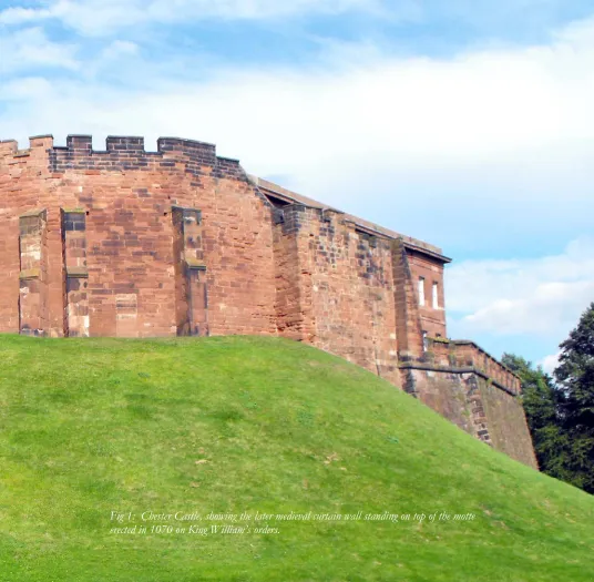
the subject of local antiquarian and archaeological curiosity. Interest in the castle was revived during the 1990s and the recent excavations at this site are the culmination of nearly 20 years of archaeological re-search. The castle is a ruin well known in its immediate locality, al-though until recently it was largely overlooked as a medieval fortifica-tion. This chapter will attempt to place the stone enclosure castle at Buckton within a wider landscape setting that will look at the military, political and social context of the castle in North West England (Fig 1).
The Research and Excavation of Castles in the
North West
The term ‘castle’ covers a wide variety of medieval fortifications and typically refers to a building that is “the fortified residence of a lord”,
according to Allen Brown.2 The first castles in England were built by
ow
er
, Status and W
ar
: T
he Archaeolo
g
yo
f the Nor
th W
est Castle
CHAPTER 1
The first castle
to be built in
North West
England was
not until 1070,
when the motte
at Chester was
erected by King
William
Normans in the service of Edward the Confessor during the 1050s: four in Herefordshire and one in Essex. With the Norman Conquest the number of castles increased dramatically and they became a lasting
feature of the English landscape.3 However, the first castle to be built
in North West England was not until 1070, when an artificial earthen mound known as a motte, with a wooden tower on the top, was erected at Chester by King William (Fig 1).
Although 21st century North West England encompasses two historic
borders (those with north-eastern Wales and south-western Scotland)
the 83 castles definitely known within the region account for less than
ten percent of the total number of castles recorded in England; a per-centage not significantly increased by the identification of a number of
undocumented earthwork sites in recent years.4 This number is based
primarily on Cathcart King’s index, with amendments where necessary (see Chapter 5). The study of castle sites in the region can, perhaps, be traced to Speed’s maps of Cheshire and Lancashire (Fig 2) surveyed in
[image:4.595.112.451.52.315.2]the early-17th century. These included the earliest plans of any of the
CHAPTER 1
P
ow
er,
Status and W
ar
: T
he Archaeolo
g
yo
f the Nor
th W
est Castle
The earliest
Archaeological
excavations on a
North West
cas-tle took place in
the 19
thcentury
castle sites from the region. Antiquarian interest in the 18th century
fo-cused upon the dramatic setting of the ruined castles, with the Buck Brothers sketching many of the stone castles of the region in the
late-1720s and 1730s (Fig 3). In the late-18th and early-19th centuries castle
sites were also the subject of several paintings by landscape artists in-cluding John Constable and Joseph Turner as well as local artists such
as Moses Griffth.5
The earliest archaeological excavations on a North West castle took
place in the 19th century with the investigation of the earthworks at
Penwortham, near Preston, and Mote Hill to the north of Warrington. Results from these were not very revealing and in some cases have been lost entirely; as with the early investigations at Hornby in the Lune
val-ley.6
The 20th century saw an upsurge in interest in the castles of the region
with an increasing number of archaeological and historical studies, and a growing list of protected sites (Fig 4). This work included several landscape studies. Cathcart King’s monumental survey of the castles of
England and Wales, published in 1983,7 included entries for 78 castles
and 86 tower houses in the region with bibliographies for each, al-though no plans nor elevations were included. As befits their more nu-merous nature, the castles and tower houses of Cumbria saw three
ma-jor studies in this century.8 The less numerous castles of the truncated
post-1974 county of Lancashire had three significant studies during this
century.9 The late 20th century metropolitan areas of Liverpool and
[image:5.595.156.481.399.531.2]Manchester have none, and more surprisingly Cheshire also lacks a de-tailed landscape overview of its castles. Although it has been covered in a gazetteer published in 2001, that work mirrors the studies of Cathcart
ow
er
, Status and W
ar
: T
he Archaeolo
g
yo
f the Nor
th W
est Castle
[image:6.595.113.432.52.528.2]CHAPTER 1
CHAPTER 1
P
ow
er,
Status and W
ar
: T
he Archaeolo
g
yo
f the Nor
th W
est Castle
King by overlooking Watch Hill near Altrincham and locating Buckton
Castle in Lancashire rather than in Cheshire.10
Despite the unevenness of the historical studies of North West
cas-tles during the 20th century, excavation and survey work during this
period encompassed 27 sites. This work ranged from fabric surveys and test pitting to area excavations, with a large bias towards the investiga-tion of stone castles. Archaeological work on earthwork and timber castles often focused on those that developed into important later cas-tles. In Cheshire these were the castles at Aldford and Nantwich. In Greater Manchester small-scale investigations were undertaken on early sites at Watch Hill in 1976, Rochdale in 2001 and at Manchester Castle, in the grounds of Chetham College, in the early 1980s, the latter
expos-ing a possible inner defensive ditch.11 West Derby12 was the only
earth-work to see significant investigation in the Merseyside area during this
period. In Lancashire no mottes were investigated during the 20th
cen-tury and little archaeological work has been undertaken on Cumbria’s northern earth and timber castles. The exception was the major
excava-tions by Davison during the 1960s at Aldingham.13
The most extensively investigated stone castle in the region is Bee-ston in Cheshire (Fig 5). This was the subject of excavations between
1968 and 1985,14 which showed the outer curtain wall for the early-13th
century stone castle was built on the remains of a late-Bronze Age and early-Iron Age hillfort. Elsewhere in the region the stone castles at three of the county towns have been studied. The fabric of Carlisle Cas-tle, and its associated town walls, has been extensively recorded though
only parts of the defensive ditch system have been investigated.15 The
stone castles at two other medieval county towns in the region, Chester and Lancaster, have seen only very limited excavation work. Elsewhere
in the region the stone castle at Liverpool16 has seen only small-scale
investigation. Halton on the southern side of the Mersey estuary has seen more investigation though this was confined to a series of
evalua-tion trenches.17 Yet such a limited approach can provide extremely
use-ful results; the location of the late medieval castle at Lathom in
south-west Lancashire, which was rebuilt on a palatial scale during the 15th
century, has recently been confirmed by just such evaluation work.18 In
Cumbria the stone castles at Brougham, Brough, and Piel19 have all
seen small-scale excavation combined with standing building work. In-vestigations at the stone castle at Kendal have helped to confirm the
Archaeological
work on
earth-work and
tim-ber castles often
focused on
those that
ow
er
, Status and W
ar
: T
he Archaeolo
g
yo
f the Nor
th W
est Castle
CHAPTER 1
rather sporadic historical record, although its origins as an earth and timber castle remain uncertain. Other stone castles in Cumbria to
re-ceive archaeological attention in the late 20th century include
Pen-dragon, where recording has been undertaken of the upstanding eleva-tions as well as partial clearance of collapsed masonry. Limited
re-cording and excavation work has also taken place at Egremont.20
[image:8.595.115.437.58.432.2]The recent work at Buckton Castle, in Greater Manchester, thus represents the most extensive programme of castle excavation in the
CHAPTER 1
P
ow
er,
Status and W
ar
: T
he Archaeolo
g
yo
f the Nor
th W
est Castle
North West, in terms of the percentage of the defences and interior investigated, since the work at Beeston. It also fits into a pattern of re-search on the stone castles of the region that first began in the 1970s.
The Earliest Castles in North Western England
The first castles in the region were built of earth and timber as motte
and bailey types, and have traditionally be assigned to the late-11th and
12th centuries.21 Many of these early castles acted as both baronial
strongholds and estate administrative centres, as well as strategic
mili-tary installations,22 although some may have been short-lived.
In Cheshire most of the 13 definite mottes lie in the western third of the county, along the border with Wales, with earth and timber castles known at Aldford, Castleton (Church Shocklach), Chester, Dodleston, Malpas (Fig 6), Pulford and Shotwick. These motte and bailey castles have been considered to belong to the immediate post-Norman Con-quest period, though most have not been extensively investigated and
where they have, as at Aldford23 the excavations produced no evidence
for occupation before the 13th century. Elsewhere within the county
other earthwork castles include Castle Cob, Frodsham, Nantwich, and Northwich which all appear to have been associated with baronial hold-ings. Chester and Shotwick were both held by the earls of Chester and
were rebuilt in stone in the late-12th and 13th centuries.
The Greater Manchester area, which comprises the historic northern fringe of Cheshire and the south-eastern part of ancient Lancashire, has seven earthwork castles, nearly all of which can be associated with ba-ronial holdings. These include the three castles on the northern side of
the River Bollin at Dunham, Watch Hill and Ullerwood24 which were
all held by the de Massey family. Despite excavation dating evidence for
the motte at Blackrod is lacking. Manchester, first referred to in 118425,
and Rochdale were the centres of large estates in the 12th century. It is
unclear what type of castle was at Stockport when it was mentioned in 1173 but it was probably a motte with a timber tower. Buckton Castle, was not mentioned in the documents until 1360, by which date it was in
ruins.26
There are two concentrations of earth and timber castles within mod-ern Lancashire. Firstly, there was a scattered line of mottes along the Ribble valley. Secondly, there is a larger group of earthwork and timber
Many of these
early castles
acted as both
baronial
strong-holds and estate
ow
er
, Status and W
ar
: T
he Archaeolo
g
yo
f the Nor
th W
est Castle
CHAPTER 1
castles in the Lune valley.27 These sites include the well preserved and
largely unexplored castles at Halton and Hornby, and the early-12th
cen-tury castle that preceded the later masonry structure at Lancaster. Cumbria’s mottes are probably later than those further south in the region, since much of this area was not conquered by the Normans
until the end of the 11th century, and was in the hands of the Scots
dur-ing the mid-12th century. It was subject to invasion and raiding
throughout the late-12th, 13th and early-14th centuries. The fluctuating
[image:10.595.114.429.52.402.2]border with Scotland during this period probably helped to dictate the distribution of the earth and timber castles in this part of the North
Fig 6: The western edge of the motte at Malpas, look-ing north-eastwards across the modern town towards Beeston Castle.
CHAPTER 1
P
ow
er,
Status and W
ar
: T
he Archaeolo
g
yo
f the Nor
th W
est Castle
West and in some cases these castles are grouped in pairs in the land-scape, either side of the late medieval border, as at Liddel Castle and
Liddel Strength.28 Thus, most of Cumbria’s mottes lie close to the
Scot-tish border, though as Newman has pointed out whether they truly rep-resent national defensive lines, or reflect the militaristic and feudal
na-ture and status of the 12th and 13th century landholdings is arguable.29
The Stone Castles
Amongst the 83 castles (Figs 4 & 12) known from the region 44, with the addition of Buckton to Cathcart King’s list, were either mottes re-built in stone or were stone castles from the very beginning. The lack of extensive excavations on most of these sites means it is difficult to be sure which were the earliest masonry castles, or how many had a timber
predecessor. However, documentary material (Fig 7) indicates the 12th
and 13th centuries saw extensive rebuilding activity across the region.30
The earliest masonry fabric in any North West castle may be the her-ringbone walling work visible at both Brough and Egremont in Cum-bria. The fabric at Brough dates to around 1100, whilst that at
Egre-mont is probably from the 1120s.31 Elsewhere in Cumbria there are a
line of stone castles, including Brougham, Brough, Penrith, and
Pen-Fig 7: The date of the first record of castles in the North West. Three broad phases of activity can be seen; the late-11th to early-12th centuries; the late-12th to late-14th cen-turies, and the later 15th century. The peak in the
1320s reflects the response to the harrying of northern England by Robert the Bruce of Scotland.
[image:11.595.98.478.336.534.2]ow
er
, Status and W
ar
: T
he Archaeolo
g
yo
f the Nor
th W
est Castle
CHAPTER 1
dragon, guarding the upper Eden Valley and the strategic Stainmore pass into north Yorkshire. Norman keeps, probably from the mid- to
late-12th century, can be found at Appleby (built around 1130), Brough
(Fig 8, Brougham (built around 1200), and Carlisle (Fig 9).32 The keeps
at Appleby, Brough, and Brougham were all raised by a single storey
soon after their completion whilst in the 13th century round towers
were added to Appleby and Brough.
The two earliest masonry castles in Lancashire are both built on rocky outcrops above river crossings. The first three storeys of the keep at
Lancaster are thought to date from c. 1130,33 judging from the survival
of round-arched windows with attached shafts and the presence of pi-laster buttresses at each corner. Entered from the first floor it had a classic central dividing wall. The upper storey of the keep was added in
the 13th century, as at Appleby, Brough, and Brougham. The curtain
walls at Lancaster were later and included the surviving Well Tower of
c. 1265 with its garderobes. The monumental gatehouse with its two
octagonal towers was later still, probably being in the early 15th
cen-tury. Clitheroe Castle (Fig 10) is documented in the first half of the 12th
century, but the small stone keep (11m2) is late-12th century in style.
[image:12.595.113.435.57.281.2]Like Lancaster it was entered at first floor level, it also had external
Fig 8: The ruined keep at Brough, which is 12th century, although other parts of the castle may date to c. 1100.
The lack of
extensive
excava-tions on most of
these sites means
it is difficult to be
sure which were
the earliest
ma-sonry castles, or
how many had a
timber
CHAPTER 1
P
ow
er,
Status and W
ar
: T
he Archaeolo
g
yo
f the Nor
th W
est Castle
chamfering at the base of the corners.34
Liverpool Castle, an enclosure castle demolished in 1726, was built in stone around 1235 by William de Ferrers to guard the medieval town. It had a moat and a curtain wall with five D-shaped towers, two of which formed a gatehouse. The main building in the interior was a large stone
hall.35 It has similarities to some of the castles built or rebuilt by Ranulf,
sixth earl of Chester, in the earlier 13th century at Beeston (see below),
Chester, and Chartley, including the towered gateway and the D-shaped wall towers.
In Cheshire the earliest stone fabric is to be found in the lower two storeys of the Agricola Tower, the original gatehouse to the inner bailey of Chester Castle. This square three-storey tower was begun in the
late-12th century by Ranulf, sixth earl of Chester, although the rib-vaulted
gateway tunnel was built after a fire in 1302.36 New inner and outer
gateways were added in the early-13th century by Ranulf and each had a
pair of D-shaped towers similar to the ones built at Beeston, though the Chester examples were demolished during rebuilding work in the
[image:13.595.169.483.298.537.2]1800s.37 Some medieval fabric also survives in the Flag Tower and Half
Fig 9: The keep at Carlisle Castle dates to the 12th century.
The two earliest
masonry castles
in Lancashire
are both built
on rocky
ow
er
, Status and W
ar
: T
he Archaeolo
g
yo
f the Nor
th W
est Castle
CHAPTER 1
Moon Tower, also in the inner bailey.
Elsewhere in the county Halton Castle, possibly established as a motte and bailey in the 1070s by Nigel, the baron of Halton, on the
southern bank of the River Mersey, was rebuilt in stone in the 13th
cen-tury.38 The inner bailey is formed by the remains of a stone wall, which
[image:14.595.111.541.52.449.2]is thought to be mid-13th century, with a western square tower and a
CHAPTER 1
P
ow
er,
Status and W
ar
: T
he Archaeolo
g
yo
f the Nor
th W
est Castle
circular tower on the northern side of the bailey. A range of buildings
interpreted as a kitchen block are also thought to be 13th century in
ori-gin, whilst the outer gateway was rebuilt in the 15th century The inner
bailey is often described as a shell keep39 though the irregular shape of
the enclosure does not fit the normal description of such sites.
[image:15.595.171.483.307.528.2]The best known, certainly the most prominent, of all the castles in Cheshire is Beeston (fig 11). This castle sits atop an outcrop of sand-stone dominating the Cheshire plain. It was characterised by an inner and outer bailey with stone defences to the south where the slope did not provide a natural obstacle. Begun in the 1220s by Ranulf, sixth earl of Chester, the design uses its elevated central position to create a dra-matically imposing site. The outer and inner gateways each have pairs of D-shaped towers, which are some of the earliest examples in Eng-land, and were possibly inspired by Ranulf’s knowledge of castles in the eastern Mediterranean from his time on crusade. Seven surviving D-shaped towers line the outer bailey wall. The inner gateway, with its pair of D-shaped banded towers, had a single room above the entrance, a portcullis groove and a pit for a drawbridge. Aside from the gatehouse there are three D-shaped towers distributed between the southern and
Fig 11: The inner bailey at Beeston Castle viewed from the east.
In Cheshire the
earliest stone
fabric is to be
found in the
lower two storeys
of the Agricola
Tower, the
original
gate-house to the inner
ow
er
, Status and W
ar
: T
he Archaeolo
g
yo
f the Nor
th W
est Castle
CHAPTER 1
eastern walls of the inner bailey. Discounting what are likely to be tem-porary structures associated with the building work, no features were
discovered within the inner bailey.40
There are no above-ground remains for the other stone castles built
in Cheshire during the 12th and 13th centuries: Buckton and Shotwick.
The form and fabric of Buckton is discussed in detail in Chapter 3. It is uncertain when Shotwick was founded, and although it may have been
founded as a motte in the 12th century, by 1240 there was a polygonal
stone keep here. It fell into decline in the 14th century when much of
the stone fabric appears to have been removed.41
Castles in the Landscape: Power & Status
The wider landscape context of the castles of North West England can be seen in several ways. Many sites, especially the earlier mottes, were undoubtedly positioned strategically as part of the initial Norman
con-quest of the region, and were garrisoned accordingly.42 The guarding of
routeways and river crossings is especially notable in the distribution of mottes in the region. Alford and Pulford lie on the banks of the River Dee, south of Chester, guarding river crossings. Watch Hill in Bowdon guards the Roman river crossing of the Bollin in northern Cheshire, whilst the nearby Ullerwood Castle also guards a crossing of the River Bollin. The motte at Penwortham lies beside a crossing of the Ribble opposite Preston where there was a second motte. Another pair of mottes at Arkholme and Melling (Fig 4) on the river Lune in northern Lancashire guarded a further river crossing, and the motte at Halton further downstream performed a similar function. The motte at Old Tebay, the northern-most of a line of earthworks in the Lune valley, sits by the river and seems to have guarded the routeway up the valley
to-wards the pass at Shap.43 A line of castles guard the Stainmore pass and
the upper Eden Valley (Fig 12) – Appleby, Brough and Brougham. Fi-nally, Liddel Castle sits on the southern bank of the Liddel Water on the late medieval Scottish border. A Scottish castle, Liddel Strength, lay on the opposite bank and both guarded a fording point on the river. The concentration of castles along the present political frontiers be-tween England and Scotland, and England and Wales in the North West hides a much more complicated political and social position in the Anglo-Norman period. The border of Cheshire and England in the late
The best
CHAPTER 1
P
ow
er,
Status and W
ar
: T
he Archaeolo
g
yo
f the Nor
th W
est Castle
[image:17.595.170.483.129.533.2]Saxon period extended westwards into modern Wales to encompass the coastal territory of Flintshire (Atticross Hundred in the Domesday Book) and the Vale of Clwyd – modern Denbighshire. For much of the two centuries before the final conquest of northern Wales by Edward I in the 1280s, the English-Welsh border lay along the Vale of Clwyd and
ow
er
, Status and W
ar
: T
he Archaeolo
g
yo
f the Nor
th W
est Castle
CHAPTER 1
modern north-eastern Wales was part of what might be called Welsh Cheshire. There were exceptions to this Norman dominance. The bor-der was pushed eastwards to the Dee Valley by several Welsh princes; under Owain Gwynedd in the 1140s, by Llewellyn ab Iorwerth in the 1200s, and in the 1260s and 1270s under Llewellyn ap Gruffuth. Rich-ard Newman has suggested the first of these periods of Welsh suprem-acy might be the context for the building of a series of mottes along the lower Dee valley. Furthermore, he has gone on to suggest this was not a formal frontier but might be interpreted as a series of responses by
local Norman lordships to Welsh raids.44 The sites around Aldford and
Pulford appear to be blocking a Welsh raiding route south of the marshes around Saltney for instance, whilst the mottes to the west of Malpas would appear to guard a river crossing of the Dee. None of the mottes along the Dee valley appear to have been rebuilt in stone, probably because the stabilisation of the Welsh frontier by the conquest
of Gwynedd at the end of the 13th century removed the strategic need.
The development and defence of the border between England and Scotland was more drawn-out and more complicated than that of the northern Welsh border adjoining Cheshire. Its current position along
Liddel Water (Fig 13) was only reached in the 14th century and even
then border warfare continued at a low level into the mid-16th century.
[image:18.595.112.538.340.529.2]In the 11th century Cumbria had been part of the British Kingdom of
CHAPTER 1
P
ow
er,
Status and W
ar
: T
he Archaeolo
g
yo
f the Nor
th W
est Castle
Strathclyde; with Carlisle and the Solway plain only falling to William II in 1092. The early mottes along the Kent and Lune valleys may thus
reflect the northern limit of Norman lordship in the late-11th centuries.
Carlisle Castle was founded around 1092 immediately upon the con-quest of the area, whilst the mottes at Kendal (Castle Howe) and at
Cockermouth on the western coast date from the early-12th century and
perhaps represented the consolidation of landholdings by the
Normans.45 Cumbria remained under Norman control until King
Stephen’s reign. In 1136 David I invaded northern England in support of his niece Matilda’s claim to the English throne, occupying Cumber-land, NorthumberCumber-land, and Westmorland. Scottish possession of the northern counties was confirmed by the Treaty of Durham in 1138 and re-enforced by a second Treaty of Durham in 1139, which saw the lordships of Skipton in north-west Yorkshire and Lancaster pass to
Scottish barons.46 This brought the effective boundary of the Scottish
state as far south as the Ribble Valley, where it remained until 1157 when Henry II retook the north through another treaty with the
guardi-ans of the new infant Scottish king.47 It is thus possible that the early
mottes of the Ribble Valley (Penwortham, Clitheroe, Ellenthorpe, and Gisburn) might reflect the response of the local Norman lords to the extension of Scottish frontier into northern Lancashire during the
pe-riod 1136 to 1157.48
Yet castles were more than just defensive positions. They acted as baronial and administrative centres, and as social statements of the power and status of their owners. The recognition of their wider role
grew with a new wave of studies in the 1990s and 2000s.49 These
stud-ies began to apply landscape and social approaches to castle studstud-ies, influenced by archaeological and historical geography methodologies. The location of early mottes within the ruins of old Roman forts might be indicative of a more symbolic statement of power than just the re-using of an old strategic site with ready building materials to hand; William I’s very first castle was built inside the old Roman fort at
Pevensey on the Sussex coast.50 Lancaster Castle, though sited within
the defences of the late Roman fortress overlooking the lowest crossing of the river Lune, was also located on a rocky outcrop that dominated the lower part of the valley and the estuary to the west. It was thus a
highly visible symbol of late-11th century Norman power in a frontier
region. In Cumbria the castles at Appleby, Brough, Brougham (Fig 14),
Mottes along
the Kent and
Lune valleys
may thus reflect
the northern
limit of
Norman
lordship in the
late-11
thow
er
, Status and W
ar
: T
he Archaeolo
g
yo
f the Nor
th W
est Castle
CHAPTER 1
and Pendragon lie along the strategic routeway into northern Yorkshire from Cumbria through the Stainmore pass, but two of these castles also sit within the earthworks of Roman forts. The motte at Old Tebay sits immediately north of the Roman fort at Low Borrowbridge in the up-per Lune Valley. Along the border with Scotland the motte at Beau-mont sits on the site of milecastle 70a on Hadrian’s Wall, whilst Bew-castle sat within the north-eastern corner of the Roman frontier fort. The building of castles at the old Roman cities of Carlisle and Chester,
both of which remained significant urban centres in the 11th century,
and both of which lay on river crossings, was probably also a statement of control over the local urban population; a technique frequently used by William I in other English towns (such as Exeter, Lincoln, London,
[image:20.595.113.540.54.361.2]and Norwich) to overawe the Saxon population.51
CHAPTER 1
P
ow
er,
Status and W
ar
: T
he Archaeolo
g
yo
f the Nor
th W
est Castle
A further statement of social power was the linking of castles with the church. Carlisle, Chester, and Lancaster each contained private chapels, as did other lesser castles at Appleby, Askham Hall, Bewley, Brougham, Rose Castle in Cumbria, and Dunham in Cheshire. A sig-nificant number of castles had churches within the bailey or close by. Chapels within the bailey that later went on to become medieval parish churches can be found at Aldford, Dodleston, and Malpas in Cheshire (Fig 15), at Penwortham in Lancashire, and in Cumbria at Beaumont. Medieval parish churches found immediately outside castles in Cheshire can be seen at Chester, Dodleston, Nantwich, and Stockport. In Lanca-shire parish churches adjacent to castles included Arkholme, Bury, Lan-caster, Manchester, Melling, West Derby, and Whittington. In Cumbria these sites could be found at Bewcastle, Castle Carrock, Irthington, and Kirkoswald, although the fewer examples in this part of region proba-bly represents the lower level of population. Where documentary
evi-dence survives, as at Aldford, Chester, Manchester, and Malpas,52 it is
clear these churches were sponsored by the owners of the castles, an extension of their patronage.
In terms of display and status the building of Beeston Castle in cen-tral Cheshire is one of the most imposing examples. Along with Boling-broke, Allan Brown argues that Beeston is one of the first castles in England to dispense with a central tower, thus beginning a period of scientific fortification. Though principles such as using projecting tow-ers to provide flanking fire had been used at Dover Castle, built by
Henry II in the mid-12th century, and Chateau Gaillard, built by Richard
I in the latter half of the 12th century (both royal castles and arguably
the crowning architectural achievement of their respective kings), it was
not until the 13th century that these principles became widespread in
England.53 Beeston Castle was begun by Earl Ranulf III around 1220
using innovative designs which appear to have been inspired by the earl’s time of crusade in the 1210s. These features included D-shaped towers for the outer gateway and curtain wall, one of the first instances of this type of design in England, and an elaborated inner gatehouse with two D-shaped tower picked out with coloured horizontal banding
reminiscent of the design of the walls of Constantinople.54 His lands
ran from Chester in the west to Lincoln in the east and Leicestershire in the east Midlands. His power base, however, was the earldom of Cheshire and Beeston Castle faced east and south-eastwards
overlook-The location of
ow
er
, Status and W
ar
: T
he Archaeolo
g
yo
f the Nor
th W
est Castle
CHAPTER 1
ing the main routes from the Midlands. Beeston was a statement of power and status, and perhaps given its design innovations and echo of Constantinople a statement of military ability, reflecting Ranulf’s
posi-tion as the wealthiest landowner in early-13th century England.
Another remarkable statement of power and status can be seen at Lancaster Castle (Fig 16). Its elaborate south-eastern gatehouse was rebuilt after the Scottish raids of 1389. The work was undertaken by Henry, Duke of Lancaster, in the early 15th century but it reflected more than just the need to repair the neglected castle defences. It has two large octagonal towers topped by machicolations and over the gate-way itself are two coats of arms flanking a slot for a statue. This appears to have been a visible symbol of Henry’s status as earl of Lancaster. He had inherited his estates when his father, John of Gaunt, died in 1399 but these were confiscated by the king upon his death. His son Henry went on to depose Richard and install himself as King Henry IV, thus
bringing the earldom of Lancaster into royal hands.55
[image:22.595.113.424.300.529.2]These castles reflected in stone the desire for comfort, wider social interests, and political concerns of two of the biggest landholders of their period. The increasing importance of display and status also
Fig 15: The mediaeval parish church at Malpas lies within the outer bailey of the castle.
CHAPTER 1
P
ow
er,
Status and W
ar
: T
he Archaeolo
g
yo
f the Nor
th W
est Castle
marked the beginning of a shift away from the military aspect of castle
design, a trend which developed rapidly in the 14th and 15th century.
The Decline of the Castle
The castles built by Edward I in Wales during the late-13th and
early-14th century (such as Caernarfon and Beaumaris), are generally held to
be the pinnacle of medieval military architecture, and in military terms
what follows is an “anti-climax”.56 However, the 14th century saw much
castle construction and it was not until the 15th century that
construc-tion dramatically dropped off.57 From the second half of the 14th
cen-tury, gunloops for the use of gunpowder weapons were incorporated in castle walls, but it wasn’t until the development of large, reliable,
[image:23.595.58.483.56.364.2]ow
er
, Status and W
ar
: T
he Archaeolo
g
yo
f the Nor
th W
est Castle
CHAPTER 1
powder weapons in the 15th century that they became a threat to castle
walls.58 An examination of the licences to crenellate in terms of period
in which they were granted offers insights into the changing nature of castle building. The licences were royal grants of permission to build a castle or fortified house and more likely served more as a status symbol – the holder had the right to one of recognised symbols of nobility – rather than planning permission in a modern sense. There were 252 licences were granted between 1300 and 1399, compared to 66 between
1400 and 1499 and 14 between 1500 and 1569.59 This decline may mark
a decrease in the value placed on a licence and the privilege it granted. The rise of effective gunpowder artillery, controlled by the crown
rather than the unruly feudal lords, culminated in the early-16th century
with a move towards dedicated forts and fortifications.60 As the military
importance of the castle declined the other functions of these sites, as baronial centres and domestic residences, grew in importance. In the North West this was reflected in the alteration and expansion of do-mestic ranges, an increase in administrative buildings such as court houses, and the abandonment of some stone castles. These centuries also saw the growth of the fortified manor house.
The rise in importance of the domestic side of castles was
foreshad-owed by the building of Stokesay Castle (Fig 17) in the 1290s.61 This
had a large four-bay open hall abutting the curtain wall, with a three-storey stone and timber solar wing to the north and a hexagonal four-storey stone tower to the south. The complex was set within a moat but the curtain wall was pierced by windows where the hall range abutted it and the upper floor of the solar range was timber-framed, suggesting the domestic features were of equal importance to the fortified nature
of the site.62
The improvement of the domestic facilities of stone castles and the
rise in importance of display features during the 14th century can be
seen at a number of key sites in England. Dunstanburgh Castle (Fig 18), on a headland on the Northumberland coast with its own harbour, is an example of a castle built for both military strength and display. It was
built by Earl Thomas of Lancaster between 1313 and c. 1322 on the site
of a prehistoric fort and had its own harbour to the east and a northern gateway (Lilburn Tower). To the west were built a string of three shal-low fresh-water meres. The great gateway to the south had twin three-storey round towers. From the top of these tall turrets projected at
CHAPTER 1
P
ow
er,
Status and W
ar
: T
he Archaeolo
g
yo
f the Nor
th W
est Castle
both the southern front and northern rear of the gatehouse. The third floor appears to have contained the main domestic rooms in the castle including a hall and great chamber, which were also accessible from the
inner courtyard of the castle.63 John of Gaunt, fourth son of Edward
III, inherited the castle in 1362 and between 1372 and 1383 modernised the structure. He built a curtain wall behind the great gateway to create an inner bailey, added six domestic buildings, including a new bake-house, and then a new tower and gateway to tightly control access from the outer bailey into the inner bailey. Finally, he built a new gatehouse
and barbican c. 30m to the west of the original great gateway which was
converted into a keep. The castle sat in a wider designed landscape that was used by both Earl Thomas and John of Gaunt. The meres would have given the impression that the castle sat on its own island, with an outer series of defences formed by large earthen banks guiding the
[image:25.595.60.483.57.344.2]ow
er
, Status and W
ar
: T
he Archaeolo
g
yo
f the Nor
th W
est Castle
CHAPTER 1
tor across a broad open area to the great gateway with its lofty turrets, reminiscent of Edward I’s castles at Caernarfon and Conwy. The castle would thus have dominated the surrounding coast and landscape,
act-ing as a statement of the status and power of its lords.64
[image:26.595.111.540.59.371.2]The primacy of display and comfort over military needs is demon-strated by Bodiam Castle in East Sussex (Fig 19). This was built by Ed-ward Dallyngrigge after 1385 under a licence to crenellate that allowed him to fortify his manor house against French raids. Instead he built a new castle on a new site that was roughly square in plan. The interior was completely occupied by the great hall and its domestic ranges set around the inner walls. These buildings included the lord’s hall, a great chamber, chapel, private apartments, kitchen, buttery, pantry, retainer’s
CHAPTER 1
P
ow
er,
Status and W
ar
: T
he Archaeolo
g
yo
f the Nor
th W
est Castle
hall, and stables. There were three-storey circular towers at each corner of the curtain walls and projecting square central towers in the south-ern, eastsouth-ern, and western walls. The main entrance was through the northern gateway that had twin octagonal towers three-storeys high, with gun loopholes, leading to a drawbridge across the moat. Several elements of the castle suggest comfort and display were more impor-tant than defence, although its very presence must have acted as a
de-terrent to the French Channel raiders of this period.65 Firstly, large
win-dows in the curtain walls provided lighting for these domestic struc-tures. Secondly, the moat was terraced into the hillside on its northern side and damned on its southern side which would have made it very easy to drain in any siege. Thirdly, there were a series of millponds im-mediately to the south, re-enforcing the impression of the castle sitting on its island within an extensive watery landscape. Finally, the presence of gunloops in the castle may not have been practical, and may have been intended to demonstrate the owner’s knowledge of military
vo-cabulary, as it were.66
The shift from defence to domestic and display concerns can also be seen at existing castle sites. Warkworth Castle (Fig 20), on the river Aln
in Northumberland, was a 12th century motte and bailey with a tower
keep, which saw use and development down to the end of the 16th
cen-tury. It was owned by the Percy family, dukes of Northumberland, the most important noble family in the north, and who were regularly in-volved in court politics. Here, the keep, sited on the earlier motte, was
rebuilt in the late-14th century by Henry Percy, first earl of
Northum-berland. Its new design illustrates the increasing importance of display
and comfort.67 It was laid out in the form of a Greek cross with four
floors. The first storey was used for storage while the second contained the kitchens. The third storey contained the two-storey great hall, a chapel, and a receiving room, with the kitchen range occupying the western side of the floor. The fourth storey housed the bedrooms and withdrawing rooms. Externally, the bailey elevation was dominated by large traceried windows, especially on the third and fourth storeys, and was topped with battlements and beneath these were carvings of angels carrying shields. The north face overlooked the town and was deco-rated with the Percy lion. A square tower at the northern end of the keep rose two storeys above the main structure, emphasising further the height of the keep by its position on the original motte that stood
Dunstanburgh
ow
er
, Status and W
ar
: T
he Archaeolo
g
yo
f the Nor
th W
est Castle
CHAPTER 1
on the edge of the River Aln, which flows in a deep gorge beside this part of the castle. The great hall on the western side of the bailey was rebuilt in the 1480s and the new building included a northern public entrance from the courtyard through the two-storey Lion Tower, with the Percy coat of arms on it.
Amongst the castles of the North West several show signs of conver-sion to more domestic uses. This usually took the form of the rebuild-ing and addition of new private apartments and status features such as gateways and battlements, and can be seen at the castles owned by the Clifford family in Yorkshire (Skipton) and Cumbria (Brough and Brougham) during the late medieval period. Brough Castle (Fig 21), in the upper Eden Valley, saw two significant phases of late medieval de-velopment. In the 1380s Roger, fifth Lord of Clifford, rebuilt both the southern curtain wall and the two-storey hall range with new large trac-ery windows in the southern curtain wall. Around 1450 Thomas Clif-ford built an inner service range on the eastern side of the hall and
rein-forced the gatehouse with buttresses.68 Brougham, 18 miles to the
north-west, was a 13th century castle that saw a number of late medieval
rebuildings and additions. The three-storey gatehouse, with its inner
and outer gatehouses and a courtyard in between, was early-14th
cen-tury. The early 13th century keep was raised by a fourth storey at the
same time. The great hall south-east of the keep was rebuilt in the
late-14th century with large traceried windows. At Cockermouth on the
Cumbria coast Thomas de Lucy built a new hall range with solar and kitchen on the north-western side of the inner bailey around 1360. This too involved punching large window openings into the earlier curtain
wall.69
Piel Castle, on an island off the southern coast of the Furness penin-sula, was built in the late medieval period and incorporates the domes-tic and display features seen elsewhere in the north. A licence to crenel-late the site was granted in 1327 to John Cockerham, abbot of Furness. The castle was probably used to protect the abbey from sea-borne raids
into Barrow harbour70 and much of the fabric is thought to date from
the 14th and 15th centuries. The site is dominated by a keep on a cliff
edge, which is enclosed to the south and east by an inner and outer bai-ley, each with their own ditch. The massive three-storey keep has an-gled corner buttresses and, unusually, two spine walls instead of one, dividing it into three parallel sections. Private apartments occupied the
CHAPTER 1
P
ow
er,
Status and W
ar
: T
he Archaeolo
g
yo
f the Nor
th W
est Castle
upper two floors; these were lit by large windows that give the keep a domestic appearance.
[image:29.595.58.482.54.373.2]The last purpose-built castle in the region shows both these castle design developments (more prominent domestic buildings and display elements). Penrith Castle was built by Ralph Neville on a hill overlook-ing the town, after he had been granted the manor of Penrith in 1396. He appears to have built the moat and drawbridge, crenellated curtain wall, two-storey gatehouse, and a range of apartments, including a great hall, along the north-eastern and south-eastern sides of the enclosure. His son Richard Neville built the three-storey red tower in the north-western corner of the compound around 1430. The castle was granted to Richard, duke of Gloucester, later King Richard III (1483-85), in
Fig 19: Bodiam Castle, built in the 1380s, looks impregnable but the moat was terraced into the hillside and the castle
ow
er
, Status and W
ar
: T
he Archaeolo
g
yo
f the Nor
th W
est Castle
CHAPTER 1
1470. He undertook significant alterations to the castle, which were focussed upon domestic accommodation and display. New heated do-mestic buildings were constructed along the north-western and south-western sides of the courtyard. To light the new private apartments large windows were inserted in the curtain wall. Finally, a new outer gatehouse to enhance the north-western approach to the site, was built
over the moat.71
The trend towards display and status can also be seen in the fortified
manor houses of the region, which began to emerge during the 14th
[image:30.595.114.541.56.401.2]century. Their construction reflected not only the continued insecurity
Fig 20: Warkworth in Northumberland had a keep that was a late
CHAPTER 1
P
ow
er,
Status and W
ar
: T
he Archaeolo
g
yo
f the Nor
th W
est Castle
of the northern frontier with Scotland but also the wealth and competi-tion within and between the late medieval landed elite. These fortified manor houses were characterised by a three- or four-storey square-plan stone tower at one end of an open medieval hall. Many of these late medieval sites had licences to crenellate from the king. In Cheshire two
licences were given in the 14th century, for Doddington Hall in 1364
and Macclesfield Castle in 1398. Within historic Lancashire five licences
are known, all from the 15th century; Thurland Castle in 1402, Radcliffe
Tower in 1403, Stanley Tower in 1406, Bury Castle in 1469, and
Green-halgh Castle in 1490.72 Cumbria had 18 sites with licences to crenellate,
which is than double the number to be found in Cheshire and
Lanca-shire combined73 emphasising its closer position to the unstable
Scot-tish border. Of these licences 13 dated to the period 1307-36, a period of intense warfare between England and Scotland. During the reign of Robert the Bruce between 1306 and 1329 the Scots raided deep into northern England, burning manors and villages as far south as northern
Yorkshire and central Lancashire.74 The remaining five Cumbrian
li-cences to crenellate came from later in the 14th century.
Bury Castle, with a licence to crenellate in 1469, was another 15th
cen-tury site with a large central tower on a substantial rectangular, but-tressed platform surrounded by a moat. However, many other de-fended sites did not have a licence. Along the Lune Valley to the north-east of Lancaster the line of early motte and bailey castles were replaced
in the 14th and 15th centuries by a series of fortified manor houses with
stone towers, at Ashton, Borwick, Hornby, and Thurland.75 Whilst
fur-ther north dozens of pele towers, defended stone refuges for farming
families, were built in the 15th and 16th centuries in response to the
ac-tivities of the border reevers – livestock raiders. The largest and most elaborate of the late medieval fortified manors of the region was Lathom House in western Lancashire. This was built by Thomas Lord Stanley in the period 1459-1504. It had a central keep, two courts,
eleven towers, and a double moat,76 but was demolished after the First
Civil War in 1646, so its grandeur can only be recovered by archaeo-logical work. The scale of the central keep may have been influenced by
the design of Penrith Castle.77
Several other trends in the development of the stone castles of the region can also be seen. Some fell into decline and ruin. In Cheshire Buckton Castle was a ruin by 1360 and Shotwick fell into decline at the
The trend
ow
er
, Status and W
ar
: T
he Archaeolo
g
yo
f the Nor
th W
est Castle
CHAPTER 1
end of the 14th century. Stockport Castle had been partly built over by
the expanding market town by the 16th century.78 Beeston Castle,
how-ever, appears to have been maintained by the Crown.79
Yet the defences of a number of northern castles were improved in
the 14th century. At Clitheroe a new outer bailey gateway was built in
1324; at Brougham the curtain wall was repaired and a round tower added in 1319; and the outer gatehouse at Carlisle was rebuilt in 1378. This rebuilding work probably reflected the continuing threat of war and the chronic instability of the border with Scotland.
A shift towards administrative functions can be seen at other castle sites. Halton was used as a courthouse and prison from 1423 onwards and a new outer gatehouse with polygonal towers, like those at Lancas-ter, was built in the 1450s, the present courthouse was built in 1723. The courthouse at Clitheroe Castle was added even later, being erected
in the early 19th century. Two other castles in the region retained an
administrative function into the post-medieval period; Chester and Lan-caster. Chester Castle had a major administrative and symbolic function from its initial construction in 1070-1. Improvements under the Crown
during the later 13th and 14th centuries included the building of
substan-tial accommodation for both the constables and the Royal family and a
new court house.80 Lancaster Castle developed a role as a prison and
court from the early-19th century. Like Chester, this led to the
demoli-tion and rebuilding of a significant part of the castle and has hampered the later archaeological study of the complex. Nevertheless, there is
extensive evidence for the castle’s refurbishment during the late-14th
and early-15th century which included the rebuilding of the elaborate
outer bailey gateway.81
Henry VIII’s coastal fortifications of the 1530s and 1540s marked the end of traditional castle building in Britain and the emergence of
forts.82 Sites such as Camber Castle in East Sussex and Deal Castle in
Kent were gun-emplacements with an interleaving circular-tower plan and moats with raked sides designed to absorb cannon fire. These forts, with their squat towers, were visually quite different from the classic medieval castle. Even though they contained accommodation blocks in
the central tower83 they were quite clearly different to the medieval
cas-tle in their function and design.84 They were no longer defended
resi-dences but fortifications under royal control. In North West England this transition from castle to fort can be seen at Carlisle (Fig 22) where
The largest and
most elaborate
of the late
medieval
CHAPTER 1
P
ow
er,
Status and W
ar
: T
he Archaeolo
g
yo
f the Nor
th W
est Castle
the defences were refurbished during the 1540s. At the castle a half-moon battery was built in front of the inner gatehouse, the Captains’ Tower, whilst the southern gateway into the walled city was rebuilt as a triangular gun redoubt formed by three towers linked by short curtain
walls, later known as The Citadel.85
Beyond the Castle Gate
Although medieval castle sites in the region are not numerous, the North West offers a unique opportunity to examine such sites in two border areas. Two recently suggested lines of research both relate to this topographical position; firstly, how do the castles in these border areas compare with each other and if they differ why do they? Sec-ondly, how much of a response to a frontier location were these castles, or were they simply a product of the local feudal hierarchy and its
[image:33.595.57.487.57.323.2]re-quirements?86
ow
er
, Status and W
ar
: T
he Archaeolo
g
yo
f the Nor
th W
est Castle
[image:34.595.110.429.52.488.2]CHAPTER 1
CHAPTER 1
P
ow
er,
Status and W
ar
: T
he Archaeolo
g
yo
f the Nor
th W
est Castle
A third line of enquiry might be how far the chronological spread of
castle building and refortification in the North West was influenced by the bouts of civil war within the ruling nobility during the Medieval period. The three main eras of instability most relevant to the region are the ‘Anarchy’ of King Stephen’s reign (1136-54), the barons’ revolt of 1173, and the Wars of the Roses during the mid-15th century. Other more specific archaeological research issues await investigation. For instance are the mottes in the southern part of the region generally earlier than those in the north? How many castles now classified as earthworks were actually stone built from their foundation? How many of the stone castles overlie primary earth and timber fortifications? When was the transition from earth and timber to stone at these sites
and how many of the 16th and 17th century great houses of the North
West developed from earlier castle sites?87 For a monument type that
remains a prominent feature in the North West landscape, and on which a great deal of research has already been undertaken over the last two centuries, there remains much still to understand and record. The recent work at Buckton Castle is a small contribution towards this un-derstanding.