2017 2nd International Conference on Advances in Management Engineering and Information Technology (AMEIT 2017) ISBN: 978-1-60595-457-8
Research on Geometric Precision Correction Method Based on GF-2
Satellite Remote Sensing Image
Guo-dong Yang, Lei WANG
*, Qi-yuan LI and Zhao-tong LI
Collage of Earth Science, Jilin University, Changchun 130061,China
*Corresponding author
Keyword: Geometric correction, GF-2 satellite image, Rational polynomial coefficient.
Abstract:Geometric correction is an essential step in the preprocessing of remote sensing image. It can effectively eliminate the geometric error and improve the matching degree between the image and the actual terrain. Based on the GF-2 satellite remote sensing image, this paper uses Polynomial, Affine and Rational Polynomial Coefficient geometric correction model to carry out the geometric correction of GF-2 satellite images. Through the analysis of the experimental results obtained in the use of Rational Polynomial Coefficient on GF-2 remote sensing image geometric correction, the Rational Polynomial Coefficient is higher than Polynomial and the accuracy of Affine is more suitable for GF-2 remote sensing image geometric correction.
Introduction
China is a country with abundant resources. However, the development and utilization of these resources requires a large amount of geographic information data. Remote sensing technology has great advantage in information collection. Geometric correction is the most important part of remote sensing technology, and it is also the most easily neglected research content, which often results in the decline of image quality and the quality of products. In this paper, the principle of geometric correction is deeply studied, and the effective way to improve the precision of geometric correction is pointed out. A geometric correction model which is more suitable for the high score two remote sensing image data is obtained.
GF-2 Image Data
GF-2 satellite is the first remote sensing satellite developed by our country, which space optical is better than one meter. It is equipped with two sets of high resolution of 1 meters and 4 meters panchromatic multispectral camera. The utility model has the advantages of meter level spatial resolution, high positioning accuracy and fast attitude maneuver capability, and effectively improves the efficiency of satellite integrated observation, and reaches the international advanced level.
Table 1. Parameters of GF-2 satellite orbit.
parameters indexes
Type of orbit Sun-synchronous recursive obrir
Orbit altitude 631km
Orbit inclination 97.9080°
Descending node local time 10:30 AM
Spectral range
Panchromatic Camera 0.45—0.90µm
Multispectral Camera
0.45—0.52m 0.52—0.59µm 0.63—0.69µm 0.77—0.89µm
Spatial resolution Panchromatic Camera 1m Multispectral Camera 4m Swath width 45km(2Camera Stitching with)
Repetition cycle 5day
Recursive cycle 69day
Side-looking ability ±35°
Geometric Correction Models and Principles
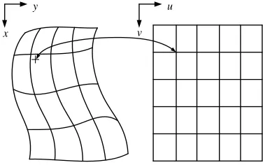
Geometric correction is to eliminate all kinds of geometric distortion caused by remote sensing image in the imaging process. Which in view of the cause of distortion and correction for geometric correction; By using the mathematical model of ground control points to deal with the distortion process for geometric precision correction, and geometric correction without considering the geometric distortion causes formation of directly using the distortion model can realize the geometric correction of remote sensing image. Figure 1 is the schematic diagram of geometric correction.
u
v y
x
Figure 1. Schematic diagram of geometric correction.
We usually adopt the geometric precision correction for geometric correction. In recent years, the application of the model in the production of Polynomial, Affine, Rational Polynomial Coefficient, spot satellite image correction, Projective Transform, Reproject and so on. This paper focuses on the characteristics of GF-2 images and analyzing the principle of each model, the final selection of the geometric correction model is Polynomial、Affine and Rational Polynomial Coefficient.
①Polynomial
Polynomial model is a kind of model which expresses the coordinate relation between the corresponding points before and after the correction. Polynomial model can be directly on the image deformation itself mathematical simulation, which can avoid imaging of space geometric process. It is a model of remote sensing image geometric correction, which has the characteristics of simple principle and fast computing speed. In the relatively flat area, the accuracy can meet the actual demand.
Its polynomial model is
x = ay = b+ a X + aY + aX+ aXY + aY + ⋯
[image:2.612.213.401.395.513.2]In the formula,(x, y) as the image plane coordinates of points;(X, Y) is the geodetic coordinates of the corresponding ground points; a and b are polynomial undetermined coefficients and it is determined by the coordinates of the control points of the image. If there are 8 undetermined coefficients of the simultaneous equation, it needs at least 4 control points.
The polynomial model is easy to calculate and the computation is small, but it ignores the image distortion caused by terrain undulation, So the polynomial model is more suitable for the image processing of the flat terrain. For the image with large relief, we can consider the polynomial model of Z, The following can be obtained after correction of polynomial
x = a+ a X + aY + aZ + aXY + aXZ + aYZ + aX+ aY+ aZ + ⋯
y = b+ bX + bY + bZ + bXY + bXZ + bYZ + bX+ bY+ bZ + ⋯ Improved polynomial model is the same as the general polynomial model calculation process, it is only need to increase the number of control points. So in the ups and downs degree different images, the appropriate improvement of polynomial order can get higher accuracy after geometric correction of remote sensing image. Because in this paper the experimental area for urban areas, so the polynomial order option 2 can be realized on geometric correction of GF - 2 image data.
②Affine
Affine transformation is based on the affine coordinate system to establish a mathematical model of a coordinate transformation, It get through coordinate translation, scale, rotation, symmetry and shear composite transform etc. Assuming the digital coordinate system is Ox′y′and geographic coordinate system is Oxy.Then, by using homogeneous coordinates, we can get the affine transformation mathematical model of the digital coordinate system into the geographic coordinate system. The model for
x y 1 = x y 1 !aa aa 00
a a 1
#
The affine transformation requires at least 3 orientation points, but the coordinates on the map are not required to be perpendicular to each other and the deformation factor in the direction of the abscissa axis is not must the same.
③Rational Polynomial Coefficient
Rational Polynomial Coefficient is the ground point geodetic coordinate of the corresponding image point coordinate, the polynomial associated with ratio so as to describe the object space and like the mathematical model of geometric relationships. Compared with the commonly used polynomial or Affine, the rational function model is actually a sensor model is more generalized and more perfect expression. It is a further generalization of polynomial, affine transformation, direct linear transformation and the collinearity equation model and it does not need to know the actual structure and process of imaging sensor, suitable for different types of sensors. At the same time, the rational function coefficients can be used to hide the imaging parameters effectively, which has been widely used in many areas in recent years.
Rational function coefficients can link the ground point geodetic coordinates (X, Y, Z) and the image point coordinates (r, c) together. The formula is as follows:
$ % &
%'r)=pp X), Y), Z) X), Y), Z)
c)=ppX), Y), Z) X), Y), Z)
pX, Y, Z = a+ a Z + aY + aX + aZY + aZX + aYX + aZ+ aY
+aX+ a ZYX + a ZY + a ZX + a YZ + a YX
+a XZ + a XY + a Z+ a Y+ a X
In the Polynomial, the coefficientai = 1,2, ⋯ ,19 Called rational function coefficients. Generally speaking, the rational function model has a high precision, so it has been the first choice of high precision geometric correction.
Geometric Correction of GF-2 Satellite Remote Sensing Image Data
[image:4.612.92.518.217.260.2]In the process of geometric correction, the flow chart is shown in figure 2.
Figure 2. Flow chart of geometric correction.
Data Preparation and Fusion
[image:4.612.121.479.367.499.2]In this paper, we choose a GF-2 satellite multispectral and true color remote sensing image data in 2016(Fig.3, fig.4). Because the GF-2 satellite remote sensing image has two images about multi spectrum and full color two images. In order to get better accuracy, the image fusion is performed before the geometric correction. The fusion results are shown in figure 5.
Figure 3. GF-2 multispectral image. Figure 4. GF-2 full color image. Figure 5. Fused image.
Geometric Correction of GF-2 Images
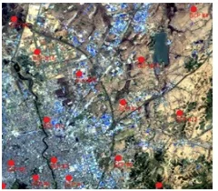
In the process of remote sensing image processing first select geometric correction model and then select of the ground control point. As the ground control point selection is a very fine process, so in the process of selecting the ground control points to find the characteristics of the terrain is very delicate. In the selection process should follow the principle of uniform distribution and overall grasp. In this paper when using the geometric correction model for geometric correction we selected 15 control points and 15 check points. The distribution is shown in Figure 6 and Figure 7.
Figure 6. Distribution of control points. Figure 7. Distribution of checkpoint.
Data preparation
Geometric correction
Ground control point collection
Image
[image:4.612.158.278.604.709.2] [image:4.612.329.456.606.709.2]After image resampling, output image after geometric correction. Compared with the original image shown in Figure 8
Figure 8. Comparison between the original image (left) and the corrected image (right).
Geometric Calibration Results and Analysis
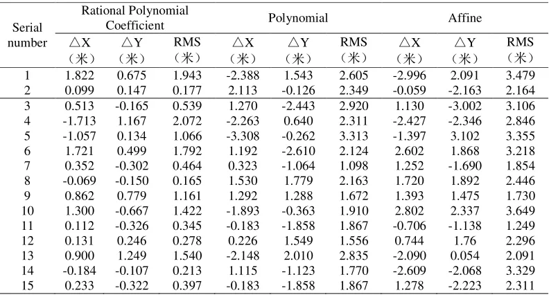
Analysis and comparison of remote sensing images based on geometric correction using the checkpoint (as shown in Table 2).It is not difficult to see, whether it is the direction of the X error, Y direction error or each point of the RMS the error of the Rational Polynomial Coefficient is less than the error of polynomial and the Affine. In the GF-2 remote sensing image geometric correction, the Rational Polynomial Coefficient can be used to correct the image more accurately and the corrected RMS error is 2.072m which is the highest correction accuracy. The RMS error of Affine is 3.649m. Through the principle we can see, although the Affine is more rigorous, the Affine requires a large number of image parameters to ensure accuracy. Due to the geometric correction can’t obtain enough of the image parameters, thus the precision of the Affine is significantly lower than that of the Rational Polynomial Coefficient. The Polynomial l itself is less than strictly the Rational Polynomial Coefficient so that in the process of image geometric correction, there is no high precision of the Rational Polynomial Coefficient. The RMS error of the Rational Polynomial Coefficient is 3.313m. Therefore, in the GF-2 remote sensing image geometric correction, the Rational Polynomial Coefficient can better achieve its geometric correction.
Table 2. Comparison of the accuracy of each model.
Serial number
Rational Polynomial
Coefficient Polynomial Affine
△X
(米) △
Y (米)
RMS (米) △
X (米) △
Y (米)
RMS (米) △
X (米) △
Y (米)
RMS (米) 1 1.822 0.675 1.943 -2.388 1.543 2.605 -2.996 2.091 3.479 2 0.099 0.147 0.177 2.113 -0.126 2.349 -0.059 -2.163 2.164 3 0.513 -0.165 0.539 1.270 -2.443 2.920 1.130 -3.002 3.106 4 -1.713 1.167 2.072 -2.263 0.640 2.311 -2.427 -2.346 2.846 5 -1.057 0.134 1.066 -3.308 -0.262 3.313 -1.397 3.102 3.355 6 1.721 0.499 1.792 1.192 -2.610 2.124 2.602 1.868 3.218 7 0.352 -0.302 0.464 0.323 -1.064 1.098 1.252 -1.690 1.854 8 -0.069 -0.150 0.165 1.530 1.779 2.163 1.720 1.892 2.446 9 0.862 0.779 1.161 1.292 1.288 1.672 1.393 1.475 1.730 10 1.300 -0.667 1.422 -1.893 -0.363 1.910 2.802 2.337 3.649 11 0.112 -0.326 0.345 -0.183 -1.858 1.867 -0.706 -1.138 1.249 12 0.131 0.246 0.278 0.226 1.549 1.556 0.744 1.76 2.296 13 0.900 1.249 1.540 -2.148 2.010 2.835 -2.090 0.054 2.091 14 -0.184 -0.107 0.213 1.115 -1.123 1.770 -2.609 -2.068 3.329 15 0.233 -0.322 0.397 -0.183 -1.858 1.867 1.278 -2.223 2.311
Conclusion
[image:5.612.108.504.441.654.2]preparation work; the Rational Polynomial Coefficient has faster operation speed than the Affine and saves the image preprocessing woke; In dealing with the urban area, the Rational Polynomial Coefficient can be more accurate for GF-2 image geometric correction. The calibration accuracy is between 0.177m and 1.249m (within two pixels), and the processed image is better and more accurate.
In summary, geometric correction in GF-2 images of the city area, the Rational Polynomial Coefficient can play its fast operation, small workload, the correction precision of the maximum for the extraction of remote sensing information to reduce the cost, save time.
However, this paper has made some achievements in the research of GF-2 remote sensing image geometric correction. Due to the limitations of the author's level, time and hardware limitations, there are still some areas need to be improved: in the Selection of the corresponding points in the image, due to artificial selection errors in the experiment will have some error accumulation, in the days after the experiment can be selected by improving the accuracy of image control points to improve the accuracy of geometric correction. In the existing model, there is no specific model for the geometric correction of GF-2 satellite images, which can be further studied in the future.
Reference
[1] Wang Xueping. Geometric Rectification and Effect Analysis of Remote Sensing Image [J]. Computer Applications and Software, 2008, 25 (9); 102-105.
[2] Yu Bowen. Geometric Correction and Fusion Research on Domestic Satellite GF-1 Data [D]. China University of Geosciences (Beijing), 2015.
[3] Jiang Yan-Huang; Yang Xue-Jun; YI Hui-Zhan. Parallel Algorithm of Geometrical Correction for Satellite Images [J]. Chinese Journal of Computers, 2004, 27 (7); 944-951.
[4] Qiu Chun-xia; Dong Qian-kun. Study on Remote Sensing Image Geometric Correction Model. Journal of Anhui Agricultural Sciences, 2015, 43 (1); 349-353.
[5] Yang Gaopan. Research and Application on Geometric Correction Methods of Remote Sensing Image [D]. Xi`an University of Architecture and Technology. 2010.
[6] Wang Jiang-hao, Ge Yong. Simulation Analysis of GCP Residuals in the Remote Sensing Image Registration [J]. Remote Sensing Technology and Application. 2011, 26 (2); 226-232.
[7] Wang Shumin; Zhang Aiwu; Hu Shaoxing; Sun Weidong; Meng Xiangang; Zhao Wenji. Geometric correction of linear push-broom hyperspectral camera side-scan imaging [J]. Infrared and Laser Engineering. 2014, 43 (2); 579-585.
[8] Nikolakopoulos K G. Comparison of nine fusion techniques for very high resolution data[J]. Photogrammetric Engineering & Remote Sensing, 2008, 74(5): 647-659.
[9] Wang Xiang, Liu Hao. Remote Sensing Image Geometric Correction Based on Digital Raster Graphic [J]. Remote Sensing Technology and Application, 2005, 05:61-64.
[10]Deng Xiaojia, Zhu Jianjun. The Geometric Rectification of Quick Bird Images [J]. Modern Surveying and Mapping, 2005, 06:40-41+44.
[11]Chen Guang-zhou. Study on Selection of Ground Control Point in Precision Geometric Correction of Remote Sensing Image [J]. Modern Surveying and Mapping, 2014, 01:14-17.
[12]Zhang Wei, Cao Guangchao. Discussion on Geometric Correction of Remote Sensing Images [J]. Value Engineering, 2011, 02:189-190.
[14]Lv Lu-Ling. A research on geometric rectification. method to remote sensing images based on ground control points. [D]. Zhejiang University, 2016.