2017 3rd International Conference on Artificial Intelligence and Industrial Engineering (AIIE 2017) ISBN: 978-1-60595-520-9
The Use of UAVs, SDN, and Augmented Reality for VANET Applications
Maria MAKOLKINA, Alexander PARAMONOV,
Andrei VLADYKO,
Roman DUNAYTSEV, Ruslan KIRICHEK
*and
Andrey KOUCHERYAVY
The Bonch-Bruevich Saint-Petersburg State University of Telecommunications, 22, Prospekt Bolshevikov, St. Petersburg, Russia
*Corresponding author
Keywords: Vehicular Ad Hoc Network (VANET), Software-Defined Networking (SDN), Unmanned Aerial Vehicle (UAV), Augmented Reality (AR), Traffic light control.
Abstract. Vehicle ad hoc networks (VANETs) enable wireless ad hoc communications for performing efficient driver assistance and car safety. However, pure VANETs may be not sufficient to address all modern challenges. The software-defined networking (SDN) concept with separate planes for data forwarding and control can effectively supplement traditional VANETs. In this paper, we propose a model for traffic light control and coordination along the route of emergency vehicles (fire, police, and ambulance), in which an unmanned aerial vehicle (UAV) acts as an SDN controller. This model can also incorporate the use of augmented reality (AR) to mitigate the risks and distortion introduced by the emergency vehicles.
Introduction
Today vehicle ad hoc networks (VANETs) is an important direction for future ad hoc networks [1]. Moreover, in recent years, such networks and their applications are commonly considered in combination with other rapidly evolving technologies. For instance, the use of unmanned aerial vehicles (UAVs) may significantly improve and/or extend functionality of VANETs [2,3]. The use of augmented reality (AR) applications also adds new capabilities to VANETs [4], especially in conjunction with UAVs [5]. Commonly the VANET architecture, including the use of UAVs and AR applications, relies on the software-defined networking (SDN) concept [6,7]. In order to select the most efficient architecture, many authors propose to use clustering methods [8].
In this paper, we propose a model for traffic light control in VANET with priority scheduling. The traffic light control in VANET has attracted a lot of attention. In contrast to traditional systems of traffic lights switching at crossroads, the traffic light control in VANET allows to not only reduce traffic delays [9] but also cut down CO2 emissions [10]. In [11], the authors reported that advanced traffic light control connected to VANET may increase crossroad capacity by 42%.
Model for Traffic Light Control in VANET with Priority Scheduling
Figure 1. The architecture of interaction of network elements.
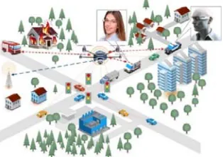
The simplest implementation of such priority driving is changing in advance all traffic lights to green along the route of this cluster. However, for a sufficiently long route this leads to unnecessary delays for other vehicles at the crossroads, as well as a long waiting time for ambulances. To reduce the duration of the waiting time for vehicles of regular clusters, as well as to ensure timely movement of ambulances, we propose a model based on the use of VANETs, AR applications, and the SDN architecture (Figure 2) [12]. Note that in the proposed architecture, the UAV performs functions of an SDN controller, peripheral modules of which are located in priority cluster vehicles. Video taken by the UAV is transmitted to AR smart glasses of the driver, which allows him/her to know the speed and other parameters of movement of ambulances and similar vehicles.
Figure 2. SDN architecture
We assume that the traveling time along the route T of the cluster of vehicles in interest is defined as the sum of transit times of individual route segments Ti
(1)
where i=1…k corresponds to a route segment, k is the total number of route segments.
The control problem is to provide a minimum delay in the arrival of a given vehicle through a road network by means of automatic traffic lights and interacting with them via a wireless network based on the IEEE 802.11p standard (VANET). The problem can be described as a task of finding the shortest route, i.e. achieve min(T) by choosing the optimal route P among the set of possible routes {P}.
For a formal description of the model, let us consider a road network in the form of a graph G,
where vertices v are intersections and arcs e are roads. In the general case, it is an oriented graph. It should be noted that this graph includes only those vertices and arcs (intersections and roads) that can be used in the route. Each arc of the graph is assigned a number characterizing the distance between crossroads or the transit time of this distance ci. The solution of the problem consists in
dynamic (interactive) search of the shortest (by distance or time) path between the points of the
k
i i
T T
[image:2.612.183.431.326.509.2]beginning and the end of the route. In order to solve this problem, we need: firstly, to define the coefficients taking into account the transit time of the route segment and the control capabilities, secondly, to determine the time to issue control signals (schedule or control plan) and, thirdly, to be
able to rebuild the route for any location of the vehicle m. We assume that the route starts at the
vertex s and ends at the vertex t.
The following algorithm is proposed:
1. The current position is the beginning of the route, m=s.
2. Find the shortest path between the current position and the end of the route,
Pmin={v1,v2,…,vk}.
3. Build the schedule of changing traffic lights to green along the route of the vehicle (control schedule), L={1, 2,…, k}.
4. Issue control signals (change traffic lights to green) for the next i-th route segment.
5. Wait for the ready (not ready) signal of the i-th route segment while moving to the i-1 route segment.
6. In case of readiness, follow to the i-th route segment, i=i+1, m=i. After passing the i-th route segment, cancel the control action (switch traffic lights to the normal operation mode). Otherwise, go to step 2.
7. If the destination is reached (m=t), then stop. Otherwise, go to step 4.
At the beginning of the algorithm, the initial position of the vehicle (step 1) should be specified, then the shortest path between the current position and the destination is defined. For this purpose, any of the known shortest path search algorithms in a graph can be used. In this case, it is recommended to use heuristic algorithms since they can significantly reduce the search time. In addition, preconfigured variants of routes can be used. After finding (selecting) the shortest path, the sequence and the time of issuing of control signals (changing traffic lights to green) on the route segments are defined. This sequence is arranged in the chronological order of the selected transmission timing of the control signals. The time (moment) of sending the control signal is selected based on the time required for the vehicle to arrive at this route segment and the time necessary to free the crossroad from passing vehicles.
(2)
where i(arr) is the arrival time of the vehicle in interest to the i-th route segment; i is the amount of
time needed to free the route segment from passing vehicles.
In the general case, i = f(a,r), where a is the traffic intensity, r is the parameters of a route
segment (i.e., an intersection or a road). The detailed description of this functional dependence is a separate task, requiring certain studies and field experiments. In our case, we assume that each of vertices of the graph is associated with a known function fi(a). Such a function can be specified, for
example, by a data table obtained experimentally. The traffic intensity a can be determined by different methods: statistically (according to the schedule), with the help of monitoring tools (stationary video cameras, cameras placed on UAVs, messages from other means of monitoring real traffic).
The efficiency of the control actions can be easily estimated by considering the route model as a multi-phase queuing system, where the number of phases is equal to the number of route segments, and vehicles act as a flow of customers at the entrance of the server. For example, with the exponential distribution of transit times (passing of a route segment) and stationary Poisson process, the route passing time can be defined as
(3)
where is the traffic load on the i-th phase; i is the traffic intensity on the i-th phase; is
the transit time of the i-th route segment; k is the total number of route segments.
i
arr i
i t
t max ( ),
k i i i iit t
T
1 1
i i
i
tWhen a control action on the i-th segment is applied, the value of changes, namely, it becomes smaller. As a result, the value of T decreases, which is easy to see according to the expression given above. Thus, the travel time along the route decreases, while the degree of this decrease can be specified by scheduling control actions. This is achieved by the timely increase in the capacity of route segments, up to the complete release of the route segments from passing vehicles. The main advantage of this method is that control actions (change traffic lights to green) are carried out during the minimum required time, which allows minimizing the impact on the traffic load.
Summary
In this paper, priority scheduling for emergency vehicles with special signals is considered. Often this creates inconvenience to other drivers, because they have to wait for a long time while the motorcade passes. This is due to the fact that traffic lights at crossroads along the route are switched long before the approach of such vehicles with special signals.
In this paper, we propose a model for the timely management of traffic lights. To implement control functions, the VANET technology is chosen as the basis. For greater scalability and flexibility, it is supplemented with the SDN technology, where a UAV is used as an SDN controller. To visualize the situation and improve control, the model uses the AR technology. A video stream received from the UAV can be supplemented with the required information such as, for example, the speed and intensity of traffic along the intersecting streets, the dimensions of neighboring vehicles, etc.
Within the proposed model, an algorithm for finding the optimal route to minimize the route passing time for a given destination point is developed. Future work includes conducting experiments on a model network to verify the model and analyze the network characteristics, as well as extending the functions of traffic management by using the AR technology [13, 14, 15].
Acknowledgement
This research was financially supported by the Ministry of Education and Science of the Russian Federation in the framework of the Federal Target Program «Research and development on priority directions of scientific technological complex of Russia for 2014-2020» (the Agreement number 14.604.21.0165, unique identifier project RFMEFI60417X0165).
References
[1] J. Jakubiak, Y. Koucheryavy, State of the Art and Research Challenges for VANETs, in: Proc.
5th IEEE Consumer Communications and Networking Conference, 2008, pp. 912-916.
[2] L. Gupta, R. Jain, G. Vaszkun, Survey of Important Issues in UAV Communication Networks,
IEEE Communications Surveys and Tutorials, 18 (2016) 1123-1152.
[3] P. Shilin, R. Kirichek, A. Paramonov, A. Koucheryavy, Connectivity of VANET Segments
using UAV, Lecture Notes in Computer Science, 9870 (2016) 492-500.
[4] A. Croatti, A. Ricci, M. Viroli, Towards a Mobile Augmented Reality System for Emergency
Management: The Case of SAFE, International Journal of Distributed Systems and Technologies, 8 (2017) 46-58.
[5] M. Makolkina, A. Koucheryavy, A. Paramonov, Investigation of Traffic Pattern for the
Augmented Reality Applications, Lecture Notes in Computer Science, 10372 (2017) 233-246.
[6] A. Hussein et al. SDN VANETs in 5G: An Architecture for Resilient Security Services, in:
Proc. Fourth International Conference on Software Defined Systems (SDS), 2017, pp. 67-74. [7] E. Kalogeiton, Z. Zhao, T. Braun, Is SDN the Solution for NDN-VANETs?, in: Proc. 16th Annual Mediterranean Ad Hoc Networking Workshop, 2017, pp. 1-6.
[8] X. Duan, Y. Liu, X. Wang. SDN Enabled 5G-VANET: Adaptive Vehicle Clustering and Beamformed Transmission for Aggregated Traffic, IEEE Communications Magazine, 55 (2017) 120-127.
[9] M.K. Abbas et al. Traffic light control using VANET system architecture, in: Proc. National
Postgraduate Conference (NPC), 2011, pp. 1-6.
[10] Z. Xiao et al. An intelligent traffic light control approach for reducing vehicles CO2 emissions
in VANET, in: Proc. 12th International Conference on Fuzzy Systems and Knowledge Discovery (FSKD), 2015, pp. 2070-2075.
[11] T. Herendi, P. Malakhaltsev, VANETs overview, advanced traffic light control, in: Proc. 9th
International Conference on Applied Informatics, 2014, pp. 321–328.
[12] A. Volkov, A. Khakimov, A. Muthanna, R. Kirichek, A. Vladyko, A. Koucheryavy,
Interaction of the IoT Traffic Generated by a Smart City Segment with SDN Core Network, Lecture Notes in Computer Science, 10372 (2017) 115-126.
[13] R. Kirichek, A. Koucheryavy, Internet of things laboratory test bed, Lecture Notes in Electrical Engineering, 348 (2016) 485-494.
[14] R. Kirichek, A. Vladyko, M. Zakharov, A. Koucheryavy, Model networks for internet of
things and SDN, in: Proc. 18th International Conference on Advanced Communication Technology (ICACT), 2016, pp. 76-79.
[15] A. Vladyko, A. Muthanna, R. Kirichek, Comprehensive SDN testing based on model network,