Journal of Chemical and Pharmaceutical Research, 2014, 6(7):2655-2659
Research Article
CODEN(USA) : JCPRC5
ISSN : 0975-7384
Integrated security information system based on wireless sensor networks
Lei Zhang and Shanhong Zhu
School of Computer and Information Engineering, Xinxiang university, Henan, China
_____________________________________________________________________________________________
ABSTRACT
This paper introduces the research on the security location, Based on the wireless sensor network technology,it can give a new way to get information of the security operators. The hardware designed with the CC2431 SOC, it finished the design of the wireless sensor network devices. These devices are used to construct the wireless sensor network under the mine. It can give effective helps to the rescue works by gathering the environment data and personal positioning when occurrence of the coalmine accident.
Key words: wireless sensor network; CC2431; personal positioning; Location
_____________________________________________________________________________________________
INTRODUCTION
At present, most of the mine safety monitoring systems mainly adopt the way of cable for data transmission, once the accident comes up, equipment and cables will often be damaged for search and rescue after the mine disaster providing no effective information, because the ground monitoring personnel can not grasp the mine personnel assignments and distribution, so the person in distress of disaster relief, safe rescue the efficiency is low, the rescue effect is poor.
Fig 1 system structure
Anderson et al., constructs a three-dimensional from multiple cameras to obtain the outline of human video system, using optical fiber sensor and the acoustic sensor drop fall vibration signals generated by the deployment of collection These two skills are medium to good application in the laboratory, but cannot be used for special occasions, such as outdoor or the special indoor, such as the coal mine environment, closed hospital, etc. so the paper proposed the security information system.
This security information system improved the internal security for mine construction enterprises, their budget management, compensation management and implementation details of evaluation, and promoted CBM for mine construction enterprises. A range of modules were provided by the system, including production progress management, project material management, mechanical and electrical equipment management, human resource management budget management, and integrated security statements etc., which is shown in Figure 1.
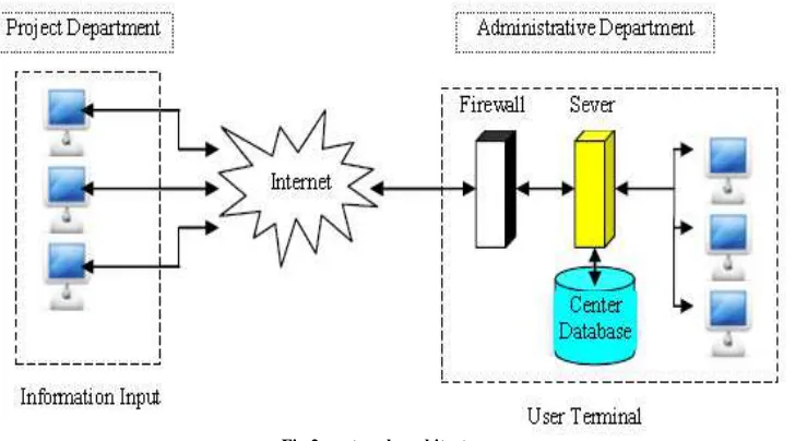
Internet was used as a support for the system to ensure the information exchange within enterprises. The system network architecture and hierarchical structure is shown in Figure 3.
Fig 2 network architecture
Distributed compressed sensing model based on WSN
In the WSN to collect data through various Sink node sensing sensor nodes, and monitoring the event source S to estimate the area, making the distortion estimation results to meet the requirements of WSN applications. Figure 1 shows the compressed sensing based spatial correlation of distributed.
Due to the WSN nodes are densely distributed in Sj and between Sj and S in the presence of varying degrees of
spatial correlation. Therefore, to meet the requirements of distortion, by determining the scope of the EA event area, while taking advantage of the perception of spatial data between WSN node correlation data compression and reconstruction, has a very important significance in the WSN.
Analysis and restructuring of security informatization-driven process
The principle of the optimization design for mine security enterprises was to realize the restructuring of mine enterprise businesses under the collaboration of market chains and to materialize the optimal human-project combination and product/service performance. In this way, each process could directly serve for the project object. Besides, each basic decision unit was assigned with corresponding subsidiary autonomy, and the outcome of each process could be measured by currencies. This could further evaluate the quality, costs and benefits, and optimize the internal resource allocation via the structural integration, business process integration and resource integration. The optimization design facilitated the reduction of construction costs and the improvement of beneficial efficiency in enterprises.
[image:2.595.129.493.238.440.2]All functions of this system were designed on the basis of modules so that users could flexibly configure each module to their needs. The efficient data processing ability and complete data backup mechanism effectively reduced the network flow during data transmission, which shortened the system response time and guaranteed the effectiveness and accuracy of data. Users could easily operate the system after training.
The overall structure of the data terminal
The system structure block diagram is shown in Figure 1, here, ME2-O2 is an oxygen concentration sensor, for acquiring down-hole oxygen concentration data, and which outputs a current signal proportional to the concentration of oxygen, MH-440V/D is the methane concentration sensor for detecting underground gas concentrations, DS1631 is a digital temperature sensor for miner temperature acquisition, HK2000A pulse sensor is used to capture the heart of miners. CC2431 is a ZigBee wireless location chips, during 2.4G ISM band wireless achieving data transmission function, which integrates a 51-core chip microcontroller with a 14bit A /D. The framework structure of the data terminal, CC2431 as to the core components, is shown in Figure 3.
Fig.3the system structure block diagram
In Figure 3, oxygen concentration and gas concentration measurement devices, mainly detect for underground miners usually work environment the oxygen concentration and gas concentration. When the gas exceeds safe limits, sound and light alarm, when faced with mine disaster, real-time environmental parameters in which the trapped miners timely deliveries to the command center, easy to carry out rescue work.
ZigBee-wireless location network based CC2431
Construction of wireless location network
TI produces location engine CC2431with hardware, based on RSSI ( Received Signal Strength Indicator ) technology, the location of the own node can be accurately calculated based on the received signal strength and the known reference point, and its location information is transmitted to the receiving end, achieving 3 ~ 5m positioning accuracy and resolution of 0.25m .It operates in the 2.4GHz ISM band, on-chip integration of ZigBee frequency (RF) front-end , memory, and 8051 controllers.
Wireless Location System is composed of two kinds of nodes: a plurality of reference nodes and mobile nodes. The reference node is a fixed node, its position is known. This node can send data packets to each other information on each location through the Internet.The mobile node receives the data from the respective reference nodes, by measuring the received signal strength and the position information obtained from the reference node to calculate the own position by location engine.Figure 4 is a block diagram of the RSSI positioning system.
Fig. 4 Positioning system block diagram
The role of each part is as follows:
(1) Host computer: a host connects to the reference node through a gateway, to manage the reference node such as setting coordinates of the reference node, and receives the data from the reference node via a gateway, on the screen can observe the location of each mobile node and various information collected by the mobile node.
composedof CC2340 and reference node, the mobile node collected to transmit to the host.
(3) The reference node: fixed coordinate specified by the user, and supplies the coordinates and the average RSSI value for the mobile node.
(4) The mobile node: having internal positioning engine, the coordinates of its own can be calculated based on a fixed coordinates value of the reference RSSI node, and sends the coordinates , ID number to the gateway .
To ensure accuracy, multiple reference nodes are arranged on both sides of the roadway, forming a wireless network.Miners nodes computes their position in the located network, and their position, ID, environmental information and miners vital signs and other information, real-time wireless upload to the host computer.On a large screen in the center of the ground control room, computer images clearly indicate precise location of each miner, accuracy 2.5m2.
Location algorithm based on RSSI
CC2431 positioning algorithm is based on the received RSSI (received signal strength indication) value. RSSI value will decrease with increasing distance:
)
log
10
(
n
10d
A
RSSI
=
−
+
(1)Where, n is signal propagation constant, d is the distance between the sender, A issignal strength a meter far from the sender.
For mobile node M (x, y), the distance equation between two points in the plane, the equation can be obtained:
= − + − − + − 2 2 1 2 2 2 1 2 1 ) ( ) ( ) ( ) ( n n n d M d y Y x X M y Y x
X (2)
A linear transformation represented by the formula (2):
B y x A =
2 (3)
− − − − = −
− n n
n n n Y Y Xn X M M Y Y X X A 1 1 1 1 + − + − − + − + − − = − −
−12 2 12 2 12
2 2 1 2 2 1 2 2 1 2 n n n n n n n n n Y Y X X d d Y Y X X d d B
Using the least squares method to get the coordinates of the mobile node:
B A A A y
x T 1 T
) ( 2 1 − = (4) CONCLUSION
RSSI-based location data terminal Underground staff is successfully developed, resolving the miners accurate positioning issues in time when the mine disaster.More importantly, real-time vital signs every miner and its surrounding environment information can be able to be got for rescue work smoothly to provide effective help.With this system, the ground control personnel can grasp the operation and distribution of underground personnel to improve safety ambulance efficiency with some promotional value.
REFERENCES
[1] Liu Yang, Yang Jieming. Study on position method for underpit operators based on CC2431[J]. Coal Mine
Machinery, 31(6): 49-51
[2] Xu Zhijing, Hu Bo. Wireless positioning technology research based on CC2431[J]. Electronic Design
Engineering, 2009(10): 10-12
[3] Lizhi, Liu Jianhui. Research of mine rescue robots’ communication based on the ZigBee technology[J]. Science
Technology and Engineering, 2008(7): 34-36