Jle:paxtmenf
of
~cienfific anb 6lnbuztriar ~ezearcf?.GEOLOGIOAT.--J
MEMOIRS.
ME
M 0 I R No.
1.
THE GEOlOGY. OF THE MAlVERN
HillS.
By R. SPEIGHT, M.Sc., F.G.S., F.Am.G.S., Curator of the Canterbury Museum.
With a Section on the Physical and Chemical Properties of the Clays and Sands, by S. PAGE, B.Sc.
WITH MAP AND SECTIONS, PANORAMIC SKETCHES, AND PHOTOGRAPHS.
WELLINGTON
BY AUTHORITY: W. A. G. SKINNER, GOVERNMENT PRINTER.
A. Introductory
B. General Physiography of the Area
C. Stratigraphy
I. Pre-Senonian
(a) Triassic Sedimentaries and Volcanics, and Lower Jurassic Sedimentarias (b) Upper Jurassic or Lower Cretaceous Volcanics ..
(i) Rhyolites (ii) Andesites
II. Senonian
(a) Coal-measures
(i) Hororata-Glentunnel-Sheffield Area (ii) Outliers
Cordy's Flat, Hart's, St. Helens, Phillips Saddle, Rockwood, Hawkins Valley, Kowai Valley, High Peak, Acheron, Rakaia Gorge.
(b) Age of the Beds
III. Post-Senonian
(a) Igneous Rocks-Effusives and Intrusives (b) Post-Tertiary-Gravels, &e ...
D. Economic Geology
(a) Coals
(b) Clays and Sands
(c) Building-stone
( rl) Metalliferous Minerals
E. Bibliography
Index
PAGE
1
1
3
4 4 12
14
16 17 17 17 34
44 44 46 52
53 53
56
67 68
69
THE GEOLOGY OF THE MALVERN HILLS.
A. INTRODUCTORY.
IN the early days of geological work in New Zealand the Malvern Hills district attracted considerable attention, chiefly, perhaps, since it promised to provide a considerable amount of coal for a region deficient in fuel, but also because it furnished points of purely scientific interest. The latter were fully recognized by Dr. von Haast, who was then Provincial Geologist for Canterbury, and he spent much time and trouble in attempting to elucidate its geological features and to determine the precise economic possibilities of the area. Although this work was done fifty years ago, it is surprising how well it has stood the test of time. The records of his work are to be found in his reports to the Provincial Government, and also in the earlier reports of the New Zealand Geological Survey. In addition to Haast's pioneer work, special mention must be made of that done by Captain Hutton when he was on the Survey and later, and also of that by S. Herbert Cox. The accounts given by these early geologists still furnish the basis of subsequent work, and I must personally express my indebted-ness to them for suggestions so numerous that it is impossible to mention them further. Quite recently most important palooontological work has been carried out by Woods and Trechmann, and many points connected with the chemical aspects of the coal problem have been thoroughly dealt with by Evans. 'Ihe fact that the latest accoun~, of the area was given by S. H. Cox in 1884-that is, forty years ago-has prompted me to redescribe it in the light of more modern knowledge, and hence the following account.
B. GENERAL PHYSIOGRAPHY.
FoR the purpose of this paper the area called the Malvern Hills will be considered as that lying to the south-east of Big Ben Range, and forming the basin of the Upper Selwyn and its tributaries, the Hawkins, Waianianiwha, Wairere, and the Hororata. Since the main matter for consideration is concerned with the nature and stratigraphy of the Cretaceous coal-measures occurring in the district, there are three other areas which must naturally be considered with it-viz., the outliers at Benmore,
the Acheron, and Rakaia Gorge. ·
As has been explained in a previous paper (Speight, 1924), the main surface features of the area arise from fault-movements which have affected a peneplain developed out of Trias-Jura rocks covered with a thin veneer of weak Cretaceous beds. These movements have resulted in the formation of a series of subparallel more or less continuous ridges, with intervening strips, whose orientation has determined initially the directions of the main streams. Commencing from the north-west, these faulted strips are as follows :
-1. The Benmore Area, with a possible continuation on the line of the Acheron Valley. South-east of this lies the mass of the Big Ben Range, a long even-topped ridge, rising to 5,436 ft. in Benmore, with lower foothills farther south-east. Then follows
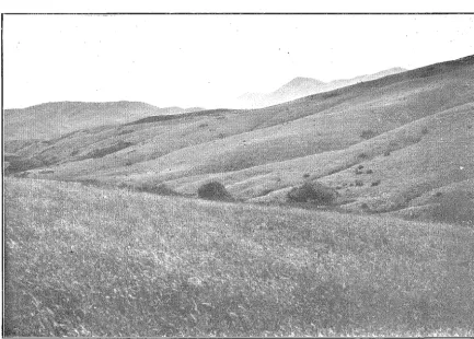
2. The High Peale Area, occupying a portion of the Upper Selwyn basin and reaching north- east across the Upper Hawkins. South-east of this extends a well-defined ridge, of which the following are the chief features, commencing from the south-west end of the range: Round Top (2,917 ft.), Snowy Peak (2,983 ft.), High Peak (3,176 ft.), Four Point Range (2,414 ft.), Flagpole Hill (2,939 ft.), and the Black Hills'(2,264 ft.). The Selwyn has cut its gorge between the last two of these, (See panorama.)
3. The Kowai Area, bounded on the south by the Russell Range (3,086 ft.), which forms a kind of splinter connecting the foothills of Big Ben with the north -east end of the Round Top- Flagpole- Black Hills ridge.
4. The Rockwoocl A1·ea, occupying the upper valley of the Hororata and lying between Snowy Peak, High Peak, and a ridge extending south-west from Pullwool Peak (2,404 ft.).
5. 001·dy' s Flat Area, which lies between the Four Point Range- Flagpole Hill- Black Hills ridge and the broken ridge of which Mount Misery (1,910 ft.) and the Cairn Range (1,634 ft.) are segments. This area perhaps extends across Pig Saddle (Knight's Saddle) to the west of Abner's Head and on to the north-east under Russell's Flat, where it is masked by recent river-gravels, except at the northern corner, close to the Township of Springfield.
To the south-east of the Pull wool Peak- Mount Misery- Cairn Range- Abner's Head ridge lies the main area of coal-measures, stretching from the Hororata River to the Hawkins, near Sheffield, a belt about 13 miles in length, with a maximum width of 4 miles, the latter corresponding practically with the line of railway between Coalgate and Whitecli:ffs.
The following streams are associated with these strips of country :
-(1) Macfarlane's Stream, which runs north-east to the Upper Kawai, behind Big Ben, and probably the Acheron, which discharges south-west to the Rakaia.
(2) The Upper Selwyn, which runs north-east and receives the greater part of its water from the south-east slopes of Big Ben.
(3) The Kawai, in its middle and lower course, running north-east to the Waimakariri. (4) The Upper Hororata, which runs almost south past the Rockwood Station.
(5) The Glendore Stream, which runs,north-east past Mount Misery to join the Selwyn near Whitecli:ffs.
While attributing the major outstanding surface features of the area to faulting, it should be noted that the deformational movements did not in all cases result in rupture, but rather warping. In the D;Orth-east, especially in the vicinity of Abner's Head and the Black Hills, also on the northern flank of the Cairn Range, this is most marked. Stripped surfaces occur here in such a perfect condition that it is reasonable to infer not only the former presence of covering beds, but also their dip and strike from the slope of these surfaces. This may seem somewhat doubtfU;l evidence, but when one sees remnants of the covering beds associated with such surfaces, and then again the surfaces without the covering beds, the conclusions drawn therefrom are hardly as far-fetched as persons unacquainted with the locality might imagine. As a result of observations on these I have concluded that the faulting movements lost somewhat of their intensity and graded into folds in the north-east part of the area, although there is certainly evidence that some faulting existed there. The association of faults with folds is a characteristic feature of many parts of the submontane area of New Zealand, and it may have been characteristic of the montane area, but we cannot say, since the covering beds, from whose position inferences may most readily be drawn, have been stripped away almost completely.
The only streams that have been powerful enough to break across the ridges which bound them on the south-east are the Selwyn and Hawkins, the former aided, no doubt, by the interference of the glaciers coming from the direction of the Rakaia Valley ; otherwise the drainage has been in a north-easterly or a south-westerly direction. In the area occupied definitely by the coal- measures the control of structure on the directions of the subordinate streams is very marked.
There is decided evidence of glaciation in the High Peak Valley and on the western part of the area under consideration. Not only did the Rakaia Glacier cover the plains in the vicinity of the point where it issued on to them with morainic and fluvio-morainic material, but there is undoubted proof that the ice-stream crossed the Rockwood Range at two points-viz., at Middle Saddle, which lies between High Peak and Snowy Peak, and also between Snowy Peak and Round Top. This conclusion is based not only on the smoothed landscape features, but on the fact that massive blocks of greywacke up to 20 tons in weight occur in many parts of the range, resting on a surface consisting of andesite or of rhyolite. , It is likely that the whole of the western end of this range was covered with glacier-ice, and, if so, it must have cascaded over into the low country between Rockwood and-the Point, a.nd possibly may have filled and-the Rockwood Valley, since and-the ridge extending westward from Pullwool Peak shows features attributable to glaciation; and, besides, on the flat country south-east of this there are huge blocks of rhyolite-one of which weighs 80 tons-whose presence in the position in which they occur can only be due to the action of ice.
In general, it may be stated that the ice extended from the rl.irection of the Rakaia River to the line of the Hororata River, since all the intervening country itl covered with material of glacial origin
+ +
9
•
PaJ?
bra-nJ
a
o+
L
~Y'
Q"\5cap~/
Sourh
h_y
iYE.sf
fo
l'forfh
M~~
0/..5-f-
ar,
ce..s E..sftmarleoi //7 nule..s or cpa/n..s.~ z~s· {
B e a r / ' 7 g.s
z.Ss "
zf.o o2.bs
0+ + •
,...--... ---..., ~ r - - ' - - - : : : : . J
~~~---~
7'C o q / ~ o r rn cr 1- 1\0 n . s -/ -
-+ + .. .r \ ~
Panorama
'
' '
+
...
ro88/L
Pt..RIN
PANORAMIC SKETCH ILLUSTRATING FIGS.
1
&
2.
z7o
ods
oI
Z&o o
:?.I.S"
t
Whether the Rakaia ice extended beyond the line of the Hororata River is doubtful, but the down country between the Glenroy Saddle and Rockwood is covered with a thick veneer of gravel, composed mostly of greywacke but occasionally containing rhyolite, some of the stones being up to 4 ft. in diameter, suggesting either glacial action or the presence of very powerful streams issuing from an ice front in close proximity. All over the down country which is characteristic of the area where the coal occurs in greatest abundance is a heavy coating of this gravel up to 70ft. in thick-ness, and perhaps more. This materially interferes with prospecting, except by boring and actual mining operations. The surface of the ground where this lies exhibits a remarkable uniform level surface, which the present strea.ms have rlissected, cutting down into it for a depth which varies from 70ft. to 375ft., the greater depth being, as a rule, characteristic of the surface adjacent to the grey-wacke and rhyolite substratum in the north-west part of the area.
This dissection has reached an early mature stage, so that, while the tributary valleys are wide, with very flat floors, large undissected remnants of the original smface still persist. The Selwyn River still runs on a very steep gradient, but it is so clogged with shingle that it is an aggrading stream, and this aggradation has resulted in the ponding-back of tributaries such as the Glendore, W airere, and W aianianiwha, and the formation of extensive swamps ou their floors. The W airere Swamp, once known as the Thousand Acre Swamp, has now been drained and converted into good pastoral country.
The glacial featmes of the northern part of the area present some difficulty. As far as I can see, there is no evidence whatsoever that ice ever came through the Selwyn Gorge, but in the vicinity of Springfield and Sheffield and on the northern slopes of the Abner's Head Range there occurs in places a deposit formed of large subangular blocks of greywacke up to 5 ft. in length, whose origin can hardly be. credited to any other action than that o£ glaciers. The largest deposit is that fringing the northern base of Abner's Hea,d for a distance of at least a mile. It apparently rests on gravels of a series older than those at present being laid down in the river-beds. This occurrence is apparently separated by a depression from the other deposits on the flanks of the range, and, if glacial, it is either a lateral moraine or a terminal one. Analogous to this is the deposit forming Little Racecourse Hill, in the vicinity of the Sheffield Railway-station. The size of the boulders suggests that this hill is formed from moraine or from fluvio-morainic material laid down quite close to the termina,l face of a glacier. Similar hills near Springfield may have been formed in the same way.
Farther up the Hawkins Valley, on the spurs of the Black Hills, there are coarse breccias possibly attributable to gla,ciation. Their location suggests that they were due to a glacier which came from the direction of the Upper Hawkins past the Dalethorpe Homestead. If this is so, then it may have been a distributary from the main Rakaia glacier, which came down the High Peak Valley and crossed the low divide~this is practically non-existent as a divide--into the Hawkins basin. I can see no difficulty in this explanation, and it is certa,inly as satisfactory as to attribute the deposits to. the former extended W aimakariri glacier. All the same, the conclusion that these deposits are glacial is based only on the shape, size, and position of the boulders, unsupported by other evidence, and so I cannot view it as entirely convincing. No doubt large rivers issuing from the face of the ancient glacier have swept away a good deal of the old moraines and have left mere remnants, so that perhaps the absence of other evidence, such as the occurrence of crescentic heaps of angular material across the old front of the glacier, &c., is not so remarkable~in fact, it is what might have been expected.
If the deposits are glacial, then the ice must have extended either from the direction of the Hawkins or from the W aimakariri nearly as far a,s Sheffield.
C.
STRATIGRAPHY.
NoTE.~In order to illustrate the general stratigraphical relations of the d!fferent beds that occur in the area, a. geological map is given, as well as sections~ three in number- oriented a.cross the general grain of the country, approximately parallel to the clip. No further references to these will be made in the text, but a number of smaller sections illustrative of limited areas are given, and these will be referred to as necessity arises. In the case of sections passing through the Triassic greywa,ckes, &c., it should be pointed out that in that part of the sections the representation of the dip of the heds is largely diagrammatic, and not intende~l to show thei~ true relationship, since the be.ds have been subjected to folding movements, the preCise effect of whiCh has not as yet been determmed.
I.
PRE-SENONIAN ROCKS.
(a) TRIASSIC AND JURASSIC. (See Sections Nos. l, 2, 3, 4.)
Although the chief reason for this paper concerns the coal-measures, some reference should be made to the basement rocks of the area. These are best developed in the ridge which divides the High Peak area from the main area where.the coal-measures occur. At the western end of this ridge the rocks are exclusively volcanics-rhyolites and"andesites; while towards the north-east sedimen-taries are developed and form the Four Point Range, Flagpole Hill, the Black Hills, the Cairn Range, and the ridge of which Abner's Head is the domi1iant ·feature. There is also a small inlier in the creek running from the Brockley Coal-mine, and· anbther in the Hororata River near Glenroy.
The rocks include greywackes, slaty 'shales; carbonaceous shales, sandstones, conglomerates, and interstratified beds of diabase ash and related volcanics. Whether the whole series is part of one conformable set of beds is a matter of opinion; but I am persuaded that two separate series occur. There are differences in lithological character, and also differences in strike and dip within small areas between beds which show divergence in lithological character ; . and:, further-and this seems most important-over wide areas there are conglomerates containing· 'grey-Wacke pebbles indicating some-thing more than an interformational unconformity between the two sets of beds.
The greater part of the underlying series consists of greywacke Of a' m:Yrmal type, but interstratifiecl with it are slaty shales, and again jasperoicl rocks or reddish shales'which owe their distinctive colour to ferric oxide. Some of these are of extremely fine grain;· ·.'The· strike of these beds is north-east and south-west, but local variations about this mean are frequent; and the dip is usually high, often vertical. In no place have I seen these beds with a flat clip, so that t/11s'arrangement implies either an enormous thickness of the beds or that they are involved in isoClinal' folds with closely appressed limbs inclined at high angles. I think that the latter alternative is the correct one; but no definite repetition of the beds has been determined up to the present, although t'jle occurrence of ash-beds on parallel lines does suggest it ; all the same, I quite expect that definite ':tepea:ted horizons will be made
out in the future. · ·
The best section through these beds is given by the gorge of the Selwyn River, which cuts across the strike almost at right angles. The direction of the beds in the gorge controls to some extent the course of the river, in that the longer reaches are generally parallel with the strike, and the shorter reaches across it; but the general effect is that the river cuts across the beds. The strike in this part of the area is more to the east than generally, being usually between east-north-east and east, so that the line of the range from Flagpole Hill to Abner's Head is approximately that of the strike of the beds. Almost invariably they dip at high angles, from 70° to vertical; very rarely the angle is as low as 40°, and then it appears to be quite local and in close proximity to some dislocation ci:t. deformatitin of the beds. In the lower part of the gorge the dip is to the north, but near the upper end;· clast;~ to ,the old copper-drives, the dip is to the south, but at very high angles-in fact, it is hard to sa.y
a.t
times ~hether it is to the south or not. As the ash-beds are to some extent involved in this southerly dip', th,e q11estio:p. of their repetition in this section of the gorge was considered carefully; but there is:'iif
sigri of)t in the position in which they would occur were this change in direction of dip due to . acute' folding 'ofthe same beds, so that I am inclined to think tha.t the southerly direction of dip is nierely due to slight
overturning of the beds without repetition. · . ·' · , ·
In the section through the gorge there is definite evidence of faulting, of the presimce of crush-belts (the latter sometimes associated with local variations in dip and strike), and of a frequent waviness in the stratification.
The same general features of these beds appear to occur on Abner's Head, where the strike is approximately the same and the dips high ; but in a quarry on the road over to the saddle to the east of this hill the clip is definitely low, being about 40°.
:-~
~
~
~
r
I'>
~
~-(h
~-2l
-·~Sill
~
i
r
Cl..ea.i:IWzgs Gully
01 Bas . .J?y'k~
~:} RlgT. J?yl<RS
<:
~
~ ),
r
. I
~
(J,(\) Cl)
~ (AII~6l-~=-t-
·
~ ~~
·=:~-,~ ~ ~~
-=
~ ~ ~cl'
----~ "S----~"' ~ ~~. ~ "i
I~
~ ~ • CO\
~ ~
~
':l:J-~ ':l:J-~
r
~
!: ~ ~ !i>
~
.·:"\ ~ /
':::!. ;_/,
en <:s "'
/),§
111~ ~
~- ~
::z::,~ ~
~ ~
~- ~
~
~
~
C/1
~
pl
'::,._ (Upper) .
g
~
~
ill
~
:lJ
~-:2 ;E
The relationship or the greywackes to the overlying beds in typical localities will now be considered.
The first case is that occurring on the western end of the Cairn Range, immediately at the back of Captain Woodcock's house. The greywackes here have a north and south strike, with a vertical dip ; but immediately north-east of this there are conglomerates containing greywacke pebbles, striking north-east and dipping south-east. Farther on the pebbles become finer, the beds retaining the same strike and dip, but are succeeded by shales, with plant-remains, dipping north-west. In this section the Cairn Range probably has the form of an anticline with a flanking syncline to the north-west, and the north-west limb of the anticline is the most clearly exposed ; still, the covering of soil and surface slip renders the precise stratigraphy difficult to determine. This locality is interesting as being the spot which furnished the plant fossils described by Arber (1917, p. 11).
The lowest beds exposed on the face of the hill are conglomerates, but at the spot where the plant fossils occur most plentifully, which is near the crest of the hill, the following sequence is exposed in ascending order :
-1. Conglomerates with pebbles of greywacke. 2. Sandstone, brownish, with calcite veinlets. 3. Carbonaceous shales, 12ft.
4. Sandy shales with impressions of leaves and stems of trees-the most prolific plant horizon, and the one from which nearly all the plant fossils described by Arber were obtained. 5. Brownish, hard, indurated sandstone.
At various points on the hillside similar beds appear, the succession of shales and sandstones being repeated several times-probably at least four times. At several points short adits have been driven on the carbonaceous layers in the hopes of finding payable coal, but without success. Wherever the beds are clearly visible conglomerates form the lowest member.
They strike east-north-east and dip north-north-west at angles of from 10° to 15°; but on the sides and head of the gully which comes from the north-west corner of the Cairn Range there is a reversal of clip, but only the uppermost beds of the northerly wing of the syncline are exposed, and these consist of a soft somewhat friable sandstone, like a freestone, composed of loosely cemented quartz-grains. In these beds Haast found the fossil fern Polypodittm Hochstetteri Ung. =Cladophlebis australis (Morris). Arber considered the underlying plant-beds containing this fossil as probably Lower Jurassic, but it also occurs fossil in beds of Neocomian age (lac. cit., p. 18) at Waikato Heads, Auckland. However, the general suite of fossils suggests a Lower Jurassic age, and as there is no apparent uncon-formity they are without doubt all of that age.
The country to the east of this, towards the head of Bush Gully and along the southern flank of the Cairn Range, was carefully examined in order to see how far these Jurassic beds extend. (See Section No. 5.) The crest of the range appears to be of normal greywacke, but it is flanked to the south for some distance by beds which belong to the Jurassic Series. Just above the bush there is a sandstone similar to that on the end of the range facing the Selwyn, with occasional narrow beds. of bright coal and of carbonaceous shale, while on the east side of the gully is a :fine conglomerate with greywacke pebbles, clipping to the north (?). On the spur west of the bush there is a conglomerate composed of greywacke pebbles closely resembling the other Jurassic conglomerates in appearance, which strikes N. 55° E. and dips south-easterly at an angle of 40°. A little farther down the spur is a rhyolite-bearing conglomerate striking slightly more to the east and with the saine clip. The practical accordance in the dip and strike of the two beds, in spite of the lithological resemblance to the Jurassic conglomerates, makes me conclude that they belong to the same series, and that there· fore the greywacke conglomerate should be assigned to the Senonian Series. The absence of the rhyolite constituent is not, after all, so remarkable, since a greywacke or similar land must have. been in close proximity to the area when the beds were laid clown. If, however, the bed belongs to the Jurassic Series, then an anticline must flank the syncline to the south; and there is some indication of this farther east, for on a spur to the east of the bush the sandstone is well developed and perhaps bent up into an anticline whose axis strikes east-north-east and west-south-west, flanked by a syncline to the north whose northern limb rests on greywacke. This cannot be stated for ~ertain, since exposures giving undoubted indicati0ns of clip and strike are impossible to get owing to the covering of soil, surface debris, and tangled scrub. I have therefore given the section (No. 1) on the supposition that there is no flanking anticline.
On the western side o£ the Selwyn River, opposite the end of the Cairn :Range,"on what is called the Manuka Range, there is a notable development of these beds, practically in the same alignment if due allowa,nce he made for the shift of the outcrops owing to the Cairn Range-Misery Fault. In a slip at the bottom of a small creek coming from the range there lies on the basement beds of normal greywacke, as exposed on the end of the range near the river, the following sequence in ascending
order:-1. Compact sandstone with plant-stems. 2. ArD'illite, much weathered and crumbly.
3. Br~wn coaly shale, dipping north at an angle of 30°. 4. Argillite with ferruginous concretions.
Some dista.nce above this stratigraphically the following occur :-5. Fine sandy conglomerate.
6. Coarse incoherent sandstone and conglomerate, containing greywacke pebbles, striking E. 10° N. and with a northerly dip.
7. Grey wacke conglomerate.
The ridge is capped with these beds for some distance to the west, and in places they extend well down the southern face nearly to the level of the flat occupied by Middle Creek;. (See Section No. 4, p. 19.) On the northern face they extend right down to the bed of Manuka Creek, which follows along the southern base of Flagpole Hill from Hill's Saddle. They then cross the creek and continue up its northern bank for about hal-f a mile, where the continuation is lost in tangled scrub and cannot he followed till the face of the hill is burnt. In the bed of the creek are outcrops of shaly coal, bright in colour, like those of the Cairn Range. These beds have a northerly dip-in some places very steep-and they are apparently interstratified with greywacke, since this occurs above them along the flanks of Flagpole Hill and also below them along the southern side of Manuka Creek. In no place was I able to examine a contact in order to determine their precise stratigraphical relations.
On the southern face of Manuka Range, just opposite a plantation on a ridge to the south, is a small gully coming down from the crest of the range. At the mouth of this gully, on both sides, occurs greywacke full of quartz veinlets and having an east and west strike-i.e., along the line of Middle Creek-and a steep, almost vertical, dip. On the western side of the gully, and also in its bed, are slaty shales with nearly the same strike and a dip to the south at high angles. On the eastern side of the gully the conglomerates are very well developed, with a thickness exceeding 200ft. They strike south-east and dip north-east at an angle of 55°. They thus cross the line of the greywacke which is in close proximity, and apparently overlie the slaty shales which belong to the greywacke series, the conglomerates not occurring to the west of the gully on the same line as the shales. The total thickness of the conglomerate on Manuka Range in all probability approaches, if it does not exceed, 500ft., and it apparently disappears within a distance of half a mile when traced along the strike. The general stratigraphical relations of the bed in this locality suggest the presence of a break.
To the west of Hill's Saddle, at the head of Manuka Creek, there is another occurrence of these conglomerates. On the flanks of the Four Point Range facing the High Peak Valley they extend for half a mile, and show a thickness of between 200ft. and 300ft. Their lithological character is similar to that of the other occurrences, and they show heavy bands of conglomerate, with interstratified layers of sandstone, and shaly coal, this latter facies being more developed in the lower levels; but coaly material does occur interstratified even in the heavy conglomerate layers. Mr. H. Robb has shown me some specimens of plant fossils which he recently found in shaly beds between the con-glomerates in this locality, and they are no doubt of the same age as the Cairn Range beds. The fossils collected include Cladophlebis austmlis, Elatocladus conferta, and Ooniopteris (?) hyrnenophylloides.
con-glomerate~ and the greywacke seriet> is a fault contact. The main evidence, therefore, from this locality of the presence of a structural break is based on the lithological character of the conglomerate. Similar beds are found near the crest of Rocky Ridge above the marble-quarry, on the western side of Boundary Creek above the rhyolite gorge, and on the north-east side of Pullwool Peak, overlying cherts and associated beds in the first two cases and normal greywacke in the last, but overlain in all cases by basalt, which is probably intrusive, as will he shown later. These occurrences clip at moderate angles, as distinct from the steep dip of the beds over which they lie. However, this is not to he taken as a definite proof of unconformity, since the conglomerate beds are involved to some extent in the movements which have affected the greywackes, and in the general absence of fossils the demonstra-tion of their precise relademonstra-tions is a somewhat uncertain task.
The conglomerates at Cai~·n Range and Manuka Range have been referred to by Jobberns (1925, pp. 214-28), and his descriptions apply generally. The constituent pebbles appear to he in all ca.ses almost entirely normal greywacke, and there occur also a fair number of pebbles of that type which exhibit veins of quartz freely, a type which was considered by S. H. Cox to be typical of the oldest members of the greywacke series and classified by him as of Carboniferous age (1884, pp. 24-25). Among the pebbles are a few of granite and also an occasional one of jasper. In some cases the pebbles are thoroughly well rounded, as if they had come from some distance or had suffered prolonged attri-tion; hut a reasonable percentage of them are subangular, at times even angular, and thus could not have come far. The largest noted did not exceed 8 in. in length. There is a matrix of finer-grained material of the same nature as the pebbles.
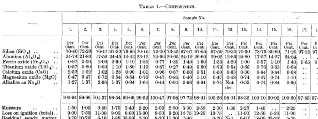
Associated with the conglomerates and plant-beds of Caim Range and of Manuka Creek are thin beds of bright shining coal. They are rarely more than a couple of inches thick, hut they have been prospected freely in the hopes that it might turn into something of commercial value, hut unfortu-nately without success. An analysis made in the Chemical Laboratory (by Mr. W. G. Hughson) of a sample from one of the layers from Manuka Creek gave the following result :
-Mechanical moi~>ture At>h (inorganic residue) Volatile matter Fixed carbon ..
Per Cent.
4
70 19 7
This result is somewhat :mrprising, ~>ince the hand-specimen suggests a coal of better quality and with more fixed carbon.
Similar coals occur in narrow seams in and near the hush in Bush Gully, on the south side of Cairn Range.
The presence of such a widely distributed conglomerate with greywacke pebbles closely resembling the rocks adjacent thereto implies an ·unconformity between the conglomerates and the parent rocks. The strati,graphical evidence in support of this is not convincing by itself, although there is nothing againrJt the contention. The differences in strike of the beds behind Captain Woodcock's house, also the fact that if the direction of the conglomerate heel on the southern flank of the Manuka Range is coi1tinued for a few chains in its apparently regular direction it will he found to he underlain by greywacke and to be abutting against greywacke with apparently different strike, also the features of the conglomerate lying to the west of Hill's Saddle, and the a.pparent discrepaney of the dip of the beds· on Rocky Ridge and Pull wood Peak, are all to some extent in favour of the contention, and support the inferenee drawn from the nature of the eonstituent pebbles of the conglomerate, that a definite ,stratigraphieal break oceurs, and that the greywacke belongs to an ea.rlier series and the conglomerate to a later one.
This set of beds in which conglomerates are somewhat important members is evidently widely spread in the Canterbury area. S. H. Cox refers to it in the gorge of the North Ashburton, where he assigns it to a later age than the Maitai greywa.ckes, and considers it overlies the latter unconformably. It also occurs in the Pudding Stone Valley, a tributary of the Upper Rangitata ; near Lake Coleridge ; and in the 1niddle. gorge of the Hurunui, just above Ethel ton. The latter oceurrence has some definite hearing on the age of the beds in the Malvern region, for it is interstratified with finer-grained beds containing calcareous concretions. A little while since an ammonite was discovered in the bed of the river not far, from this occurrence with a similar matrix to these concretions, and this has been classified by Marshall (1924, pp. 615-16) as of Jurassic a.ge, a fact which is not inconsistent with the determination of the conglomerates in the Malvern Hills as belonging to that period.
The age of the greywackes is determined as probably Lower Triassic from the similarity in their lithological eharacter to the beds in Mount Torlesse and elsewhere containing the annelid Tetebellina maekayi and other Lower Triassic fossils. I have not observed the annelid-tubes in any rocks of the Malvern Hills proper, but they occur in greywackes at the upper end of Rakaia Gorge, which is in close proximity. Thus we have a greywacke series of Lower Triassic age, and a conglomerate with sandstone and shaly beds containing plant fossils of Rhaetic or, according to Arber, more probably of Lower Jurassic age, if we can rely on plant fossils alone as a criterion for the determination of age. In this case it is all we have to rely on.
If this be definitely established it implies two periods of deformation in the formation of the Southern Alps. The pebbles in the widespread conglomerate imply that land of some elevation composed of greywacke was in existence when the conglomerate beds were laid clown. Therefore some deformational movements in the alpine area had taken place in later Triassic times, by which the land was raised above sea-level. 'l'here is no evidence from the area as to whether these movements Wflre merely uplift or attended with folding, but judging from the differing intensity of folding exhibited in the greywackes and the conglomerates it is a reasonable inference that some folding had taken place before the great revolutionary movements at the end of the Jurassic or in the early Cretaceous.
The matter of the names to be assigned to those two series remains to be settled. Marshall's name, Maitai, cannot be applied to both, but it may perhaps be applied to the underlying Triassic Series, although Morgan has perhaps more appropriately called these beds Holconui. I would suggest the name Wakaepa, the Maori name for the Selwyn River, since the set of beds is typically developed in the valley of the Selwyn not only in the Malvern Hills proper, but also in the valley of the Upper Selwyn in the foothills on the south-eastern flanks of Benmore.
'rRIAssw VoLCANICs-LAvAs AND AsH-BEDS.
A most important point to be considered now is the relation of the ash-beds to these two series-viz., to which of the two they ought to be assigned. These volcanics are best developed along a belt of country running north-east from the High Peak Saddle, through the Four Point Range, towards the head of Manuka Creek, a definite band following along the south side of the creek that runs just north of the Steventon Homestead and ·crossing on to the southern face of the Manuka Range, where outcrops occur in fairly close proximity to the Steventon Coal-mine. Another band occurs on the north side of Flagpole Hill, crossing the Selwyn near the upper end of the gorge, continuing over a low saddle to the east, and entering the valley of the Hawkins.
These beds consist of ash, with occasional flows of solid rock of basic composition. They were called diabase ash by Haast and by S. H. Cox, a name which may still be applied to them with propriety. Hutton has called rocks from the same belt leucophyres (1888, pp 271-74). The ash-beds themselves are much altered, very largely owing to the formation of a considerable amount of epidote, a secondary product derived from the F.M. niinerals and perhaps the basic feldspars present. They are associated with a crystalline limestone known as marble, and cherty beds stained by iron oxides and occasionally by manganese oxide. Interstratified with these are fine-grained detrital rocks in which grains of feldspar are important constituents. No definite fossils have been found in the ash in this district, but impressions suggestive of the form of Monoti.s were observed near the marble-quarry on the High Peak Saddle. However, M onoti.s and other associated forms have been reported as occurring to the north-west of Mount Thomas in ash-beds extending north-east from the Ashley Gorge towardsthe Okuku, whose relations are similar to those in the Malvern area.
The marble is of a finely crystalline variety, sometimes decidedly siliceous. It forms irregular-shaped, disconnected masses. The place where it is best developed is at Adams Quarry, to the east of the Selwyn, where it has been worked at intervals for many years as a source of high-grade lime for building purposes.
This bed of marble strikes north-east and south-west, and has a high, almost vertical, dip. The breadth of the bed is somewhat narrow, and does not exceed a chain at most. It is much faulted, most of the faults being strike faults, reversed at times, showing slickensided s~rfaces and frequent brecciation. It occurs in ash, probably as separate overlapping lenses, and the ash becomes subschistose along fault-lines.
10
Overlying these beds are siliceous rocks stained with iron oxide and manganese oxide, lying in a broad belt to the south-east several chains-perhaps half a mile-in width. These continue down nearly to the rocky gorge of Boundary Creek; but below the old camp-site at the bend occurs a bed of diabase with veins of calcite and crystals of pyrites freely showing, which no doubt belongs to the diabase-ash series, although it may perhaps be intrusive. This is succeeded again, before the gorge is reached, by normal greywacke, and then the succession is obscured by the rhyolites of Rocky Ridge and Pullwool Peak. Just above the gorge is an occurrence of intrusive basalt, which will be referred to later. This overlies a small occurrence of greywacke conglomerate of probable Jurassic age, referred to previously (p. 8). Small masses of marble also occur in the siliceous rocks between this point and the quarry, evidently on a parallel line, but the beds are twisted about in a remarkable way and their true alignment is difficult to determine precisely.
This remark also applies to an occurrence of marble in similar beds at the head of the valley leading down to Cleathing's old homestead. It may be on the same line as the deposit at the quarry or on a parallel line, though the first hypothesis is probably correct. This occurrence of marble strikes north-east, and occurs in siliceous rock stained black with manganese oxide associated with rock pink with the manganese silicate (rhodonite). The beds can be traced right down into the gully on a line running to the south-east of the highest point on the Four Point Range.
Stains of malachite have been observed on some of the siliceous rocks of the locality, and one of the cherty layers was definitely prospected for gold. This occurs on the face of the hill above the old camp. It strikes E. 30° S. and has a vertical dip, thus simulating a reef in appearance; but in close proximity there are hard siliceous rocks with veins of quartz interstratified with slaty greywacke which strike east-north-east and west-south-west, and dip south-south-east at high angles. The strike of the greywacke to the south-east of this band is definitely determined from observations on the road over the saddle, and shows an east-and-west direction, which is maintained on the hill called Golgotha, forming the ridge between the two branches of the Glendore Valley. The general arrangement of the ash-beds in this locality indicates that they are interstratified with the greywackes, and thus they represent interbedded sheets and ash-beds of the same date as the greywackes-that is, they are probably Lower Triassic.
There appears to be some break in the continuity of the ash-beds and the associated marble, since the next outcrops of the latter occur on the northerly face of the range near Limestone Saddle-that is, the saddle at the head of Middle Creek, which is about half a mile to the west of Hill's Saddle. Marble also occurs in ash-beds near the crest of the ridge at the head o£ Middle Creek, and also along its southern side in a narrow belt which crosses the creek lower down, so that pieces of marble can be picked up at the foot of Manuka Range just opposite to the coal-mine.
The ash-beds are usually greenish in tint, but the diabase is frequently reddish. They are apparently interstratified with the greywacke, and the strike of the beds is the same. Along the south side of Middle Creek this is approximately east and west, whereas at the head of the gully near the saddle it is almost at right angles to this direction, being north-north-west and south-south-east; but the general line in a north-east and south-west direction is resumed immediately to the west of the saddle, where isolated masses of marble occur in the ash. I could not make out for certain whether this disagreement in strike is due to a local bending of the beds south of the saddle or due to the incoming of another layer of ash at a slightly different angle. The latter seems more probable.
The diabase beds in Selwyn Gorge are not on the same line with the beds following along Four Point Range. They may be at a different horizon, but they may be at the same horizon as the result of folding. In the vicinity of Hill's Saddle the beds are anticlinal, and the southern and western faces of Flagpole Hill show that they are part of the limb of a fold with a general dip to the north, so the latter supposition may be the correct one. In the gorge the strike is north-east and south-west, and the dip is almost vertical. The green colour of the beds suggested to prospectors the possibility of copper, and two or more drives were put in, with a negative result. The ash-beds are interstratified with greywacke. Siliceous rocks also occur, sometimes as definite beds of jasperoid material, and again as jasper in the ash ; occasionally it is whitish in colour, resembling the reef worked OJ;:t the High Peak Saddle.
It may be interesting in this connection to report the occurrence of marble in the Thirteen Mile Bush on the south-eastern face of Big Ben Range. This and the occurrence of plant fossils of Jurassic age, kindly collected and lent to me by H. Robb, suggest that other lines of marble and associated beds occur to the north-west of the lines already definitely known in the Malvern Hills proper. I have seen none of these, since my examination of this part of the country has been very meagre, and the country is extremely difficult, owing to the covering of bush and its general roughness.
They Occur over several hundred feet in altitude, but their precise limits are difficult to locate. The main band is bounded on the south-east side by greywacke, and there are small subordinate strips higher up the ridge parallel to the mam band. The rock varies in the hand-specimen, but frequently shows tints of dark green, lighter green, and with a yellowish tinge, and reddish and greenish quartzose layers, sometimes stained with manganese dioxide, similar to those in the country to the south-west on the High Peak Saddle, frequently occur parallel to the ash-beds. The strike of the diabase, as well as of the associated greywackes and argillites, is north-east and south-west, with a dip to the south-east at high angles. It is possible that other bands may occur south-east of the one just referred to, more on the strike of those occurring in the Four Point Range.
The solid material of the ash-beds, no doubt belonging to contemporaneous flows, is generally light yellowish-green in the hand-specimen, sometimes a dark green. Under the microscope it proves to be a diabase of moderately fine texture. The feldspar is in the form of laths, of fairly uniform length, averaging about 0·3 mm., and oriented irregularly to the augite, which shows a subophitic relationship. It has an index higher than balsam, and an extinction angle corresponding generally to that of an andesine, and it frequently shows a denticulate border of more acid facies. Phenocrysts do not occur.
There is much augite present, greenish-grey in colour, and usually showing signs of decomposi-tion. Epidote is a notable constituent, as well as a stain of chloritic material which specially colours the alteration- products occurring in cavities and veins. The yellowish- green tint that the rock frequently exhibits is no doubt due to the presence of the epidote and chlorite. In some of the less-altered varieties olivine appears, but in the less-altered forms it does not show as a separate entity. Calcite and quartz-notably the former-occur frequently in veins and cavities, and also ilmenite in grains with denticulate borders and in broken comb-like forms.
The ash under the microscope appears to be composed of fragments of the same variety of rock, augite being the dominant constituent of the grains. Epidote occurs very freely, as well as calcite.
These forms pass gradually into the marble, with an increase of the calcite constituent; but transitional forms have always a percentage of epidote. Some of the marbles show a fair proportion of quartz ; but then, again, some are practically pure calcite. I have seen nothing in the evidence to suggest that the marble is an alteration-product of the ash, and represents the accumulation of the calcium constituent of the feldspar and altered augite of the diabase, seeing that the large quantity of epidote accounts quite satisfactorily for what has disappeared. It seems to me more probable that the marble represents the calcareous constituent of a calcareous tuff laid down on a sea-bottom contemporaneously with the deposition of the ash.
Although it seems reasonable that all the diabase material is either ash or flow, some rocks remarkably like it in general appearance may be clue to subsequent intrusions. This remark applies specially to the occurrences at the head of Boundary Creek, above the rhyolite gorge, though I think it more likely that they, too, are merely interbedded sheets like those associated with the ash farther to the north-west.
One or two of these diabases show decided relationship to spilites, and their association with jasperoid rocks is interesting in view of the frequent occurrence of the two types in conjunction. The general texture answers to the description of spilites, but the feldspar is hardly sodic enough, being not more acidic than oligoclase, with an index of refraction practically equivalent to that of balsam, and an extinction angle corresponding to an oligoclase. Although some of the mineralogical characters indicate a relationship to spilites, the rocks are not so completely decomposed as is the case with typical spilites, and the feldspars ·are singularly fresh, unaltered, and do not show the characteristic terminations of spilitic feldspars. More work is therefore necessary in this connection before the spilitic character is definitely established.
The general occurrence of manganese oxide forming a stain on the rocks in the vicinity of these ash-beds is a matter of some interest. Hutton considered that the presence of manganese in the greywackes might be taken as indicating that they were a deep-sea deposit, a conclusion he had come to on other grounds. It appears to me, however, that the manganese may be traced to the volcanic rocks themselves. In the analysis cited by Hutton (1888, p. 273) the percentage of manganese oxide present is given as 0·73, and the concentration of this amount from decomposed ash and lava in the surrounding rocks would account for the small amount they contain without necessitating the assumption that the manganese represents the nodules characteristic of abyssal marine deposits.
In addition to the ash-beds and associated diabase, which are contemporaneous volcanics, there are igneous rocks of later elate intrusive into the above-mentioned series.
One instance of these is no doubt connected with the rhyolites to be referred to later. Two dykes of this rock occur near the end of Cleathing's Road with a N. 30° E. strike, so that they appear to have originated from somewhere near Rocky Peak, as if it was the centre of disturbance. The more easterly of these crosses the ridge between the two tributaries of the Glenclore Stream which come from the south-eac;t slopes of the Four Point Range, and it can he traced as far as the High Peak Road, where it is exposed in a cutting. When followed to the north-east it apparently turns in direction till its alignment is almost north-east and south-west, being directed almost to the saddle over which the road passes. The second dyke can be followed across the ridge clown into the western gully, but it is not known farther south-west for certain, although it may also cross the road, since at the spot where it :ohould do so is a collection of rhyolite boulders but no rock in position. Another rhyolite dyke occurs on the western side of Ahner's Head, which I found some years ago hut have not been able to locate again. On the northern face of the same hill there is an outcrop of rhyolite, evidenced by the occurrence of numerous boulders of rhyolite over an area of a few square yards; hut this could not be traced in the surrounding greywacke, nor could the actual contf).cts he seen in order to determine whether or not they were from an intrusion. .
Another rhyolite dyke occurs in graywacke in the creek coming from the Brockley Mine, south-east of the main adit, and this also can he traced south-west through the rhyolitic knob between. this creek and the headwaters of Wairere Creek, and it may continue on to .the north-western face of the ridge determined by the sill behind the Glenroy Mine. But, of course, all these occurrences are connected genetically with the rhyolite igneous rocks to be referred to later.
Besidec; these acidic rocks, there are intrusive into the greywackes a number of basic dykes. One of these occurs north-west of the rhyolite dykes near Cleathing's, running ab;nost parallel with them. This crosses the ridge just referred to; and a dyke does occur on the High Peak Road, very much weathered, and about a foot in width, which may he a continuation of the dyke in that direction. Another basic dyke occurs on the southern side. of the Cairn Range, and other basic rocks, probably intrusive, along the junction of the rhyolites and the pre-existing sedimentarias near the crest of the range from Pullwool Peak to the rocky ridge east of High Peak. The special occurrences of this are-(1) North-east of Pullwool Peak; (2) near Hood's Bush, on the north-east slope of Rocky Peak; (3) on both sides of Boundary Creek, above the rhyolite gorge; and (4) on the actual crest of the ridge south of the marble-quarry. The first, third, and last of these overli'e the Lower Jurassic conglomerate, and the second apparently overlies graywacke, though the conglomerate may be there too. Nos. (3) and (4) were known to Haast, and he considered them .as belonging to the andesites so well developed farther west. This would be their proper position according to his ideas of the sequence of volcanic rockc: in the area, seeing that he considered them effusive and not intrusive-viz., they were overlying the greywackes and underlying the rhyolites. They are, however, judging more from their microscopical features than their field relationR, which are somewhat obscure, uot ::;o much related to the andesites as to the basic rocks, which are certainly intrusive into the Senonian beds. I should therefore consider them as of a later date than the andesite::;.
(b) JURA-CRETACEOUS VOLCANICS.
ANDESITES AND RHYOLITES : THEIR FIELD RELATIONS.
In addition to the diabase-flowc; and ash-beds of Triassic age, there are two series of pre-Senonian volcanics. One of theE\e is a hypersthene-augite andesite, and the other a garnetiferous mica rhyolite. The former consists of flows and clastics, while the latter occurs in several facies ranging from what is practically a quartz-porphyry to a pitchstone, the last-named probably occurring as dykes, though in some ca.ses they may be merely a chilled facies of the ordinary rhyolite and nbt intrusive. In -·addition, there are clastic rocks associa~ted with the flows. Both Haast (1872, pp. 12'-18) and S .. H.
The whole question presents serious difficulties. On the eastern margin of the exposed andesite near the summit of Middle Saddle-a depression in the Rocklyood Range crossed by a distributary ice-stream at the time of the maximum ice-flood-and also lower down the slopes to the north, there is some evidence that the rhyolite is the more recent of the two. Here an outlier of fragmental rhyolitic breccia or agglomerate several acres in extent and 50 ft. thick apparently rests on andesite, and if this could be definitely substantiated it would appear to settle the relative ages of the two series as far as this locality is concerned. But on the southern side of the saddle in close proximity, round the head of the western branch of Rockwood Creek, and, of course, farther south-west, the andesite is certainly on top of the rhyolite. The patch of rhyolitic breccia may, after all, be an inlier, and owe its appearance to the denudation of the somewhat thin cover of andesite which masks the rhyolite in the vicinity of the saddle. This probably explains the presence of the inlier of pitchstone and pitchstone breccia surrounded by andesite at the head of Wash pen Creek, near the saddle, just north of Round Top. Near the Switching Station at the western end of the Rockwood Range, at the point where an adit was driven on the contact of the andesite and rhyolite in the hopes of striking copper in payable quantity, the andesite rests on the decomposed surface of the underlying rhyolite, and suggests that the andesites were poured over an old land-surface of rhyolite. Therefore we have the following alternatives :
-(1) The andesite is the younger of the two-as it apparently is, judging from its general position on top.
(2) It is the older of the two, and owes its position to (a) being lifted up by the process of endogenous growth of the rhyolite as suggested by Cox; or (b) the rhyolite being part of a large intrusive mass which has lifted the andesite in a manner somewhat similar to (a) ; or (c) faulting, the andesite having been thrust over the rhyolite, the over-thrusting in the neighbourhood of the Switching Station having come from the north-west, the last-named supposition being supported to some extent by definite evidence of faulting of this kind on approximately the line of contact of the two volcanics in the neighbourhood of Rakaia Gorge. All the same, a belt of rhyolite fringes the andesite along the greater part of the north-west flank of the Rockwood Range, and so this explanation will hardly apply.
In the neighbouring Mount Somers district, where similar senes of andesite and rhyolite exist, the andesite appears to be the older of the two.
The chief reasons for this conclusion are :
-(1) The rhyolite does actually lie above the andesite on the northern side of Mount Somers at the head of Chapman's Creek.
(2) Fragments of andesite are found in a pitchstone breccia. (3) Apparent intrusions of rhyolite are found in andesite.
(4) There occur patches of rhyolite which were in apparent continuity at one time but are now separated as outliers of the parent mass as the result of erosion.
These reasons are, on the face, apparently conclusive as to the rhyolite being subsequent to the andesite; but at Rakaia Gorge itself, as pointed out by P. T. Cox, it is difficult to explain the relations on any other assumption than that the order is reversed. It does not seem at all likely that there are two andesites in the Rockwood Range, one older and the other younger than the rhyolite, since andesite occurs in unbroken continuity from Middle Saddle right to the south-west end of the range. There are one or two occurrences of volcanic rock, especially those near the Rockwood Home-stead, which no doubt prompted both Haast and S. H. Cox to suggest the order of eruption that they did. Two of these lie north of the homestead, and there may well be others hidden by the scrub. They were considered by Haast to be andesites like those of the general run of the rocks. This conclusion is supported by microscopic evidence. As far as can be seen, these rocks rest on rhyolite ; there is a good exposure in a creek about a mile north of the house showing this clearly, but in one place at least the andesite rests on rhyolite with rhyolite exposed on the hillside just above it. This may be due to erosion of a thin veneer of andesite, and the rhyolite ms,y be an inlier. This occurrence of andesite can be connected up by blocks lying on the surface and traced to the west into the bush, and on to the end of the spur coming down between the two branches of Rock-wood Creek.
::>f rhyolite. Their peculiar position at various levels may be due to faulting. In the present state of our knowledge the proper explanation cannot be selected from these possibilities.
A somewhat important point which has bearing on the relations of these beds is the general irregularity of the upper surface of the rhyolite on the south-eastern flank of the Rockwood Range. No actual contacts are exposed, but it is very clear that the surface of the rhyolite shows irregularities in elevation amounting at times to several hundred feet. This is clearly seen, since 1its upper surface
forms a distinct shelf or shoulder along the length of the range in this section. It does seem unlikely that if the rhyolite is intrusive its form should be so irregular. Of course, the irregularity might be the result of subsequent faulting on lines generally across the range ; but it is much more probable that this feature is due to the fact that the rhyolite was eroded before the andesites were poured over it, and that these filled up gullies and valleys resulting from such erosion, and hence the irregular contact. The occurrences of breccia on the top of Middle Saddle and at the head of Wash pen Creek would thus be parts of the underlying rhyolite surface exposed as the result of erosion. This seems to be a probable explanation of its existence. Breccias are, no doubt, at times connected with intrusions, but the area exposed in this case seems somewhat against its being the result of intrusion, and it is more probably an ordinary volcanic breccia formed normally as the result of explosive action on or near the surface.
Another problem is prtisented by the occurrences on the end of the spur on the opposite side of the river from the Rockwood Homestead. Igneous rocks appear along the river-bank as it skirts the spur, and these are dolerites of the usual type, containing much titaniferous augite, often ophitically intergrown, and titaniferous magnetite or ilmenite. All outcrops apparently belong to the same mass, but on the up-stream side of the spur, and in apparent continuity with the doleritic facies, there is a more acid one, still with ophitic patches, but much weathered. There is an occasional development of the decomposed material in the doleritic facies, so that they may be variations of the same dolerite. An undoubted andesite, similar to the other andesites of the area, does occur in the vicinity of the point, but its field relations are uncertain.
The whole question thus presents serious difficulties, and, as I have not sufficient opportunity at present to decide the case one way or the other to my complete satisfaction, I have left the solution of the problem to Mr. S. J. H. Sylvester, a student who has been of the utmost assistance to me in many ways, in the confident anticipation that he will do his best to come to a correct conclusion. All the same, my present opinion is that the rhyolites are the older of the two rocks.
The actual age of the two series cannot, in the light of what we now know, be stated more definitely than that they are subsequent to the Lower Jurassic conglomerates and plant-beds, and are anterior to the Senonian coal-measures. If due weight be given to the definite unconformities which exist both below a.nd above these volcanics, it seems reasonable that they be assigned either to the Upper Jurassic or Lower Cretaceous, and their origin is probably connected genetically with the revolutionary movements which resulted in the formation of the Southern Alps. If this can be determined precisely, then it will throw considerable light on the actual date of these volcanics.
(i) RHYOLITES.
The rhyolites of the area are specially developed on the northern and southern flanks of the Rockwood Range, the former strip extending from near the south-west extremity to High Peak, and the latter from Rakaia Gorge (see P. T. Cox, 1925, pp. 95-97), past the Point Station to just behind Rockwood Homestead, when this strip junctions with the first and continues north-east, forming the highest part of the ridge in the elevations known as Rocky Peak and Pullwool Peak The last named is divided from a further occurrence to the east, known as Mount Misery, by the saddle called Yorkie's Pass. The rhyolite rests either directly on the Trias-Jura beds, as at High Peak, Rocky Peak, Pullwool Peak, and Mount Misery, or with the doubtful intervention of the andesites as referred to previously. From Pullwool Peak a ridge extends to the south-west on the east side of the valley of the Upper Hororata, and on the south-east flank of Mount Misery there is an extension outwards, which is marked by a fine old beech-tree growing on an almost bare outcrop of rhyolite in position.
There are, besides, one or two occurrences of rhyolitic dykes separated from the main mass, as near Cleathing's old homestead, and on the northern and western flanks of Abner's Head and in the valley of the Wairere. These instances of dykes are quite apart from the pitchstones associated with the main mass of rhyolite.